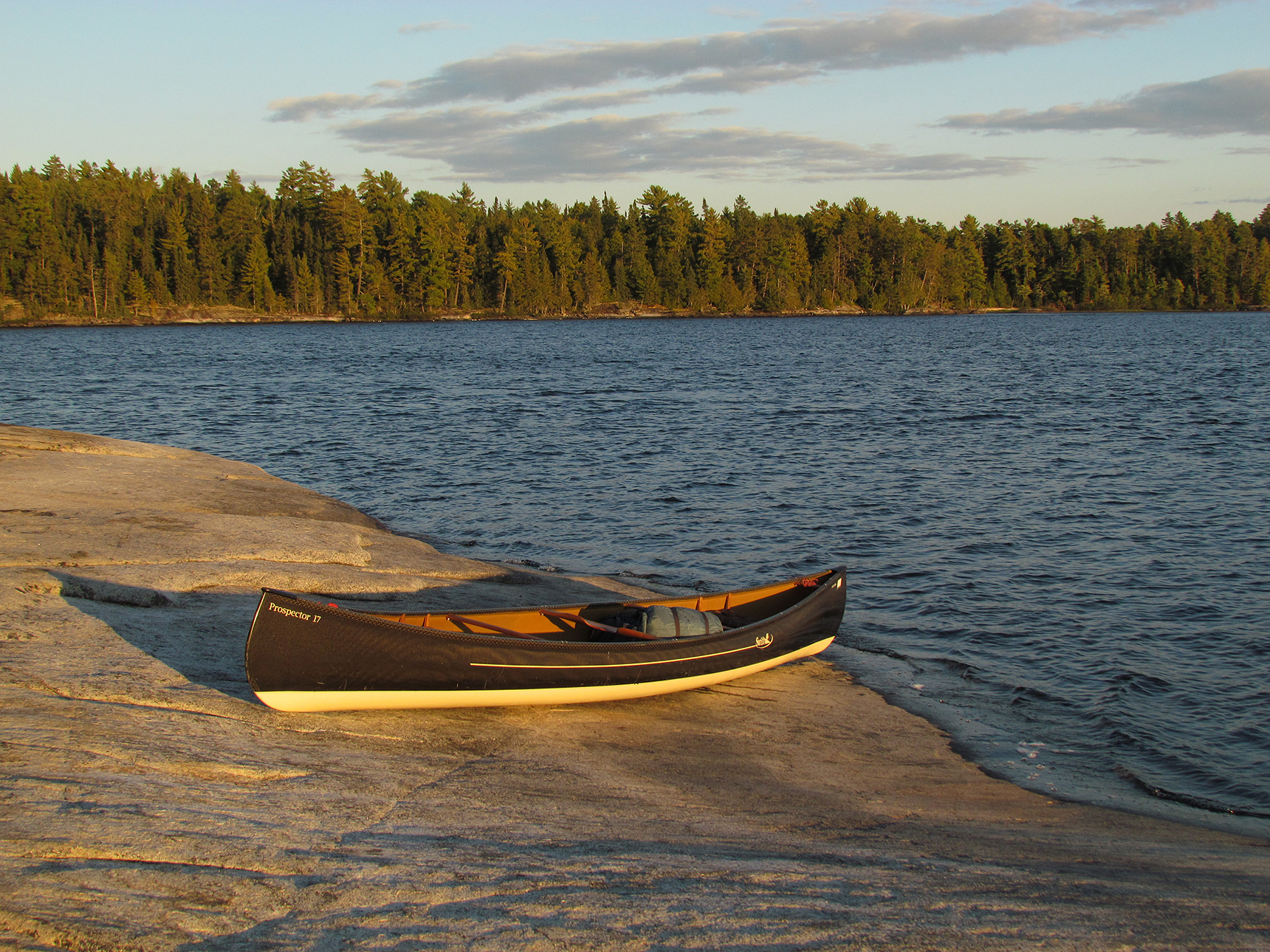
After bailing out of Temagami earlier than expected last month we were ready to rock it out on our first backcountry hiking trip with new dry bags, new rain gear, and new boots fore Aaron!
We had 8 days to hike the famous La Cloche Silhouette Trail in Killarney Provincial Park. At approximately 78 kilometres in length, this loop goes over the mountains and beside the lakes that makes this one of the most scenic, and also one of the most strenuous hikes in Ontario. We were stoked, though the extended forecast was less than ideal with rain forecasted almost every single day. Would this affect our inaugural attempts at the La Cloche Silhouette trail? The short answer…yes…yes it did.
Sites: Site #1 George Lake Campground, H7 (Topaz Lake), flat spot on trail leading to Topaz Lake
Average Daytime High: 7.5 Celsius
Average Nighttime Low: 3 Celsius
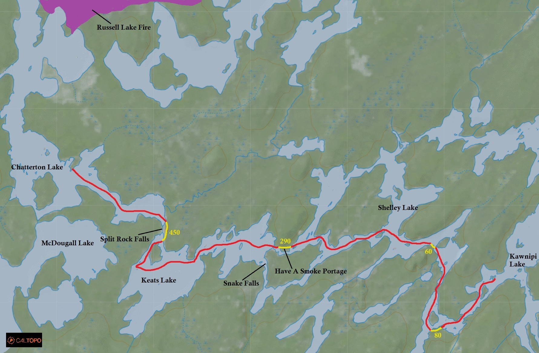
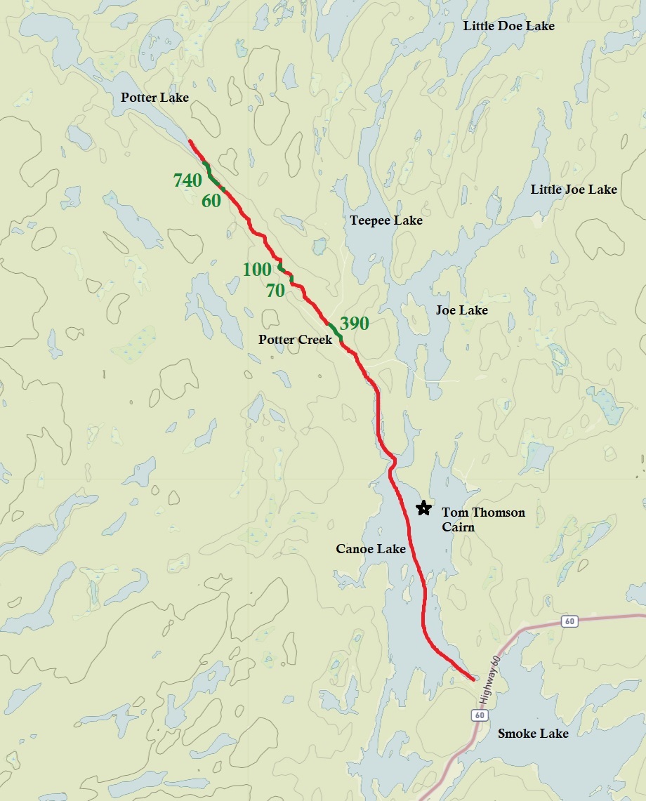
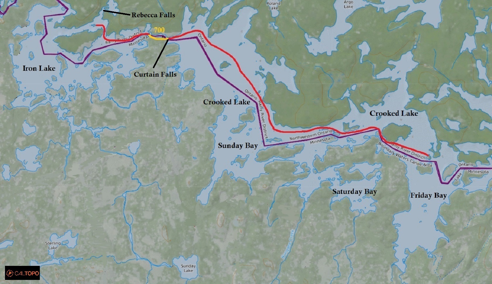
Maps Used: Ontario Parks Killarney Provincial Park Backcountry Hiking and Canoe Route Map (2014). Jeff’s Map Killarney and the Georgian Bay Coast (Version 2.0)
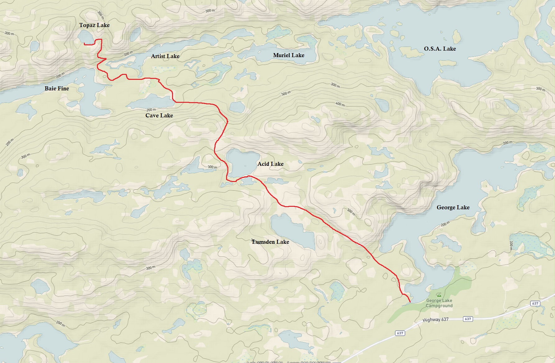
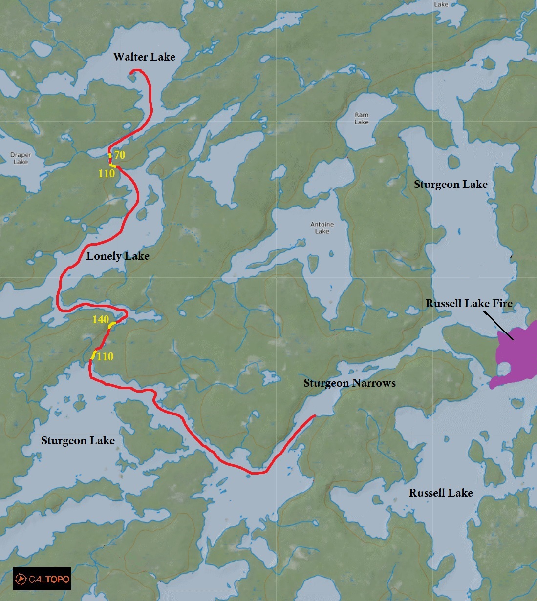
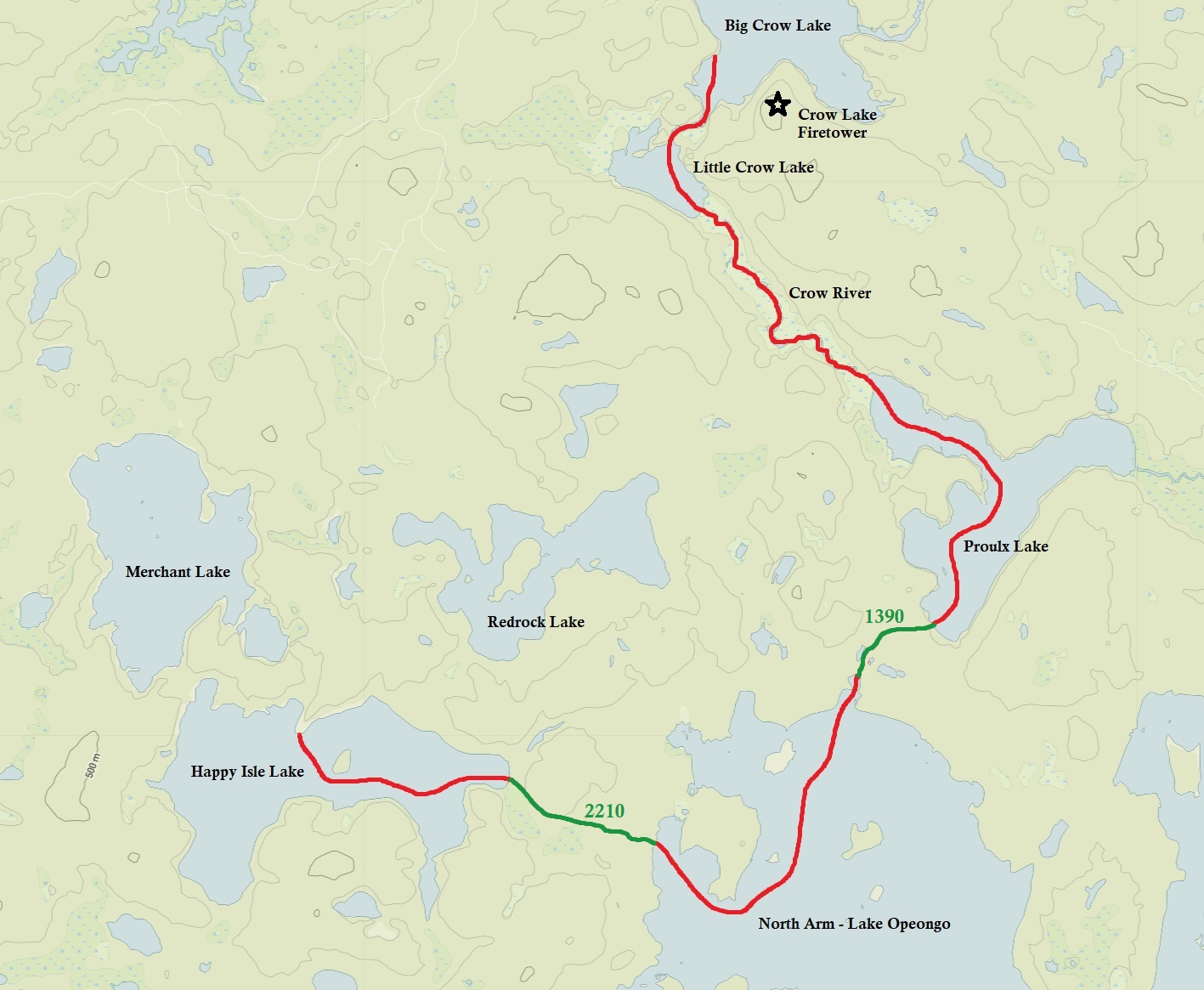
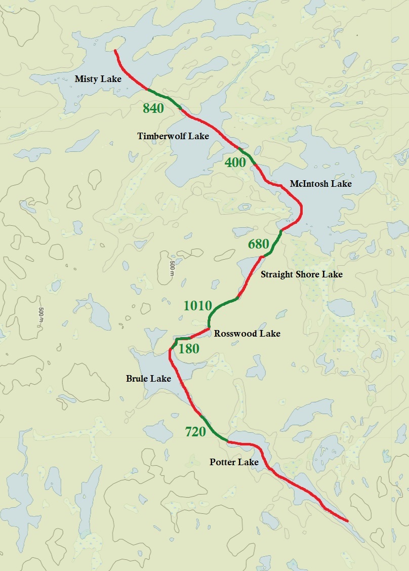
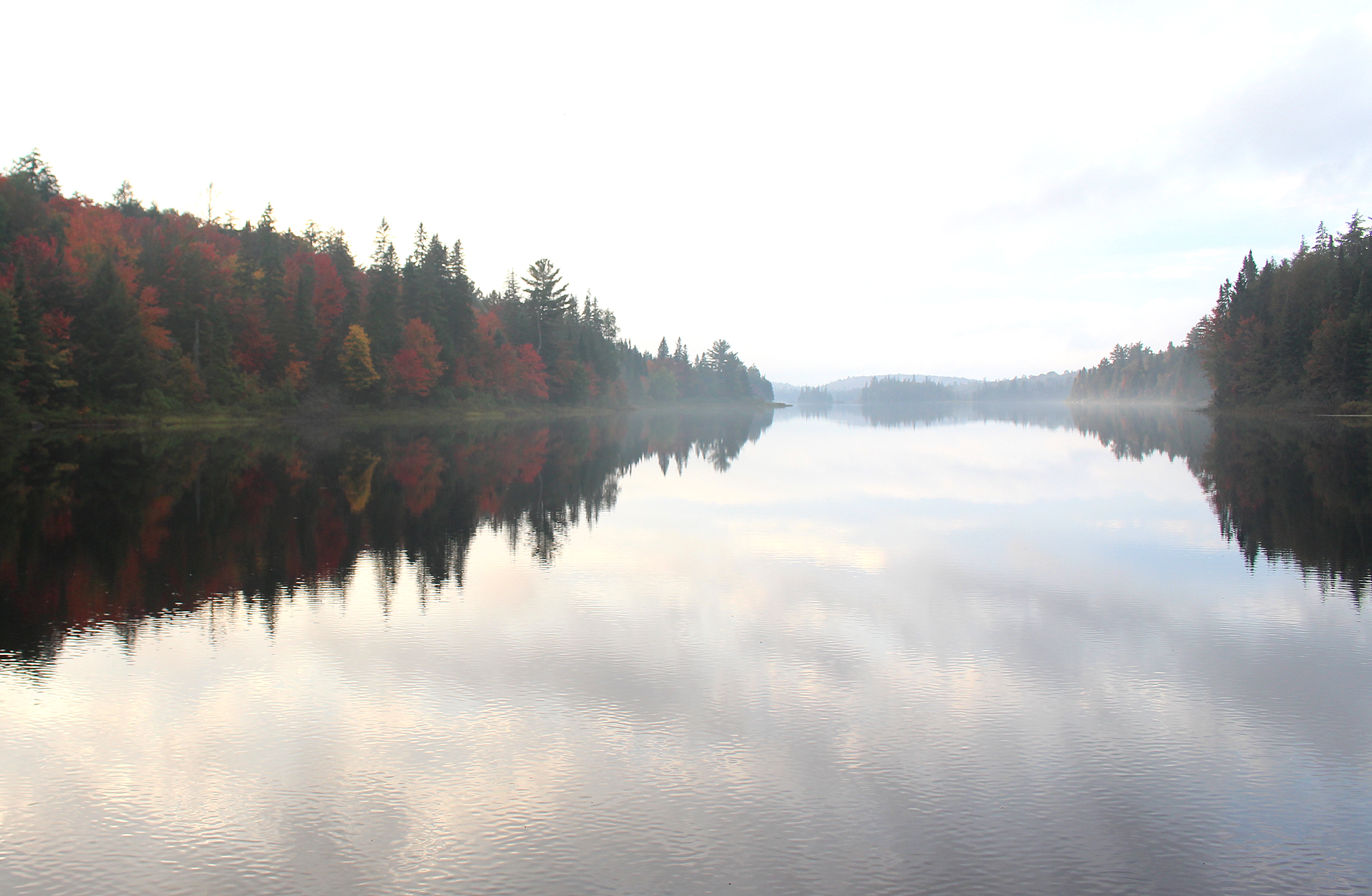
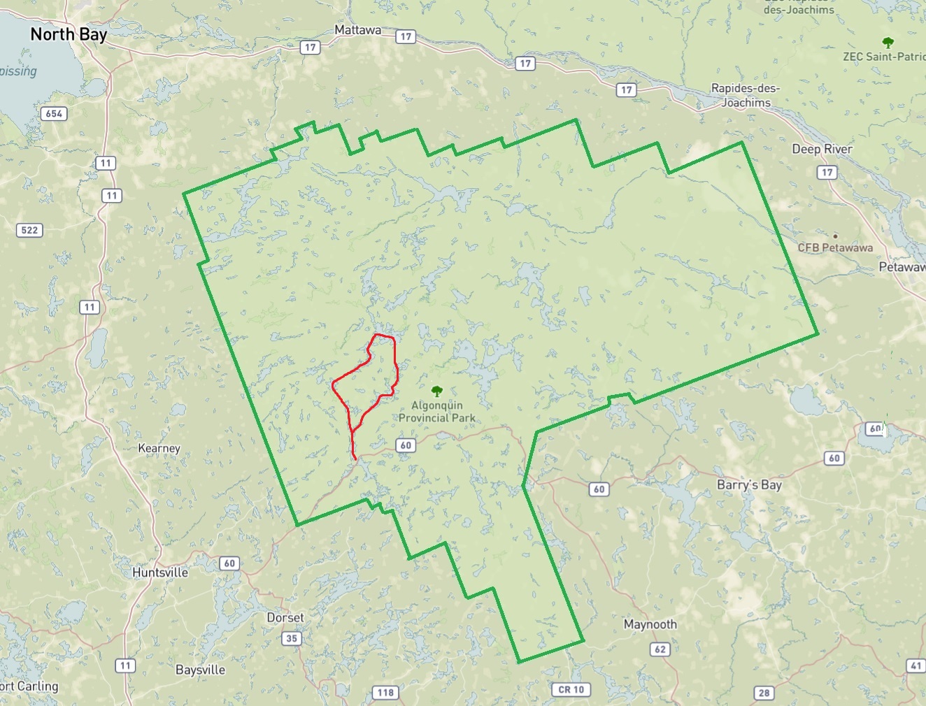
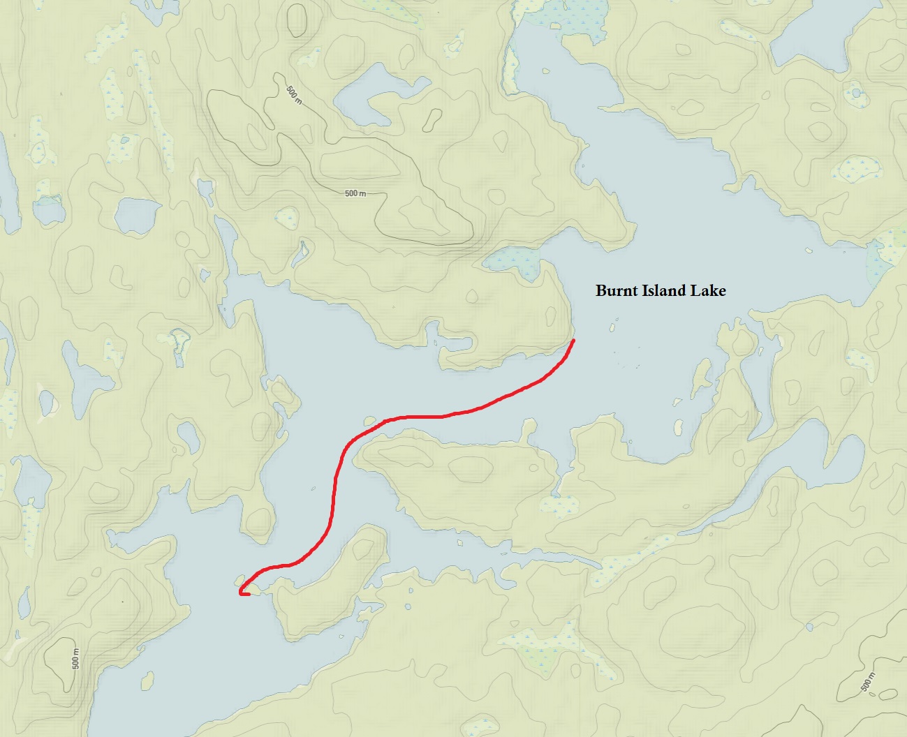
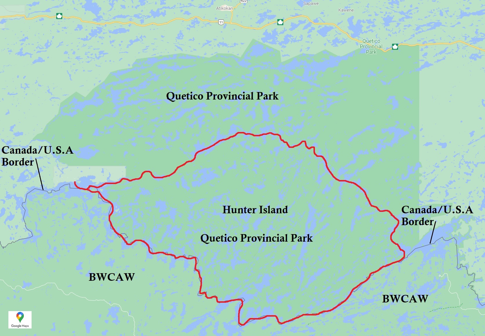
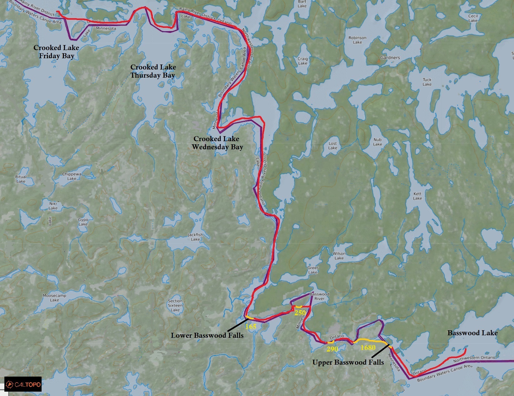
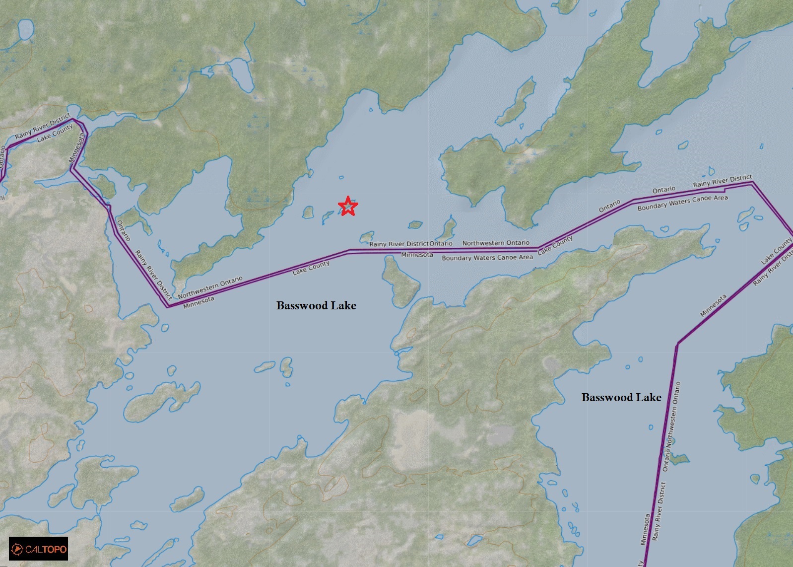
Killarney Provincial Park with a rough outline of the La Cloche Silhouette Trail in red. (click image to enlarge). topoView USGS.
Day #1: George Lake Campground
Weather: Mainly cloudy skies. Breezy with a rain shower in the late afternoon. Party cloudy in the evening. High: 8 Celsius Low: 4 Celsius
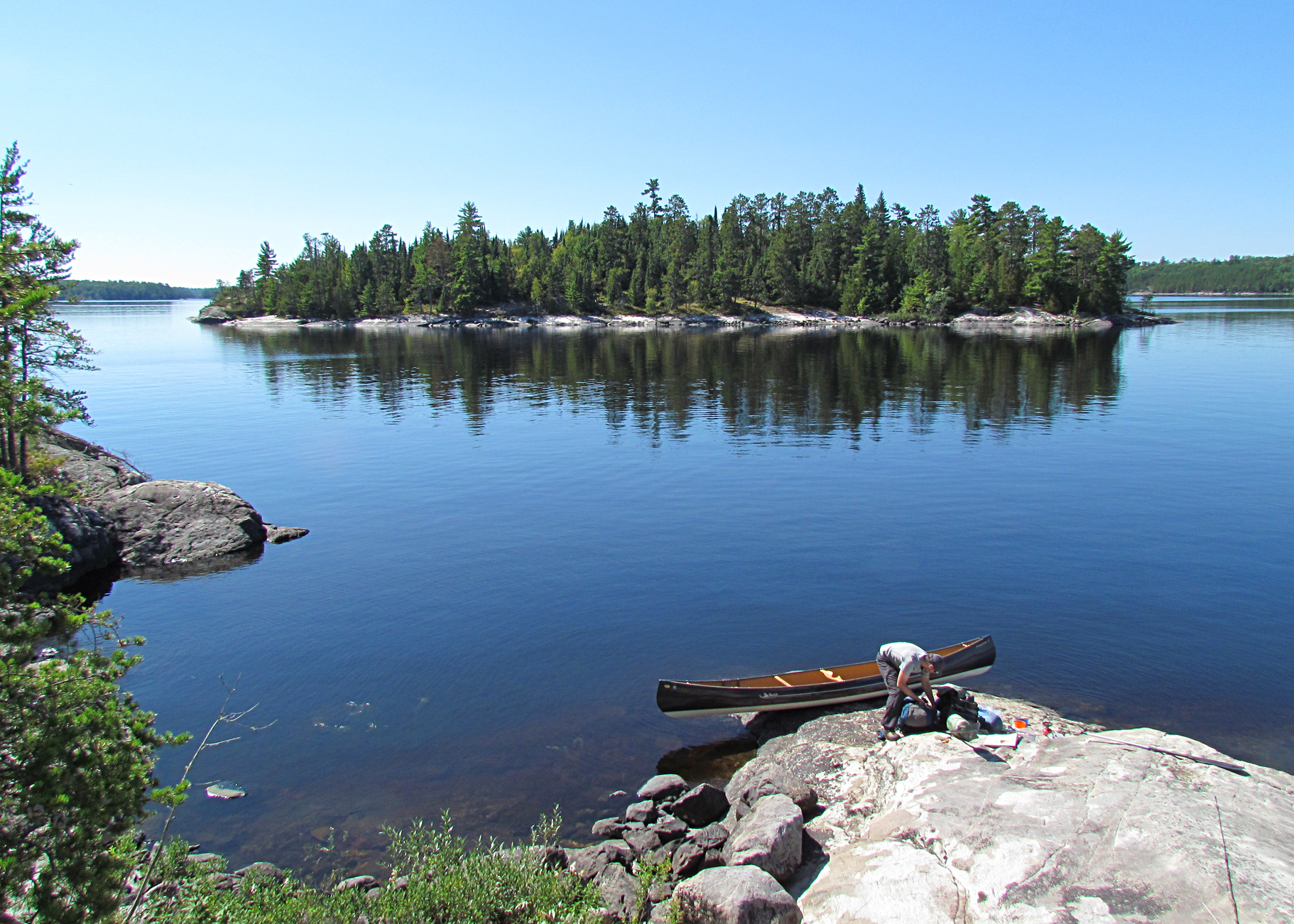
We have arrived!. (click image to enlarge)
We arrived at Killarney Provincial Park around 3:30pm and picked up our permits for both the George Lake campground where we will stay tonight, as well as for the backcountry. It’s cloudy and the fall colours were past peak with some leaf fall already. Our car camping site at George Lake was Site #1, a pretty mediocre site with other sites right beside us, as well as a trail to the comfort station. We have become backcountry snobs now so even staying somewhere within view of another person is too crowded for us.
Our site at the George Lake Campground. (click image to enlarge)
Because of the continuing coronavirus Covid-19 Ontario Parks has closed all of the showers, but luckily the washrooms are still open with flush toilets. We were a very short walk from the facilities to use the flush toilets and brush our teeth.
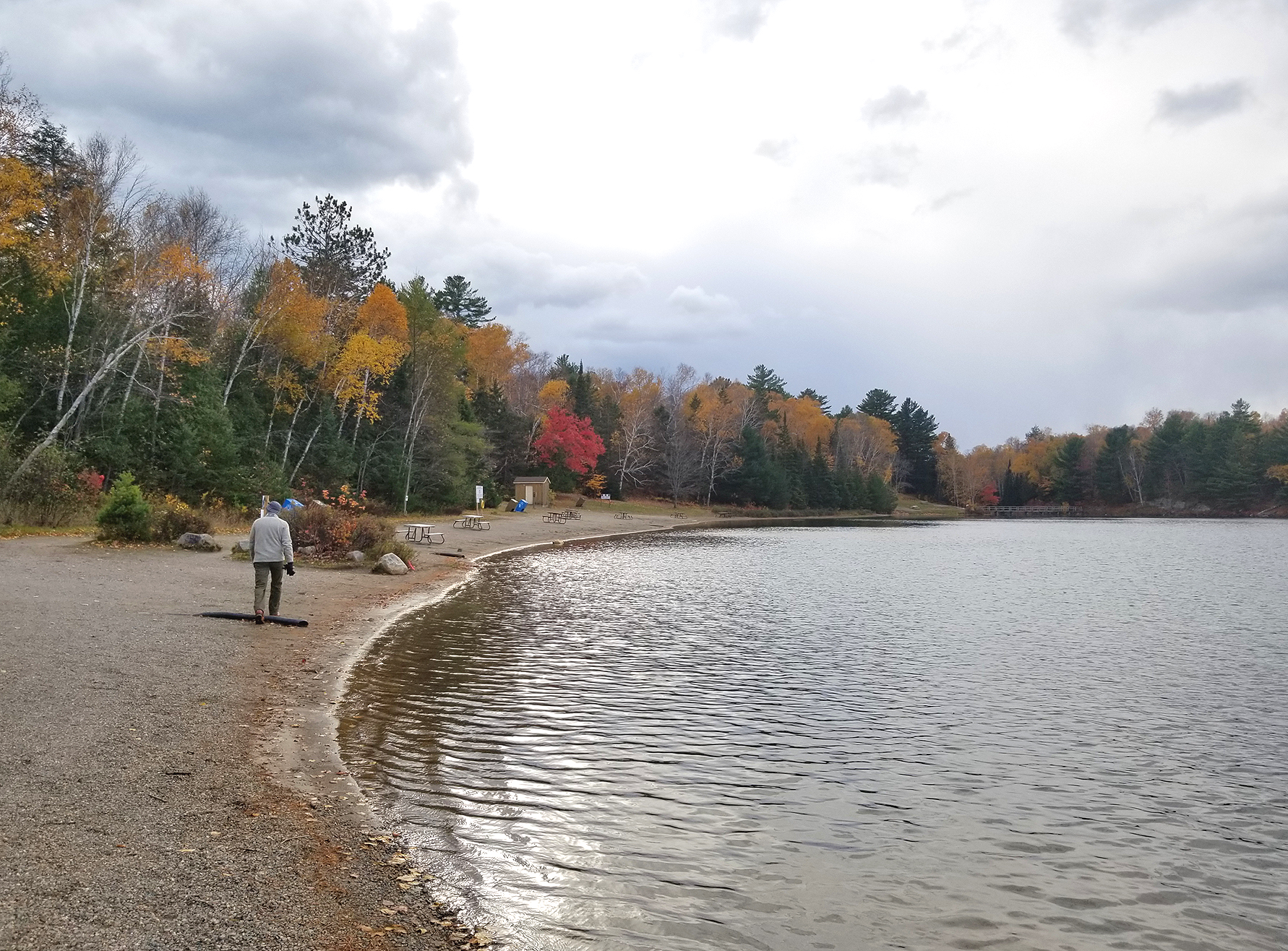
After setting up the tent we went for a walk down to George Lake, a lake we have launched from and paddled its’ length more than once. It was a bit chilly in the late afternoon as we went for a walk to the La Cloche Silhouette trailhead, crossed the bridge over George Lake, and climbed up a rock to stretch our legs after the long drive. On our walk back we noticed a dark cloud approaching. We had on and off rain showers on the drive up in the French River area so we figured this cloud also had a descent shower in it. We arrived back to the tent just in time before the rain fell. Luckily it was brief and we got a second chance to go for a walk and grabbed a few last things from the car. After dark our immediate neighbours arrived including one with a guitar. Big day tomorrow for us so lights out at 9:15pm with hopes of a good nights sleep!
The beach along George Lake. (click image to enlarge)
Wildlife Sightings: Eastern Chipmunk, Red Squirrel, Black-capped Chickadee, Common Raven, American Crow, People
Remember to: Find out which setting on our headlamps uses the least amount of battery.
Day # 2: George Lake to Topaz Lake
Weather: Partly sunny with graupel briefly in the morning, rain and wind by evening. High: 7 Celsius Low: 3 Celsius
topoView USGS. (click image to enlarge)
We woke up before the alarm went off at 6 am. Unfortunately we had restless sleep last night. There was a group of guys near our site last night that were yelling, laughing, and probably puking. While Marianne gathered up the items in the tent, Aaron prepared breakfast, only to come back to the tent with a message “I think we forgot the morale tea”……………………………………………………………………………………………………………………………………………………………….what?
How could this have happend?! Morale Tea (Twinning’s Irish Breakfast Tea) is what it says it is, a morale booster especially on those cold chilly mornings. Instead, we had to resort with a cup of hot water to drink with our cold muesli cereal. It was okay.
Dawn at George Lake. (click image to enlarge)
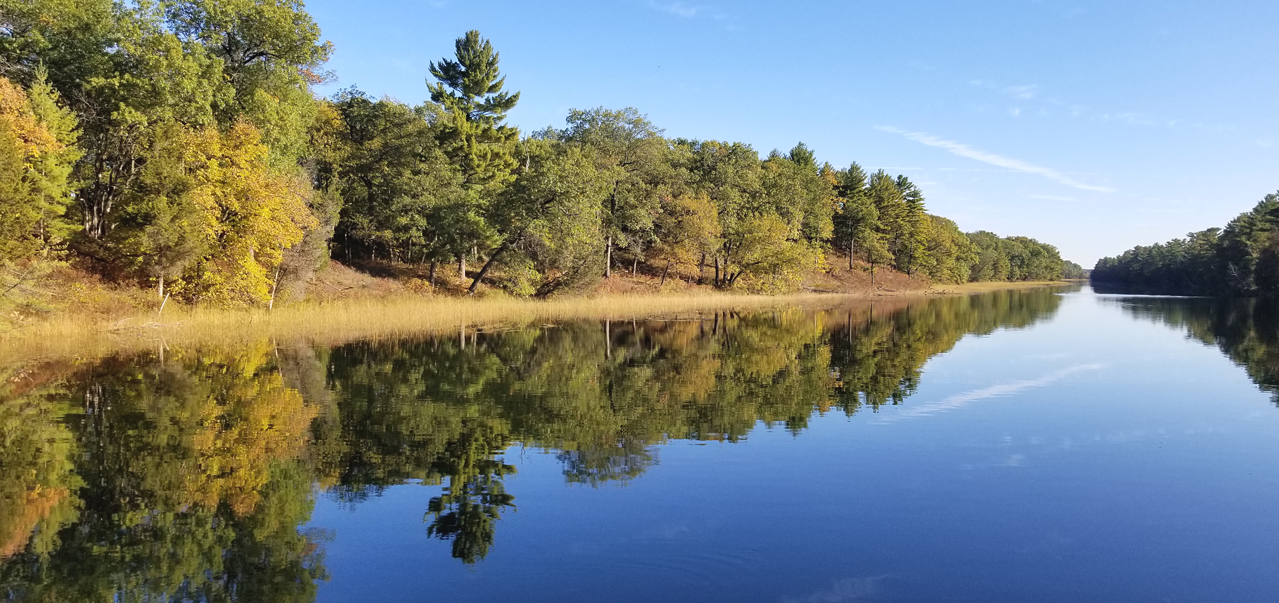
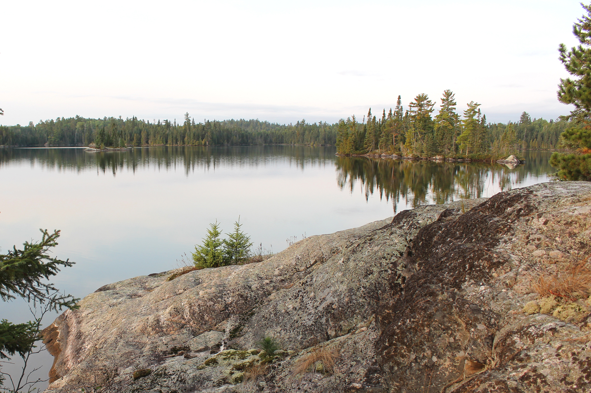
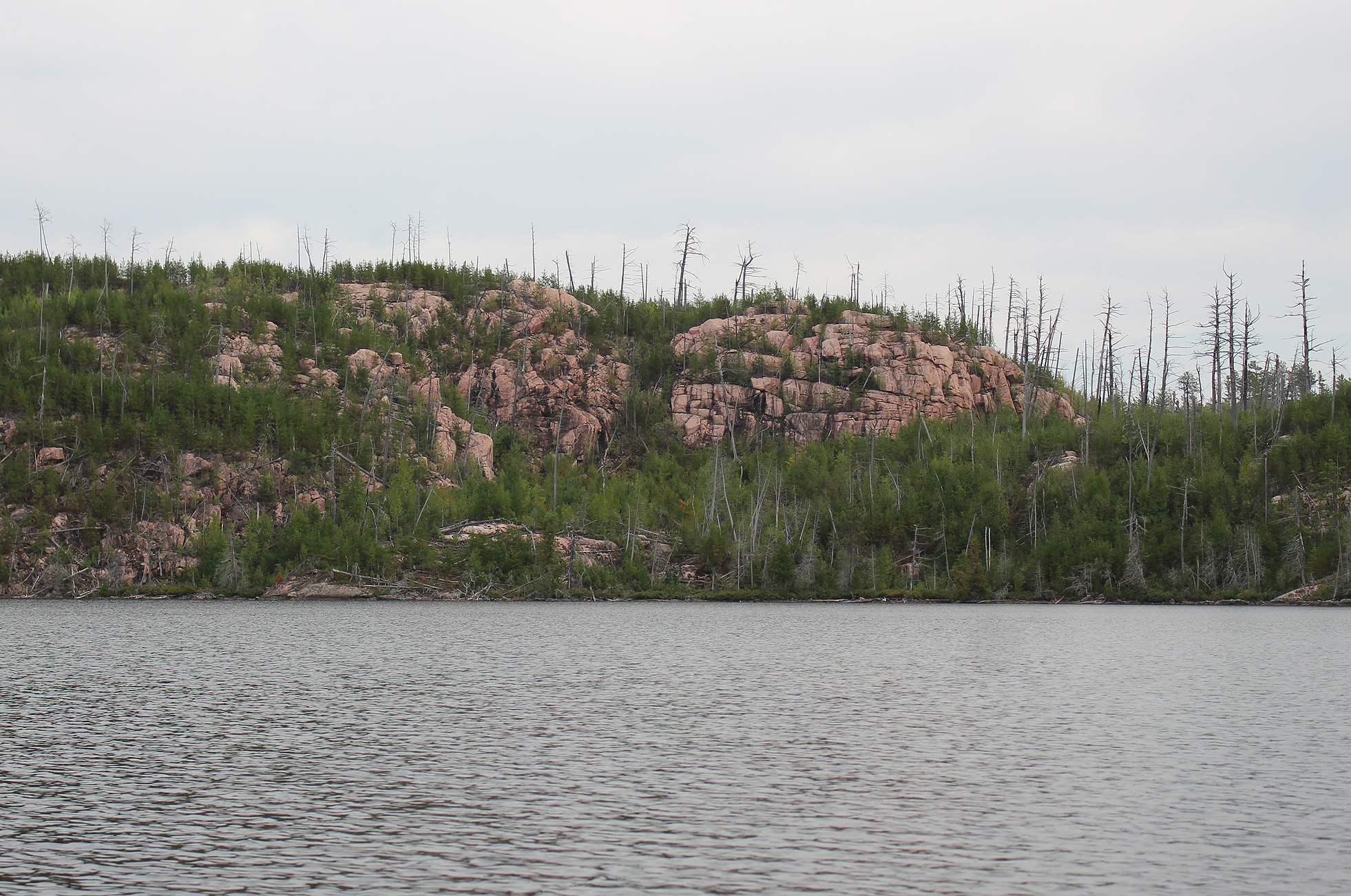
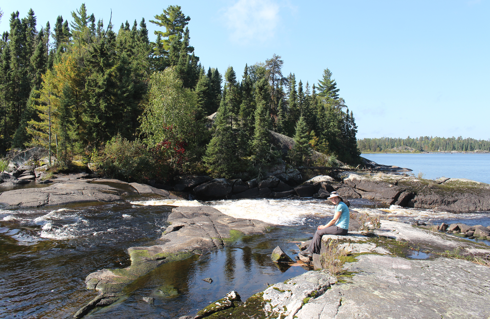
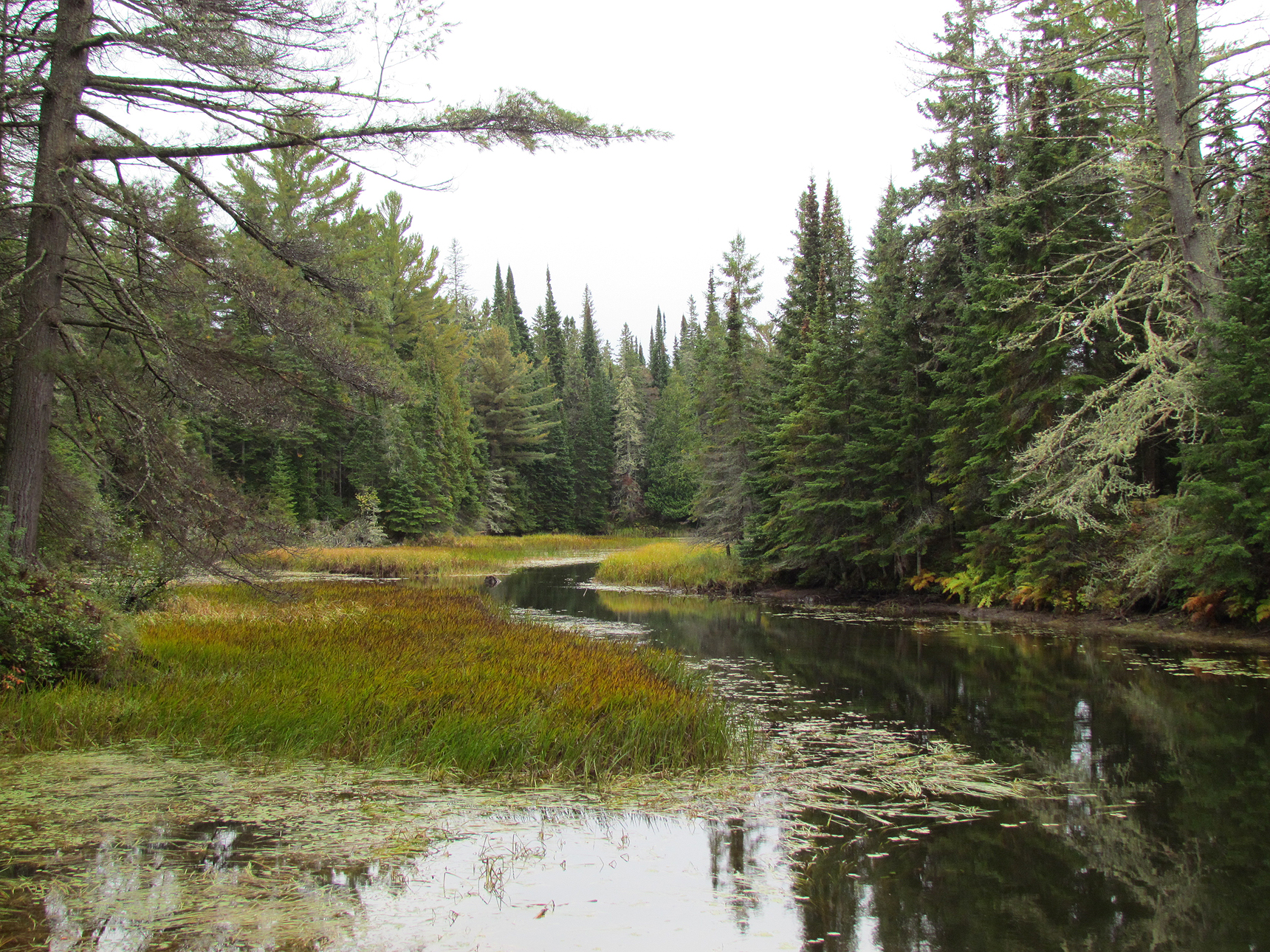
We reached the trailhead for the La Cloche Silhouette Trail just after 8:00 am. The first stretch of the hike was easy going. Though a lot of leaves have fallen, the yellows of both birch and maple lit up the area as a grey cloak of a sky hung overhead. White quartzite from the South La Cloche Range flanked us for a while and we had a few streams to negotiate.
Bridge at George Lake and the Chikanishiing River. (click image to enlarge)
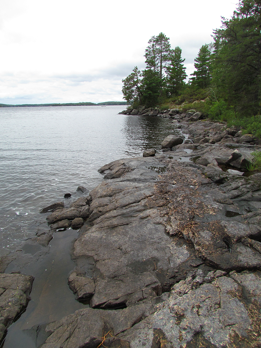
The most interesting event of the day was crossing a bridge underwater at Acid Lake, most likely due to the beaver dam nearby. Aaron was able to straddle the railing while going across, but Marianne had to take off her boots and walk across the bridge and the very cold water.
Bridge, you’re drunk…Go home. (click photo to enlarge)
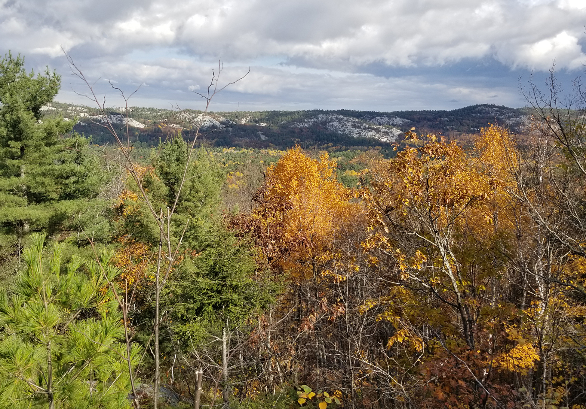
We had a few uphill sections with great views from the top before descending again. We met a few people enjoying the trail today, including those out for a few days, while others were just out for a day hike. While descending the South La Cloche Range the clouds rolled in and it started to rain graupel. I guess graupel is better than rain because the pellets just bounce off.
View of the South La Cloche Range from a lookout. (click image to enlarge)
We took a short break close to Artist Lake before arriving at the section where the portage meets the trail. We probably should’ve taken a longer break here because we were beginning to feel a little sore. While along the portage/trail section we saw that someone put up a sign warning of a paper wasp nest hanging right beside the portage. That would have been exciting if someone hit that with their canoe while portaging! We did see the wasp nest but no one appeared to be home.
View from the dock overlooking beautiful Baie Fine. (click image to enlarge)
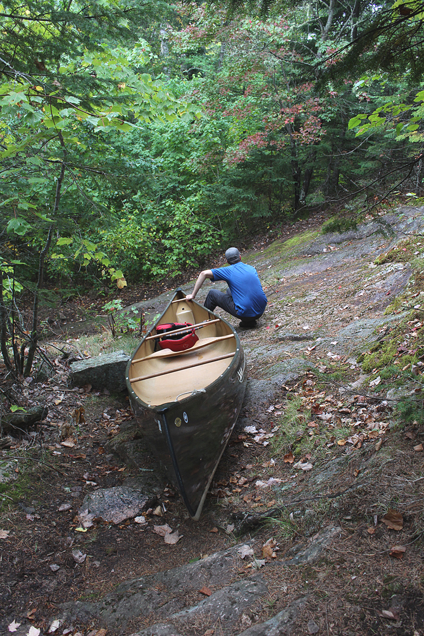
We took a detour to check out the cottage for sale at Baie Fine. The view at the lake is incredible, however the cottage, or at least from what we saw, needed some work. By this point we were starting to feel tired and sore as we began the hike up “The Pig” portage/trail. This section of the La Cloche Silhouette trail crosses into the Blue Ridge. “The Pig” section of the trail used to be a logging tote road and today it is left with some loose rocks that require you to pay attention to where you are walking.
“The Pig” used to be an old logging tote road. It has a lot of boulders. (click image to enlarge)
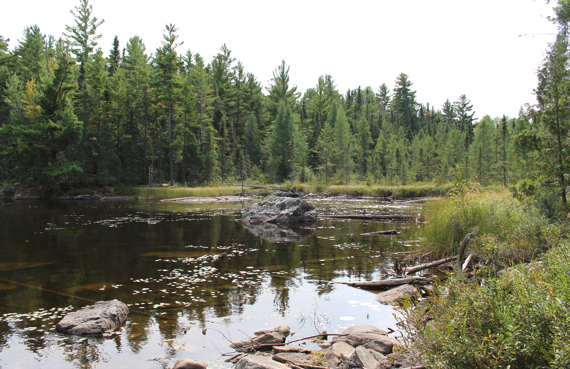
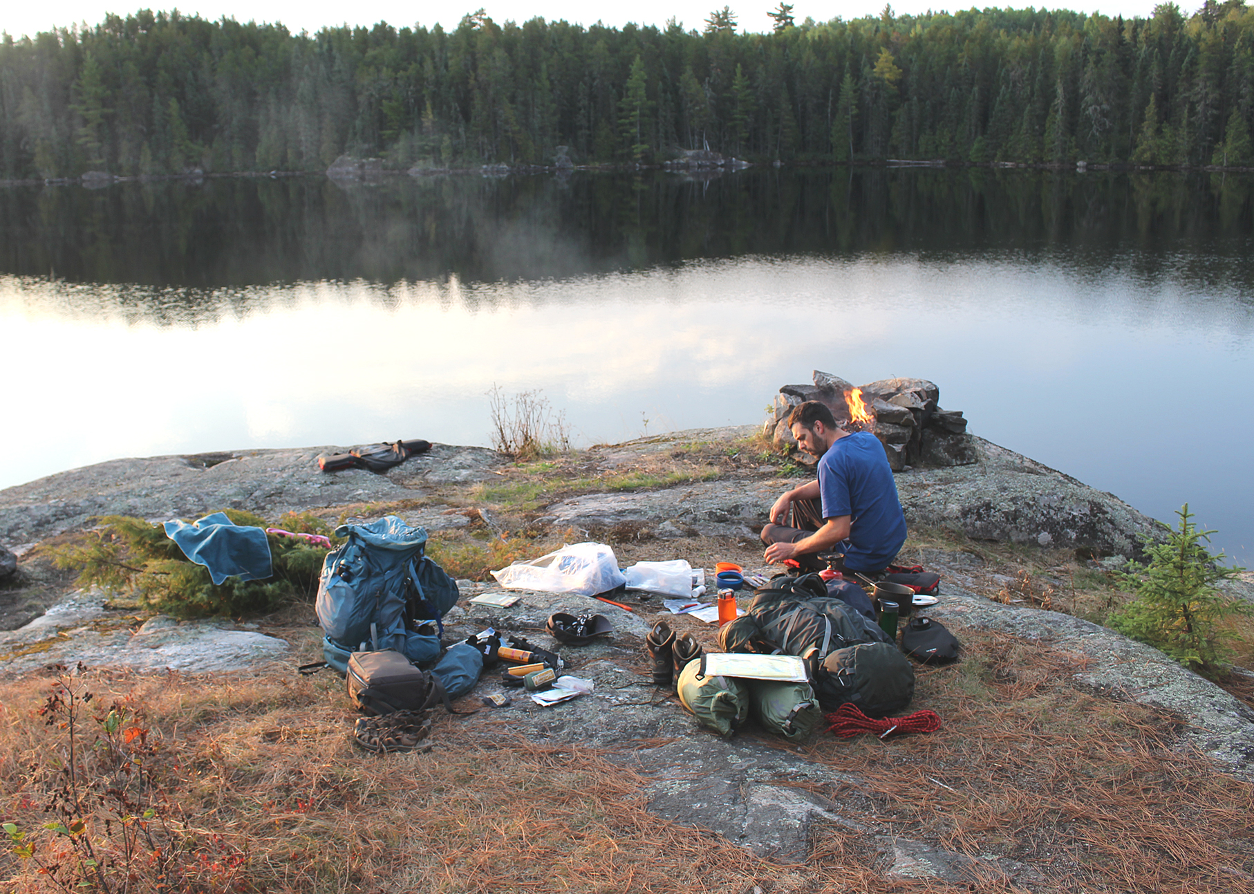
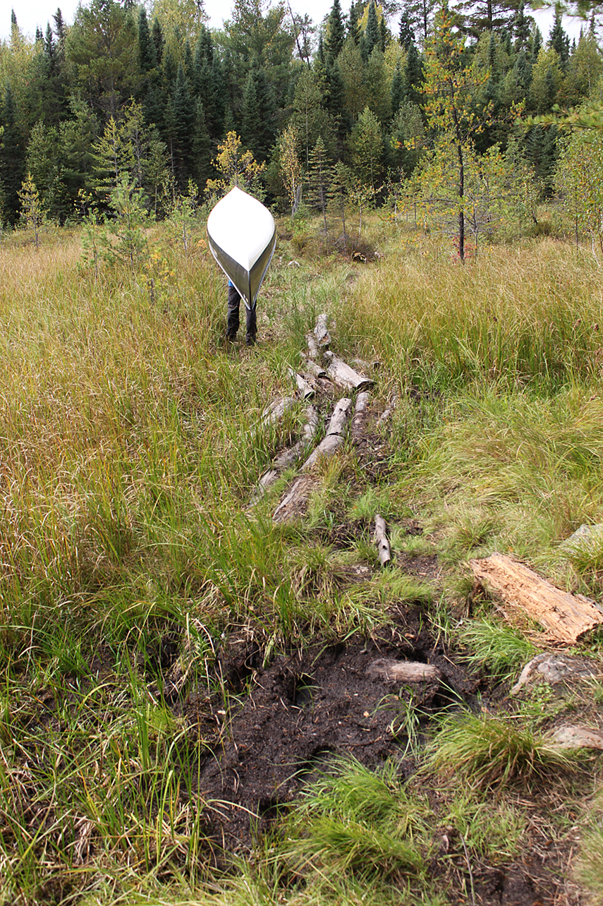
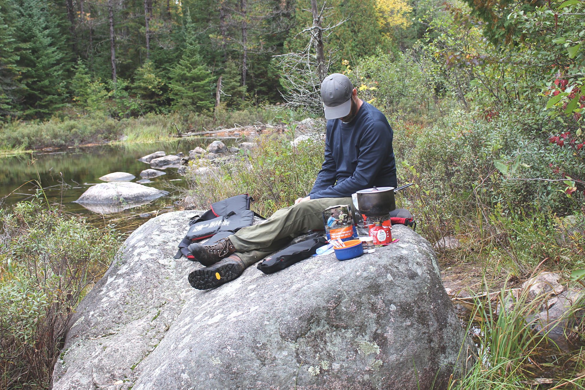
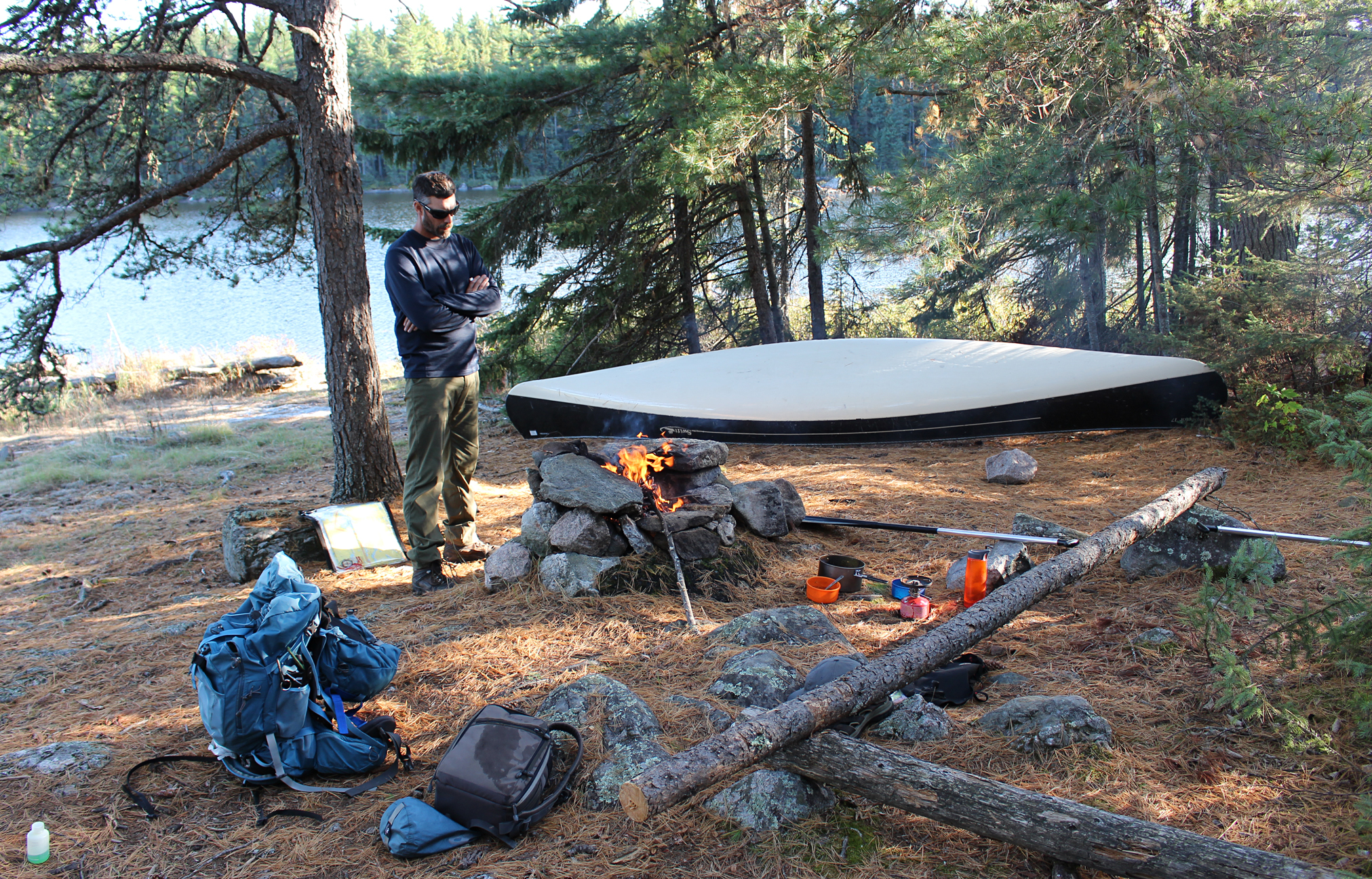
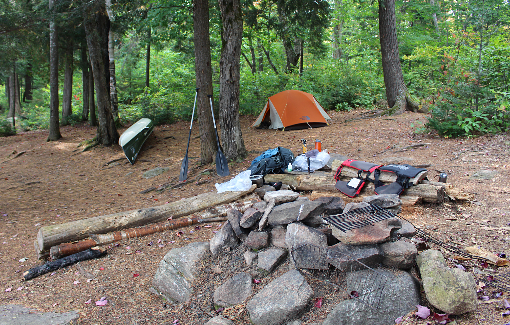
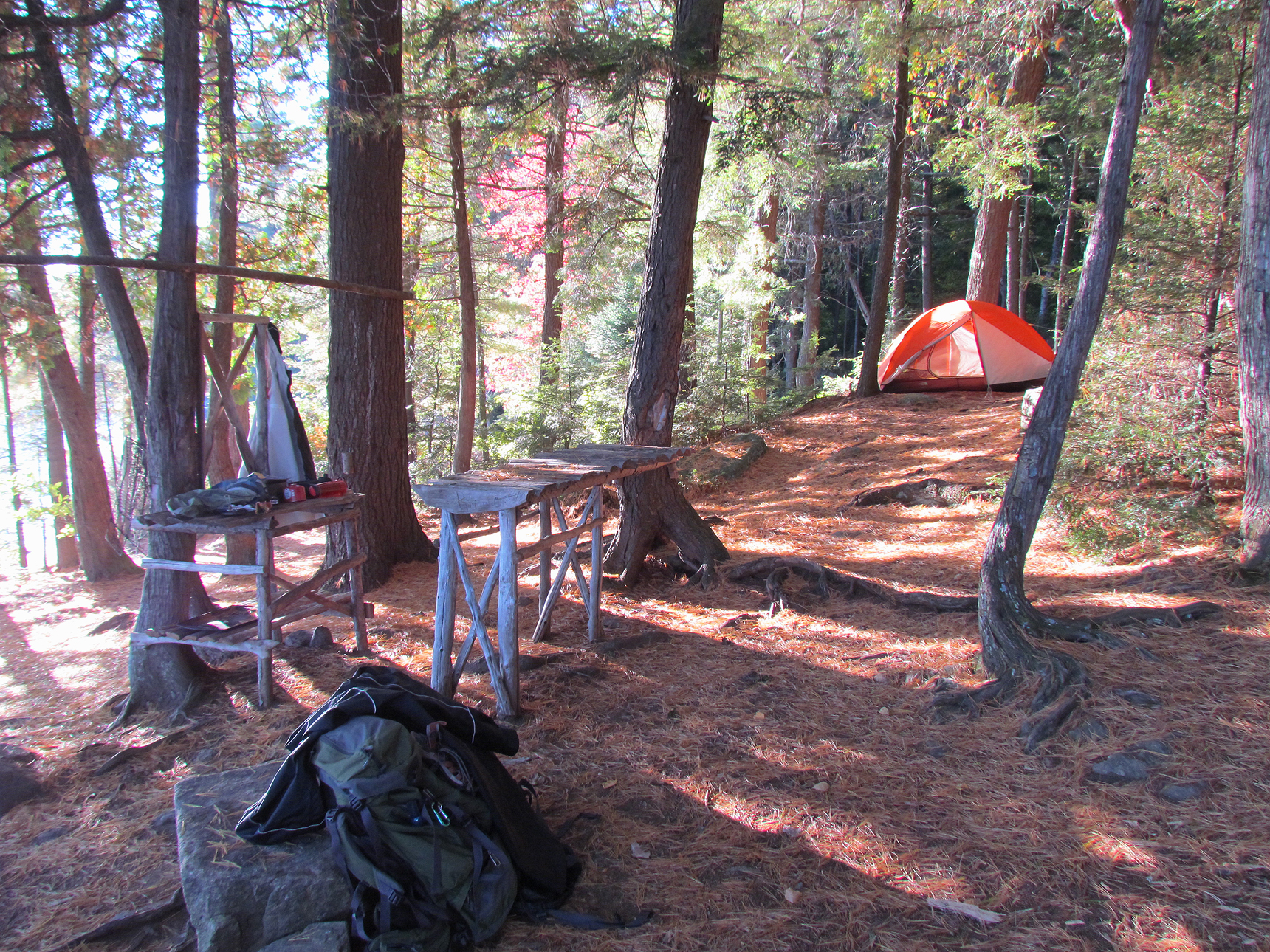
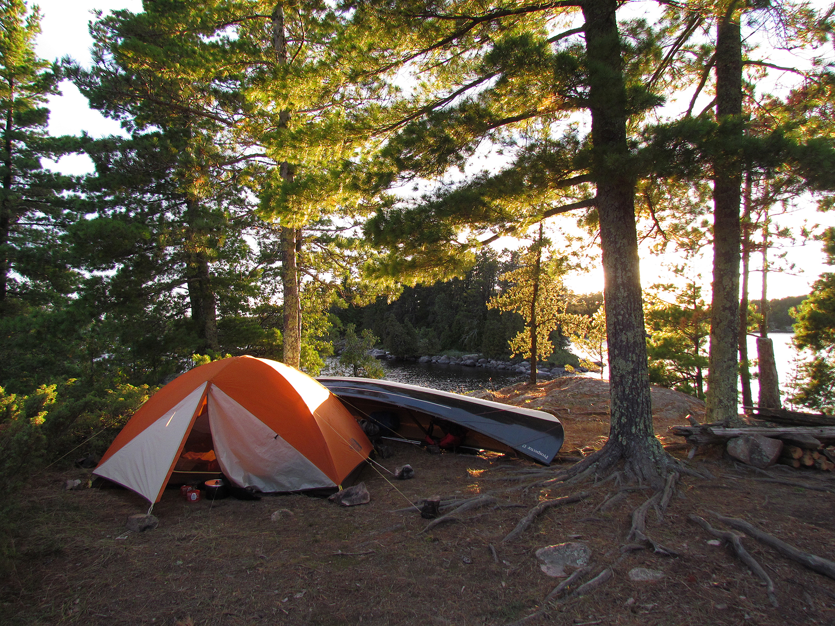
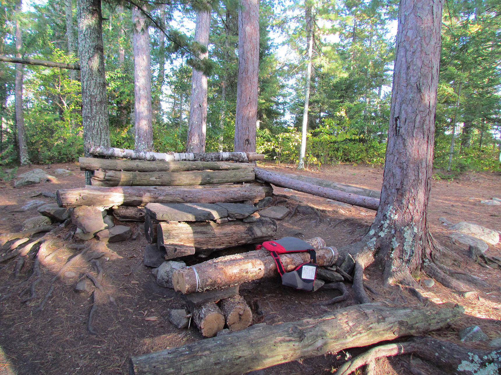
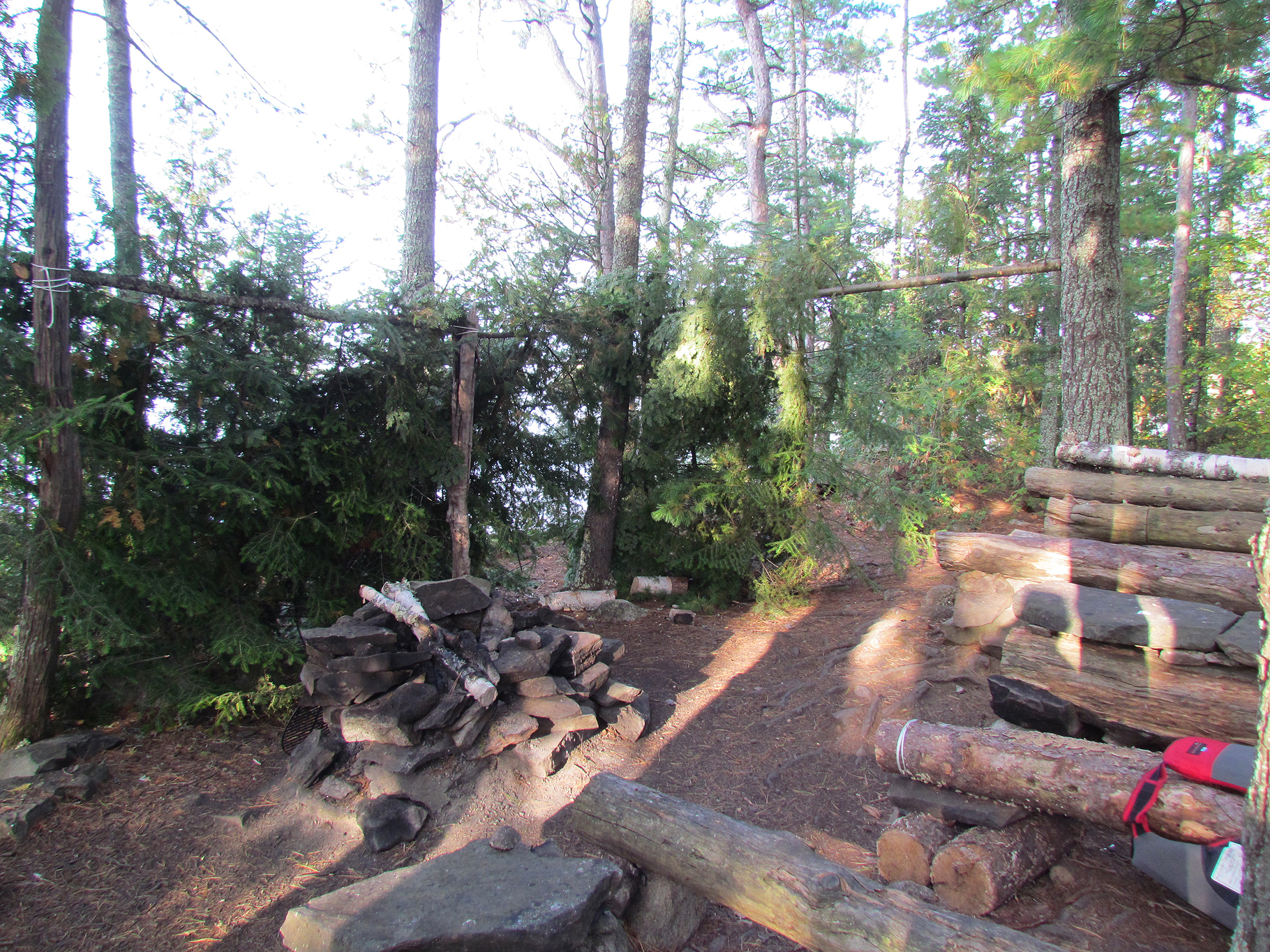
Thankfully it wasn’t long before we saw the yellow arrows on the trees that would lead us to the campsite at Topaz Lake. As we slowly hiked up we eventually found an exposed area of flat quartzite where there was a fire pit. We actually unpacked a bit as we thought we had arrived at our site but then Marianne found more yellow arrows that lead you even further into the trees. We packed up our stuff and began the descent to the real site at Topaz Lake around 2:45pm.
What we thought was the site near Topaz Lake. The trail to the real site continues where the line of trees meets the rocks in the background. (click image to enlarge)
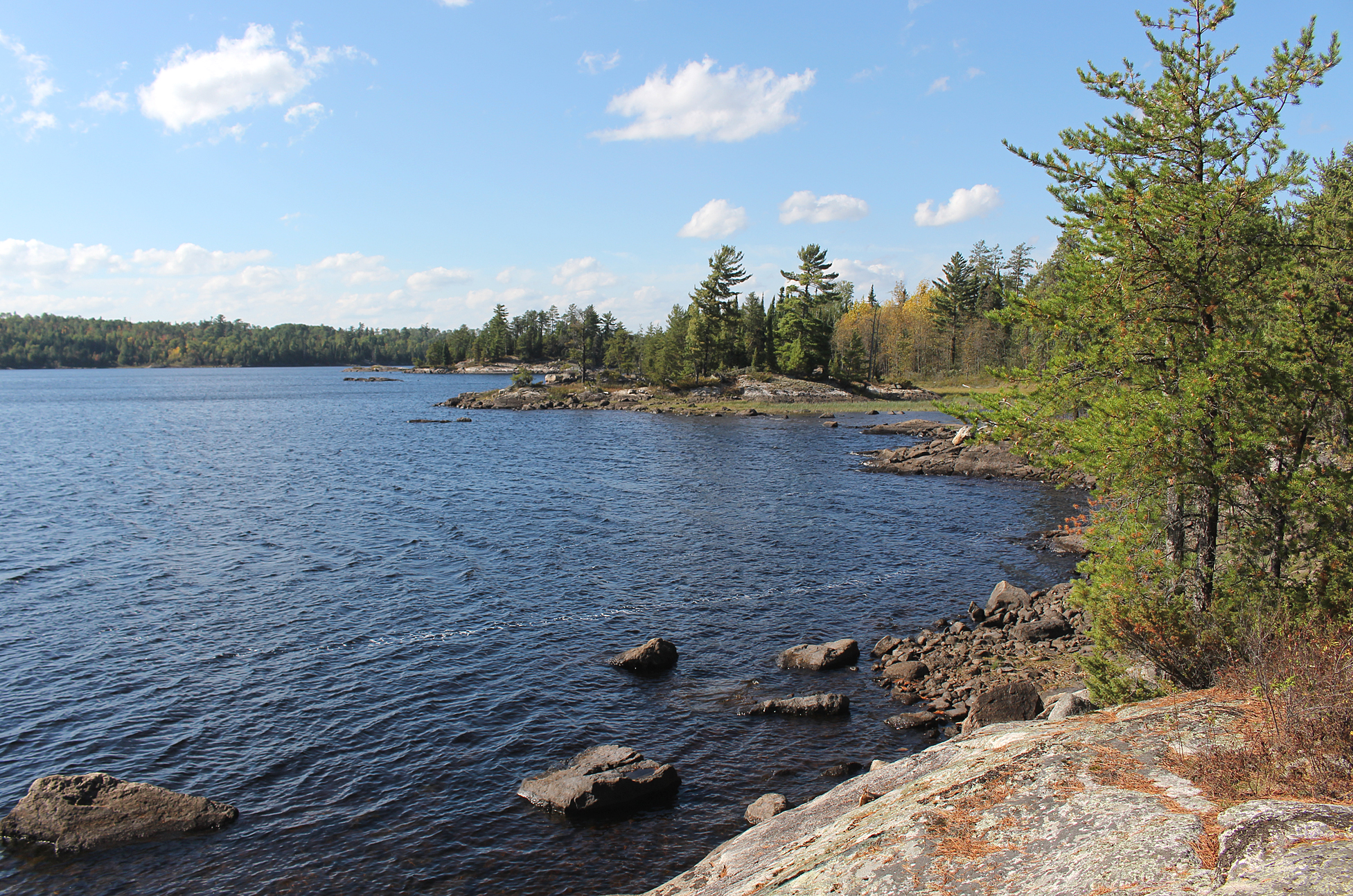
The site was pretty decent though we’ve seen better here in Killarney. There was a flat spot for a tent, a good seating area at the fire pit, but no good spot to easily get in to bath in the lake. The view of white quartzite ridges is excellent! The lake is incredibly clear, though this due to a history of acid rain.
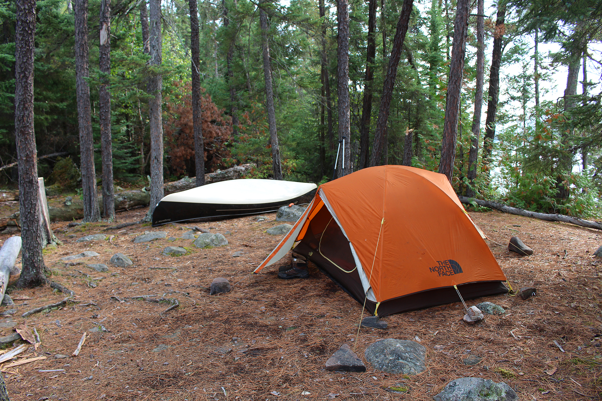
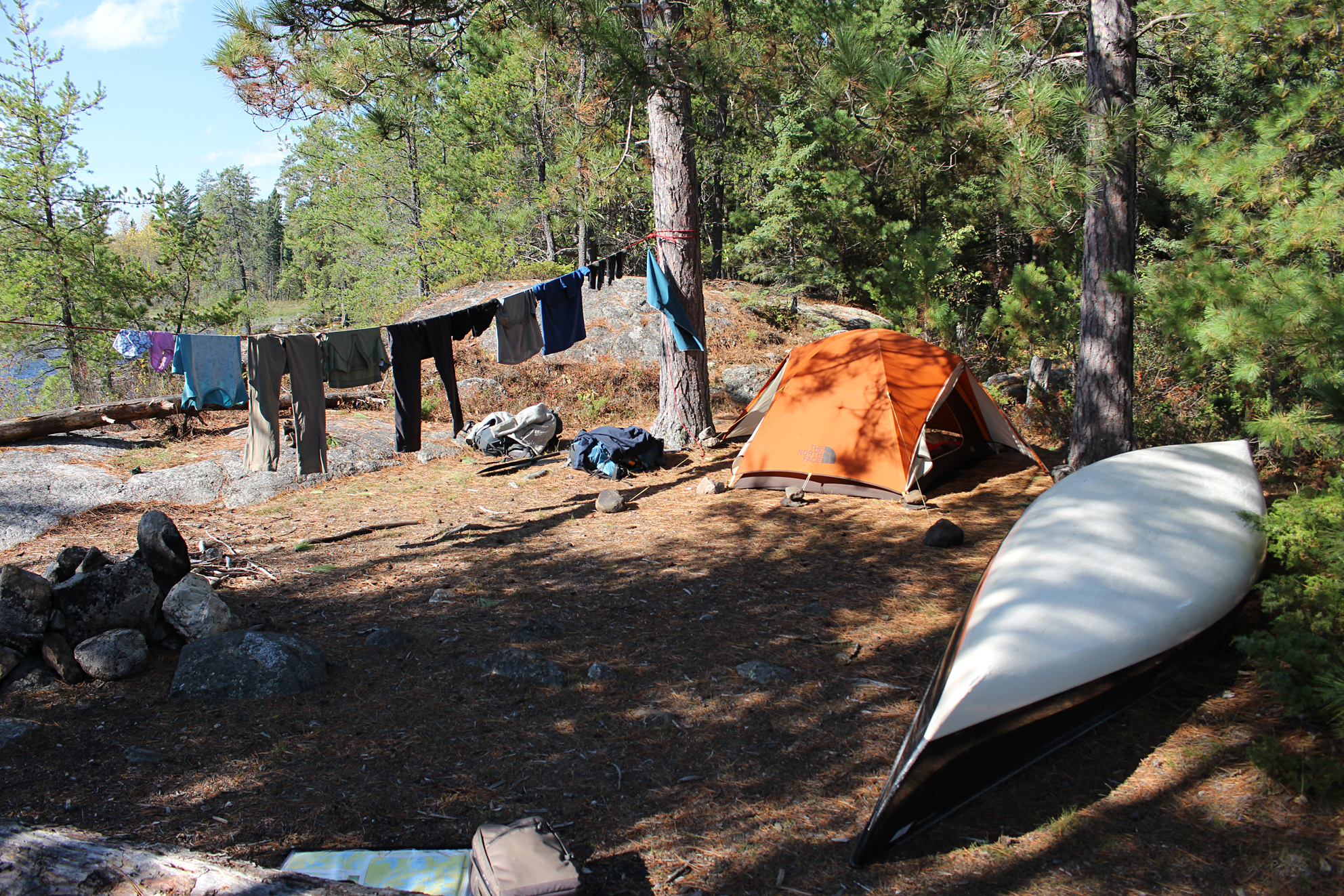
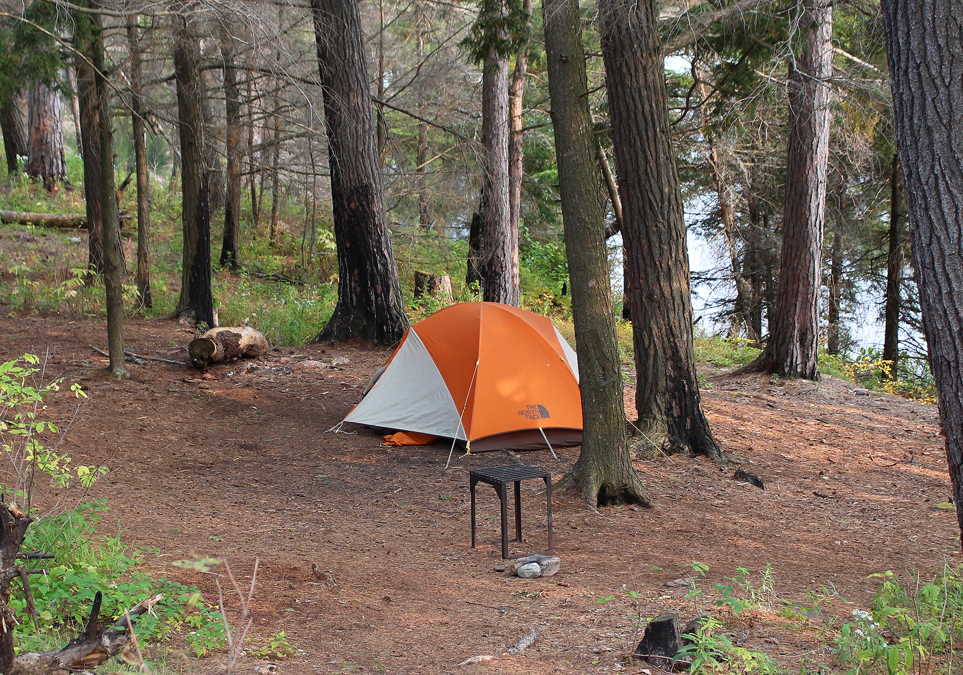
All set up at Topaz Lake. (click image to enlarge)
High levels of pH or not we needed water so we plopped our water filter into the lake and got everything all sorted out with our gear before it rained. As we hid in the tent it was nice to take off our hiking boots and just lay flat on our backs. We hiked around 9 kilometres today and Aaron in particular was sore. Tomorrow we have a scheduled 13 kilometre hike. Besides hiking the rest of The Pig it should be a lot flatter as we enter the Kirk Creek section. Both rain and wind is forecasted for tomorrow with tonight being especially windy. Hope we have a good sleep.
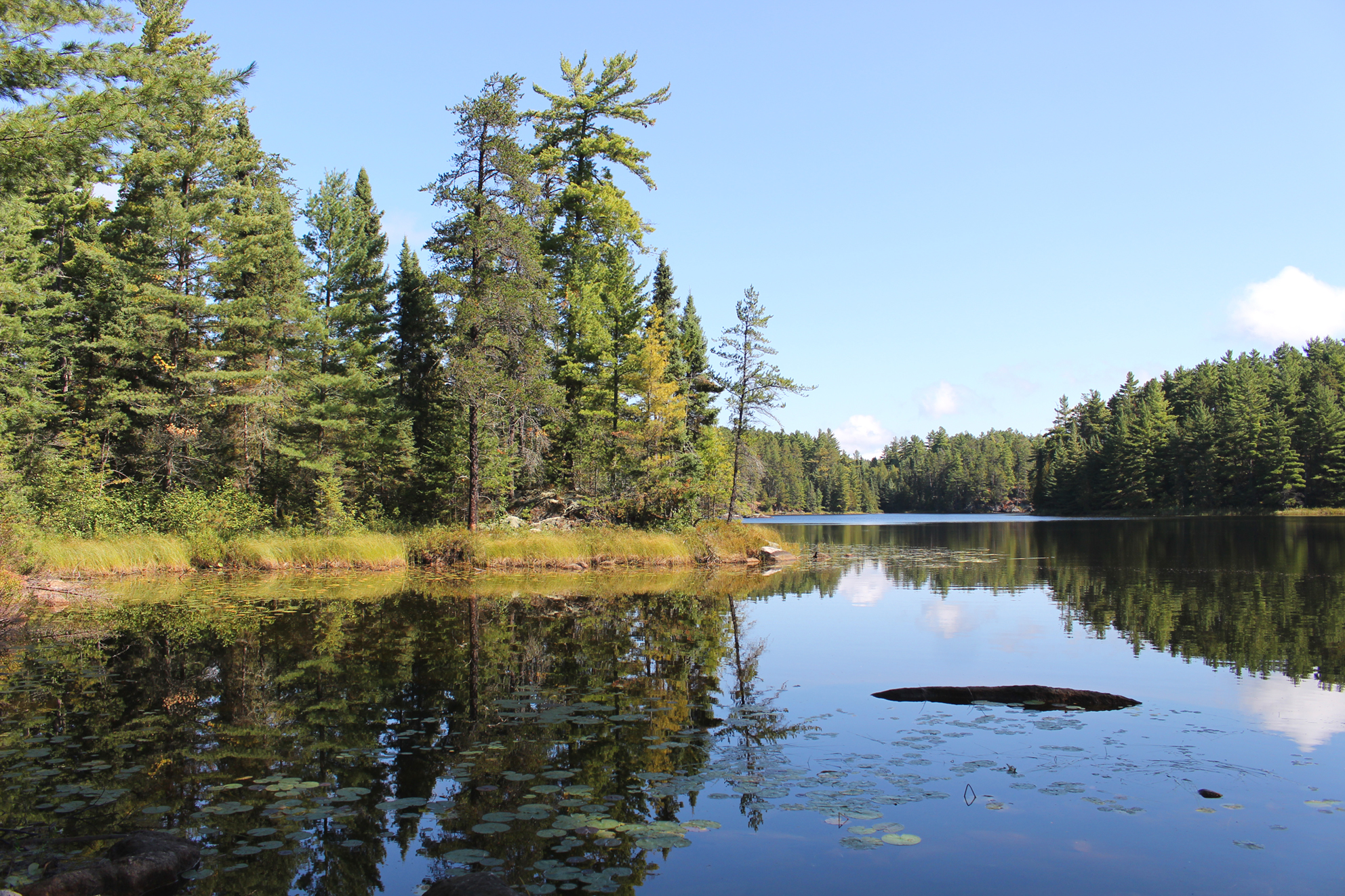
Just one of the views from our site of the beautiful Topaz Lake. (click image to enlarge)
Wildlife Sightings: Red Squirrel, Ruffed Grouse, Black-capped Chickadee, Hairy Woodpecker, Common Raven, Dark-eyed Junco, Swamp Sparrow, 10 people.
Weather: Rain and wind in the morning with rain for most of the day. High: 8 Celsius Low: 5 Celsius
topoView USGS. (click image to enlarge)
During the night we woke up to strong winds and some rain. We were very lucky that our site was completely sheltered down in our little hole at Topaz Lake. In the early morning we even heard a tree fall far in the distance. Anyone camping at an exposed site must’ve had one hell of a sleepless night!
When the alarm went off at 6:00 am we were warm and snuggled in our sleeping bags. It was still breezy but nothing like it was hours earlier and it began to rain again. Aaron’s knee was still hurting and he said he wasn’t having any fun. Rain and wind was in the forecast and listening to the weather band there was rain pretty much in the forecast for the rest of our trip. It was decision making time. Marianne wanted to keep going but would Aaron’s knee get worse? Would it be fun to hike in the constant rain, have no fire, always keep our raingear on, watching every step we take so as not to slip on the white quartzite? Would it be all worth it just to say that we completed the La Cloche Silhouette Trail even though it may not be fun?
All bundled up nice in warm in the tent. (click image to enlarge)
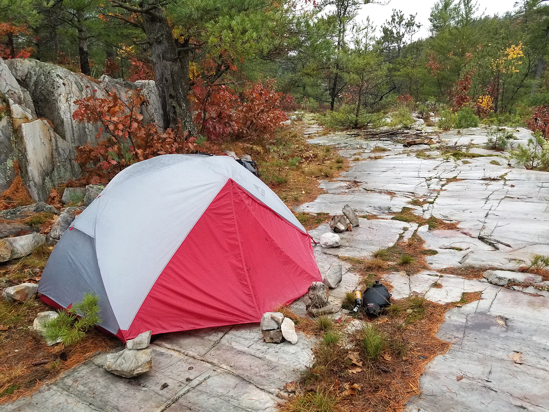
In the end Marianne came up with a compromise. We couldn’t/shouldn’t hike out today with Aaron’s knee hurting, plus the wind and rain would make it a miserable hike. We would pack up around noon, hike up to that spot we thought was our site the day before, and try to find a flat sheltered area to set up the tent. There was no way we could stay here for another day as we knew the site was booked for another group coming in. After today we were to hike out…defeated yet again. Man 2020 can you crap on us anymore than you already have?
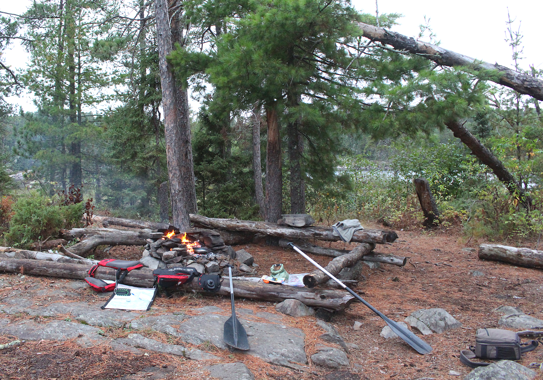
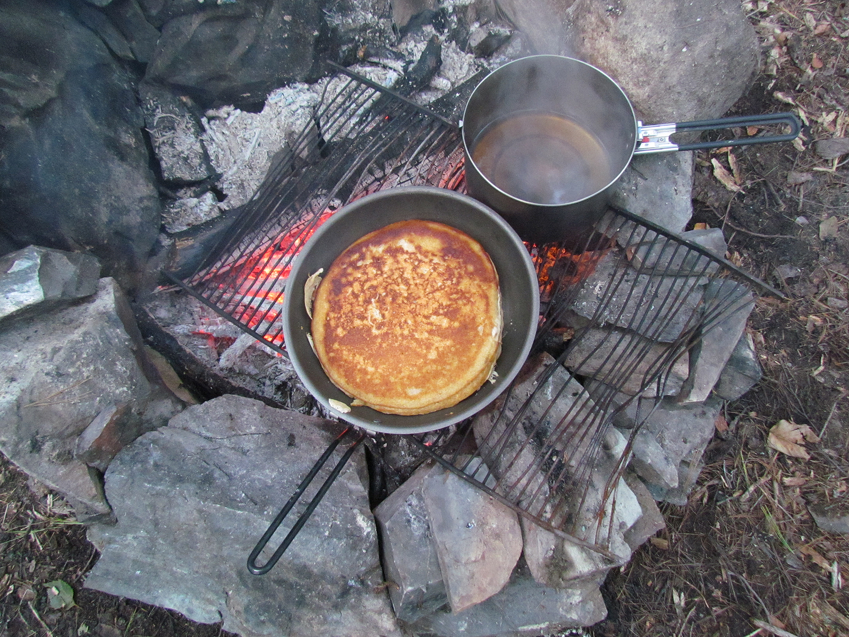
For breakfast we had a big bowl of oatmeal with rehydrated apples, strawberries, and walnuts and brown sugar on top. Because we had no morale tea we had hot water with a dash of brown sugar, which wasn’t bad though nothing to brag about. Luckily the rain stopped long enough for us to enjoy our breakfast outside and continued that way for most of the morning as we chilled around the seating area at the fire pit. For lunch we tried a new freeze-dried meal, Alpine Aire Sweet Potato with Chicken and Rice. It was an okay meal, at best getting a 6.5 out of 10 on the “Aaron and Marianne Tasty metre.”
Around noon it began to rain as we broke camp and hiked out until we arrived at a flat spot of quartzite to set up the tent. Though the area was more exposed we did manage to find somewhat of a shelter spot with a rock behind us. We set up the tent in the rain, threw our stuff inside, and hid in the tent. Around 3:00 pm the expected individuals that reserved the Topaz Lake site hiked by our tent. We didn’t even bother to get out and say hello as it was still raining. They probably weren’t up for a visit either being so close to arriving at the site.
The new location of our tent on quartzite on the trail to Topaz Lake. (click image to Enlarge)
No fire or even the use of our camp stove for supper tonight. When the rain let up a bit we went out of the tent and grabbed some snacks out of our packs such as a Meat Bar, GORP and a Honey Stinger Cracker Bar. As dark approached we hung our headlamps up in the tent and played cards (war) while listening to CBC radio. No point in listening to the weather band….We already knew a chance of rain was in the forecast for tomorrow, and the next day, and the next day, and the next day….
Wildlife Sightings: Red Squirrel, Bald Eagle, Black-capped Chickadee, People.
Remember to: Waterproof the corners of the tent. A tiny bit of water is getting in.
Day # 3: Topaz Lake to George Lake Campground
Weather: Sunny in the morning giving way to mostly cloudy with light mist in the afternoon. High: 7 Celsius Low: 0 Celsius
topoView USGS. (click image to enlarge)
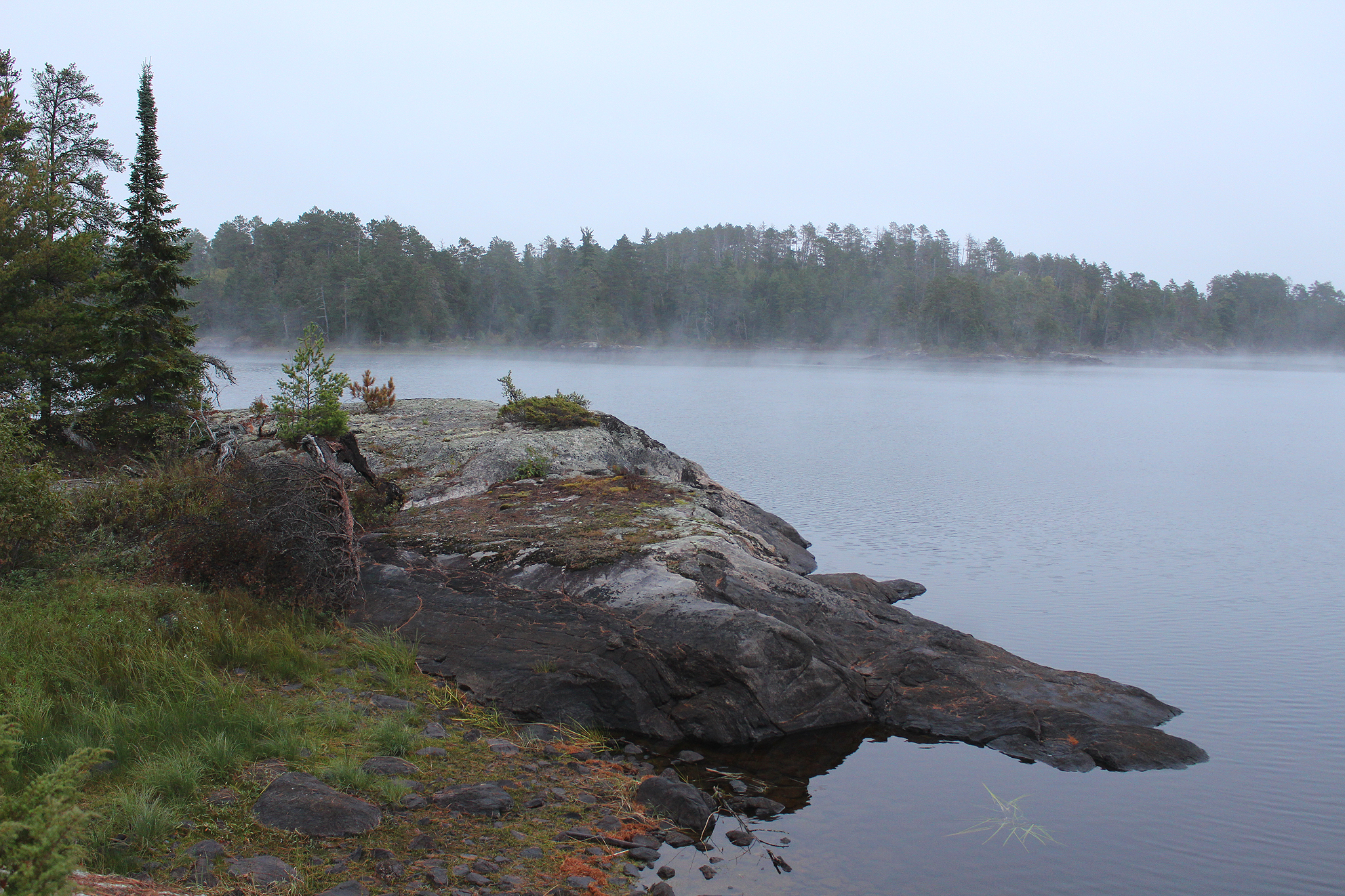
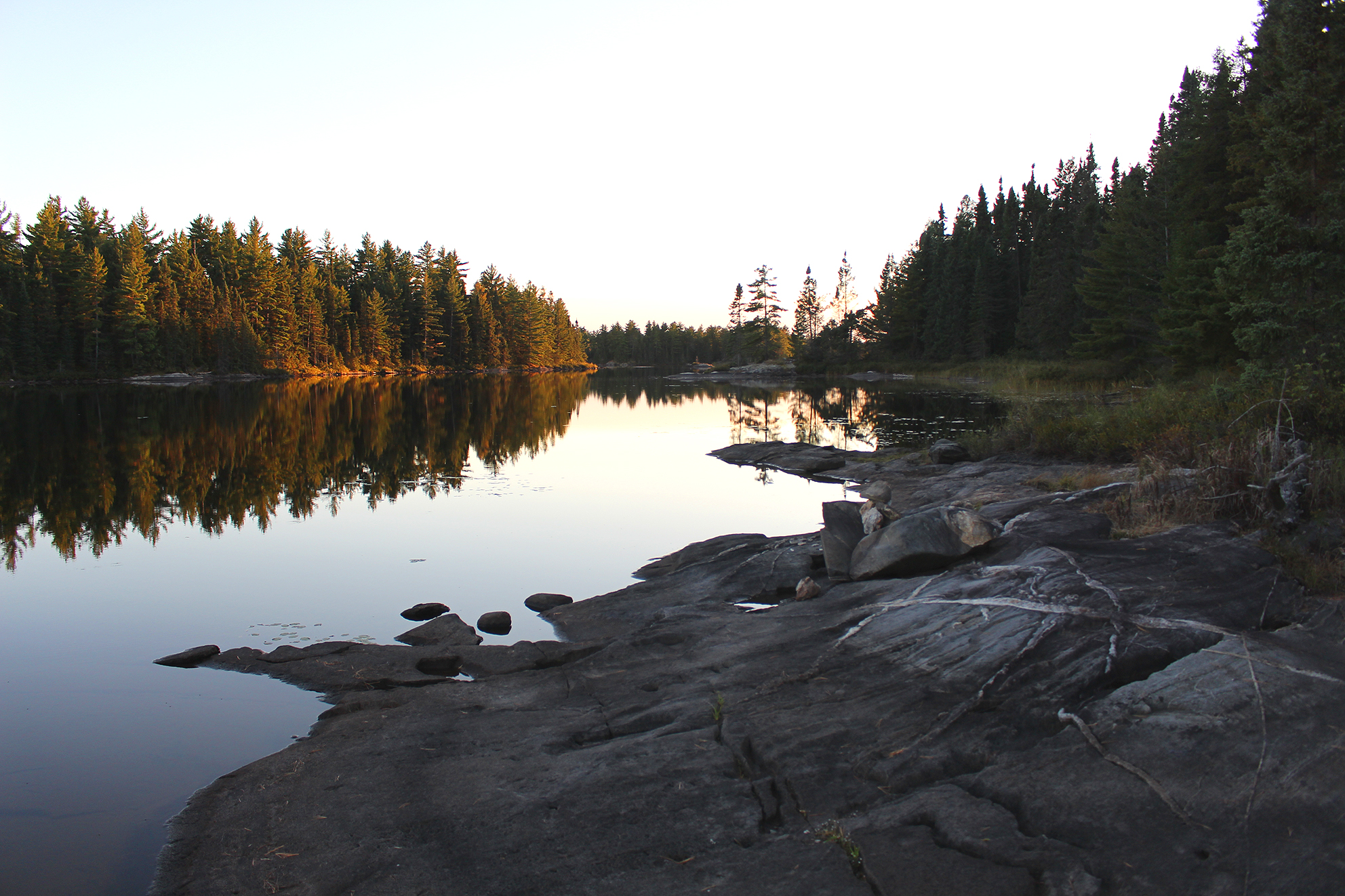
We slept okay for the most part last night on the trail to to Topaz Lake. We also must have camped on the trail used by the local wildlife as we heard critters walk beside the tent last night. The most thrilling of these visitors was just after 6:00 am. It was still dark and Marianne heard something large go by the tent. It definitely wasn’t a bear as it sounded light on it’s feet. Perhaps a deer? This was proceeded by a low howl and what sounded like two more visitors arriving shortly there after who whimpered and even growled….Wolves! This made us freeze while our hearts were pounding wildly!! As quickly as they arrived to see what was up with this thing on their trail, they were gone. We probably set up our tent along their nightly route leaving them baffled as to why there was a tent with a weird smell coming out of it. After about 15 minutes or so we turned on our head lamps, got dressed, and got out of the tent to grab food for breakfast. It was a bit cloudy out and there was even frost on the nearby trees. What was neat was that we appeared to be above the clouds, or rather the fog that was below us on the nearby lake.
Fog below us towards Baie Fine. (click image to enlarge)
Breakfast was a hearty meal of oatmeal with apples and strawberries, along with walnuts and brown sugar on top. Hot water to drink was an added bonus as well….but morale tea woulda been a lot better!
Preparing a hearty breakfast before the hike out. (click image to enlarge)
We packed up and began our hike out but not without one last gaze from the lookout overlooking Topaz Lake. The sun came out as well which felt great on your face.
Goodbye beautiful Topaz Lake. (click image to enlarge)
Hiking down The Pig we took the detour to check out Baie Fine again and the cottage for sale.
Building near Baie Fine. (click image to enlarge)
While approaching Artist Lake we saw that someone knocked down the wasp nest and we heard the distant call of a moose. Hiking up the South La Cloche Range we began to shed layers and had an early lunch off the trail on a rock while taking in the sun. In the distance the clouds were beginning to roll in.
A brief misty rain met us towards the later half of our hike and we saw that the strong winds from a few days ago shed a lot of birch leaves, now a light carpet on the forest floor. We saw groups of people out today including a couple who were just starting their own adventure of completing the La Cloche Silhouette Trail in just 5 days. It will be a wet hike.
Part of the reason why the bridge was underwater at Acid Lake. (click image to enlarge)
When we could hear car traffic we knew that we were approaching the end of the trail, and our trip, which left us a bit depressed. Both our trips this fall have been cut short. I guess the year of 2020 can be written off as an all around crappy year. Around 3:00 pm we arrived back at the George Lake campground, loaded our gear in the car, and drove to Sudbury for the night. We planned to stop off at a few parks on the way home, maybe even do some day hikes, though with many Provincial Parks now closed for the season along with Covid-19, we just decided to drive straight home the next day.
Though we left early we did check the weather radar daily to see if the forecast was true to it’s word calling for rain in Killarney almost every day. Well it did in fact stay true to the forecast, with even a rainfall warning and light snow flurries one night. Maybe it was best to bail out early this time?
Wildlife Sightings: White-breasted Nuthatch, Black-capped Chickadee, Common Raven, Ruffed grouse, Wolf (Algonquin Wolf?), Moose (heard near Artist Lake), People, Red Squirrel.
Remember to: Hike the La Cloche Silhouette Trail again. Next time add a few more days to the itinerary while taking longer breaks during the day..
Fall colours along the Chikanishing River. (click image to enlarge)
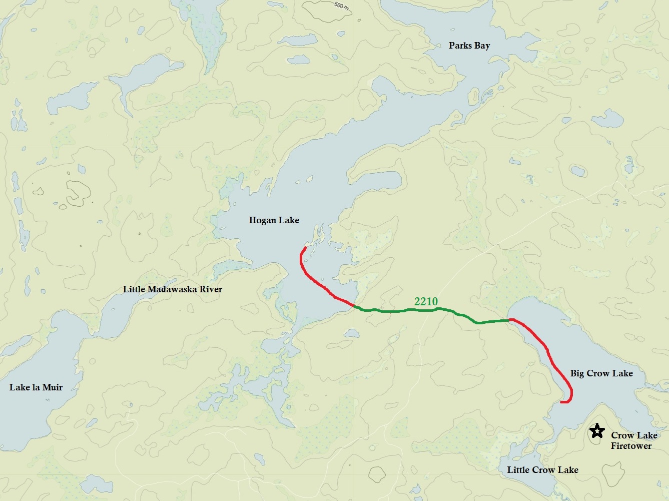
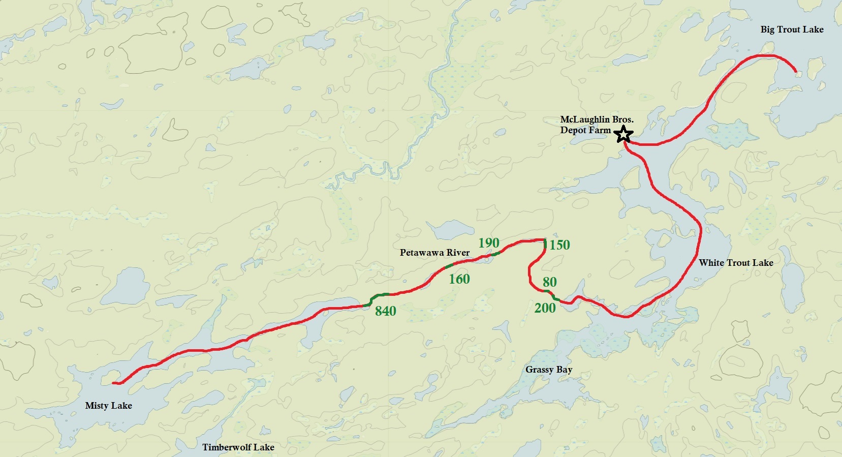
Longest Portage:2,345 metres (Unicorn Hill between Stacks Rapids and the Petawawa River)
Average Daytime High: 17.7 Celsius
Average Nighttime Low: 9.3 Celsius
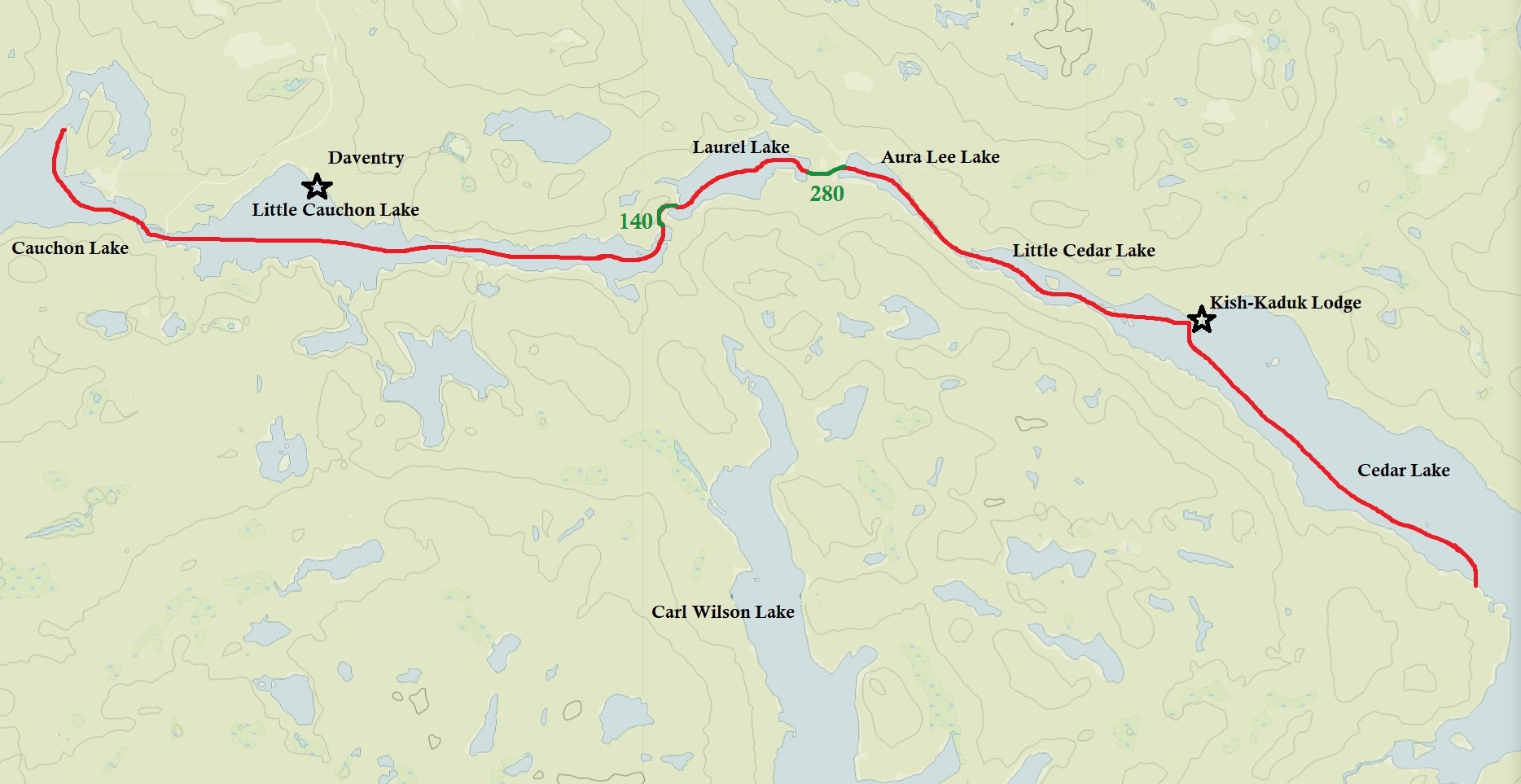
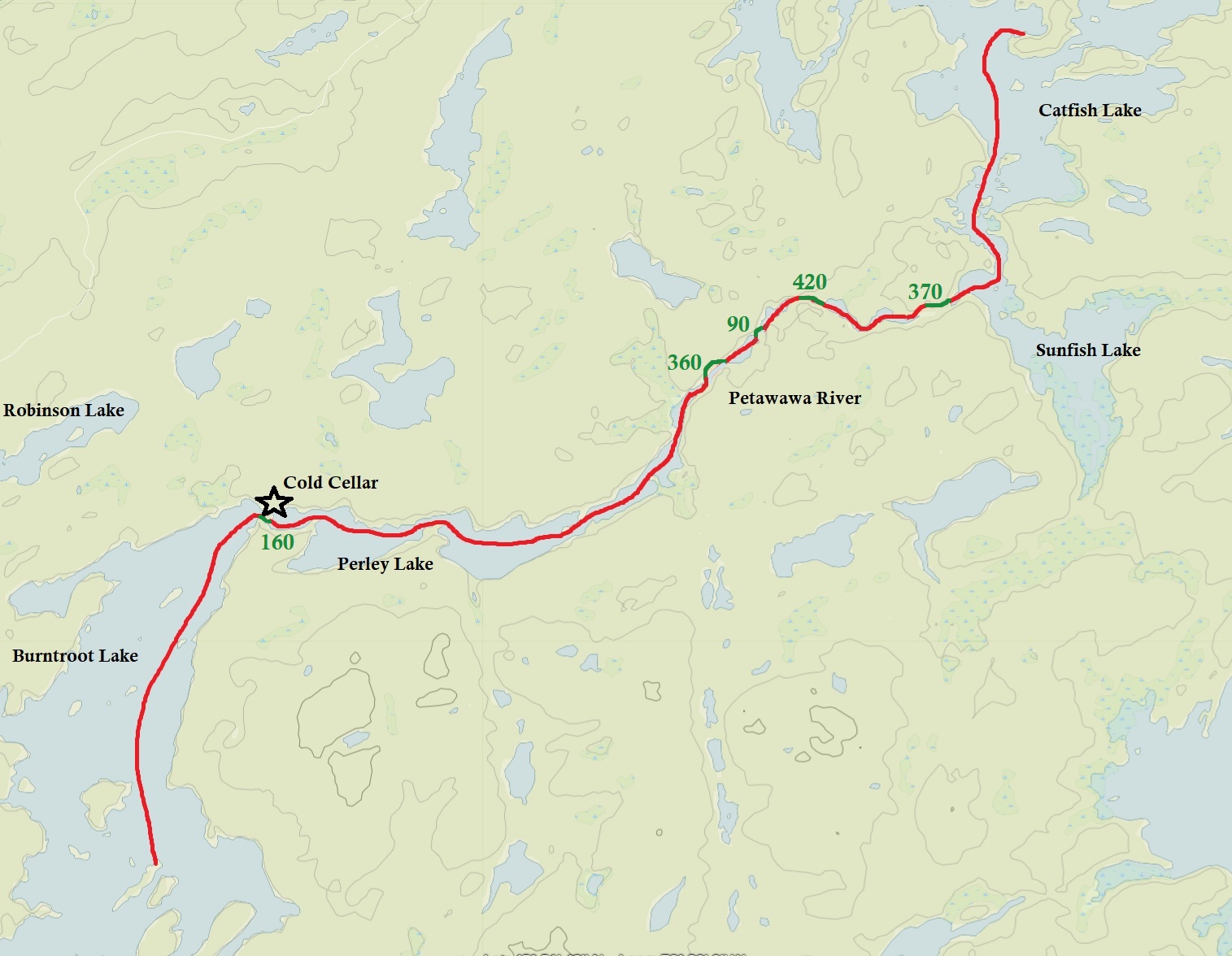
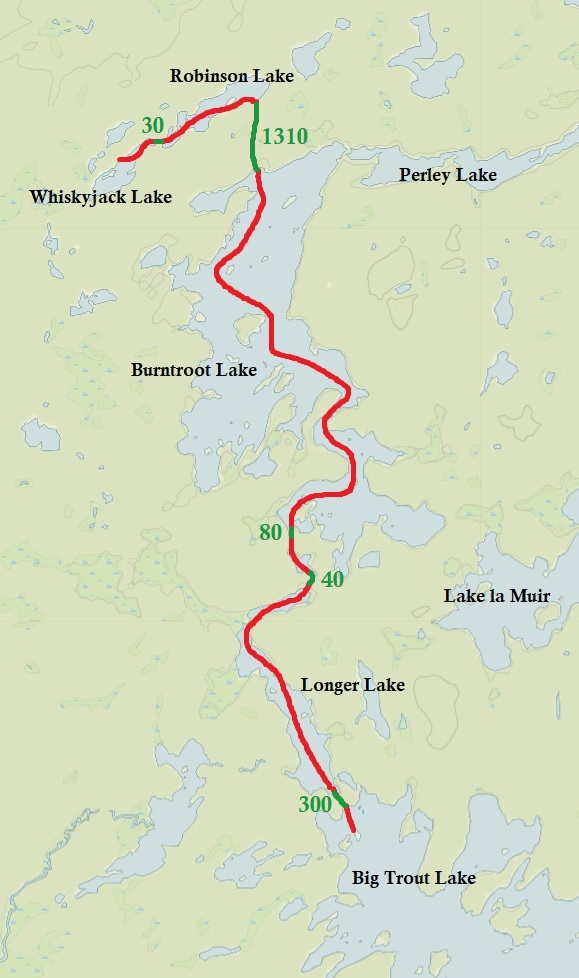
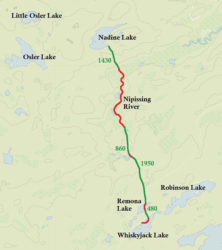
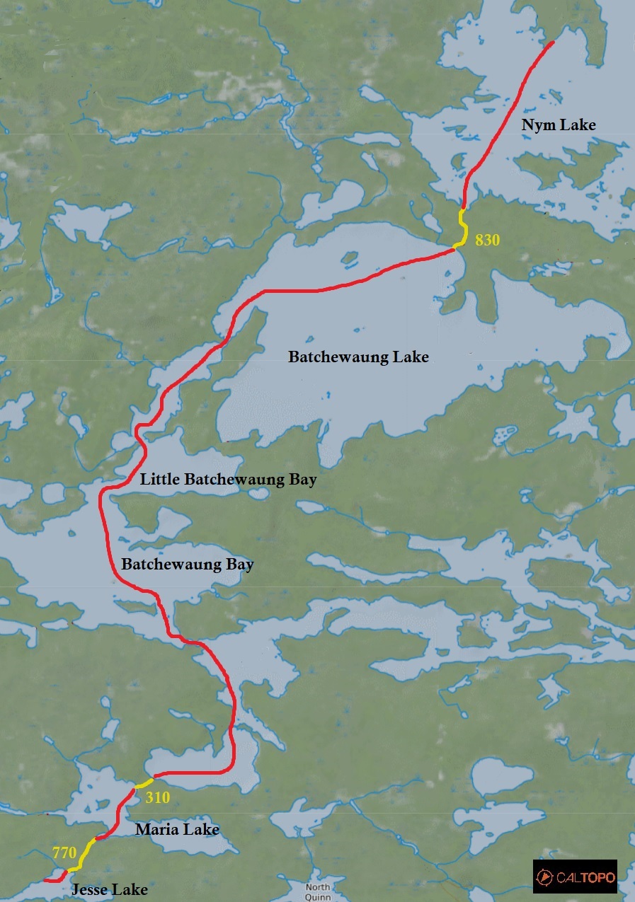
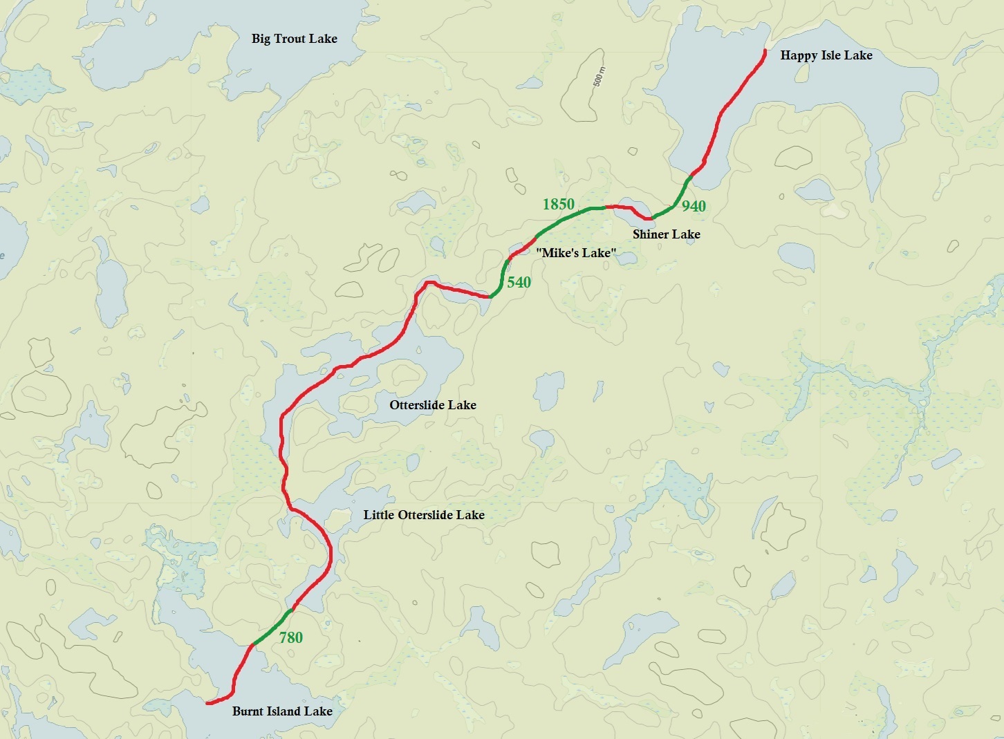
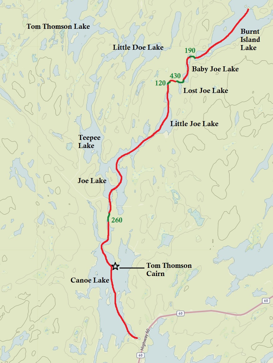
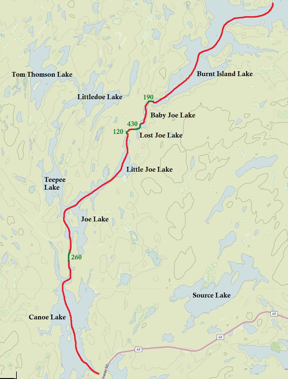
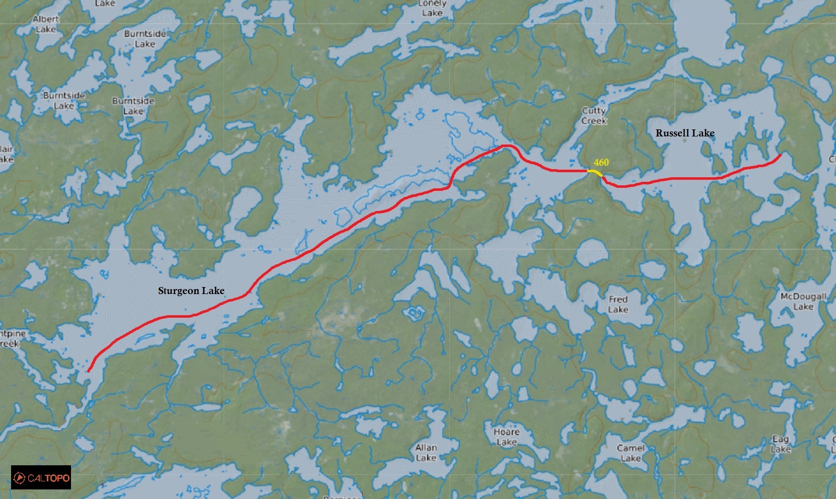
Route: Kioshkokwi Lake – Little Mink Lake – Mink Lake – Cauchon Lake – Little Cauchon Lake – Laurel Lake – Aura Lee Lake – Little Cedar Lake – Cedar Lake – Petawawa River – Narrowbag River – Catfish Lake – Petawawa River – Perley Lake – Burntroot Lake – Longer Lake – Big Trout Lake – Longer Lake – Burntroot Lake – Robinson Lake – Whiskeyjack Lake – Remona Lake – Nipissing Lake – Nadine Lake – Osler Lake – Little Osler Lake – Little Nadine Lake – Skuce Lake – Maple Creek – Erables Lake – Maple Lake – Maple Creek – Kioshkokwi Lake
Maps Used: Friends of Algonquin Park Algonquin Park Canoe Routes (2016/2017). Chrismar Adventure Map Algonquin 2 Northwest (2014). Jeff’s Map Algonquin Central (Version 5.0)
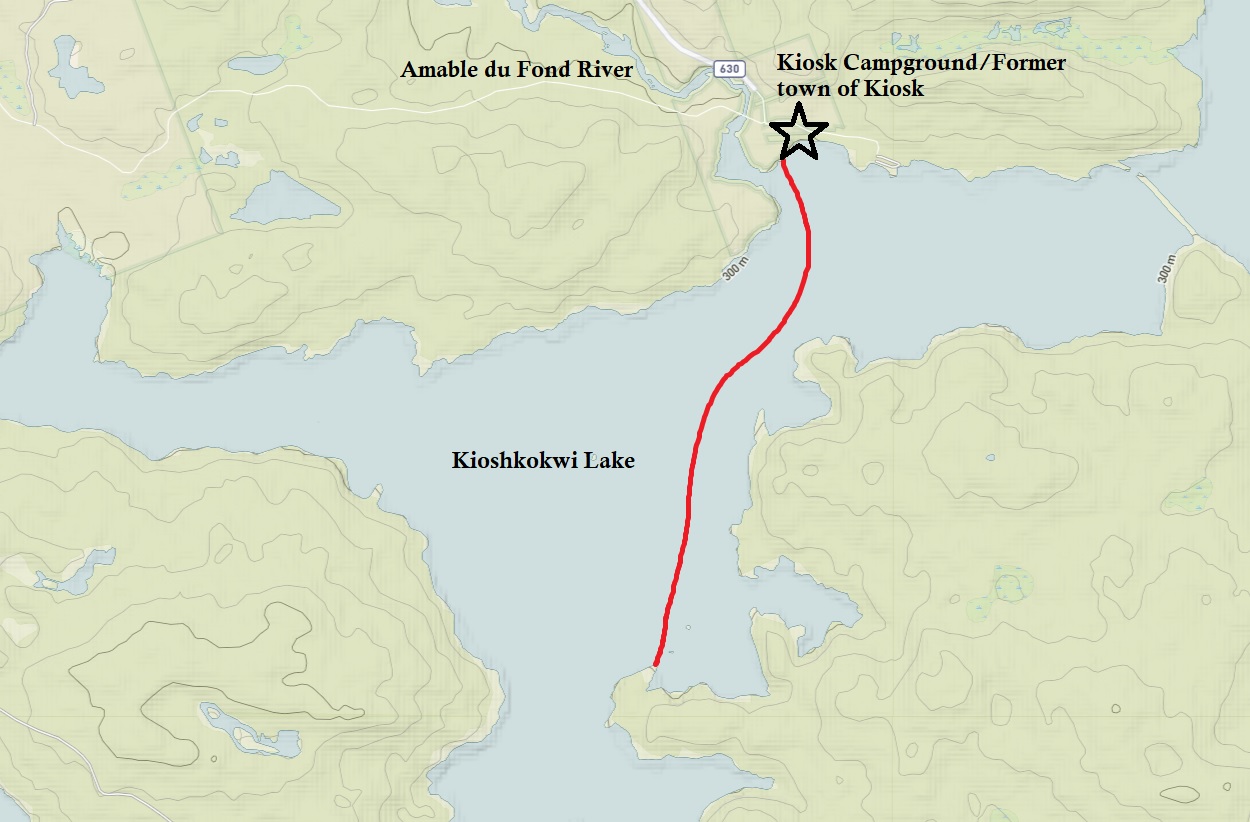
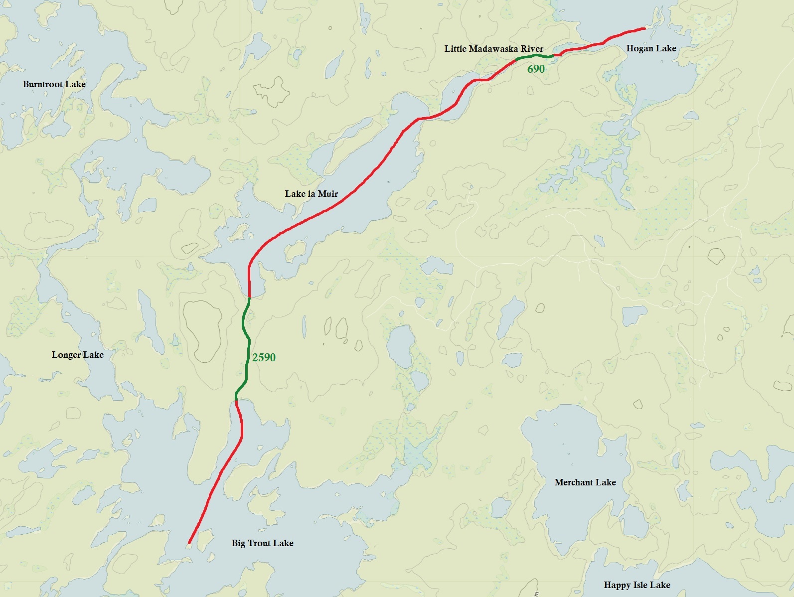
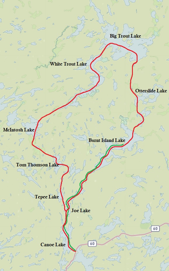
Algonquin Provincial Park with our route outlined in red. (click image to enlarge) topoView USGS.
After last year’s long drive to northwestern Ontario, we decided to stay a little closer to home for this year’s canoe trip with Algonquin Provincial Park topping the list.
The first time we ever went to Algonquin as a couple was car camping at the Achray campground in 2005. Back then we both didn’t know much about the history of the park, so for us Algonquin was a pristine wilderness in “northern Ontario”. It was a land of moose, deer, and bears. The park was an unspoiled wilderness that has been preserved since its inception…..Boy were we naïve. How about a land that also had hotels, logging camps, an airfield, farms, towns, railroads, steam powered boats, and even a POW camp during World War II? Algonquin has had a lengthy history since, and even before it’s creation back in 1893. This is a park rich in human history, and with a little bit of research before you grab your paddle you can find all sorts of relics from the past.
We chose the first two weeks of September as the days are generally still warm and the nights cool. We also decided to launch from the north end of the park, specifically Kiosk, to escape the more crowded highway 60 corridor.
DAY # 1: Drive to Kiosk campground
Weather: Cloudy with rain showers. Thunderstorms nearby in the afternoon. High: 19C Low: 14C
topoView USGS. (click image to enlarge)
After breakfast with Marianne’s sister in Orillia, we were on the road bound for Algonquin Provincial Park and the Kiosk Campground which is located off Highway #17 west of the town of Mattawa. On our way up we had to make a couple of pitstops with the first one at the Canadian Tire in Gravenhurst to get a new bail bucket and rope as we forgot ours at home, followed by lunch in Huntsville. Driving through periodic rain showers we arrived at the Kiosk campground around 2pm. Walking up to the park office to pick up our permit we noticed a sign on the door stating to bring footwear into your tent at night as something was swiping shoes…..Perhaps a raccoon?
We got our choice of the three Jump-off campsites (we chose J1), paid the balance of our reservation, and grabbed our permit and yellow garbage bag. Jump off sites at campgrounds in Algonquin are the sites exclusive to those who will be launching into the backcountry. What was nice about J1, along with the neighbouring J2, was that they were secluded from the rest of the main campground. Another luxury was that we could launch directly off our site the next day.
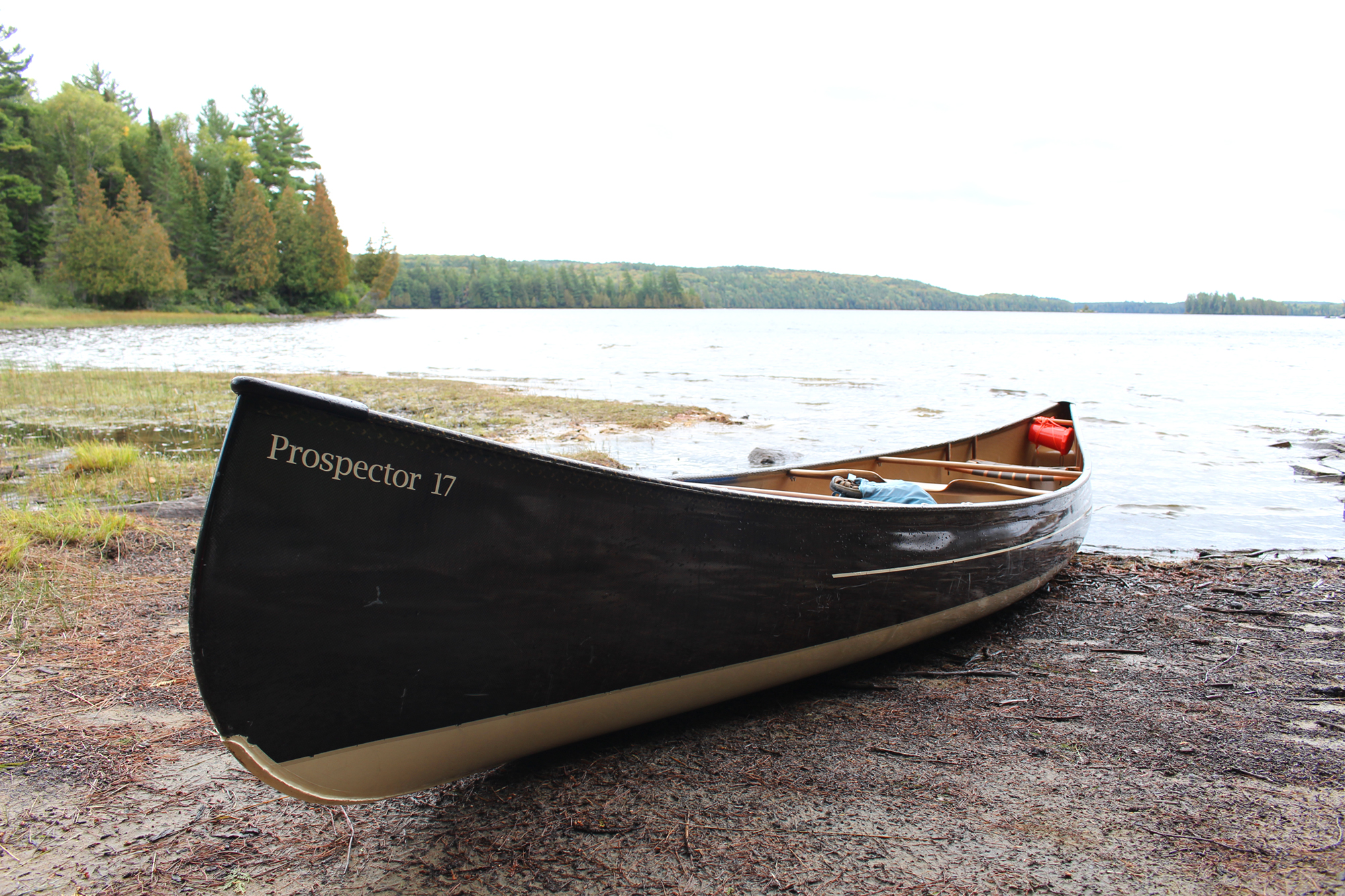
Our Jump-off site at the Kiosk Campground. The Amable Du Fond River is barely visible in this photo. (click image to enlarge)
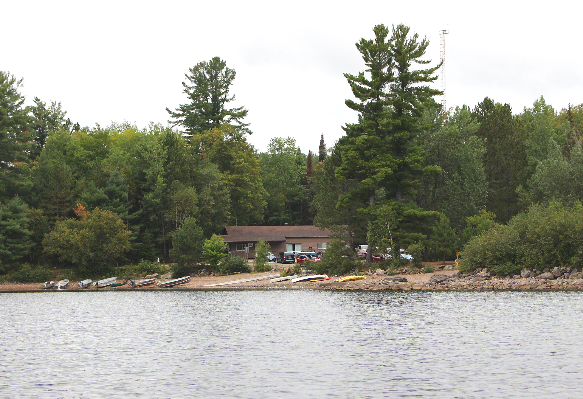
Kiosk campground is pretty neat as far as car camping goes. There are 26 sites, 3 Jump-off sites, and a ranger cabin that you can reserve as well. There are 4 vault toilets, 2 flush toilets, a water tap, a beach, and no showers. It is a really nice campground, and though it appeared fully booked it was really quiet.
After setting up the tent we crawled inside to take shelter from one more brief rain shower. There was a rumble of thunder in the area, but luckily those stayed just out of our immediate area. In the early evening we took a walk down the old CNR railway bed which, when the tracks were still in place, was last used in 1995. We walked the rail bridge over the Amable Du Fond River and saw a laneway to someone lucky enough to have a cottage on this beautiful lake.
The Amable Du Fond River beside our Jump off site. (click photo to enlarge)
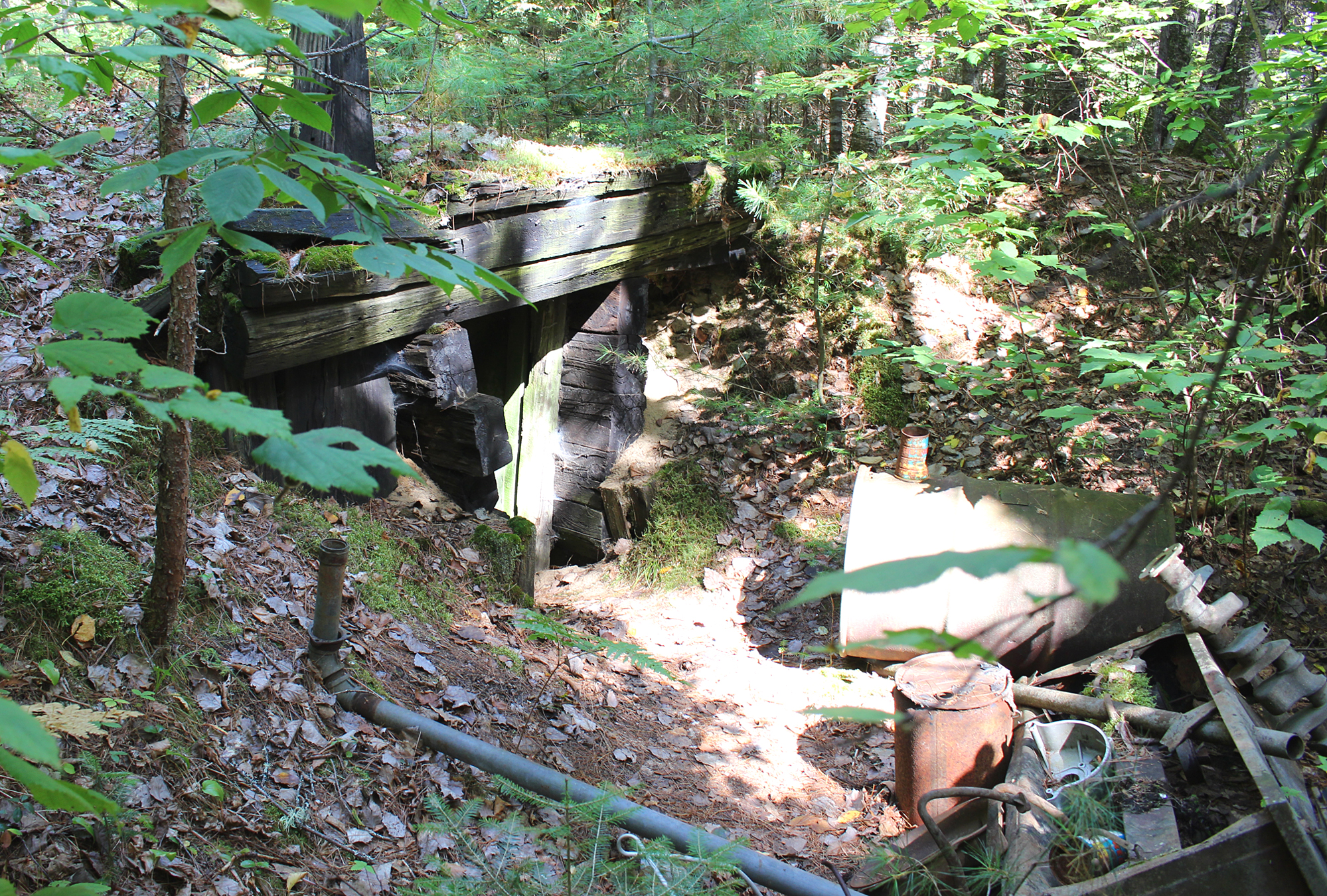
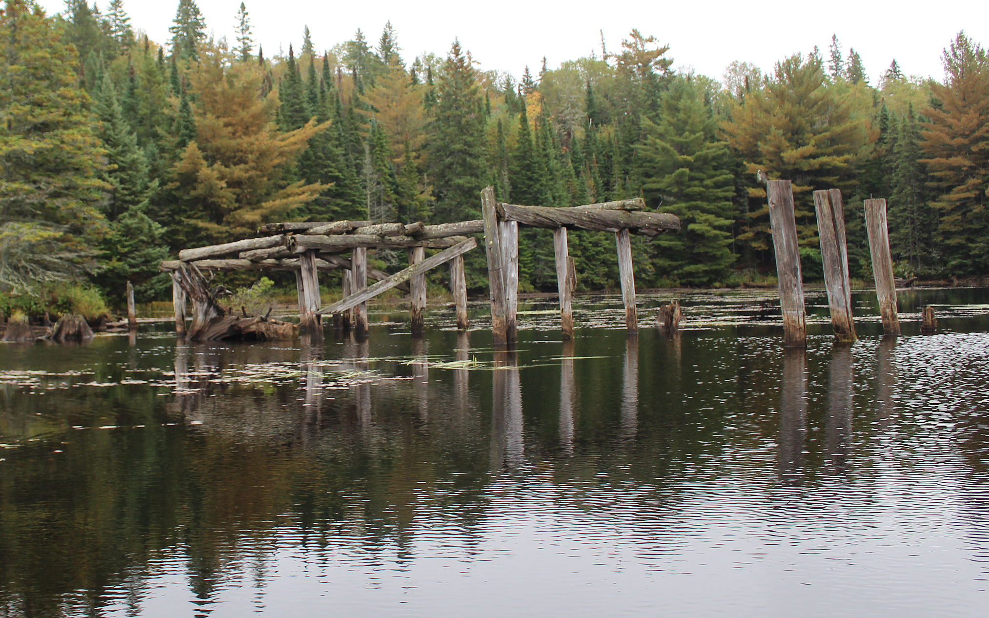
In the past the area of Kiosk was a bustling town which had a lumber mill, train station, church, and over 500 residents by the 1960s! Today there are very few signs that there was once a prosperous town here. The area was pretty much taken down in the early 1990s and later turned into the campground that we see today. From our site we saw what looked like logs barely sticking out of the lake. This could be all that was left from the Staniforth Lumber Company Mill complex which originally covered 10 acres right at the shore beside our site.
Looking out onto Kioshkokwi Lake. Those “stumps” and piles of rocks are probably remnants from the Staniforth Lumber Company MilL. (click image to enlarge)
As evening approached the anticipation of getting out in the canoe was too much and we decided to go for a paddle. As we gathered our stuff we heard a whistle being blown three times. Cold someone be in trouble? We looked around but couldn’t see any commotion so we went out onto the water and paddled towards the beach where canoes and a couple of boats with outboard motors sat. When we noticed groups of people at the beach with binoculars and scopes staring out over the water almost completely silent we knew something was definitely going on. Back at our site we later observed a boat with an outboard motor heading towards the beach towing an empty canoe. Sharing the boat with its operator were two small kids. We wondered if the kids took a canoe out on the lake and couldn’t find their way back.
The rest of our evening was spent prepping for the next day’s adventure. A few lines of Canada Geese migrated south, the first we have observed this fall. We brought our hiking boots into the tent for the night so whatever was out there stealing footwear didn’t steal our only pairs. Good thing it’s only day 1 and not 10 days worth of sweaty stinky muddy boots.
Calm evening tonight. We hoped to wake up to similar conditions tomorrow.
Wildlife Sightings: Canada Goose, Common Loon, Nashville Warbler, Red Squirrel, Song Sparrow, Herring Gull, Cedar Waxwing, People
Remember to: Add bail bucket to camping list back home
DAY # 2: Kiosk Launch to Cauchon Lake
Weather: A mix of sun and clouds, windy in the afternoon. High: 13C Low: 7C
topoView USGS. (click image to enlarge)
It was a chilly 7 Celsius when we got up this morning. Back at home in southwestern Ontario we probably haven’t had temperatures that low since the month of May. Though a bit chilly, calm conditions with no rain were with us when we launched from our Jump-off site into Kioshkokwi Lake at 8:50 am.
Paddling past the beach and the campground office at Kiosk. (click image to enlarge)
We travelled our loop clockwise as the portages for the first half of the trip would not be as demanding as the second half, and we would have lighter packs for that second half as we slowly deplete our food supply.
Kioshkokwi Lake (Kioshkokwi meaning “lake of many gulls” in Algonquin) has backcountry sites scattered along the entire lake, and though we could see that some were occupied, no one appeared to be up yet. Though we are on vacation and could sleep in if we wanted too, we usually still wake up at our usual time between 5am and 6am. We also like to get out on the water early, sometimes just at first light. Not only is the lake usually calm earlier in the morning, but we also like to arrive at our next site with ample time to relax.
While more lines of Canada Geese flew overhead announcing their leave, we paddled towards and underneath the old CNR rail bridge that had a date of 1921 carved on it. Though we would hear Canada Geese for the duration of the trip it didn’t really feel like fall yet as the leaves were barely beginning to turn. In a couple of weeks it will probably be at peak and highway 60 through the main section of the park will be a mosh pit of leafers.
A now abandoned CNR rail bridge over Lake Kioshkokwi. (click image to enlarge)
It was a bit shallow at our first portage of the trip, a 640 metre into Little Mink Lake, so Marianne got out of the canoe and dragged it over a sandbar. Here we met another couple who we would encounter on and off along portages until we exited Mink Lake.
Shallow takeout at the end of Kioshkokwi Lake. (click image to enlarge)
At the 450 metre portage out of Little Mink Lake into Mink Lake we saw a canoe on the old railbed. They probably just portaged along the railbed skipping Little Mink Lake altogether.
Mink Lake is a long and narrow lake and we paddled past a few occupied sites, though the site we stayed at back in 2010 was not one of them. That site, along with others along the eastern shoreline, used to have the train go right behind their tents until 1995. We can only imagine what that must have been like in the middle of the night.
It was on Mink Lake that the winds began to pick up, however we were lucky that it was a tailwind. Not having headwinds on your first day is a treat as it gives your arms and shoulders a chance to slowly build up some strength. The next portage, a 460 metre into Cauchon Lake was a little steep. It was around this time that the sun finally decided to make an appearance which felt really good as the temperature was only around 10 degrees Celsius.
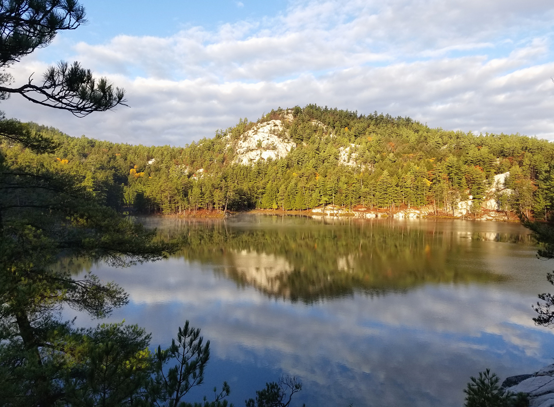
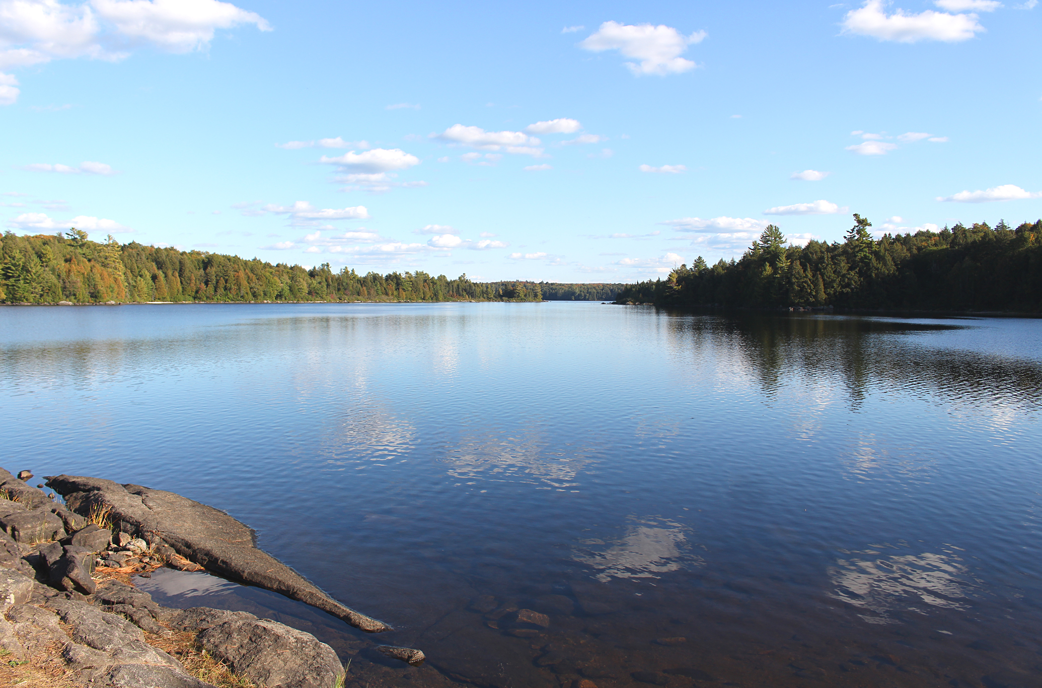
View of the rolling hills at Cauchon Lake. (click image to enlarge)
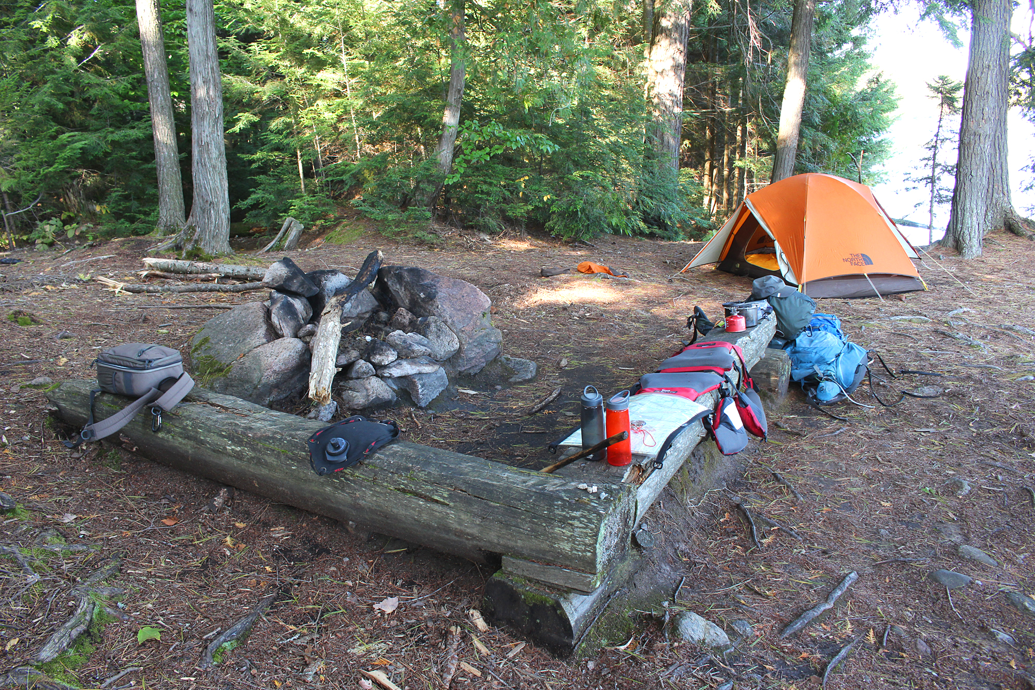
Cauchon Lake was our favourite lake for the day as it is surrounded by gently rolling hills. At 1:50pm we arrived at our site which was the furthest north in a group of 4 sites on Cauchon’s northeast shore. None of these sites were occupied. The one we chose was medium in size with an excellent seating area and firepit. A pebbly beach to launch from was appreciated, as was a nice level spot for the tent. The view from our site overlooking the lake and the surrounding rolling hills was great as well. After setting up the tent we relaxed by the firepit.
SPLASH!!!!
That sound broke the silence so we went to investigate. We looked over to the far side of our site and spotted two White-tailed Deer swimming towards the opposite shoreline. We probably unknowingly spooked them.
While Aaron had an afternoon nap, Marianne hunted around for firewood but unfortunately we didn’t gather enough for supper tonight. Perhaps we will have a small fire tomorrow morning to warm us up. We pumped water before supper to have a good supply for tomorrow. We were both tired after our first full day paddling and portaging but this is just par for the course. In a few days we will get into a rhythm and everything will seem like second nature to us.
Our site on Cauchon Lake. (click image to enlarge)
Wildlife Sightings: Herring Gull, Double-crested Cormorant, Canada Goose, Eastern Chipmunk, Red Squirrel, Common Loon, Blue Jay, Common Raven, Pileated Woodpecker, Ruffed Grouse, White-tailed Deer, People
Remember to: Do not forget the olive oil for our pancake breakfast…..our favourite food on our canoe trips may not be doable now.
DAY # 3: Cauchon Lake to Cedar Lake
Weather:Fog in the morning . Partly cloudy skies in the afternoon. High: 17C Low: 4C
topoView USGS. (click image to enlarge)
As we woke up this morning we could feel that there was a chill in the air. Winding up our weather radio last night Environment Canada stated that the low was supposed to be 3 degrees Celsius, and this morning our little thermometer stated that it was 4 degrees Celsius. We put on almost all of our layers, plus our rain gear to keep in the heat. Opening the tent we were greeted with very thick fog that enveloped the entire area. The only thing clear enough to see was that we were not going anywhere anytime soon.
Too foggy to launch. (click image to enlarge)
We gathered what we needed to make breakfast and we were happy that we saved yesterday’s wood to make a fire to help us warm up while we sipped on hot tea.
We didn’t get out onto the water until 9:20 am as we continued paddling southeast on Cauchon Lake. Paddling underneath another bridge we entered Little Cauchon Lake and made our way to the old rail station of Daventry. Today all that remains of Daventry is a few cottages that can only be accessed by a logging road south of the Brain Lake access point.
Abandoned rail bridge with beaver dam liftover. (click image to enlarge)
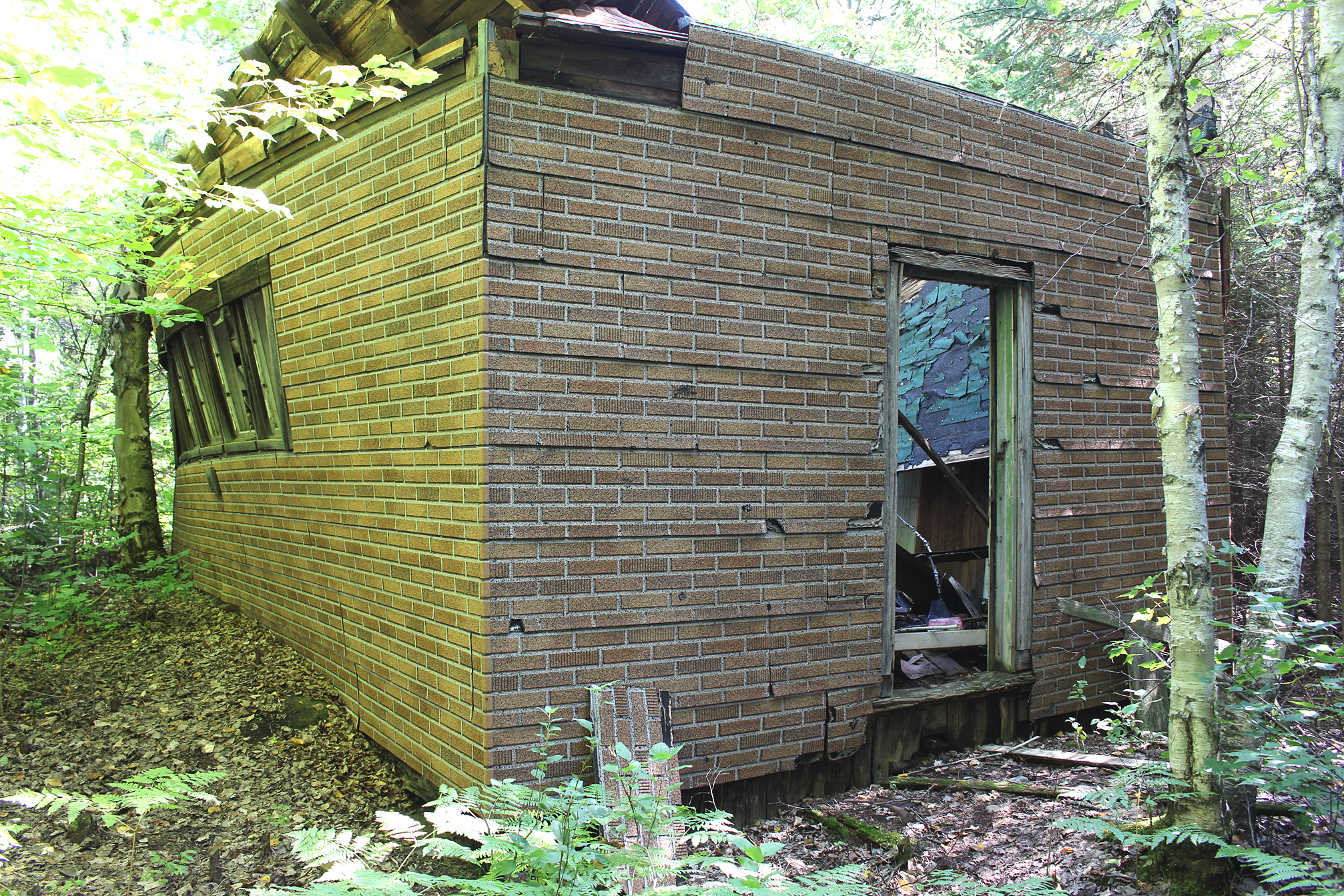
We wanted to find the old one room schoolhouse that was once used by the children of former park rangers, and probably those living in Daventry as well. We got out of the canoe and walked up to the old railbed to begin our search. It took the better part of half an hour wandering around the area until we found a diamond reflector on a tree with the faint words of “school” printed with a black marker. We walked back about 30 feet and there it was, although we were disappointed that the roof was caved in so we couldn’t get a good look inside.
The old one room school house at Daventry. (click image to enlarge)
Back in the canoe we continued our paddle and went underneath one more bridge before we arrived at our first portage of the day, a 140 metre into Laurel Lake where we met two other paddlers. We decided to give them a big head start on the portage as we sat down to have our first (and new) freeze dried meal of the trip, Backpackers Pantry Pad Thai which we gave a 8.5 out of 10 on the Aaron and Marianne tasty metre. Not only did it taste good but this meal actually serves 2 people. Though most freeze dried meals state that they serve two, there really is only one serving per pouch if you are really hungry. Perhaps it is based more on the sodium content than the actual weight of the food as these meals can pack A LOT of sodium.
While preparing the boiling water Marianne was delighted to see her favourite butterfly, a White Admiral, and tried for a few photos. We don’t get to see this species of butterfly back home in southwestern Ontario.
A worn but still beautiful White Admiral Butterfly. (click image to enlarge)
On Laurel Lake we paddled past our island site we stayed at back in 2010. This time we saw a couple leave the island, making their way to the same portage as us. We all arrived at the 280 metre portage and both parties had to figure out the best spot to take out as it was shallow and rocky.
Laurel Lake with the island site in the distance. (click image to enlarge)
After a paddle underneath one more bridge on Aura Lee Lake, and a very short paddle on Little Cedar Lake, we soon entered the wide expanse of our largest lake of the trip, Cedar Lake. We wanted to look for the remains of the Kish-Kaduk Lodge which is located on the north shore of a peninsula. Only accessible by train, the Kish-Kaduk Lodge was the longest operating lodge in northern Algonquin Park from the late 1920s and lasting close to 50 years. We landed at the campsite that was close to the known location where we found the wheels from an old boat ramp rail car. Wandering back into the bush we attempted to discover more relics. We couldn’t find the full extent of the ruins, and the cloud of mosquitoes that decided to show up didn’t help the situation. We did find what looked to be a root cellar along with other miscellaneous items.
A cold store and other items which may be remnants from the Kish-Kaduk Lodge. (click image to enlarge)
Back in the canoe we eventually paddled out of range of the mosquitoes as we continued down Cedar Lake. A few canoes and a few boats with outboard motors were also enjoying the sunshine and light breeze. Around 4:00pm we decided to look for a site and chose the second one north from some sites on the west shore. From our site with a pair of binoculars we could just make out the Brent campground on the opposite shore. It was a pretty big site, with a level spot for the tent, plus the always appreciated sandy beach. A few mosquitoes were at the back of the site but they were only a minor nuisance. We pumped water for supper and had a small fire to burn some garbage and create smoke to ward off the mosquitoes.
Our site on Cedar Lake. (click image to enlarge)
Winding up our little radio the Environment Canada forecast predicted rain for tomorrow. Just as long as it stays away until after we take down the tent.
Wildlife Sightings: Common Loon, Red Squirrel, Blue Jay, Common Raven, Golden-crowned Kinglet, Swainson’s Thrush, Herring Gull, Canada Goose, Mosquitoes, White Admiral, American Robin, People, Belted Kingfisher
Remember to: No remember to today! Whoot!
DAY # 4: Cedar Lake to Catfish Lake
Weather: Showers in the morning. Wind in the afternoon with lingering showers in the evening. High: 14C Low: 9C
topoView USGS. (click image to enlarge)
We set the alarm for 5:45 am this morning to get a head start before the forecasted rain arrived. As we were ready to take down the tent it began to rain, though only with a light drizzle.
Sunrise on Cedar Lake before the rains. (click image to enlarge)
Paddling down Cedar Lake towards the Petawawa River the rain continued. We could see Brent in the distance on the opposite side of the lake. Before the railway was built, Brent Station had a few lumber companies operating there, along with a depot farm back in the day. During the 1930s it was quite the bustling town with a school, hotel, restaurant, water tower, housing, a sawmill, and even generators to power the town. Today Brent has a few remaining cottages (the generators are gone) along with a few other remaining buildings. The area as a whole has been transformed into a campground similar to the one at Kiosk with 30 sites, 2 jump off sites, and 2 cabins for rent. The Brent Store, run by the Algonquin Outfitters, offers basic supplies and canoe rentals. Similar to Kiosk there is no cellphone service. What may be Brent’s claim to fame is the three kilometre wide hole from a meteorite that crashed into the earth over 400 million years ago. A trail goes down into the crater and you can also paddle/ portage into Gilmour and Tecumseh Lake that lay inside the crater.
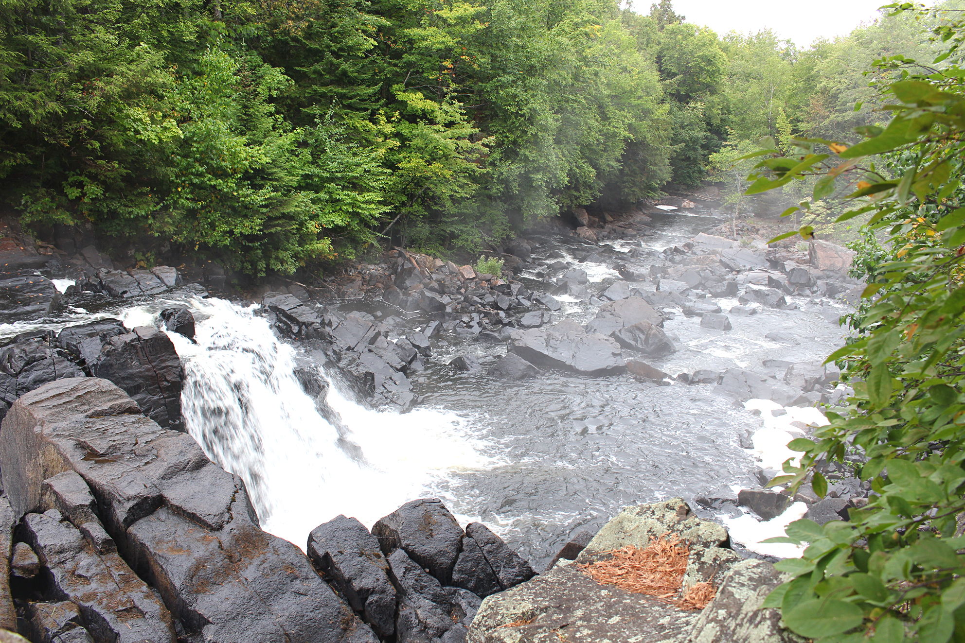
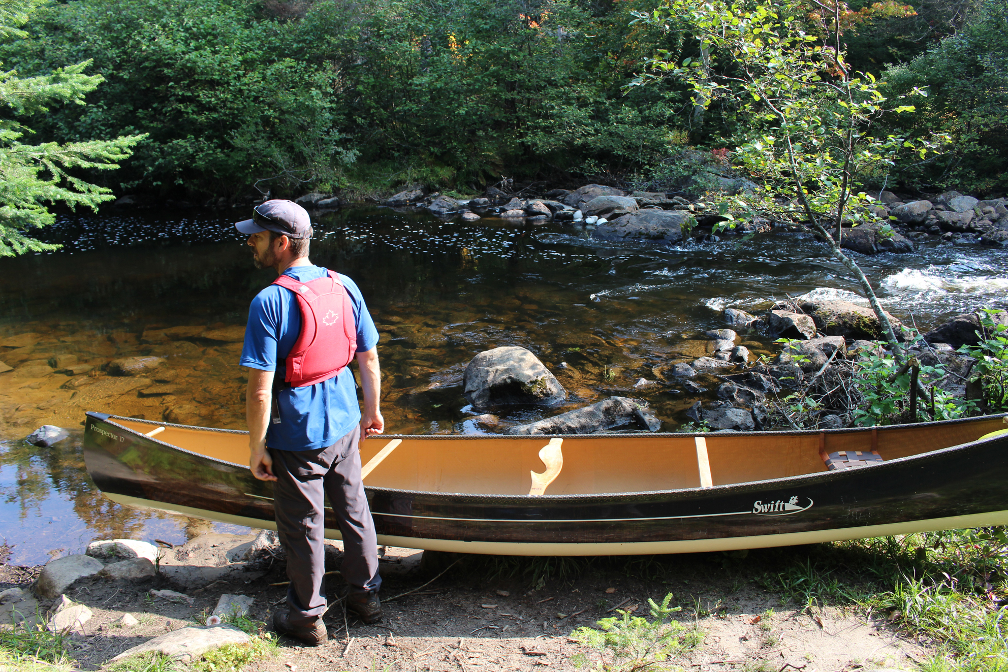
Our first portage of the day at 695 metres was not too difficult as was the 300 metre portage after that. Along both of these portages we had great views of some falls and rapids along the Petawawa River.
Falls along the Petawawa River. (click image to enlarge)
The next portage, at 2,345 metres around the Stacks Rapids was the longest for the day as well as for the entire trip. Nicknamed “Unicorn Hill”, not only was it long but there was a pretty big climb to it. Doubling over first with the packs, followed by the canoe, it took us two hours and twenty minutes to complete. Of course we took a few breaks along the way for water and GORP.
Beware of portages with nicknames. (click photo to enlarge)
It was along one of these portages (don’t exactly remember which one) where we saw that someone graffitied the rocks with their initials along with images of flowers and butterflies. This wasn’t done with chalk that would disappear in the rain, but with paint! We were pretty ticked at this blatant vandalism to park property. It looked like something a kid would have painted and we fear that some ignorant parent told their kid that this was okay. We forgot to take a photo though maybe it was for the best as we don’t want to recall it whenever we go through our photos.
It was towards the end of Unicorn Hill that the light rain stopped and we heard what sounded like a logging truck. The history of logging in Algonquin Park goes back to the 1830s, and amid controversy logging continues to this day. As we made it to the lake we finally saw the logging road. The next portage at 170 metres went over the logging road where we looked both ways before crossing.
Falls at the Petawawa River. (click image to enlarge)
At a mere 80 metres, our last portage gave us views of an old log chute. Not much is left of this old relic, a stark contrast to the logging truck we could still hear downshifting behind us in the far distance. Though logging in Algonquin Provincial Park is frowned on by many today there is no denying the rich and fascinating history of the logging era even before Algonquin Provincial Park was created in 1893. J.R. Booth, a legendary lumber tycoon/railroad baron conceived the first railroad, known as the Ottawa, Arnprior and and Parry Sound Railway, to run through the park. Though he devised the rail line to expand his growing lumber empire, the arrival of the train into the interior of Algonquin Park was also the first time visitors could really gain access to the park for outdoor recreation.
The remains of an old log chute. (click photo to enlarge)
Continuing on Narrowbag Lake we were greeting by three River Otters that chirped and grunted at us as we crossed paths. Now that the rain let up the wind took its turn and it began to pick up as we entered Catfish Lake. We paddled towards a small island to find another logging relic, an “Alligator”. Created in the late 1800s, these steam powered amphibious boats not only moved log booms across lakes but could also winch itself over land! Can you imagine seeing this mechanical beast slowly moving along a portage? What remained of this particular alligator, now abandoned on an island on Catfish Lake, was only its metal guts.
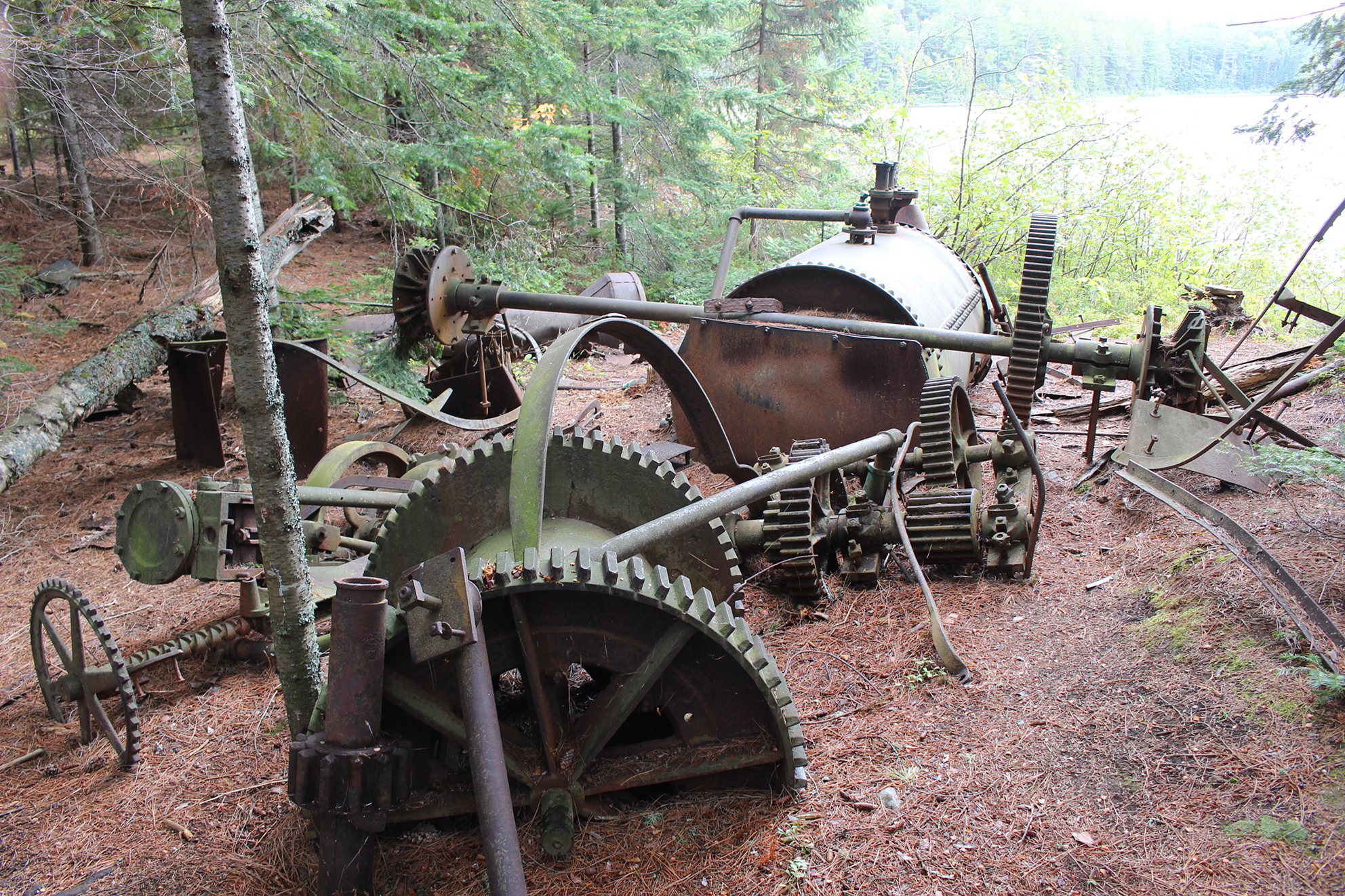
Abandoned alligator on Catfish Lake. (click image to enlarge)Wish we could make this out. (click image to enlarge)Another angle showing the remains of the alligator tug on Catfish Lake. (click image to enlarge)
Headwinds greeted us as we paddled into the centre of Catfish Lake and it was a slog to get much forward momentum. We aimed for Shangri-La Island, but instead we thought it would be better to take the site in a sheltered bay. There was an excellent firepit at this site, a flat spot for the tent, but a very mediocre spot to bath which we both attempted to do shortly after arriving. A few pesky mosquitoes hung around until a smoky fire deterred them as we prepared our supper. Tonight’s meal was Macaroni and Cheese with some rehydrated broccoli from our garden, along with some vacuumed packed tuna mixed in. This was our first night preparing supper over a fire which was a good thing as we were already down a fuel can out of the three we brought. Around 6pm the sun peaked out from behind the clouds which was a welcome sight. Unfortunately an hour and a half later it started to sprinkle rain again and we thought we heard a distant rumble of thunder. As a precaution we placed rocks on the tent pegs before going to bed.
The seating area at our site on Catfish Lake. (click image to enlarge)
Wildlife Sightings: River Otter, Common Loon, Yellow-rumped Warbler, Blue Jay, Black-capped Chickadee, Wood Duck, Double-crested Cormorant, Canada Goose, Mosquitoes, Great Blue Heron, Red Squirrel, Golden-crowned Kinglet, Herring Gull, Dark-eyed Junco, Belted Kingfisher, Spotted Sandpiper, Common Raven, People
Remember to: Spray the camera bag with some water proofer when we get home
DAY # 5: Catfish Lake to Burntroot Lake
Weather: Light showers in the morning. Clouds, breezy in the afternoon. High: 17C Low: 13C
topoView USGS. (click image to enlarge)
It was cloudy and mild while having breakfast this morning and a few mosquitoes hoped for a meal as well. A brief sprinkle of rain came through and we were both thankful that it only lasted a few minutes as we had all the contents of our packs just laying out on the ground.
We launched just after 8:00am and made our way towards the Petawawa River again. Today we had four portages along the river and thankfully they were all relatively flat. A few light showers that came through did not even phase us.
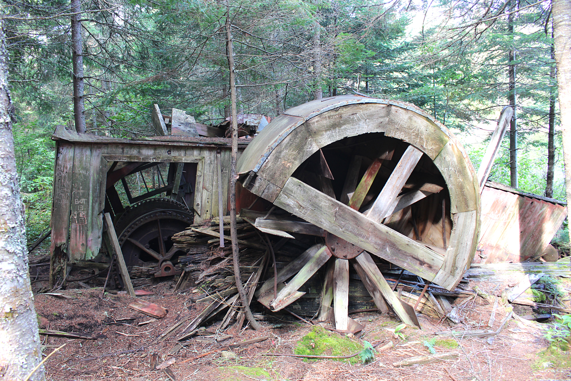
The water levels on Catfish Lake looked pretty low and we got stuck a few times while paddling the Petawawa River, but never to the point that we had to get out and drag the canoe. At the 155 metre portage into Burntroot Lake we checked out the cold cellar behind a campsite. This cold cellar appears to be pretty much intact and is impressively built! We wonder who built it? Perhaps there were supplies kept in there during the old logging era, the same era when that alligator on Catfish Lake would’ve been in it’s prime.
Cold cellar at the end of the portage to Burntroot Lake. (click image to enlarge)
Our plan was to stay on the island site on Burntroot Lake, so before getting back into the canoe we took some time to find firewood and load it in.
Entering Burntroot Lake we had a breeze that was at our backs. We aimed for Anchor Island but went for the eastern side of the island as we figured the western, more desirable side (the one with the anchor from an alligator) was probably taken, and we were also tired and hungry. Our site had an okay landing but no good spot to bath. The firepit and seating area was excellent, and there was a nice level spot for the tent. This site also looked to have a lot more use than our previous sites so far. There were a few things left behind by others including a clothesline.
Excellent seating area at our site on Burntroot Lake. (click image to enlarge)
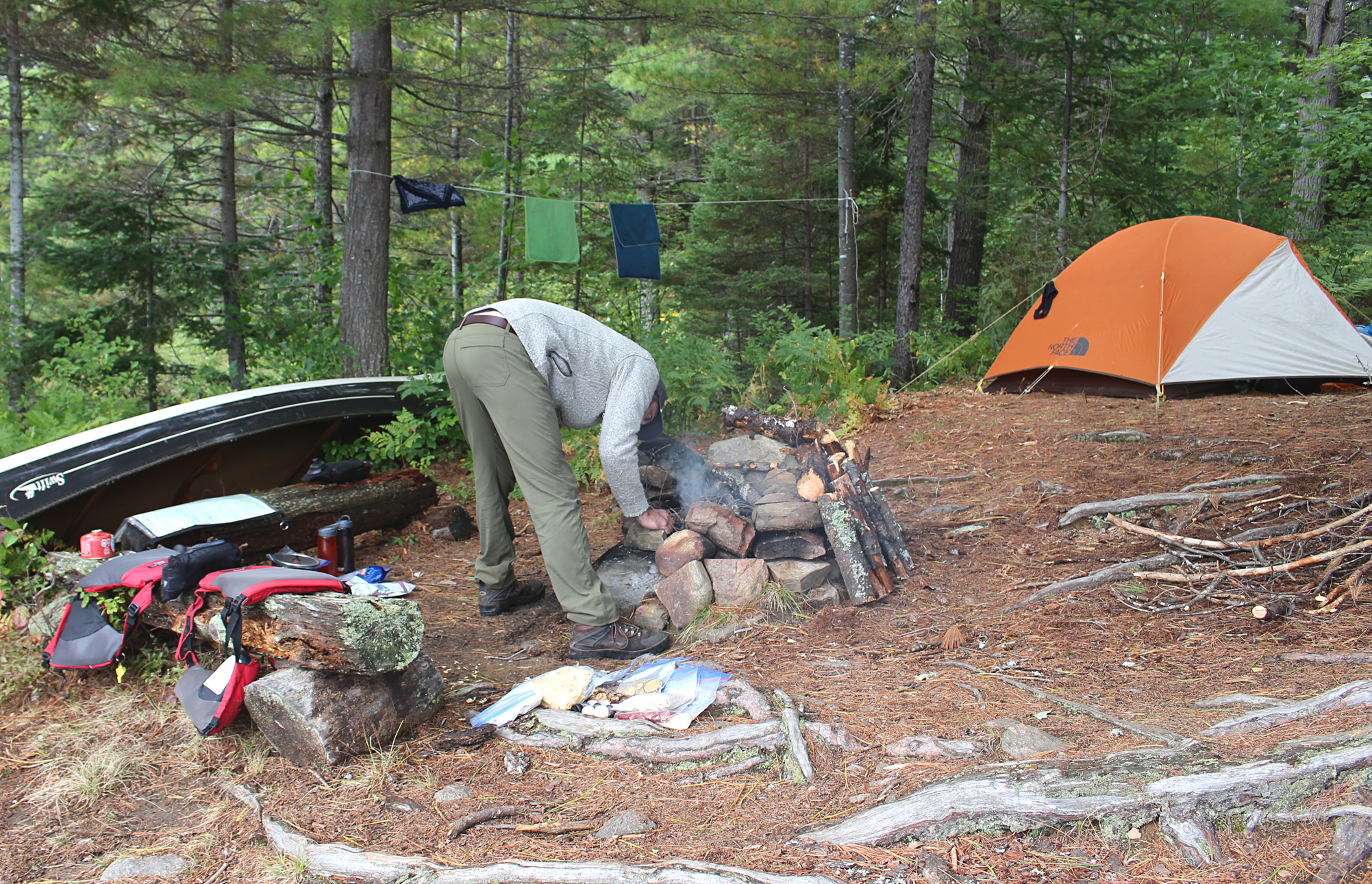
After getting the tent set up Aaron pumped water and fixed up the put in while Marianne tried for a bit of photography. It was supposed to get up to 20 degrees Celsius today, but our thermometer read 14 degrees Celsius and we felt slighting chilled unless we were moving around. The breeze now switched and was going through our site which made it too windy to make a fire. We killed time in the tent playing cards hoping that the wind would die down after sunset. After 7:30pm we ventured out and tried to make a fire though it was still a bit breezy. In an hour it died down considerably. We made homemade Sheppard’s Pie with stuffing over the firepit and eventually we got warm enough to be completely comfortable. We were in the tent by 9:45pm.
Wildlife Sightings: Ruffed Grouse, Canada Geese, Bald Eagle, Great Blue Heron, Wood Duck, Belted Kingfisher, Black-capped Chickadee, Herring Gull, Red Squirrel, Double-crested Cormorant, Broad-winged Hawk, Solitary Sandpiper, People, Northern Flicker, Winter Wren
Remember to: No remember to today! Yeah!
DAY # 6: Burntroot Lake to Big Trout Lake
Weather: A mix of sun and clouds. Breezy. High: 17C Low: 9C
topoView USGS. (click image to enlarge)
We had calm winds for the most part while we ate our oatmeal breakfast with a spot of tea over the fire this morning. Just the odd light gust of wind came through our site which was nothing to be concerned about.
Nothing is better to bring morale to the soul than a hot tea early in the morning. (click image to enlarge)
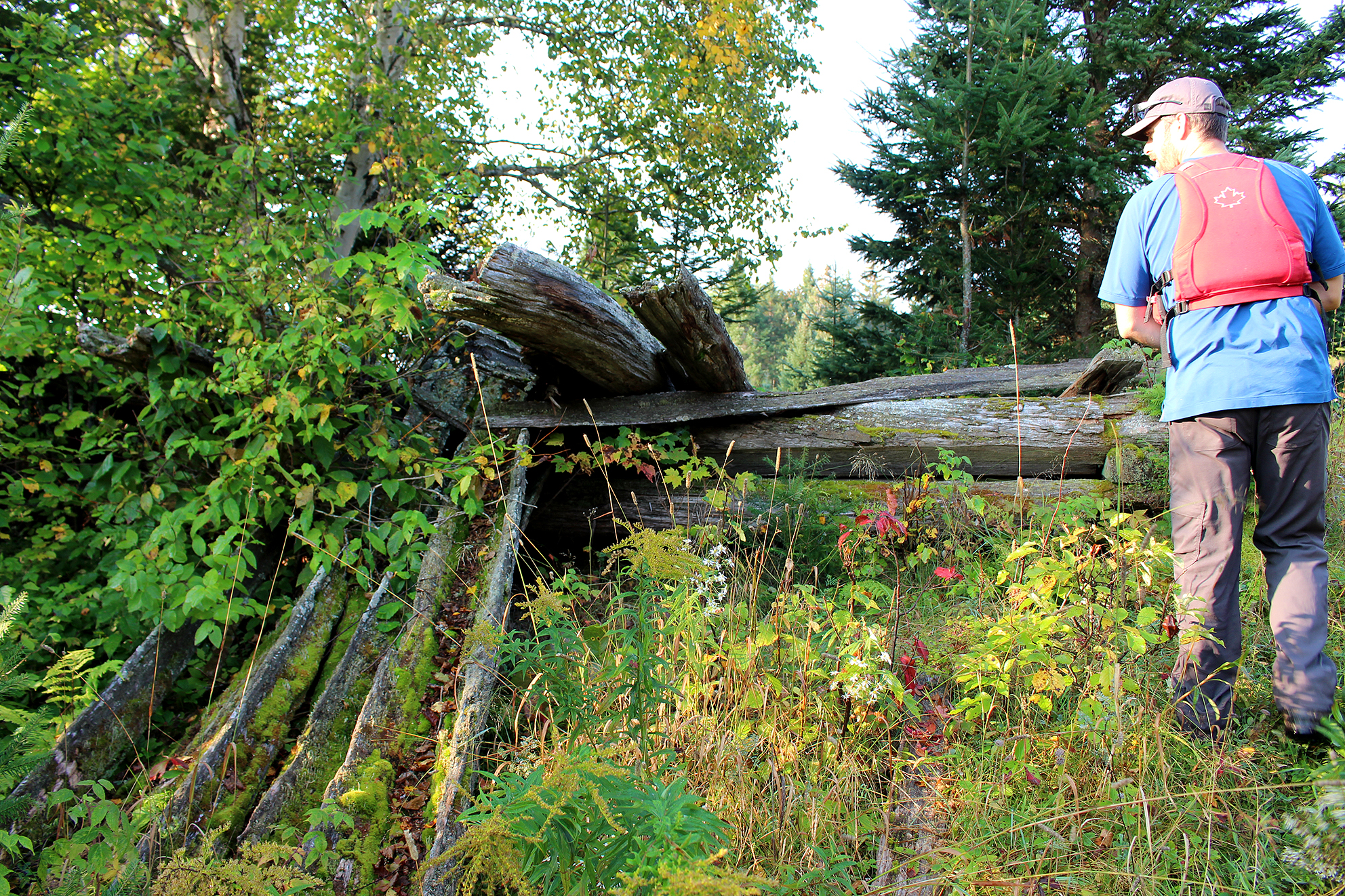
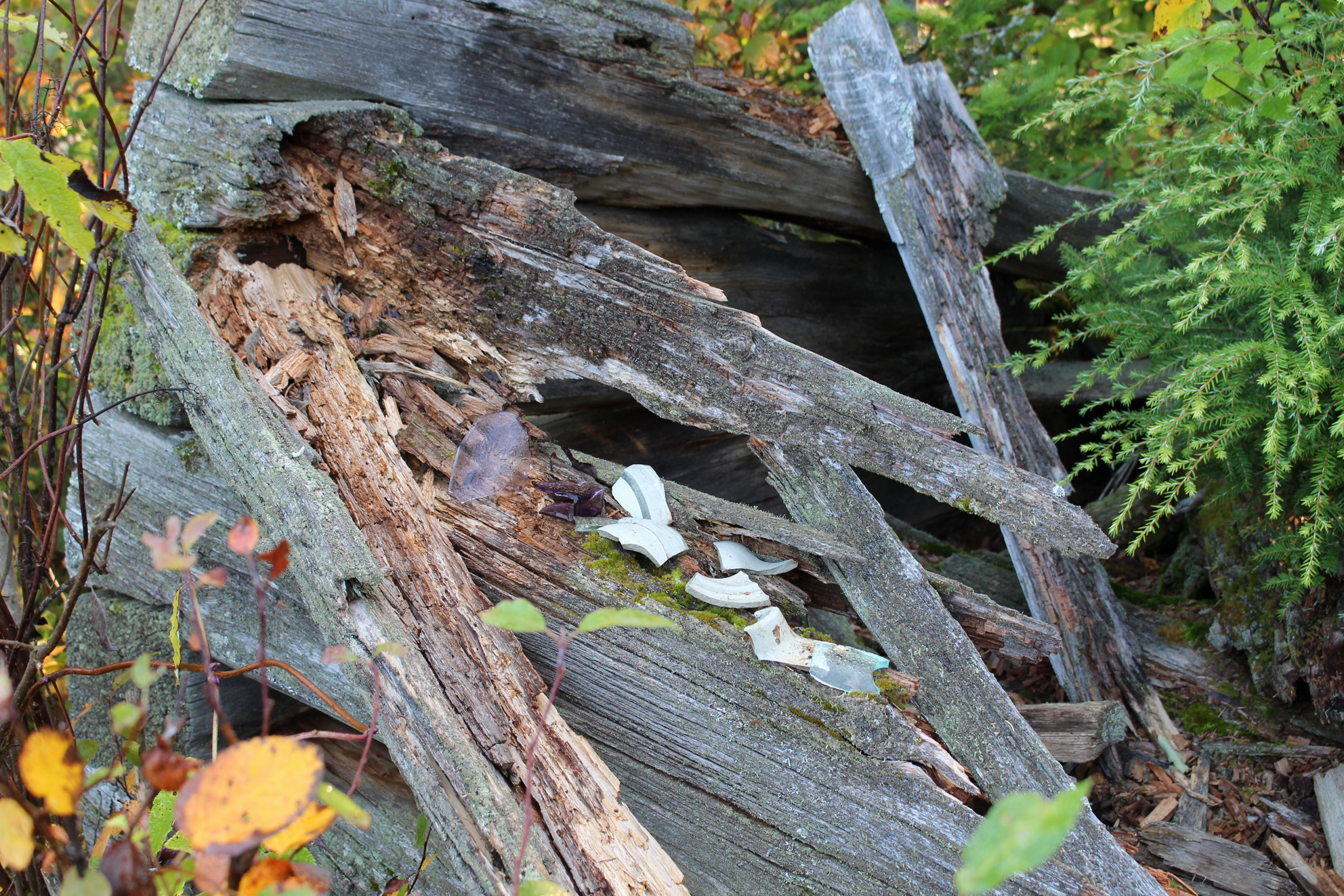
When we launched just after 9:00 am it was very calm so we decided to venture out on a side trip we planned if the weather was favourable. In the southwest corner of Burntroot Lake lies what little is left of the Barnet Depot Farm. Built in the late 1880s to supply logging camps it would have been quite the location to check out back in the day but we could not find any signs of it, though we did find what may have been a clearing. What we were really looking forward to finding was another alligator tug, one that still had part of its wooden structure. We paddled around a corner towards the end of the lake and there it was like a large beast in deep slumber amongst the trees next to the shoreline. As Marianne took some photos, Aaron waited patiently in the canoe while the breeze picked up. We skipped on looking for the other relics, which would have included another cold cellar, in fear that we may get some pretty nasty winds on the open lake. Before we knew it we were battling headwinds while paddling north, then northeast.
Approaching the sleeping beast on Burntroot Lake. (click photo to enlarge)The alligator tug on Burntroot Lake is a lot more intact than the one on Catfish Lake. (click image to enlarge)Another angle of the alligator tug on Burntroot Lake. (click to enlarge)
Once we paddled around the peninsula into the southeastern end of the lake we finally caught a well deserved breather. It was quite sunny this morning so it was time to apply some sunscreen. Unfortunately Marianne knocked her sunglasses into the lake while putting her hat back on, her second pair of sunglasses to be claimed by the waters of Algonquin Park.
Short portages were on the agenda today. First was a scenic 75 metre that led us walking just above and parallel to the moving water, while the 40 metre portage had not only a rocky take out, but also was lined with poison ivy.
Longer Lake had some shallow sections where Canada Geese gathered and honked as we paddled past. We got stuck a couple of times in shallow water, so we just backed up with our paddles and went around into slightly deeper water. Continuing south the water got deeper and Canada Geese were replaced with Double-crested Cormorants and we flushed some off of a rock that was white washed with guano.
Our last portage of the day was a well maintained 300 metre into Big Trout Lake. Along here we met a soloist who started from Cedar Lake who hoped to get a view of his first live Algonquin Moose down the Nipissing River. He told us that all the Moose he has ever observed in the park were dead Moose. We planned to spend tonight and all day tomorrow on an island on Big Trout Lake, so we gathered fire wood along the portage.
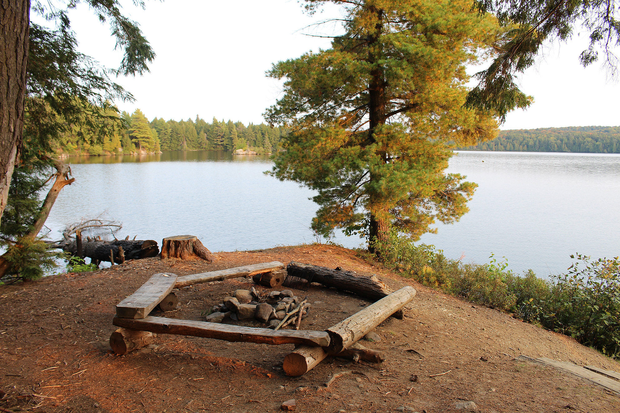
We arrived at our island site at 3:15pm and it was a great site! There were two sites on this island, but you are far enough away from your neighbour to not even realize their presence. We chose the site on the south side which was a large site with an okay firepit, okay put in, and an okay spot to bath. There was a nice flat spot for the tent in a shallow depression, while the view of Big Trout Lake was excellent! Taking advantage of the sun we bathed in the lake and later pumped water.
Our island site on Big Trout Lake all set up for supper with a an excellent view of the lake. (click image to enlarge)
The winds died down completely this evening and we cooked our homemade spaghetti over the fire. The moon rose and reflected off the water. We were looking forward to spending the next day just relaxing at our site.
Moon rising on Big Trout Lake. (click image to enlarge)
Wildlife Sightings: Canada Geese, Belted Kingfisher, Double-crested Cormorant, Common Loon, Mallard, Wood Duck, Blue Jay, Frogs, Fish, Common Raven, People, Herring Gull, White Admiral, Brown Creeper.
Remember to:Bring an extra pair of sunglasses in camera bag or try to find a sunglass floaty that actually fits the sunglass we buy.
DAY # 7: Big Trout Lake
Weather: Sunny and windy in the morning, with continuing wind, along with showers and thunderstorms in the afternoon into the evening. High: 18C Low: 10C
topoView USGS. (click image to enlarge)
Though we had a great spot on Big Trout Lake, it was completely exposed to the strong southeast winds we had for most of the day today.
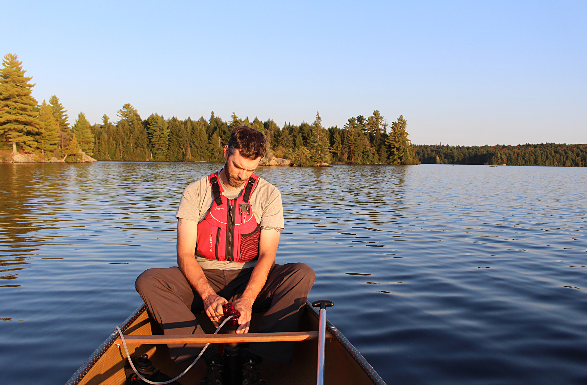
We started our morning with breakfast in the sheltered vestibule of the tent. Shortly after that we wandered our island site trying to find a spot to pump water. Everywhere we wandered the water at the shoreline was a little too rough to put the filter into the water. In the end we went back to the put-in and with our pot we lightly dipped it just below the water’s surface so not to collect a lot of organic matter. We stuck the filter in the pot and pumped from there.
Early morning at our site on Big Trout Lake with choppy waters. (click image to enlarge)
Being halfway through our trip it was time to reorganize our food. We took shelter beside the canoe that was used as a wind break next to the tent, and laid out our remaining meals/snacks to be divided up between us. Today would have been the day to just lounge around our site, but this wasn’t an option in these wind gusts, so we were forced to retreat to the tent to play cards and nap.
During the afternoon the clouds began to roll in. We knew rain and possible thunderstorms were in the forecast so we covered our packs and slid them underneath the canoe. For additional support to the tent Aaron propped up a stick in the vestibule which was beginning to bow in these wind gusts. He also placed some dried pine needles around the opening between the fly and the tent to keep out the draft. Around this time it began to rain so we retreated again to the tent and played cards. A few distant rumbles of thunder to the south of us made us wonder how many people were windbound that actually had a destination to go to today. After the rain stopped we ventured outside and saw a pool of water adjacent to the tent! We built a dam between us and the pond and carved a ditch to drain the pond towards the lake. Before too long another shower came through so we retreated yet again to the tent. This was where things began to get interesting…..in an unfortunate way. We felt that it was kind of squishy underneath us in the tent and when Aaron looked under his sleeping bag, the sleeping pad directly underneath it had a little bit of water on it. When he lifted the sleeping pad itself there was water on the floor of the tent! The water came in between the ground sheet and the tent causing it to flood! This was not good especially since our sleeping bags are down filled and should never get wet. We then sprung into action by grabbing our camping towels to mop up the water and rung it out in our pot. As dark approached we dug more trenches around the tent and drained away the water before the next round of showers came in at around 8:30pm. The wind picked up and a thunderstorm just barely stayed to the north of us.
Inbetween storms at our site on Big Trout Lake. (click image to enlarge)
This was the first time our tent has ever flooded. The culprit? We figured that the pine needles Aaron placed between the fly and the tent caused the rain water to collect on the pine needles and run underneath the tent. Normally water would just run off the fly and away from the tent. Either way we discovered that not only was the bottom of our tent no longer waterproof, but even after spraying the tent before we left there was a small leak in the top of our tent. After a good 10 year run we think it is time to retire our Northface Rock 22. Too bad Northface hasn’t released this tent in a few years now.
Wildlife Sightings: Really nothing….we stayed in the tent for most of the day. We didn’t see a single soul as well as most, if not all, would’ve been wind bound.
Remember to: Any windbreak needs to be inside the fly, not outside of it
DAY # 8: Big Trout Lake to Whiskey Jack Lake
Weather: Breezy with light rain showers in the morning. Cloudy by evening. High: 15C Low: 13C
topoView USGS. (click image to enlarge)
With forecasted 20 – 40 kph wind gusts we had only bars and water for breakfast and before sunrise at 6:30 am we on the water while wearing our headlamps. Heading back the way we came made paddling during the cloudy predawn skies easier as we knew exactly where we were going. On the well maintained 300 metre portage we used our headlamps to help light our way so not to trip over the few slippery rocks.
We had an easier go on Longer Lake this time as we never got stuck in any of the shallow spots. The segregation of waterfowl remained the same since we were here a couple of days ago with the Canada Geese occupying the shallow areas, while the Double-crested Cormorants claimed the deeper sections.
Arriving back on Burntroot Lake we had an easy paddle until arriving in the open section of the middle of the lake where we were exposed to the southwest winds. The winds were hitting the left side of the canoe which is about as much fun as headwinds for steering, if not worse. Dodging behind an island we got out of the wind and eventually we turned in a more northerly direction with the winds at our backs. For the most part the winds were just a minor annoyance, not as treacherous as we were worried they would be. When we arrived at the sandy/sheltered take out at the 1,310 metre portage to Robinson Lake we were hungry and celebrated our windy crossing with some GORP and a well deserved swig of water.
Even our canoe needs a well deserved break from the winds of Burntroot Lake. (click image to enlarge)
The portage into Robinson Lake was interesting as far as portages go. It was flat for the most mart but also wider than most portages we have ever been on…ever! Quite a few downed and thankfully cleaned up trees lined the portage as well. Clearly a weed whacker was also used to clear away the sides of the portage which we found a little odd. As we arrived to the end of the portage it began to mist rain though luckily it was short lived.
Robinson Lake, named after a park ranger from the early 1900s, was a new lake for us. It was a nice small lake with two unoccupied island campsites, while the water level appeared higher than some of our previous lakes. One last 25 metre portage and we were in another new lake known as Whiskey Jack Lake. We have yet to see a Whiskey Jack, now known as the Canada Jay. Our usual experience with this species in Algonquin is feeding one out of our hands on a trail during the winter.
Gloomy skies on Whiskey Jack Lake. (click image to enlarge)
On Whiskey Jack Lake we paddle into the strong southwest headwinds and made our way slowly towards the peninsula site. Unfortunately it was extremely exposed, with event the thunderbox exposed for all to see, so we quickly changed our minds. The site along the south shore was occupied so we made our way to the north shore and a site that was partially protected from the wind thanks to an island directly in front of it.
This site was okay. The spot for the tent was kinda sloped, there was an okay spot to bath, and an okay firepit. We had a late lunch of pasta with rehydrated vegetables and managed to make a fire. Misty rain continued off and on but it was always short lived. Marianne got out her rope, made a clothesline, and rinsed out our towels we used to mop up our tent last night.
Preparing for supper at our site on Whiskey Jack Lake. (click image to enlarge)
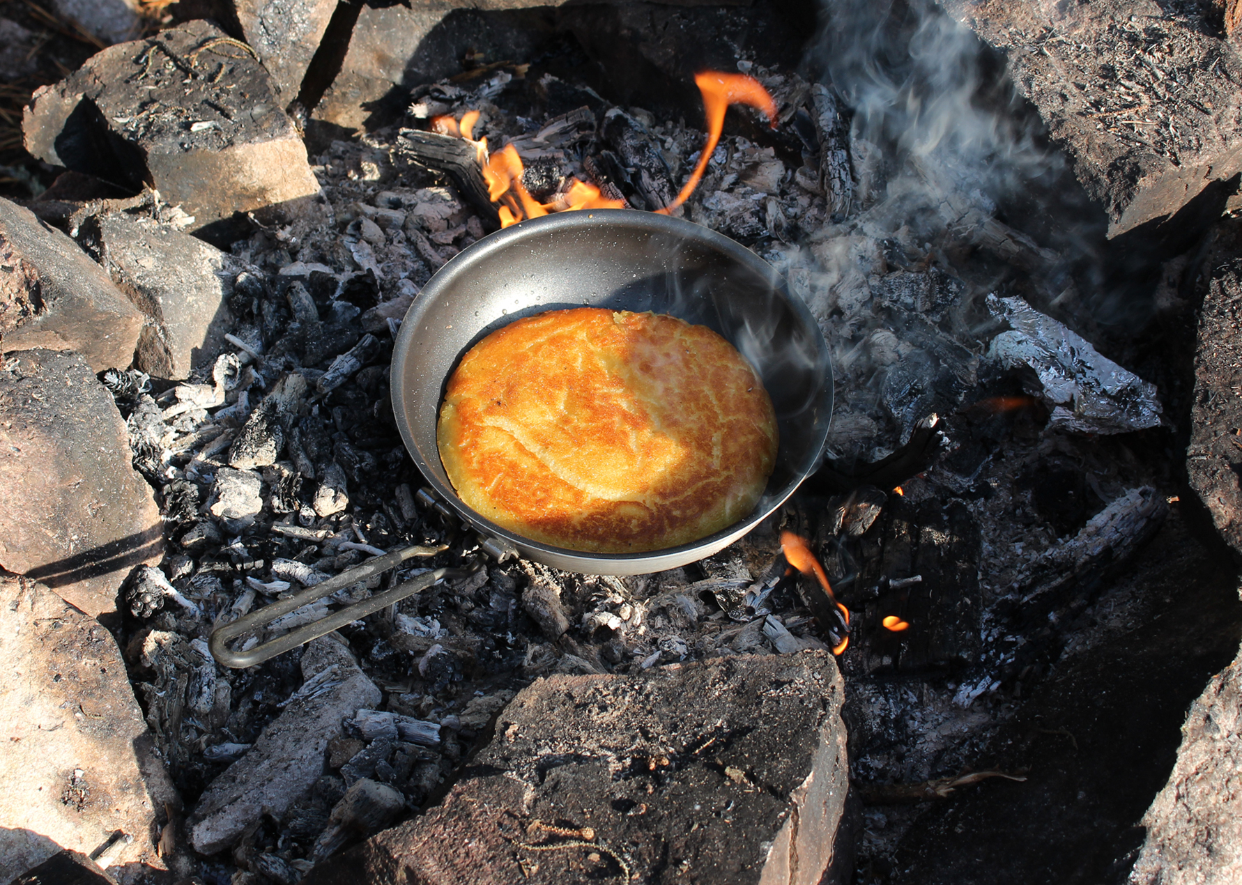
By evening the wind died down and we had another glorious fire complete with coals to make bannock, which tasted great with a side of hot tea. The moon made another appearance tonight but it was quickly shrouded by clouds.
Wildlife Sightings: Common Loon, Double-crested Cormorant, Black-throated Blue Warbler, Moose tracks and scat, Canada Goose, Wood Duck, Golden-crowned Kinglet, White-throated Sparrows, Dark-eyed Junco, Red-breasted Nuthatch, Black-capped Chickadee, fish, people.
Remember to: No remember to today! YAY!
DAY # 9: Whiskey Jack Lake to Nadine Lake
Weather: Mainly sunny skies. High: 18C Low: 7C
topoView USGS. (click image to enlarge)
We had cool temperatures this morning when we launched at 7:50am. Portaging and river travel were on the agenda for today. We had a surprise waiting for us at our first portage, a pile of bear scat that still radiated heat! Knowing that the bruin was probably still around we made ourselves known by chit chatting the whole length of the portage. After a short paddle across Remona Lake, we arrived at our longest portage of the day, a 1,930 metre that was relatively flat. There was also an old road that crossed through it. Perhaps this was once a logging road.
Predawn on Whiskey Jack Lake. (Click image to enlarge)
We soon began to make our way down the Nipissing River. The Nipissing is a tributary of the Petawawa River, nearly 100 kilometres long, and is entirely within the northern half of Algonquin. The river consists of waterfalls, dams, and calm meandering sections where moose and waterfowl are not uncommon. The human history of the Nipissing River includes logging and even a World War II POW camp for German captives. Yes even in Ontario we had POW camps during the Second World War.
This was our second trip ever on the Nipissing River and it would be a short one. It wasn’t long before we had our first portage around some rapids. This portage was 850 metres and towards the north end of the portage we could clearly see what looked like a fence made from rocks running parallel to the portage on our left side, while the Nipissing was parallel on our right. Could this have been used during the logging days to help divert water? Perhaps there once was other structures along this stretch of river as well to help run logs? Unfortunately we could find no information pertaining to this section of the Nipissing River when we arrived back home.
Portage around the Nipissing River. (click image to enlarge)
Entering a calm section of the Nipissing River we were greeted with the call of a moose in the distance. We continued quietly in hopes of seeing one as we paddled through some twists and turns but no luck this time. We spotted a lot of birds along the river including a pair of Common Mergansers, a Belted Kingfisher, a flock of White-winged Crossbills that came to the river for a drink, and a Common Yellowthroat.
One more portage for the day which was unfortunately blocked by a tied up canoe right at the take out. We discussed what we should do as this portage was 1,410 metres long so who knows when this individual may finally show up. Luckily he was just at the campsite next to the portage and he overheard our conversation. Apologizing he moved his canoe out of the way stating that we were the first people he has seen. We had to lift our canoe out of the river and up a steep bank to reach the portage. We also had a quick visit with the soloist who was out for 4 days.
As we bid him farewell we began our constant uphill climb that would take us to Nadine Lake. When we got to the end of our climb we had to turn around and go back for the canoe, the camera bag, and the snack bag. By the end of it all we were pretty sweaty.
Fall colours starting on Nadine Lake. (click image to enlarge)
One last short paddle and we arrived at the most northern site on Nadine Lake by the afternoon. The site had a great seating area, a nice flat spot for the tent, great spot to bath and dry clothes, and a good take out/put in. The view was also neat! We saw trees all around us but no sign of any elevation change. We felt like we were at Algonquin’s highest peak!
Our site at Nadine Lake. (click image to enlarge)
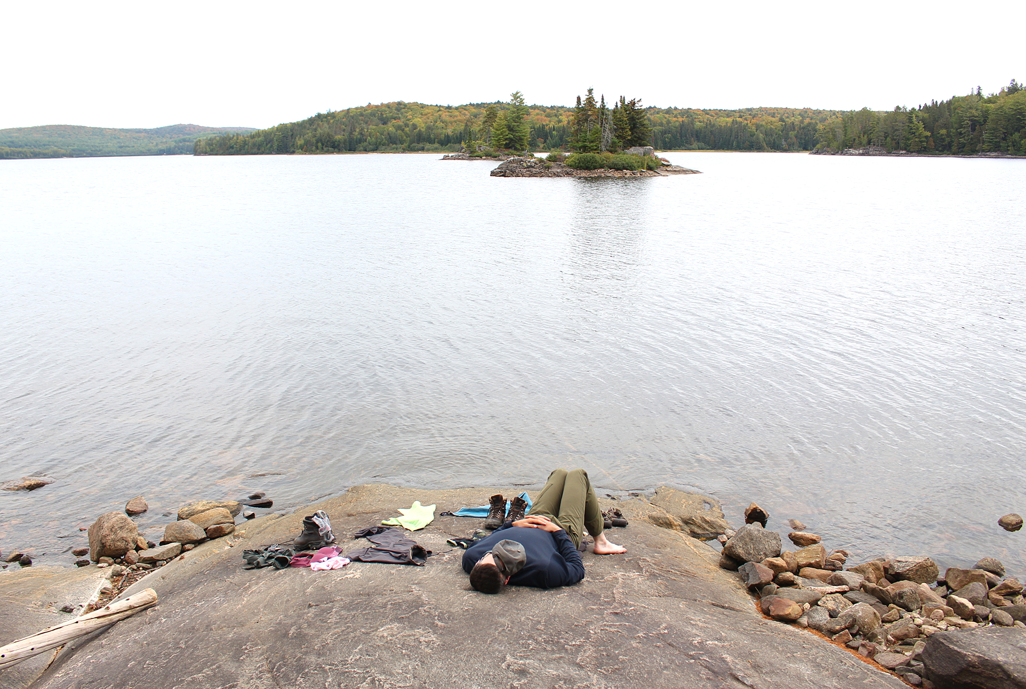
With the now sunny skies we took a bath in the lake and rinsed off some stinky clothes. Though cold, the water left us so refreshed and we dried off in the sun. Aaron had a nap while Marianne took a few photos of the site.
Laundry day at Nadine Lake. (click image to enlarge)
As we entered the second half of our trip the weather was improving with sunny skies and less wind. We had a fire this evening but we were actually not that hungry so we just ate some Kind Bars with a tea while we enjoyed each others company. We discussed, out of all things, our goals when we arrive back home. After we went to the tent a Barred Owl called “Who cooks for you!” in the far distance.
Wildlife Sightings:Black-capped Chickadee, Red-breasted Nuthatch, White-breasted Nuthatch, Yellow-rumped Warbler, Common Yellowthroat, Moose (heard only), Common Merganser, Common Loon, Red Squirrel, Golden-crowned Kinglet, Winter Wren, Song Sparrow, White-throated Sparrow, White-winged Crossbill, Cedar Waxwing, Black-throated Blue Warbler, Blue Jay, Common Raven, Toad, Fish, Yellow-bellied Sapsucker, Mosquitoes, Belted Kingfisher, Brown Creeper, Barred Owl, White Admiral, People
Remember to: No remember to today! YAY!
DAY # 10: Nadine Lake to Skuce Lake
Weather: A mix of sun and clouds. High: 18C Low: 5C
topoView USGS. (click image to enlarge)
A bit chilly this morning when we rolled out of the tent. Today was all about portaging! We had 3,935 metres worth of portaging to do and since we always make two trips it was actually 11,805 metres….yay!? We have hiked these portages before back in October of 2010, and we completely forget how brutal and steep they can be.
Early morning fog on Nadine Lake. (click image to enlarge)
The first portage of the day, was a 1,830 metre out of Nadine. This lengthy portage had some steep sections, so I guess we were not on top of the park after all back at our site. After dropping off our packs and going back for the canoe we spotted a black pipe towards the middle of the portage. We knew going in that this was a natural spring, unfortunately our water bladder was back with our packs so we didn’t get the chance to try the water.
The sun came out as we entered Osler Lake and it was a very calm paddle with not a breath of wind. The 700 metre portage between Osler and Little Osler Lake had remnants of an old road cutting through it. After a short paddle through Little Osler Lake it was time to tackle the 955 metre “Heart Attack Hill”. The name is appropriate as it was steep at both ends, though we think we had it a little bit easier with our packs coming from the south end instead of what it would be like coming from the north. The whole portage was done at a snail’s pace…..Honestly a snail probably could’ve passed us…
The next lake, Little Nadine, was the smallest one for the trip with no campsites and a muddy put-in. The take out wasn’t any better but at least there was the remains of a boardwalk to avoid the mud.
We had high hopes that our last portage, a 450 metre into Skuce, wouldn’t be as steep as Heart Attack Hill. For the most part it wasn’t as bad except right at the beginning where it was the steepest climb we had all day!
Skuce Lake was quite shallow with a marshy section found near the shore. We chose the middle site which was located in the deeper section of the lake, though there was a little bit of a marshy section towards the back of the site. It was probably the most mediocre site of our whole trip as the seating area was pretty much in ruins, and the thunderbox was in plain view. We could care less however as we were tired from portaging nearly 12 kilometers in around six hours total. What the site lacked in comfort it made up with a lovely view! After fixing the seating area so we could actually sit down comfortably Aaron had a nap. There were a few Red Squirrels that were not impressed with our presence so they gave us the death stare while chattering away at us for nearly half an hour.
Skuce Lake from our site. (click image to enlarge)
This evening we had a fire to burn some garbage and cook supper. After sunset we pumped water and watched the stars begin to twinkle. Shinning the light of our headlamps into the shallow water we managed to attract a few small fish.
When we retired to the tent we heard both Saw-whet Owl and Barred Owl announce their start to the night shift.
Wildlife Sightings: Red-breasted Nuthatch, White-breasted Nuthatch, Common Loon, Broad-winged Hawk, Eastern Chipmunk, Belted Kingfisher, Yellow-rumped Warbler, Black-throated Blue Warbler, Black-throated Green Warbler, turtle sp., Red Crossbill, White-winged Crossbill, Blue Jay, Moose tracks and scat, Red Squirrel, Mourning Cloak, White-throated Sparrow, Winter Wren, Song Sparrow, Canada Geese, Saw-whet Owl, Barred Owl, No people
Remember to: Never do “Heart Attack Hill” again!! …..we probably will..
DAY # 11: Skuce Lake to Maple Lake
Weather: Sunny skies. High: 21 C Low: 4C
topoView USGS. (click image ot enlarge)
Cool and calm when we left our Skuce Lake site at 7:30 am. We had a mix of portaging, plus lake and creek paddling today. We were very thankful that our portages were a lot easier than the ones we had the day before. Actually anything seems like a cake walk now after “Heart Attack Hill.”
Early morning Skuce Lake. (click image to enlarge)
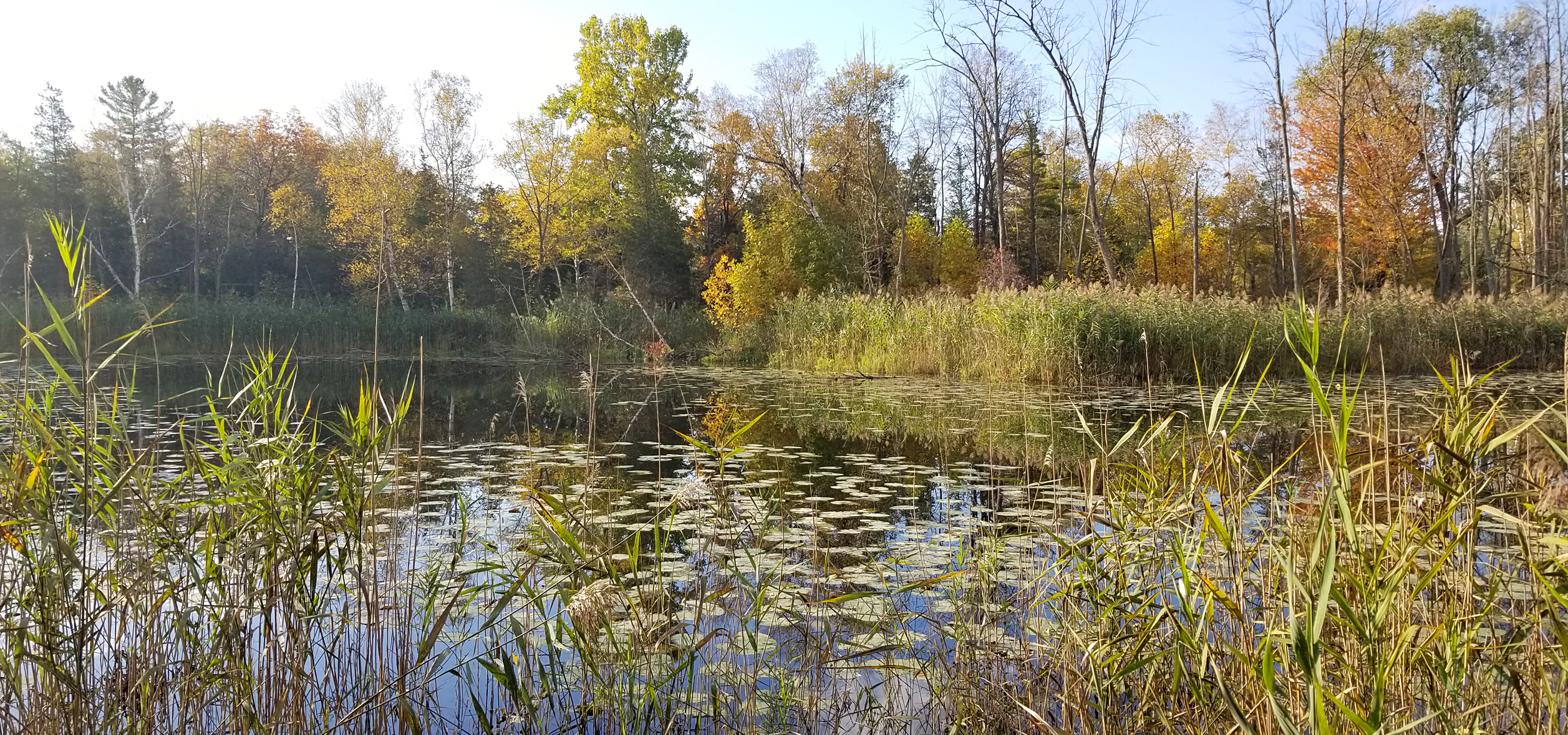
After the 695 metre out of Skuce Lake we entered Maple Creek. Prior to our trip, Maple Creek was noted to have low water levels, though we were assured from the park staff at Kiosk that we shouldn’t have any problems. As we entered the creek the first thing we had to contend with was our first lift over in the form of a beaver dam. The water level was also just high enough for our canoe. Throw in some rocks that are always where you want to paddle and you have the perfect trifecta of creek paddling in Algonquin Park! (liftovers, low water, and rocks).
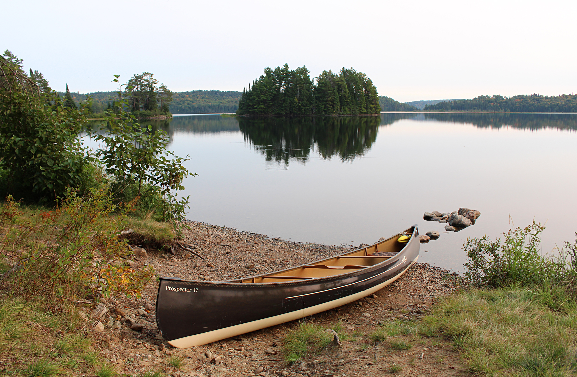
Ready to enter Maple Creek. (click image to enlarge)
Entering Erables Lake from the south was also pretty shallow while Erables Lake itself appeared shallower than most of our other lakes. It was so calm this morning that even a loon cruising beside us created wake, while a moose called in the far distance. At this point we felt like we were the only two people in the whole park as we haven’t seen anybody all day so far, or yesterday for that matter.
Our last portage of the day was a 170 metre into Maple Lake where we went over what looked like a regularly used logging road as we hiked beside Maple Creek. The put in to Maple Lake was quite muddy and we had to take it real slow paddling around painted rocks left by other canoes.
Maple Lake is one of our favourite Lakes in Algonquin! It was the first lake we ever backcountry camped in the park nine years ago so we aimed for the same site we had back then. We were in luck as we not only claimed the most northern island site on the lake, but we still haven’t managed to run into any other paddlers today!
Maple Lake from our site. (click photo to enlarge)
This small site had a good seating area and fire pit. There was a flat spot for the tent and an excellent spot to bath in which we took full advantage of in the warm sun. We also wrung out our clothes in the lake and placed them on the warm rocks to dry.
We only had three and a half hours of paddling today to get to this site so we had a big lunch of spaghetti and the rest of our parmesan Reggiano. After lunch we relaxed in the shade as the sun was hot! We also didn’t want to put on any sunscreen after finally having a descent enough bath. Three adult Bald Eagles circled over our island, perhaps debating when it was time to migrate south.
Our Maple Lake site. (click image to enlarge)
We definitely wanted a fire tonight but being on such a small island firewood was pretty scarce, so we hopped into the canoe and made our way to shore. We returned with quite a haul and unloaded it next to the firepit.
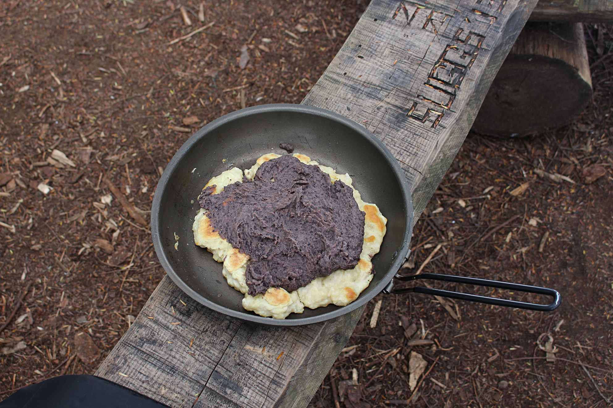
Tonight we had bannock with some special hummus that Aaron created with our black turtle beans from the garden back home. Not only did the hummus rehydrate well, it was also the best bannock we have ever had in the backcountry!
This evening we pumped water away from our site on some smooth rocks. As the sun set and the stars came out we made a fire and just relaxed. Right before bed we walked to the waters edge and looked up into the sky. It was a clear night and the sky was jam packed with stars with the milky way being extremely clear! We even saw a satellite go by.
Tomorrow we are to make our way up Maple Creek again and then back to Kioshkokwi Lake. Where did the time go?!
Wildlife Sightings: Common Loon, tiny fish around our site, Double-crested Cormorant, White-throated Sparrow, Winter Wren, Red-breasted Nuthatch, Moose (heard), Great Blue Heron, Blue Jay, Herring Gull, Common Raven, Comma species (probably Eastern Comma), Mourning Cloak, Pine Warbler, Yellow-rumped Warbler, Bald Eagle, Barred Owl, no people
Remember to: No doubt about it, we need to purchase a new tent. Besides being no longer waterproof, the zipper is starting to get faulty with the teeth coming apart after zipping it up. The poles have lost almost all their elasticity as well.
DAY # 12: Maple Lake to Kioshkokwi Lake
Weather: Partly sunny with a light shower in the evening. High: 23C Low: 13C
topoView USGS. (click image to enlarge)
This morning we both woke up stiff and looked forward to moving around outside the tent. After oatmeal and some tea in our bellies we were on the water by 7:45 am, heading back towards Maple Creek with its’ low water levels.
We had six portages in total along the creek today and why we thought they would be flat was anyone’s guess! Most had some hilly sections but none were even close to the grueling ordeal we went through just a few days ago. The put ins and take outs were as varied as they could be with a mix of flat, sinking mud, and/or annoying rocks that you had to balance on while getting not only yourself out of the canoe, but also your gear without setting it in the muck. Fortunately our packs were way lighter now after almost 10 days worth of food gone, plus 10 days to build some muscles!
The sun tried to peak out from behind the clouds this morning but we were actually glad that it stayed cloudy as this was turning into a warm and humid day. Winding our way down Maple Creek we paddled quietly as we entered the marshy section in hopes that we would catch a glimpse of a Moose. This would probably be our last chance to see one on this trip. Unfortunately we would be mooseless.
When we made it to the end of our last portage into Kioshkokwi Lake there was a huge expanse of mudflat from the low water levels. We followed a manmade trail in the grass as far up along the right side of the lake as we could go. Sticks and logs were placed into the muck from the shoreline to balance on so we could get into the canoe without sinking it into the mud.
Trying to get into Kioshkokwi Lake without sinking. (click photo to enlarge)
Sitting in the canoe we used our our paddles to push ourselves just above the mucky bottom. At the end of the mudflat we saw some migrating Greater Yellowlegs. Unlike us they were enjoying the mudflat as they fueled up on aquatic invertebrates for their continuing migration.
Entering Kioshkokwi Lake it was immediately evident that the fall colours have progressed since we were here over a week ago. Back then they were barely changing and now they were near 40% leaf change with maples dominating. No doubt in the next few weeks the highway 60 corridor will be a zoo of people immersing themselves in their beautiful colours!
We picked a site on a peninsula just out of view of the Kiosk launch. There was an okay firepit and seating area, along with a great spot to launch. We were hot and sweaty but there were no good spots to bath as the shallows were dominated by freshwater muscles (probably Eastern Elliptio), and we figured they didn’t want to share the space. We managed to find a small spot to take a quick bath just beside the mussels.
Chilling at our site on Kioshkokwi Lake. (click image to enlarge)
On all our backcountry trips we take into serious account what Environment Canada forecasts on our radio, though we swear every year they forecast the opposite of what actually transpires. This time around they called for partly cloudy skies, and instead we got completely cloudy skies, intermittent sprinkles of rain, and we heard the rumble of distant thunder as we pumped water. Luckily it stayed to the north and we only got a brief sprinkle as evening approached. Being close to the launch we saw a few people out enjoying the lake including those on their own backcountry trips.
Fall colours beginning to show along the north shore of Kioshkokwi. (click image to enlarge)
Visible with a pair of binoculars was a bare rock that appeared to be the favourite roosting spot of Double-crested Cormorants. In the calm evening as they came and left from their roost we could hear grunts and other non melodious calls that make up their repertoire. Looking back at our trip in 2010 we didn’t encounter any cormorants in this area. Either they have recently established in the last 10 years, or they already migrated when we were here last.
Tonight was our last night in Algonquin. We had enough food to last us 2 more days but we were in charge of closing up the cottage before driving home….and then back to our lives in southwestern Ontario….where it is flat and boring….
We took in as much as we could on our last night.
Sunset with clouds and some rain. (click image to enlarge)
Wildlife Sightings:Common Loon, Double-crested Cormorant, Belted Kingfisher, Blue Jay, Red-breasted Nuthatch, American Crow, Red Squirrel, Mourning Cloak, White Admiral, Great Blue Heron , American Toad, Canada Geese, White-throated Sparrow, American Black Duck, Golden-crowned Kinglet, Greater Yellowlegs, People, Moose tracks
Remember to: Buy Aaron some new camping boots, new water filter for pump, 2 new headlamps
It’s always a mixed bag of emotions on our last day. You want to stay out for another day or even a whole week, but when you are 3 kilometres away from the launch, a hot shower, and a cold glass of milk, you crave to get back to civilization and your own personal routine.
What would it be like if we were out for another week? It has been said that after 3 weeks of being in the backcountry you can loose those cravings completely as you begin what seems like a new normal. We have never been out for more than 2 weeks, with this trip being our longest ever! We do know that if we could we would love to stay longer, at least until our food runs out. However as stated earlier….we are this close….so close to our car…a hot shower….cold glass of milk…time to pack up.
We were probably the only people out on the lake when we launched at 7:10 am. The cormorants flew near us as they departed from their rock in search of their own breakfast (ours was honey granola with cranberries). The call from a lone Common Loon echoed across the lake, while a Bald Eagle stretched its wings during its morning flight. It was a very calm paddle.
As we approached the Kiosk campground we saw the pale plume of smoke rising from someone’s breakfast campfire. With no one at our Jump off site from our first day we decided to park the canoe there as we brought our gear back to the car. There were fewer people camping at the Kiosk campground than the last time when we first arrived, though that was a Saturday and this was Thursday. As we loaded the canoe on the car a camper told us of River Otters playing on the lake.
It was after 9:00 am when we hit the road to drive to Samuel De Champlain Provincial Park to use their showers, and later Huntsville for lunch. We relaxed this evening at the cottage on Lake Muskoka.
We hope this blog inspires others to venture outdoors. Algonquin Park is a wonderful location for those just getting into backcountry camping! Let yourself become detached from social media, detached from those little stresses in life that feel bigger than they actually are. People have lived long lives and prospered with only the little things before our generation…You can do the same if you just let go of life’s so-called “necessities” that society tells us to have. Go out and have a detox in nature.
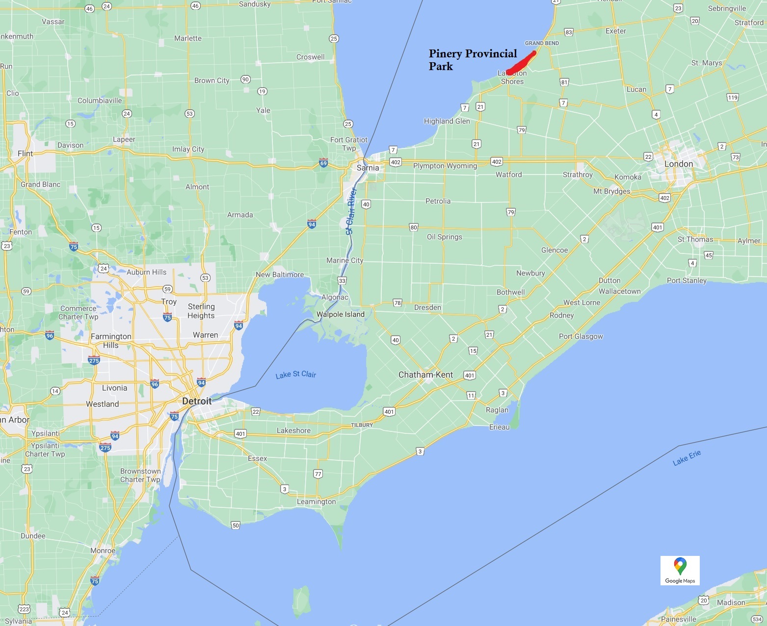
Carolinian splendor in Pinery Provincial Park. (click image to enlarge)
In our opinion, Pinery Provincial Park may be the only park in extreme southwestern Ontario that’s worth over night camping. Wheatley and Rondeau Provincial Park are great for a walk, and both are excellent for birding, but the Pinery just seems to offer better sites to camp. Maybe we are just camping snobs?
Pinery Provincial Park is around a 2 hour drive for us, and the only other time we have ever camped there was back in 2013 for a single night. We took full advantage this time around with sunny skies forecasted and went for 2 nights.
Location of Pinery Provincial Park in southwestern Ontario. (click image to enlarge)
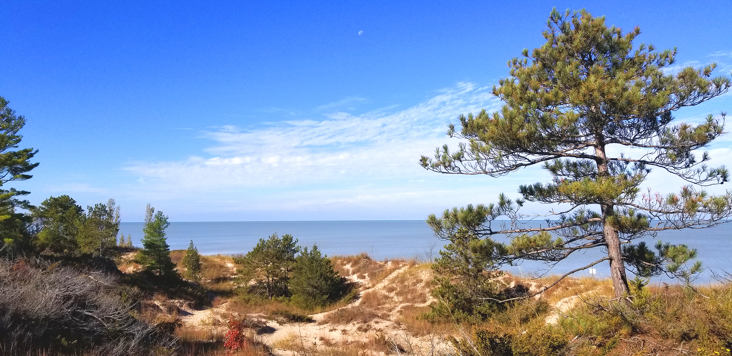
At just over 25 squared kilometres, “The Pinery” has 10 hiking trails, a bike trail and multiple campgrounds. The Old Ausable Channel runs right through the park offering a nice day paddle if you have a canoe, kayak, or stand up paddleboard. 10 kilometres of coastal dunes along the Lake Huron shoreline offer some spectacular sunsets which have been recognized by National Geographic to be some of the best in the world! The park is part of what little remains of the Carolinian Forest here in southern Ontario, notably for rare oak savannah.
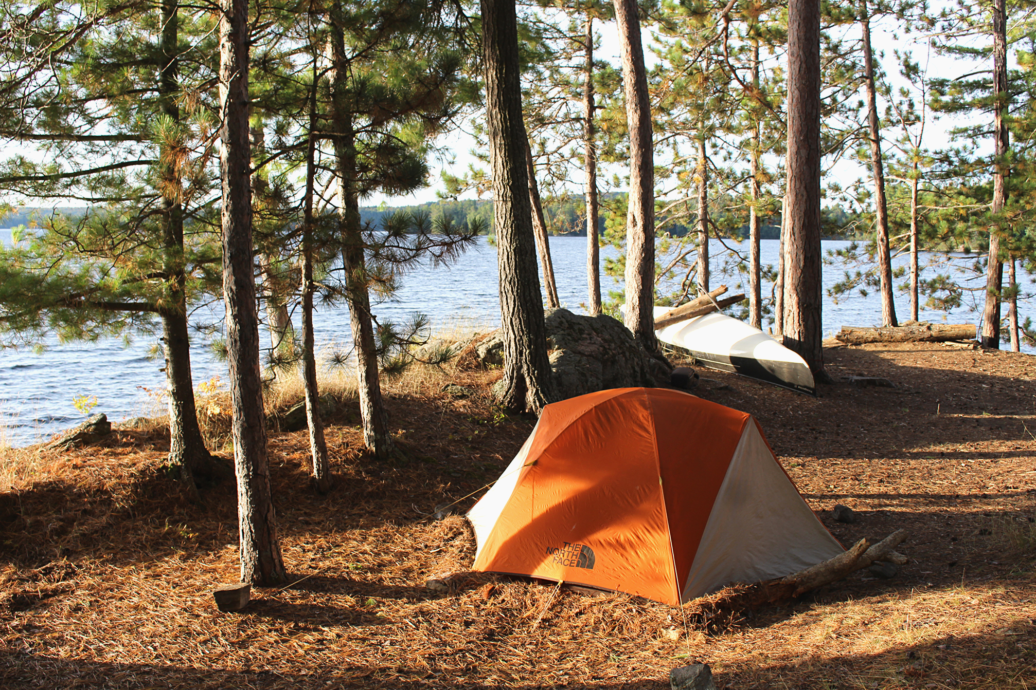
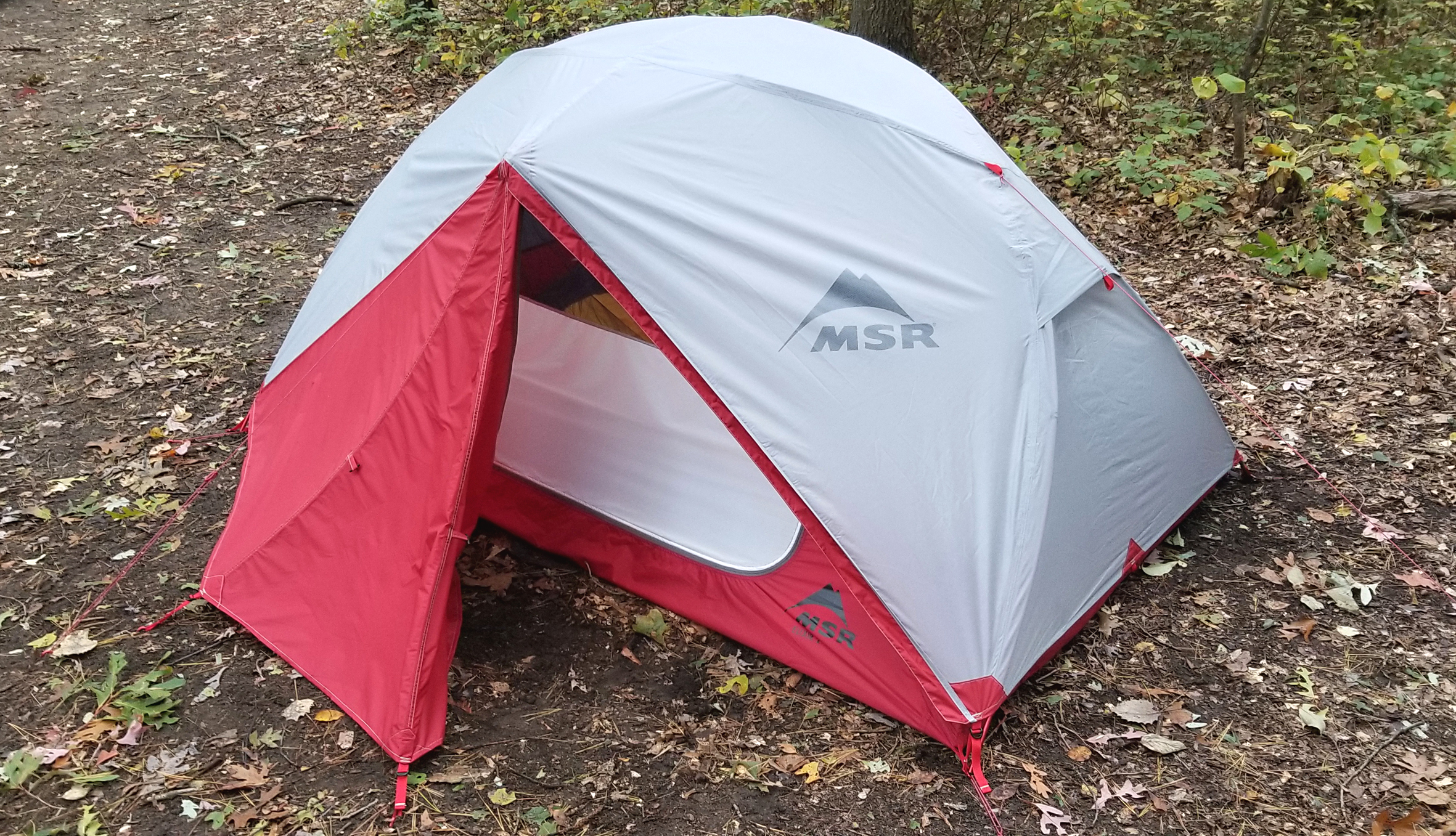
The park is just big enough to offer solitude if we get out on the trails early in the morning. As for camping……well it was okay for a couple who find that even seeing another person is too crowded. We also had another reason to try some camping this weekend, as we bought a new MSR Elixer 2 tent.
Our new MSR Elixer tent. (click image to enlarge)
Day # 1: Home to Pinery Provincial Park – Riverside Area 2 Site #567
Weather:Clear evening. Low: 1 C
As stated earlier, we saw that the weekend forecast looked favourable for camping so we took full advantage by leaving Friday afternoon with a stop in Chatham for a quick supper. We arrived at the park around 6pm, and after setting up the tent we bought firewood. For two bags of firewood along with one bag of kindling cost us $36.00.
Our site was medium sized and completely level. There was a picnic table, and a firepit with a built in grate. We could see our neighbours but we could barely hear their conversations which was nice. A chipmunk once in a while ran up to check us out. No doubt they are well fed here.
Site #567 at Area #2. (click image to enlarge)
Tonight it was clear, calm, and cold. We had a fire and we even had some alcohol which we never bring with us backcountry camping. A Screech-Owl announced its presence nearby.
Our new MSR tent was really easy to put up and we both comfortably fit inside. There are 3 poles to this tent with the 3rd pole allowing us more head room than our old 2 pole tent. The pockets in the new tent are in different locations than our old tent so that is going to get some getting used to.
Day # 2: Pinery Provincial Park – Riverside Area #2 – Site #567
Weather: Sunny and breezy with a few clouds. Clear overnight. High: 14 C Low: 0C
Marianne got chilled last night and had a hard time sleeping until Aaron gave her his sweater. As morning came we were looking forward to breakfast. Camping pancake was on the menu so we brought out our car camping stove and we put the frypan on the one burner for pancake, while the other burner boiled water for tea. Though not as great as it would’ve been in the backcountry, our pancake with peanut butter and homemade strawberry jam was still delicious!
Breakfast pancakes with peanut butter and strawberry jam. (click image to enlarge)
It was a very chilly morning so we layered up. We walked to the Old Ausable Channel and saw a spot where you could rent canoes, though no one seemed to be there yet. By the time we got to the Visitor Centre we were shedding layers. At the Visitor Centre bird feeder we saw White-breasted Nuthatch and a couple of Tufted Titmouse. We walked down the road and hiked the 2.3 kilometre Cedar Trail that brought us through rare oak savannah habitat, some coastal dunes, and before we knew it we arrived at Lake Huron. The lake was really calm and we sat in the sun to enjoy it.
The Old Ausable Channel that runs through the park. (click image to enlarge)Lake Huron and coastal dunes. (click image to enlarge)
As we hiked back to our site we saw many people out enjoying the day. Arriving back at our site we had a quick lunch of GORP, an apple, and some beef jerky. We then walked over to the 2.0 kilometre Nipissing Trail. This was a nice trail with some elevation to it and even a tower where we viewed farm fields and wind turbines to the east, and Lake Huron to the west. In the far distance we heard and then spotted a pair of Sandhill Cranes migrating.
View of farms fields from the tower along the Nipissing Trail. (click photo to enlarge)
It was mid afternoon by the time we arrived back to our site to chill. Aaron had a whiskey and later we wandered around the campground to check out other people’s tents. We definitely had one of the smallest tents, and we were pretty confident we brought the least amount of stuff.
It was sausage and Eggs Diablo with a baguette on the side for supper. We had another fire tonight with some more drinks while the breeze died down almost completely. We were pretty tired after hiking all day se we retreated to the tent before 9pm.
Remember to: Write a review (unfortunately a bad on) on MEC’s website regarding their MEC brand sleeping bag (Mallard -5). One of ours is falling apart already at the seam. -Add 2 guywires to the tent.
Day # 3: Pinery Provincial Park – Riverside Area #2 – Site #567
Weather: A mix of sun and cloud. Morning: 7 C
Surprisingly we got up as late as 7:30am. We went to bed last night at 9:00pm so that means we had a 10 hour sleep. WOW!
We had oatmeal topped with walnuts, homemade strawberry jam, and brown sugar for breakfast. No fire this morning as we burned the rest of our wood last night.
We wanted to go to the 3.0 kilometer Wilderness Trail but the road was blocked off for a run, so instead we drove over to the parking lot next to the Carolinian Trail towards the southwest end of the park. As the name implies, this trail has a lot of trees that are native to the Carolinian forest, with more Tulip Trees than we have probably ever seen! A series of stairs with some viewing platforms and a small pond are also along this trail. We constantly heard and then finally caught a glimpse of some Wild Turkeys.
Pond along the Carolinian Trail. (click photo to enlarge)
Driving back to our site we stopped off at the public washrooms/showers for a nice long shower and then it was back to our site to take down the tent. Two of our 3 neighbours were also breaking camp so it looked like everyone was just out for the weekend. As for our new tent, we were pretty satisfied with it so far!
We left the park around 11:00am and had lunch just outside of Grand Bend before driving home. We had a great time and will come back to Pinery Provincial Park again. Next time we will bring our bikes or our canoe.
Longest Portage: 1.23 kilometres (Kahshahpiwi Lake to Yum Yum Lake)
Average Daytime High: 20.8 Celsius
Average Nighttime Low: 13.4 Celsius
Route: Nym Lake – Batchewaung Lake – Little Batchewaung Bay – Batchewaung Bay – Marian Lake – Jesse Lake – Elizabeth Lake – Walter Lake – Lonely Lake – Sturgeon Lake – Russel Lake – Chatterton Lake – Keats Lake – Shelley Lake – Kahshahpiwi Creek – Heronshaw Lake – Cairn Lake – Sark Lake – Keefer Lake – Kahshahpiwi Lake – Yum Yum Lake – Grey Lake – No Name Lake – Shade Lake – Noon Lake – Summer Lake – Sultry Lake – Silence Lake – Agnes Lake – Keewatin Lake – Kawnipi Lake – Kahshahpiwi Creek – Shelley Lake – Keats Lake – Chatterton Lake – Russell Lake – Sturgeon Lake – Lonely Lake – Walter Lake – Elizabeth Lake – Jesse Lake – Maria Lake – Batchewaung Bay – Little Batchewaung Bay – Batchewaung Lake – Nym Lake
Quetico Provincial Park with our route outlined in red. (click image to enlarge)
Is there any other Ontario Provincial Park that offers as many opportunities for the flatwater canoeist, fisherman, or backcountry camper than Quetico? If there is we haven’t discovered it yet!
Larger than Killarney but smaller than Algonquin, Quetico’s abundance of lakes and portages gives you so so many options when putting together an itinerary. If an unexpected obstacle such as a forest fire blocks your planned route, there are spaced out access points by road and by air so you can divert away from these areas. At 4,719.42 square kilometres, Quetico Provincial Park is large enough to not abandon a trip entirely due to a few closed routes and portages.
On July 29th on the north shore of Russell Lake, a lightning strike started a forest fire. At first the fire was only a mere 80 hectares and looked like it wasn’t going to spread that much, but conditions changed and it grew to 2,800 hectares a couple of weeks before our canoe trip. The fire lead to lake closures including the “B-chain” of lakes (Bisk, Beg, Bud) which was part of our itinerary for our first and last day launching from Stanton Bay. As we approached the week of our canoe trip we decided to modify our route a bit by launching from Nym Lake, paddle west to Sturgeon Lake, and head east to Russel Lake via the 460 metre “staircase portage”. Unfortunately, the easier “Russell Rapids Portage” into Russel Lake was also closed due to the fire.
Besides visiting new lakes and portages, our main objective was to find as many indigenous pictographs as possible. Quetico Provincial Park holds some of the highest concentrations of indigenous pictographs in all of North America. Made with red ochre, pictographs on rock faces are scattered throughout the park. Some are incredibly faded while some are quite vivid. While some of these pictographs are thought to be over 500 years old, others such as an image of a man shooting a gun on Darkwater Lake, are more recent.
Even after changing our route due to the forest fire, we had to modify it yet again during our actual trip due to high winds. Here is our completed route: (map)
Quetico Provincial Park is classified as a “wilderness park”. Expressing that wilderness feel is the lack of portage and campsite signs making trip planning a lot more fun as you pour over maps and online resources to locate campsites and the conditions of portages. Forest fires are also left to burn in the park unless structures are at risk. Fires are monitored and alerts for portage and lake closures are posted on the Ontario Park’s website.
After two days of travel, stopping overnight in both Sault Ste. Marie and Thunder Bay, we arrived at the Dawson Trail Campground off Highway 11 in the park to pick up our permit. We received a couple of garbage bags, and chatted with park staff regarding closures due to the fire, problems with human waste at some campsites, and a report of no nuisance bears this season. We then drove up to the White Otter Inn in Atikokan where we had a bed and a nice hot meal.
Day # 1 Nym Lake Launch to Walter Lake
Weather: Partly cloudy. Windy. High: 21 C Low: 6 C
(click image to enlarge)
We got up early and had our last “real” breakfast at the White Otter Inn before the 15 minute drive down to the Nym Lake launch. Listening to the local weather report we knew that headwinds would be on the agenda today. There was already a light breeze when we launched at 7:50 am.
Early morning at the Nym Lake launch. (click image to enlarge)
Nym Lake is not part of the park and we spotted a few cottages as we headed southwest. A light wind out of the southeast carried the faint smell of burning wood which made sense as the fire was to the southeast of us, though we couldn’t see any smoke.
After the 830 metre portage we entered into the expanse of Batchewaung Lake and into the park where Quetico greeted us with a slap in the face with even stronger headwinds. The first day of our trip was not going to be a day at the beach and our arms got a good workout! After a 160m portage into Little Batchewaung Bay there was a little bit of a reprieve from the winds, though once we rounded the corner into Batchewaung Bay it was a workout again.
Removing our sleeping bags from our packs to reduce drag before paddling into headwinds. (click image to enlarge)
The 310 metre portage into Maria Lake was pretty easy going and we observed three Ruffed Grouse. The next two portages of the day, a 770 metre into Jesse, and a 750 metre into Elizabeth was your typical portage that included some rocky sections. Logs were placed down along both these portages so we assumed they can get quite muddy. Lucky for us (or at least in this regard) it has been a hot and dry summer, so we had no issues with muddy portages this whole trip. Our last portage of the day, a 230 metre into Walter, had a lot of huge blowdowns that had been recently cleaned up. There must have been one hell of a storm to bring down so many large trees!
Typical Quetico scenery along the portages. (click photo to enlarge)
One last struggle with headwinds on Walter Lake and we arrived at the large island site later than we expected at 5:15 pm. This is the only island site that we know of on Walter Lake. The site was mainly out of the wind, with a nice flat spot for a tent, and a large smooth rock for an easy launch with the canoe.
We had enough daylight to relax, pump water, and have a fire big enough to burn our garbage. We saw around 10 people today, which sounds about right since we were only a days paddle from one of the primary launches into the park. Luckily we were also far enough into the park that our site didn’t have any signs of garbage such as toilet paper, a known problem at sites closer to the access points.
Tomorrow we head towards Russell Lake. We wondered if we will smell or see the fire.
Wildlife Sightings: Common Loon, Red Squirrel, Ring-billed Gull, Common Raven, Black-capped Chickadee, Yellow-rumped Warbler, Red- breasted Nuthatch, Ruffed Grouse, Pine Siskin, Blue Jay, People, Bald Eagle
Remember to: No remember to today! Yeah!
Day # 2: Walter Lake to Sturgeon Lake
Weather: Mix of sun and clouds. Windy. High: 23 C Low: 13 C
(click image to enlarge)
Around 5:00 am we woke up to a thunderstorm that thankfully stayed mainly to the north of us. Light rain continued at 7:00 am when we ventured out of our tent, grabbed our cooking supplies, and made oatmeal under the vestibule. We also discovered that our tent was no longer as waterproof as it once was as we could feel the faint spray of rain coming in. Our tent is about ten years old now and we are anxiously awaiting for North Face to release the next generation of the Rock 22.
We had a late start at 9:15 am and made our way south on Walter Lake. The rain stopped shortly after we launched and after the 70 metre and 110 metre portage into Lonely Lake it was sunny again! When we entered Lonely Lake we encountered today’s edition of “The Headwinds” (sounds like a name for a lame backcountry soap opera) and so begun another slog. Even while paddling the creek between Lonely and Sturgeon Lake we experienced headwinds. Two small portages, along with three beaver dam lift overs gave us a chance to stretch our legs before we entered the open waters of Sturgeon Lake.
One of the few calm sections on this morning’s paddle. (click photo to enlarge)
Sturgeon Lake is one of our favourite Lakes. It’s a larger lake with a lot of character including hills, islands, and even a sandy beach. It can also get some pretty wicked waves when windy. As we entered Sturgeon Lake and turned the canoe eastward, we also got to experience sideways winds. Though not as slow going, the sideways winds were harder on Aaron’s shoulders as he steered from the stern.
Our original plan was to get as far as McDougall or Keats Lake, but it was already 3:00 pm when we arrived at the Sturgeon Narrows. Paddling up the narrows we found a site on a small point along the eastern shoreline. It was an average site with three dangerous widow makers, while the seating area around the firepit was also in need of some work. If we were to stay here for more than a single night we would have taken the time to fix it up.
Our site at the Sturgeon Narrows on Sturgeon Lake. (click photo to enlarge)
We are now three kilometres away from the Russell Lake fire. We can’t smell anything and hope that last night’s rain helped contain it more.
Chili was on the menu for tonight’s supper, and we had a few mosquitoes as unwelcomed dinner guests. After sunset a small swarm of mosquitoes hung around and we retreated to the tent while we listened to their high pitched whining for blood on the other side of the tent.
Wildlife Sightings: People, Canada Goose, Boreal Chickadee, Red Squirrel, Red-breasted Nuthatch, Yellow-rumped Warbler, Common Loon, Bald Eagle, Red-tailed Hawk, Belted Kingfisher, fish species.
Remember to:Our tent is no longer as waterproof as it once was. Probably time to invest in a new one soon.
Day # 3: Sturgeon Lake to Heronshaw Lake
Weather: Partly cloudy. Windy. High: 24 C Low: 12 C
(click image to enlarge)
As we poked our heads out of the tent this morning we were greeted with beautiful calm skies. For breakfast we had warm granola cereal with dried cranberries, dehydrated apples, and brown sugar. A hot tea is always a must for us first thing in the morning.
Calm sunrise on the Sturgeon Narrows. (click image to enlarge)
We left our site at 8:00 am and made our way to the 460 metre “Staircase Portage” into Russell Lake. Unfortunately, the easy 80 metre “Russell Rapids Portage” at the north end of the Sturgeon Narrows was off limits due to the fire. This was the second time we have done the “staircase”, the first time back in 2014 when we did the Hunter Island Loop. The portage itself isn’t that bad with the steep slippery rock section at the Sturgeon Lake end, and it was certainly slippery this morning!
It was a sunny and calm paddle as we crossed Russell Lake. A nice sandy beach met us at the 390 metre portage into Chatterton Lake. While doubling over we met a group of guys that were just arriving at the portage from Russell Lake as well. Two of them were from Chicago and their friend was from Australia. With the forecast calling for wind today we decided to forego viewing Chatterton Falls which was just around the corner at the put in into Chatterton Lake. We will be back through this section in about a week so we will check then out then.
Winch we found hanging at the Russell Lake portage. Possibly a relic from the logging days. (click image to enlarge)
As we began to paddle Chatterton Lake, an over the shoulder look to the northwest revealed charred trees along the far northern shore, but no smoke. Perhaps the forest fire is just smoldering now?
The forecasted winds began to pick up from the south while we were on Chatterton Lake. At the 450 metre “Split Rock Falls” portage we met four more people. They were a group of guys that were flown into Cache Bay and were being picked up at the Nym Lake launch at the end of their trip. The Split Rock Falls portage is neat with ascending and descending sections. There is also a spot where you have to almost jump from a huge rock to another huge rock as you make your way to the put in above the falls. Adjacent to the falls there was a couple of spots to put in the canoe and we chose the spot furthest away from the strong current.
As we made our way east on Keats Lake we heard and later observed Snake Falls, while beside it to the north is the 290 metre “Have a Smoke Portage”. The landing was very rocky here so Marianne got out from the bow of the canoe and pulled it ashore. We have yet to find out how the “Have a Smoke Portage” got it’s name. The only suggestion we have come across online is that it is okay to have a smoke here as it is an open area with so many rocks around. We both don’t smoke so we didn’t bother.
Rocky takeout at the beginning of the “Have a smoke portage”(click image to enlarge)
Strong winds met us on Shelley Lake and Kahshahpiwi Creek was a wind tunnel! It was already past mid afternoon when we were met with the challenge of finding the portage into Heronshaw Lake. We knew the portage was labelled wrong on the Fischer Map, and standing in the rocky shallows of Kahshahpiwi Creek it was difficult to tell how far down the creek we actually were. With low water levels we carried everything further south until it was deep enough to paddle again, and soon we located the portage that was around a corner. The portage itself was an easy 200 metres and it probably took us just as long to portage it as it did to find the darn thing!
The headwinds were relentless as we entered Heronshaw Lake and would be the worse headwinds we were to experience for the whole trip. We wanted to get to Cairn Lake by this evening but these winds were getting downright dangerous! We slowly made our way to a swampy island which we thought was the location on the map where Marianne labelled a campsite, but when Aaron turned on the GPS (we try to use this as little as possible) we were off by just one island. We arrived at our island site around 6:15 pm which gave us just enough time to put up the tent, pump water, have a couple of Kind Bars, bath, and brush our teeth. After sunset it was still windy, but luckily our tent was sheltered amongst the trees with no widow makers nearby. Listening to our windup weather radio we were also under a severe thunderstorm watch. We really hope the storms stay away!
Wildlife Sightings: Bald Eagle, People, Common Merganser, Boreal Chickadee, Red-breasted, Common Loon, Belted Kingfisher, Northern Flicker, fish sp., Pileated Woodpecker, Pine Siskin, Spotted Sandpiper
Remember to: No remember to today. Yeah!
Day # 4: Heronshaw Lake to Kahshahpiwi Lake
Weather: Sunny and cloudy in the morning with increasing clouds and a thunderstorm in the afternoon. High: 24 C Low: 18 C
(click image to enlarge)
Strong winds continued all night, though by morning we were pleasantly surprised that they calmed down completely.
View from our tent on Heronshaw Lake. (click to enlarge)
It was very still when we got out of the tent and we located the firepit at the highest point of the entire site which was a great spot as long as it wasn’t windy. We were a little behind schedule so it was a quick breakfast of Kind and fruit bars with tea, and by 8:00 am we were off again paddling south.
Breakfast at the top of our site on Heronshaw Lake. (click image to enlarge)
This morning Heronshaw Lake was so calm compared to yesterday’s strong winds. We felt like we were at a totally different lake as nothing was familiar to what it was a mere 8 hours ago.
After a 170 metre portage we soon entered Cairn Lake and WOW was it ever a beautiful lake! In fact, all of today’s lakes as we entered the heart of Quetico were picturesque with views of rocky islands. Another trip is in order to spend more time exploring this section of the park!
Falls along a portage. (click to enlarge)
The sun played hide and seek with the clouds this morning, and later dark blue and soon to be ominous looking clouds began to dominate the sky. It continued to get warmer as we entered Sark Lake, followed by Keefer Lake, and the air was also very still which is a good recipe for severe storms.
Along our travels today we met a group of canoeists from Iowa, and a soloist from Minnesota heading to Kawnipi Lake that was out for a whole three weeks! For us a three week trip anywhere would be a dream, but to do it solo….I don’t think either of us have the constitution to do so.
Our last lake of the day was Kahshahpiwi Lake. The name Kahshahpiwi comes from the Ojibwe meaning “the lake that flows continuously” which makes sense as the route paddled and portaged goes right through the Hunter Island area. As we paddled south we could see that there was once a fire along the eastern shore (from we believe 2006) with new growth already filling in the gaps of scorched earth. We also saw an old fire tower far up on the western shore on the opposite side of the lake which is now apparently a communications tower.
Eastern shoreline along Kahshahpiwi Lake, the result of a forest fire from 2006(?) (click image to enlarge)
We made it to a site on a large peninsula around 2:30 pm. The site had a nice spot to bath and launch and an okay seating area at the fire. As soon as we arrived we quickly put up the tent as the skies continued to look ominous. It was quite humid now and we took a quick bath to cool ourselves and wipe the stink off. While Marianne was bathing she felt a couple of quick stabs on her toe. Looking down she saw a crawfish that was apparently not impressed with us invading on its turf.
We were thinking about paddling around the corner to look for the pictographs located on the lake’s southwestern shore but rumbles of thunder boiled over in the distance, so instead we gathered our things and retreated to the tent. It didn’t take long before the thunderstorm was right on top of us with lots of lightning and sometimes very close thunder! It lasted for about an hour and we were happy that no strong winds were associated with it. We were also thankful that it rolled through leaving us just enough light to have a real supper of Sheppard’s pie with stuffing. YUM!
We had to dig a small trench to prevent the rain from going into the tent. (click image to enlarge)
After pumping water we played the card game war in the tent as night fell. We actually had a hard time even finishing the game and had to quit after an hour because neither of us could get rid of all our cards!
Wildlife Sightings: Black-backed Woodpecker, Boreal Chickadee, Canada Jay, Crawfish, Common Raven, Herring Gull, Common Loon, Northern Flicker, Red-breasted Nuthatch, Belted Kingfisher, People, Bald Eagle, Fish species, Red Squirrel
Remember to:No remember to today! YEAH!
Day # 5: Kahshahpiwi Lake
Weather: Partly cloudy. Windy. High 23 C Low: 18 C
(click image to enlarge)
Probably one of the most essential items we use on any backcountry camping trip is our windup solar powered radio. Not only is there some unique local stations such as NPR and CBC to listen to, but the weather band can literally dictate our next move. 50 kilometre per hour wind gusts were predicted for today, so we decided to make today a wind bound day, the first of two we allotted for ourselves for the whole trip.
The calm side of Kahshahpiwi Lake. (click image to enlarge)
We began our lazy day by preparing hot coals on the firepit for a pancake. As with almost all of our backcountry pancakes, this one would be topped with peanut butter and jam! The entire morning consisted of chilling by the lake out of the wind while listening to NPR radio.
Pancake in the backcountry is always a delight! (click image to enlarge)
Today was also laundry day so we washed our clothes and layed them in the sun to dry, moving them every so often as needed to keep them in the sun. Around noon we saw a low flying float plane and we wondered if they were looking for someone or maybe picking someone up.
Exploring behind the site, Marianne flushed a Ruffed Grouse, and saw a Black-backed Woodpecker working on one of the dying trees. Aaron chilled in the tent and read the SAS Survival Guide. After a couple of Mountain House meals for lunch, we looked over our route on the map. These past windy days, with this one in particular, has left us a little behind schedule. We decided to shave off some kilometres to our route by taking a shortcut into the middle of Agnes Lake via Noon Lake to Silence Lake, instead of heading south all the way to Burke Lake and entering the Agnes Lake from the south. Unfortunately this would mean missing Louisa Falls which is too bad because the falls have a natural jacuzzi, and in these warm temperatures would have been lovely!
Though it was another warm afternoon the winds kept it feeling a little cooler. We were lucky that most of our site, tent included, was protected against the strongest winds. We took another quick bath in the lake and got our gear ready for tomorrow. We placed tomorrow’s food in our little travel backpack so we don’t have to dig into the main packs at first light tomorrow.
A homemade rehydrated meal of spaghetti with tomato sauce was in the pot for tonight’s supper. No thunderstorms today which was a nice change.
Wildlife Sightings: Common Loon, Dark-eyed Junco, Northern Flicker, White-throated Sparrow, Golden-crowned Kinglet, Red Squirrel, Ruffed Grouse, Black-backed Woodpecker, Common Raven
Remember to:Mark known campsites on adjacent lakes, not just those on our planned route, just in case we have to reroute our trip.
Day # 6: Kahshahpiwi Lake to Agnes Lake
Weather: Light showers in the morning with a mix of clouds and sun in the afternoon. High: 25 C Low: 21 C
(click image to enlarge)
This morning we got up by 5:30 am to get a head start on the day. We were on the water by 7:30 am and made our way to the southern most end of Kahshahpiwi Lake to check out the pictographs along the cliff. Though there was supposed to be two sets of pictographs along this cliff we were only able to locate the one that had an image of a turtle.
Cliff where pictographs are located on Kahshahpiwi Lake. (click image to enlarge)Kahshahpiwi Lake pictographs that includes a turtle on the right. (click image to enlarge)
After heading back around the peninsula we made it to the longest portage of the trip, the 1,230 metre “Yum Yum portage”. As with most named portages, this one had some character to it. The Yum Yum portage is rugged, steep, and even has a huge slab of rock on a 40 degree angle that requires you to push the canoe down first and then slide down on your butt afterwards. It was a workout for sure and we got our sweat on. We had a little bit of light rain this morning and we were happy that the rocks along this portage were not particularly slippery because if they were the portage would have been a lot more difficult!
So what is so yummy about the Yum Yum Portage and the adjacent Yum Yum Lake? Well nothing actually. Yum Yum is the character in a play called “The Mikado” and Yum Yum was the name of one of the characters in the play. There is also a character named Koko (Koko Falls is part of the Falls Chain in Quetico), and another character named Poohbah, another lake name in the park.
Very steep section along the Yum Yum portage. (click photo to enlarge)
The next portage, a 580 metre into Grey Lake actually felt longer than the following 720 metre from Grey into the unnamed lake. Perhaps this was because it was more rocky which slows you down a bit.
The 720 metre portage from Grey to the unnamed lake has gained some fame of its own as you have to go through close to a hundred metres of boot sucking bog in the middle of the portage. Logs are placed down in the middle of the bog to walk on but apparently they are not always stable, and people have slipped off only to land up to their waists in muck! We knew this going in, but thanks to a hot and dry summer we could actually walk beside the logs only sinking an inch at most.
The muddy section along the unnamed portage was not as bad as we thought. (click image to enlarge)
Another lake we will have to return to on a future trip is Shade Lake. We paddled past a few campsites and from the canoe they looked really nice! We took a quick detour to check out some pictographs which were symbols of thunderbirds. Interestingly they were quite high up form the waterline.
Abstract thunderbird symbol on Shade Lake. (click image to enlarge)The other abstract thunderbird symbol on Shade Lake. (Click image to enlarge)
Along the portage to Noon Lake we met a couple of young canoeists and another two paddling on Noon Lake. Both were coming from Reid Lake on their way to Shade Lake for the night. Reid Lake is named after Paul Reid, a pioneer in Canadian aviation who flew forest fire detection patrols in Ontario, mapped some of the northern frontier in Canada, and survived twice when others gave him up for dead. Why is this even mentioned when we haven’t even visited this lake?, because Marianne’s maiden name is Reid so she had to boast.
Back to our actual trip it was also around this time, after meeting these two groups of guys from Reid Lake, that Marianne realized she hasn’t seen another girl since day one of our trip. After a few more short portages through Summer, Sultry and Silence Lake, we entered Agnes Lake. Before entering Agnes Lake we turned around and saw a wall of grey clouds creeping up behind us from the west, so rain on it’s way yet again. Paddling up the western shoreline of the large Agnes Lake we found the park’s only known petroglyph, which depicts either four caribou or deer. A short 50 metre paddle north of that and we saw another pictograph. This one was an image of two rabbits, though only one of them is recognizable.
The only known petroglyph in Quetico depicts either four caribou or deer. This was created by scratching the surface with a blunt tool. (click image to enlarge)Two rabbits pictograph on Agnes Lake. (click image to enlarge)
Paddling north and east we approached our large island site at around 6:00 pm. Today was a long and successful day! We set up the tent, quickly bathed, pumped water, and had a homemade dehyde of veggies, egg noodles, and parmesan cheese. A pair of Canada Jays investigated our meal but they were not interested in any handouts.
Just after sunset we got a small fire going with thunderheads in the south, now glowing pink from the sunset, travelled from the west to the east. After sunset the clouds turned a darker shade of blue and once in a while we saw lightning dancing from cloud to cloud with very distant rumbles of thunder. We were glad they remained to the south.
Our tent in a sheltered spot at our site on Agnes Lake. (click image to enlarge)
Wildlife Sightings: Common Loon, Red Squirrel, Chipmunk species (either Least or Eastern), Canada Jay, Boreal Chickadee, Bald Eagle, Ruffed grouse, Canada Geese (migrating south), frog species, Pine Siskin, Yellow-rumped Warbler, Black-capped Chickadee, Red-breasted Nuthatch, Common Raven, People.
Remember to: No remember to today! Yeah!
Day # 7: Agnes Lake to Kawnipi Lake
Weather: Light rain in the morning with clouds the rest of the day. High: 20 C Low: 14 C
(click image to enlarge)
BOOM! At 2:30 am a thunderstorm rolled through with lots of thunder, lightning, and heavy rain. We did not get much sleep that night.
Light rain continued at 7:00 am when we got out of the tent to have a hot breakfast of “Super Awesome”(Bob Red Mill Mighty Tasty Hot Cereal) with dried cranberries and brown sugar on top, and a hot tea. Finally by 10:00 am the rain stopped and we slid the canoe back into Agnes Lake.
Just around the corner from our site is another great pictograph site. This one had a bear, an abstract shape, two people in a canoe, and two Maymaygwayshi in a canoe. The Maymaygwayshi to the Ojibway people were short hairy-faced mischievous little men who lived along the waters of rivers.
Our original plan was to take a short side trip to Ahsin Bay on Payne Lake to check out those pictographs as well, but a late start to the day made us skip this side trip. We actually didn’t see anyone during our whole time paddling Agnes Lake which we thought was somewhat strange.
Canoe and hand smears pictograph on Agnes Lake. (click image to enlarge)Two Maymaygwayshi in a canoe. (click image to enlarge)
Bear and abstract pictograph. (click image to enlarge)
Our portages, which were three in total (at 310 metres, 330 metres, and 460 metres), were relatively flat but quite rocky. While silently paddling north on Keewatin Lake Aaron spotted three River Otters who came to the surface periodically making interesting chirping noises. Also on Keewatin Lake we saw two sets of pictographs which included a fat moose and some thunderbirds.
Stick animal and fat moose pictograph and Keewatin Lake. (click image to enlarge)Thunderbird pictograpgh. (click image to enlarge)This set of pictographs on Keewatin Lake is hard to make out. The farthest left and right images appear to be thunderbirds. The one in the middle at the top looks like 2 people in a canoe with the right side faded. The middle pictograph looks like a cross. The bottom image looks like a skinny deer or moose. (click image to enlarge)Location of the pictographs on Keewatin Lake. (click image to enlarge)
After the 460 metre portage we entered Kawnipi Lake. Here the forest had more deciduous trees with some fall colours beginning to show.
View from the portage at the end of Keewatin Lake. (click image to enlarge)Quick lunch berak at the end of Keewatin Lake before tackling the portage. (click photo to enlarge)
We paddled to the far northwest end of Kawnipi Lake without seeing a single soul since we began our day. According to our Fisher Map there were supposed to be some pictographs around this area but we couldn’t locate them nor the campsite that was supposed to be right beside them on the eastern shoreline. We continued to paddle northwest on Kawnipi Lake to look for a site at the more shallow end of the lake. The first site we examined wasn’t to our liking so we paddled to a small site on an island next to a shallow marsh. This site was also mediocre with lots of downed trees and it was completely infested with mosquitoes! Today was the first day we had to break our the bug spray.
Not the greatest site on Kawnipi Lake. (click image to enlarge)
The mosquitoes did not deter us from getting some hot coals going in the firepit to make bannock with rehydrated black bean hummus pooped on top for flavour. After pumping water it was a quick rush to the tent and murder any incoming mosquitoes. While playing cards by the light of a hanging headlamp we heard the distant rumble of thunder to the north, though we just got a few sprinkles of rain.
Wildlife Sightings: Common Raven, Common Loon, Bald Eagle, Yellow-rumped Warbler, River Otter, Pileated Woodpecker, Red-breasted Nuthatch, Red Squirrel
Remember to: Mountain House Pasta Primavera tastes better than Back Packers Pantry version.
Day # 8: Kawnipi Lake to Chatterton Lake
Weather: Mainly sunny. Windy in afternoon and into the evening. High: 25 C Low: 15 C
(click image to enlarge)
BOOM! At 1:00am another storm rolled through with lots of rain and lightning. This is by far the most thunderstorms we have ever had on a canoe trip! Maybe even all of them combined!
This morning we woke up at 6:30 am, and in a hail of mosquitoes we quickly took down the tent, packed up our stuff, and got the hell off of that island! The mosquitoes hung out with us in our canoe to almost our first portage, an 80 metre back into Kahshahpiwi Creek. We are now beginning to retrace our route.
As we continued west we returned to the 290 metre “Have a Smoke Portage” and took a small break to take photos of the falls.
Marianne at the end of the “Have a smoke portage”. (click image to enlarge)
Continuing west we looked back at Snake Falls. Our plan was to camp on McDougall Lake but the 290 metre portage out of Keats Lake was way too steep and looked like it hasn’t been used lately, so we headed north to the 450 metre “Split Rock Falls” again. It was along this portage we noticed that the forecasted winds were beginning to pick up. We continued northwest and said “screw you winds” giving up on McDougall Lake altogether and settled instead for a site on lower Chatterton Lake. This site was another one that Marianne discovered online and drew a dot on the map. We arrived around 2:00pm and it was a really nice site! It’s on a peninsula with a nice flat spot for a tent and at the shoreline are large flat rocks to stand on while you rinse off in the lake. We were just south of the “No travel/camping” area due to the forest fire which was about 3 kilometres to the northwest of us.
The view from our site on Chatterton Lake. (click image to enlarge)
Taking advantage of the warm sunshine we bathed, washed our clothes, and hung them up on a clothesline. The winds were getting quite gusty and as a minor inconvenience every so often we had to pick up a piece of clothing that fell off the clothesline. For the rest of the windy hot afternoon we retreated to the shelter and shade of the tent and played a round of UNO before we had supper which consisted of homemade rehydrated chili with a cool and sweet side of Gatorade.
Laundry day at our site on Chatterton Lake. (click photo to enlarge)
The winds finally died down in the evening and while Aaron was pumping water, Marianne spotted two guys in a canoe heading west right before sunset. They probably had to wait out the headwinds and were paddling until dark.
Wildlife Sightings: Osprey, Bald Eagle, Frogs, Black-capped Chickadee, Red-breasted Nuthatch, Common Loon, Red Squirrel, Belted Kingfisher, Garter Snake, People
Remember to: Without having breakfast, it takes an hour to break camp.
Day # 9: Chatterton Lake
Weather: A mix of sun and clouds. Windy. High: 14 C Low: 13 C
(click image to enlarge)
Around midnight we woke up to the sound of wind. Aaron quickly went out of the tent to add rocks to the canoe to prevent it from rolling over. From that point on we didn’t have the most restful sleep.
When we noticed dawn was approaching it became painfully apparent that we were not going anywhere today. The temperature also dropped and for the first time this trip we felt a little chilled in the tent. We finally got out of the tent around 10:00 am and had honey granola with rehydrated apples for breakfast, along with a nice hot tea.
A couple of paddlers were out on the water this morning and lucky for them they had a pretty nice tail wind to help them to their next destination. We have yet to experience that kind of luck on this trip.
We just chilled around the site today. We moved and rebuilt the fire pit in a more appropriate spot on a bare rock where it looked like it used to be until someone else moved it. We also improved it even further by gathering more rocks to build a back wall. Most of the rocks were close to the lake so we got our daily exercise when we lugged them up to our site from the shore.
Creating an epic fire pit at our Chatterton Lake site. (Click image to enlarge).
Towards the late afternoon the winds finally settled down a bit, though too late in the afternoon for us to paddle. Far to the west in the distance we spotted a solo paddler making his way towards us. Marianne grabbed her binoculars and saw that it was the same solo paddler we met prior that was out for three weeks. Upon seeing Marianne he came to shore and we had a good chat. He ended up spending a few days on Kawnipi Lake and checked out the Falls Chain. He was in very good spirits as he still had a whole week left on his trip. He also gave us some valuable information that the Russell Rapids was opened again for travel as the fire subsided enough to allow passage through that area. This was great to hear as we wouldn’t have to do the dreaded “Staircase Portage” again.
A flock of Yellow-rumped Warblers hung out around our site for most of the day, possibly fueling up before they begin their fall migration. Speaking of fall migration, it appeared that the avian floodgates were now opened as we saw at least five lines of Canada Geese throughout the day. This was the first day we observed migrating geese, no doubt due to the change in temperature.
As night fell we had nice big fire in our epic fire pit. Overhead in the distance we heard more geese migrating. It was then that we realized that our trip, and summer for that matter, was almost over.
Wildlife Sightings: American Crow, Yellow-rumped Warbler, Palm Warbler, Golden-crowned Warbler, Black-capped Chickadee, Red Squirrel, Canada Jay, Red-breasted Merganser, Yellow-bellied Sapsucker, Common Loon, American Robin, Belted Kingfisher, Canada Geese (migrating south), Bald Eagle, People
Remember to: No remember to today!
Day # 10: Chatteron Lake to Jesse Lake
Weather: Foggy in the morning. Partly cloudy skies for the rest of the day. High: 15 C Low: 8 C
(click image to enlarge)
Go time this morning! All rested we got up at 5:30 am, had a quick tea with some Kind Bars, and were back on the water by 7:15 am. It was a calm and foggy morning and the air was a lot cooler than the water as we could feel warm air rising off of it. We paddled northwest to the 390 metre portage into Russell Lake. The morning fog created a damp mist which left us slightly chilled as we paddled.
Foggy morning from our site on Chatterton Lake. (click image to enlarge)
Along the portage from Chatterton to Russell Lake we viewed a huge 100 foot, 4 metre in diameter pine tree. Entering Russell Lake we had a pretty descent view of the bottom of Chatteron Falls, but once again we decided to skip checking out the top of the falls. Maybe next trip? Paddling northwest on Russell Lake we saw a tent on an island site and we paddled past the site we stayed at in 2014 when we did the Hunter Island Loop.
Soon the unmistakable scent of burnt wet wood reached us as we headed very close to where lightning struck back on July 29th on the north shore of Russell Lake. In the far distanced through the fog and mist we saw charred trees. We decided not to go out of our way for a closer look and continued towards the Russell Rapids portage.
Charred trees barely visible through the fog from the Russell Lake fire. (Click image to enlarge)
As we approached the portage we saw a sign saying that it was still closed. Maybe no one had a chance to take it down yet? Sign or no sign we could clearly see we were not in any danger so we portaged the easy 80 metres while the Russell Rapids babbled beside us.
Closed portage sign at the portage to Sturgeon Narrows. (click photo to enlarge)
Sturgeon Narrows was delightful and calm as we made our way south. The continuing mist left us a little damp and chilled, but not enough to bother with the rain gear. When we came out of the narrows and entered the wide expanse of Sturgeon Lake we remarked that we have probably never been on this lake when it was this calm before. When we were here a few days ago we battled sideways winds, and now it felt like a new lake for the trip as it looked a lot different. We continued to paddle west, not straying far from the north shore so as not to miss the marshy area to a creek that heads back to Lonely Lake.
A single lift over a beaver dam, along with two more between Lonely and Walter Lake, we entered Walter Lake and paddled past our island campsite from earlier which appeared unoccupied. Returning to the 230 metre portage between Walter and Elizabeth Lake, through the section of huge blowdowns, we wondered how long it took park staff to clear up what may have been impassable at one point.
At the put in on our way to Jesse Lake. (click image to enlarge)
We decided to camp on Jesse Lake with our sights set on an island site. For the first time on this whole entire trip the site that we wanted was actually occupied. We then turned and headed towards the site closest to tomorrow’s portage. This site had smooth rock all away around the water’s edge that made for an easy take out. However, the rocks were incredibly slippery with a layer of organic matter making bathing anywhere really difficult. To pump water to drink we had to go out in the canoe away from the shore as to not clog up the filter.
Our Jesse Lake site. (click photo to enlarge)
Tonight we chilled at our site and listened to some CBC Radio. Another flock of geese migrated over. Supper this evening was Mac n’ Cheese with some vacuum packed tuna that Aaron picked up while in the United States.
Evening from our site on Jesse Lake. (click photo to enlarge)
Wildlife Sightings: Red Squirrel, Boreal Chickadee, Black-capped Chickadee, Canada Jay, Black-backed Woodpecker, Hairy Woodpecker, Pileated Woodpecker, Bald Eagle, Common Loon, Ruffed Grouse, Frog sp., fish sp., Red-breasted Nuthatch, Golden-crowned Kinglet, Canada Goose (migrating), American Pipit (migrating), Turkey Vulture, People, Dark-eyed Junco
Remember to: Pink Lady apple variety can stand two weeks of being in a backpack with hardly any bruising.
Day # 11: Jesse Lake to Nym Lake Launch
Weather:Foggy with sun and clouds in the morning. High: 15 C Low: 9 C
(click image to enlarge)
Aaron woke up cold this morning as we were not yet climatized to real fall temperatures. We exited the tent around 6:00 am, had the last of our tea, along with the last of our honey and granola cereal topped with strawberries we dehydrated from our garden back home.
Foggy morning Jesse Lake. (click photo to enlarge)
We launched into the fog around 8:00 am. We were very fortunate that we had calm cloudy skies. In fact, we had calm waters for the whole morning! On Batchewaung Bay we met the only other couple out on a canoe within our sites, and we passed another couple just getting ready to take to the water themselves at the site on Mosquito Point.
While on Batchewaung Lake we both had to take a quick pitstop to stretch our legs. We decided to check out what we were told was a 5 star campsite. No one was there and as we got out and looked around we could see why this site had 5 stars! There were multiple spots for tents, a pretty nice fire pit, and a gradual slope to the lake. It was probably one of the nicest sites we have ever seen! As we got to our last portage, from Batchewaung Lake to Nym Lake, thus taking us out of the park, we took one last look and waved goodbye to Quetico. We really didn’t want to leave, but a nice hot shower was beckoning.
Entering Nym Lake the landscape changed immediately with cottages and a few homemade lighthouses dotting the shoreline. Entering Nym Lake from the portage on a clear day it is possible to vaguely see the green Ontario Parks sign that guides paddlers back to the launch on the lake’s north shore.
The most depressing photo of the whole trip. Our return to the launch. (click to enlarge)
As we returned back to the launch and climbed up the stairs to the parking lot we saw fewer cars than when we started with most from the United States. A trio of Canada Jays foraged along the parking lot as we loaded the canoe on the car and phoned/texted our contacts that we made it out okay.
Back to the town of Atikokan and the White Otter Inn for supper. On the drive back to the Trans Canada Highway we flushed our first Spruce Grouse of the trip. Before checking into the Inn (we were a bit too early), we stopped in at Robin’s Donuts for some apple fritters and a coffee.
If there is one thing Quetico Provincial Park teaches us every time we go is that the winds will always dictate the outcome of a trip, especially on the larger lakes. Luckily Quetico has enough lakes and portages to make an alternate route possible if you have to suddenly change your route mid trip.
This is truly a paddlers paradise and we will be back again as we have A LOT more lakes, pictographs, and portages to discover!
Wildlife Sightings: Canada Jay, Common Raven, Bald Eagle, Common Loon, Common Merganser, Turkey Vulture, Boreal Chickadee, Black-capped Chickadee, Hermit Thrush, American Robin, Golden-crowned Kinglet, Canada Geese (migrating south), Spruce Grouse, Pepople, White-tailed Deer (Atikokan)
Christmas and Boxing Day fell on a Monday and a Tuesday which gave us an extra long weekend to spend the holidays up in Algonquin Provincial Park. We booked a yurt back in July at the Mew Lake campground which is along the main highway 60 corridor. On December 22nd we packed up the car with warm clothes, lots of food, Christmas cookies, and spent the night with family near Orillia.
Yurt #62 at the Mew Lake Campground in Algonquin Provincial Park. (click photo to enlarge)
Day #1: Mew Lake Campground Yurt #62
Weather: Cloudy. High: -6 C Low: -6C
We made our way east down highway 60 after having lunch in Huntsville, and entered Algonquin Park in the early afternoon. Our first stop was the Visitor Centre for a second coffee, and to check out their bird feeders. The birdfeeders here are popular with birders, and if you can’t make the trip up there is even a live webcam that you can check out through the Friends of Algonquin Park website. We learned that a Pine Marten also frequented the birdfeeders but it didn’t show up while we were there. While standing on the large observation deck from the back of the visitor centre we saw Red-breasted Nuthatch, Hairy Woodpecker, Blue Jay, Black-capped Chickadee and a White-winged Crossbill.
It was too late in the day to start a trail so we decided to drive to the Mew Lake campground, pick up our permit for the yurt, and unpack. The yurts at the Mew Lake are comfortable for winter camping and are equipped with 2 bunkbeds, a table, 6 chairs, and an electric heater. After unpacking and organizing our stuff we played cards and read the park newspaper. Supper tonight was a ham sandwich, macaroni and tuna, pumpkin pie and some Christmas cookies.
Inside our yurt. (click photo to enlarge)
It was early to bed as we have a big day of hiking trails tomorrow! Testing the snow it was clear that snowshoes were not needed so we left them in the car.
Wildlife Sightings: Red Squirrel, Red-breasted Nuthatch, White-winged Crossbill, Hairy Woodpecker, Blue Jay, Common Raven, Black-capped Chickadee, Purple Finch, People.
Remember to: Bring slippers to wear in the yurt. Bring a wash basin for dishes.
Day # 2: Mew Lake Campground: Hardwood Lake Lookout Trail (0.8 km), Peck Lake Trail (2.3 km), Hemlock Bluff Trail (3.5 km)
Weather: A mix of sun and clouds with snow in the evening. High: -6 C Low: -13 C
We got up before 7 am and fried up some bacon and eggs, a side of potatoes, and a slice of pumpkin pie. Doing dishes without a wash basin was a pain in the butt but we managed.
We grabbed our day bag, hopped in the car, and drove to the Hardwood Lookout Trail. At 0.8 kilometres in length, it was a nice hike with a scenic lookout over Smoke Lake. Wildlife highlights included some Ruffed Grouse basking in the morning sun high up in tree. Aaron received a phone call from work so while he was in the car Marianne hiked the adjacent Red Spruce Side Trail. The Red Spruce is a rare species of tree in Algonquin, only located in small areas in the park’s west side and in the neighbouring Haliburton County in all of Ontario.
Smoke Lake along the Hardwood Lookout Trail. (click image to enlarge)
Our next trail was the easy 2.3 kilometre Peck Lake Trail which goes around the small lake. In the freshly fallen snow we could make out some small animal tracks.
After this hike we returned to the yurt for a quick lunch of macaroni salad and Chirstmas cookies. We also had to take off our winter clothes while having lunch as we were already sweating. Marianne placed some seed out on the picnic table ouside which attracted Blue Jays, Black-capped Chickadees, Red Squirrels, and a Wild Turkey.
The Hemlock Bluff Trail at 3.5 kilometres was our last trail for today which had both coniferous and deciduous trees. We observed a Black-backed Woodpecker along this trail and a tree that had the tell tale signs of a Pileated Woodpecker. As with many of Algonquin’s trails this one also had a scenic lookout. This scenic lookout was over Jack Lake.
We returned to the Mew Lake campground around 3pm and had a quick shower at the comfort station. Supper was soup and some chocolate cake. We also played the card game war and we both brought books to read. As we peered outside the door we could see that it was lightly snowing.
Wildlife Sightings: Wild Turkey, Black-capped Chickadee, Blue Jay, Red Squirrel, White-winged Crossbill, Red Crossbill, Pine Siskin, Common Raven, Black-backed Woodpecker, Red-breasted Nuthatch, Moose tracks, Rabbit tracks, Ruffed Grouse, People.
Remember to: Bring less food. We probably had enough for three more days AFTER we left.
Day # 3: Mew Lake Campground. Bat Lake Trail (5.6 km)
Weather: Cloudy for most of the day with light snow in the afternoon. High: -8 C Low: -11 C
MERRY CHRISTMAS!
We woke up with a few inches of snow this morning. For Christmas breakfast we had some more pumpkin pie, made with pumpkins from our garden, along with a hot coffee and a cold glass of milk.
We looked over the park map. Which trail should we hike today? We couldn’t hike the Beaver Pond or Lookout Trail due to the fact that their parking lots were not plowed. In the end we decided to hike the Bat Lake Trail which was a great hike that included a frozen bog and a lookout. All the coniferous trees were covered with freshly fallen snow which made for a perfect winter wonderland on this Christmas morn! Quite a few White-winged Crossbills flew over, their call notes easily heard as the air was quite still. The trail took us about two and a half hours to complete and then it was back to the yurt for a lunch of macaroni salad, Christmas Cookies and tea.
Icicles along the Bat Lake Trail. (click image to enlarge)
After lunch we walked around the campground and saw families out enjoying Christmas day. The ice rink next to the comfort station was in use with kids playing hockey which was great to see as the last time we were here for Christmas it was closed due to the mild temperatures. We continued our stroll and saw people car camping, a few winter tents, and of course all 7 yurts were booked. We checked out the Old Railway Bike Trail but not for too long as Aaron’s legs were feeling a little tired, so we went back to the yurt to play cards.
It was time to make our Christmas dinner. Using the bacon grease we fried earlier Aaron cooked beans, ham, and potatoes all in the fry pan. An Australian Melbec was our wine of choice and it paired perfectly!
Wildlife Sightings: Red Squirrel, Wild Turkey, White-winged Crossbill, Red Crossbill, Red-breasted Nuthatch, Pine Siskin, Purple Finch, Common Raven, Black-capped Chickadee, Blue Jay, People.
Day # 4: Mew Lake Campground
Weather: -20 C
It was a chilly morning of -20 C so we started the car, had a quick coffee with Chirstmas cookies, and packed up the car as we had an eight hour drive ahead of us before we go back to work tomorrow.
Christmas in Algonquin is always fun and we look forward to doing it again!
Christmas morning along the Bat Lake Trail in Algonquin Provincial Park. (click image to enlarge)
Madwaska River along the Track Tower Trail. (click image to enlarge)
Winter in Algonquin Provincial Park is a lot of fun! Many of the trails off the highway 60 corridor are still open, the Mew Lake campground is open for camping, and the whole park is under a blanket of snow, ice, and cold fresh air that rejuvenates the senses.
We always wanted to spend a Christmas in Algonquin, and luckily the holidays of Christmas day and Boxing day fell on the Thursday and Friday, giving us an extra long weekend. We drove up to spend Christmas Eve with Marianne’s sister and her husband in Barrie, and they sent us off with some leftovers. Adding to the Christmas cookies from Marianne’s Mom, we were all set in the food department.
DAY # 1: Barrie to Algonquin Provincial Park Mew Lake Campground – Two Rivers Trail (2.3 km)
Weather: Snow and wind during the day with mixed precipitation and wind during the evening. High: 0C Low: 0C
We arrived at the Mew Lake campground and our Yurt (#62) that was going to be our home for the next couple of nights. The yurt consisted of 2 bunkbeds, a heater, a table with 6 chairs, four “windows” and a shelf. Our initial plan was to spend some time snowshoeing a few of the park’s trails, however the mild temperatures created less than ideal slushy snow conditions so it looked like we would just be hiking instead of snowshoeing.
Inside a heated yurt in Algonquin Park is quite comfortable! (click photo to enlarge)
After unpacking and getting acquainted with the facilities at the Mew Lake Campground we wasted no time in hiking our first trail, the 2.3 kilometre Two Rivers Trail that takes you along a scenic pine clad cliff overlooking the North Madawaska River. Unfortunately, in our haste to get out within the last few hours of daylight, we forgot the camera. Looks like we have a “remember to” for tomorrow!
Once we returned to our yurt it was time for a Christmas dinner of turkey sandwiches, a can of beans, homemade pumpkin pie, and a bottle of Cabernet Sauvignon. Cheers!
For the rest of the evening we stayed warm under the covers while listening to the wind that was just outside our canvas home.
Wildlife Sightings: Red Squirrel, Common Raven, Black-capped Chickadee, Blue Jay, People.
Remember to: Bring the camera on tomorrow’s hike
DAY # 2: Mew Lake campground – Track and Tower Trail (7.5km)
Weather: Cloudy. High: 0 C Low: -1C
Another mild morning here in Algonquin. Before breakfast Marianne placed out some bird seed on the picnic table just outside the yurt, though so far only the Red Squirrels have found it.
The Red Squirrel, our most frequently encountered mammal for us whenever we are in Algonquin Provincial Park. (click image to enlarge)
Breakfast was a feast of peanut butter and jam sandwiches, with a side of bacon, eggs, and potatoes. Coffee was also a must. We only save our morale tea for our backcountry trips.
A big breakfast called for a longer hike so we chose the 7.5 kilometre Track and Tower Trail. It was a bit slick and slushy on the snow as temperatures hovered around freezing. We crossed over the Madawaska River, and even saw a portage sign. Other features along the Track and Tower trail included a side trail taking you to a scenic lookout to view Cache Lake, remains from the now dismantled Ottawa, Arnprior and Parry Sound Railway that was built in 1895, and a modern dam. Though covered in snow we could also make out some old foundations, but not the old foundation of the Skymount fire tower. Not much in the way of wildlife though the freshly fallen snow covering tree branches was a beautiful sight! With the temperature of around 0 C we actually got a little to warm and shedded some layers.
Dam along the Madawaska River (click image to enlarge)View of the Madawaska River from a bridge. Visible along the opposite shoreline are 2 foundations from the old rail bridge. (click to enlarge)
Returning to the yurt for lunch we dined on tuna macaroni salad, some more bacon and pumpkin pie. We checked out the comfort station in the campground that was a short walk from our site and we saw others who were car camping with some in trailers while others were tenting it. We haven’t tried winter camping in a tent before, and we fear that with so much darkness we would be bored.
Though no canned food is allowed in the backcountry, the luxury of canned goods in the campgrounds is allowed so tonight was a gourmet dinner of Zoodles (pasta shapes in tomato sauce), along with some slices of ham, some hard cheese, and more of our Cabernet Sauvignon.
We had feathered visitors coming to the seed out on the picnic table now with a Blue Jay and Black-capped Chickadee.
Wildlife Sightings: Red Squirrel, Common Raven, Blue Jay, Black-capped Chickadee, Golden-crowned Kinglet
Remember to: Wear less clothing when hiking long trails
DAY # 3: Mew Lake Campground – Big Pines Trail (2.9 km), Spruce Bog Boardwalk (1.5 km), Algonquin Logging Museum (1.3 km)
Weather: Cloudy. High: 3 C Low: 1 C
After another breakfast of peanut butter and jam, eggs, potatoes, and coffee, we were on the highway 60 corridor by 8:30 am with the goal of completing 3 more hiking trails and checking out the Visitor Centre as well.
The first trail was the Big Pines Trail at 2.9 kilometres. Along this trail was some old growth pines including one that was 122 feet tall at 1.14 metres in diameter. We haven’t seen a tree this big since we were down in the Smokey Mountains a few years back. There was also what little remained of a sawlog camp from the late 1800s. We brought some GORP along for today’s hikes and it wasn’t long before we were sharing some with a pair of Grey Jays.
Huge white pine tree along the Big Pines Trail. (click image to enlarge)
The Grey Jay has had quite a few name changes over the last 100 years. Whiskey Jay, meat bird, and camp robber to name a few. Quite recently this member of the crow family has become Canada ‘s national bird and is now known in the literature as the Canada Jay. During this trip however it was still called the Gray Jay. (Click photo to enlarge)
After a quick visit to the Visitor Centre to check out their displays and gift shop, it was across the highway to check out the Spruce Bog Boardwalk. Here we, or at least Marianne, had a single goal in mind…find a Spruce Grouse. This is probably the most accessible spot in the park that offers your best chance in seeing this Boreal specialty. Though we did have a nice walk, we dipped out on the grouse.
The Sprucebog Boardwalk is one of the more easier hiking trails in Algonquin. (click image to enlarge)
Before our next hike, we decided to try for another boreal specialty, the Black-backed Woodpecker, by driving down Opeongo Road. Unfortunately we dipped out on that one as well.
Our last stop was the Algonquin Logging Museum which is located near the park’s east gate. This is an informative easy walk with recreations of equipment and housing used during the logging era of Algonquin Park. The history of logging in Algonquin Provincial park began in the 1830s and even continues to this day. It was especially very interesting for us because we have seen old remnants of this era on our backcountry trips including the alligator and a log chute. Once again we were overdressed and sweaty as it was 3 Celsius out today.
A cookery, part of a recreation from the logging era of the 1940s. (click image to enlarge)An alligator tug. Though the wood on this particular tug has been replaced, the metal guts inside are original from 1905. We have encountered the remains of these beasts out in the backcountry here in the park. (click image to enlarge)A recreated dam and log chute combo that would have been used in the 1920s and 1930s (click photo to enlarge)
Back at the Mew Lake campground we had a nice shower at the comfort station and dined on ham sandwiches, Christmas cookies, pumpkin pie, and the rest of our wine. The rest of the evening was for playing UNO before settling in for a long winter’s nap before driving home the next day.
Winter in Algonquin Park is a lot of fun! Spending that time in a heated yurt is even better and we will be back for sure!
Wildlife Sightings:Red Squirrel, Gray Jay, Blue Jay, People, Black-capped Chickadee, Ruffed Grouse, Red-breasted Nuthatch, White-breasted Nuthatch, Common Redpoll, Golden-crowned Kinglet.
Remember to: 100.1 FM is the weather band for Algonquin Provincial Park
Portaging in the winter anyone? (click image to enlarge)
Longest Portage: 3.75 kilometres (Big Crow Lake to Hogan Lake)
Average Daytime High: 24.25 Celsius
Average Nighttime Low: 13.67 Celsius
Route: Canoe Lake – Joe Lake – Little Joe Lake – Baby Joe Lake – Burnt Island Lake – Little Otterslide Lake – Otterslide Lake – Mike’s Lake – Shiner Lake – Happy Isle Lake – Hailstorm Bay – Lake Opeongo (North Arm) – Proulx Lake – Crow River – Little Crow Lake – Big Crow Lake – Hogan Lake – Little Madawaska River – Lake La Muir – Big Trout Lake – White Trout Lake – Petawawa River – Misty Lake – Timberwolf Lake – McIntosh Lake – Straight Shore Lake – Rosswood Lake – Brule Lake – Potter Lake – Potter Creek – Canoe Lake
Maps Used: Friends of Algonquin Provincial Park Canoe Routes 2016-2017, Chrismar Algonquin 1 Corridor North, Jeff’s Map -Central- -Western-
Algonquin Provincial Park with our route outlined in red. (click image to enlarge) topoView USGS.
After a very busy summer it was finally time to go on our annual canoe trip! Back in April we booked our lakes with Ontario Parks 5 months to our start date which is the earliest one can book. This time around we will be launching from Canoe Lake and paddle/portage as far north as Hogan Lake which lies in the interior of the park.
We left on a Friday evening and only made it as far as Kitchener/Waterloo when the turbo on our 2005 Subaru Outback decided to fail. We ended up having to stay overnight in a motel and slowly limp the car home early the next morning. Lucky for us, Marianne’s Dad suggested we use his truck as a backup, and after a couple of hours of figuring out how to tightly secure the canoe on top of the truck’s cap, we were off again!
The canoe trip itself was great, and though it was mid September a heat wave made it one of the hottest trips we have ever had. The above average temperatures, plus recent rains brought out the biting insects which seemed to grow in abundance daily. Due to all the recent rain this was also the muddiest canoe trip we have ever been on. Still wouldn’t trade it in for a sit on your butt tropical vacation at a resort!
We began our morning looking forward to one last hot shower at the family cottage. Unfortunately we were denied this luxury as the water pump, which was quite ancient, finally decided to give up the ghost. Looks like we have a project as soon as we get back from the bush.
We arrived at the Canoe Lake launch in Algonquin Provincial Park, picked up our permit, and launched from Canoe Lake by 10:45 am. For one of the busiest launches in the park it wasn’t that crowded and there was only one other group ahead of us in line to get their permit. This will most certainly change as temperatures were forecasted to go up and the fall colours were just starting.
The Canoe Lake launch is probably the most popular launch in the park. (click photo to enlarge)
There wasn’t a cloud in the sky today and we were quite happy that the winds remained calm as we paddled across Canoe Lake. 11:00 am seemed to be rush hour on this particular lake as we observed a fleet of canoes head towards us on their way back to the launch. We stopped onshore at the Tom Thomson cairn and totem on the peninsula near the lake’s north end to stretch our legs and have a snack. A hundred years ago this year the famous Canadian painter drowned on Canoe Lake with many conspiracy theories on whether he was murdered or perhaps the experienced canoeist had a tragic accident. Going even deeper into the mystery is where in fact Tom Thomson is currently laid to rest. Two theories currently exist. One is that he is in fact at the cemetery in Leith, Ontario. Another theory is that he still rests at the Mowat Cemetery. Mowat was a former community on the western shore of Canoe Lake where he was initially buried after the tragic accident, though at the family’s request they wanted his remains to be brought to Leith at the family plot. Apparently the grave digger wasn’t licensed and didn’t want to dig him up so the family may have be given a coffin that was filled with rocks etc. Many locals of Mowat at the time claim that the hole dug was by no means deep enough to have dug up the body. The story actually goes even deeper than this that involves individuals who dug up a skull at the Mowat cemetery, and even facial reconstruction based off of photos from that skull, but we’ll leave that up to the reader to dive even deeper into this mystery. One fact that remains true to this day is that some of his paintings from Algonquin Park are the most influential and iconic in all of Canada.
The Tom Thomson totem and cairn is a popular spot for day paddlers to check out. (Click image to enlarge)
Our first portage was an easy 290 metres around a dam into Joe Lake. It was time to truly test our new Osprey packs on their inaugural trip. With the heavy weight Marianne’s pack sagged too far down her rear end and it would take two days of adjusting straps to have it fit properly on her shoulders, back, and hips without any pain. Aaron had a bigger issue with his new backpack in that the internal frame extended higher than his old pack, which prevented him from resting the yoke of the canoe on his shoulders. Long story short portaging the canoe with the pack on was not going to happen, and we would have to double over every single portage for the whole trip. We have some lengthy portages coming up in the next few days…..
Due to this year’s high water levels we didn’t have to worry about our packs for the next portage, as we paddled right past the 120 metre from Little Joe Lake to Lost Joe Lake. This was the same spot two years ago where we saw a couple of ladies attempt to paddle upstream….and …up rocks…it didn’t go well.
Issues with our new packs continued during the 430 metre into Baby Joe Lake when Aaron tried to adjust the chest strap on Marianne’s pack and broke the plastic clip. Now don’t get us wrong, Osprey backpacks are excellent, though prior to the trip we should have packed them with a lot of weight and walked on level ground and uphill, adjusting the straps properly.
One last portage for the day was the 190 metre into Burnt Island Lake and we actually had the wind at our backs as we paddled the lake! On our last trip back in 2015, 40kpr head winds caused us to be wind bound on this lake for three whole days!
We arrived at our site near the eastern end of the lake around 3:15 pm. It was a nice small campsite with a great seating area, okay firepit, and a flat spot for the tent. The only downside was the used toilet paper on the ground, not in thunderbox where it belonged. After sunset we had a fire and listened to the wailing cries of Common Loons echoing across the lake. We also had a visitor at our fire pit, a Woodland Jumping Mouse searching for scraps. We have never seen one before so this was great!
Our Burnt Island Site. (click image to enlarge)
Wildlife Sightings: Common Loon, Wood Duck, Red-breasted Nuthatch, Herring Gull, People, Black-capped Chickadee, Blue Jay, Hairy Woodpecker, Belted Kingfisher, Red Squirrel, Mosquitoes, Woodland Jumping Mouse
Remember to:Test and adjust brand new packs BEFORE going on a backcountry canoe trip.
We were greeted this morning with sun and cool temperatures. After a big bowl of oatmeal and another quick fire we were on the water by 9:00 am. While paddling the canoe towards the portage that lead to Little Otterslide Lake we noticed a solo paddler that we also saw yesterday in a white kayak. We would see him throughout the day today as we both headed towards Happy Isle Lake. We find it a little odd when we see a person backcountry camping in a kayak as it seems so much of a hassle. In a kayak you have to stash your stuff in various compartments in your boat, and then at every portage you have to gather it all and place it in one pack before heading down the portage. With a canoe all you have to do is toss your pack in and out of your boat and you’re well on your way.
As for portages, we had four today. The first, a 780 metre from Burnt Island to Little Otterslide Lake was muddy as was the second from Otterslide to “Mike’s Lake” at 540 metres. It was at the end of this particular portage we decided to sit down, have a quick lunch of instant freeze dried meals, and chat with the man in the white kayak. After a short paddle we reached the 1,855 metre portage to Shiner Lake. This portage was kind of brutal as it was our first real lengthy portage for the trip, plus there was both muddy, and ankle destroying rocky sections. As you can guess by now the muddy trend wasn’t going away any time soon. Besides dodging rocks and mud holes on portages, we also had to avoid stepping on tiny toads on them as well. The last portage for today was a fairly easy 930 metre into Happy Isle Lake, where we wished the man in the white kayak a happy rest of his trip.
“Mike’s Lake”, or as stated on the portage sign “pond”. (click image to enlarge)
Happy Isle Lake is a pretty nice lake. We saw people at the island campsite, which was also the only island on the whole lake. We decided on the peninsula site on the north shore and arrived around 5:00 pm. It was a nice site with a flat spot for the tent, and the firepit was out of the wind at a lower section right next to the lake. We both planned to take a bath in the lake to take the stink off but the water was ridiculously cold, the kind of cold that actually hurts! After setting up the tent, it was time to chill and take in the peaceful evening at our site. We saw a couple trying their luck at fishing near the island campsite, while a pair of loons drifted by. As the breeze calmed we made a small smoky fire to ward off the bugs.
Our site on Happy Isle Lake. (click image to enlarge)
We had a pretty good day today for our first full day in Algonquin with our usual mix of paddling and portaging.
Wildlife Sightings: Black-capped Chickadee, White-breasted Nuthatch, Red-breasted Nuthatch, Blue Jay, Red Squirrel, American Toad, Black-throated Blue Warbler, People, White-throated Sparrow, Golden-crowned Kinglet, Garter Snake, Hairy Woodpecker, Mosquito, Herring Gull, Double-crested Cormorant, Yellow-rumped Warbler
Remember to: Drink more water. We definitely didn’t drink enough water today as it continued to get warmer.
After a hearty breakfast of honey granola with powdered milk and rehydrated apples, we left our site on Happy Isle Lake at 8:30 am in the midst of warm sunny skies. We paddled past the Delamater Memorial plaque that is located on a rock on the south side of the island. It is a memorial to a father and son that lost their life during a “hurricane” that went through the area back in August of 1931. We dug a little deeper into the history of the hurricane that supposedly went through Ontario that day, but it appeared that there was never a hurricane that month, let alone that year, that tracked through Ontario. Doing a little more research it was a squall that swept over this lake (then known as Green Lake) and other lakes in Algonquin. “Happy Isle” was actually the name the father and son gave to the island campsite on the lake which was their favourite spot to camp. After their death, the island was officially renamed Happy Isle, and later Green Lake followed suit being renamed Happy Isle Lake.
The DeLamater Memorial on Happy Isle Lake
Our first portage was the longest for the day, a 2,150 metre form Happy Isle Lake to the Hailstorm Bay section of Lake Opeongo. Though long it was relatively flat with only a few muddy sections where we observed moose and deer tracks. Along this portage we caught the unmistakable smell that was identical to a cow farm which we smelled three times while doubling over. The tricky part along this portage was where a beaver dam caused part of the wooden boardwalk section to float and even sink a bit when you stepped on it, making this portage more exciting/frustrating.
Floating (and somewhat sinking) boardwalk on the portage. (click image to enlarge)
After we dropped off our packs at the end and made our way back for the canoe, we encountered a group of six guys that were spending their last night in Algonquin Park on Lake Opeongo before being picked up. Most of the group put in at Hailstorm Bay (which included a dock!) when we arrived back with the canoe, and we decided to wait and have lunch until most of the group cleared their canoes from the put in. It was during this moment that Aaron noticed that we had only 1 paddle next to our packs. We looked around and turned to ask the two remaining guys from the group how many paddles they had. Turned out they had three, but they all had the “Algonquin Outfitters” logo marked on them and were rather short. Someone from their group that already left into Hailstorm Bay dropped their packs and paddles right beside ours (which you really shouldn’t do) and accidentally grabbed one of our paddles instead of theirs (and almost loaded one of our packs since it had been moved 6 feet to the left!). Luckily the group didn’t go far and we shortly exchanged paddles.
Paddling into the North Arm of Lake Opeongo we could see of how huge this lake actually is! As noon approached the temperature steadily rose, and with very little breeze we were beginning to sweat. There were a few motorboats on the water enjoying the late summer heat. We were quite glad to get out of the canoe and onto our next portage, a 1,290 metre into Proulx Lake, to get into the cooler shade. Except at the Lake Opeongo end, the portage was relatively flat, however the entire way it was somewhat infested with mosquitoes and we got bit repeatedly on the arms and on the back of the neck.
After a quick paddle to the north end of Proulx Lake we entered the Crow River which was an easy paddle as we paddled with the current through a new landscape of open marsh lined with tamaracks. We kept an eye out for Moose, but the only wildlife we saw were Wood Ducks and a Great Blue Heron. It was around this time we heard what sounded like a fighter jet going over, though looking around we couldn’t see anything. This kinda made us pause for a bit with thoughts of what might be going on in our big crazy world while we were off grid.
View along the Crow River from our canoe. (click image to enlarge)
After winding along the river and snapping some photos we eventually exited the river. After a brief paddle through Little Crow Lake we entered our last lake for the day, Big Crow Lake.
We picked a site across the old fire tower. This is the only fire tower remaining in the entire park, though the cab was struck by lightening completely burning it in 2011. As soon as we got to our site we wanted to get our sweaty butts into the lake to cool off. Big Crow Lake wasn’t nearly as cold as Happy Isle Lake, and we felt a lot more refreshed after drying off. Later we jumped back into the canoe and pumped water while taking in the calm of the evening. Our site here on Big Crow was fairly large, with a few widow makers around, and a small spot to swim. As evening approached the mosquitoes and no-see-ums (biting midges) showed up, se we retreated to the tent early.
View of the Big Crow Lake fire tower, minus the cab which was struck by lightning and completely burned. (click image to enlarge)
Tomorrow we were to tackle the longest portage for the trip, a 3,750 metre from Big Crow Lake to Hogan Lake. Earlier today we ran into a couple of guys that just did this same portage and they said it was incredibly buggy….We plan to tackle it as soon as possible tomorrow morning.
Our site on Big Crow Lake. (click image to enlarge)
Remember to: Always be nice to fellow paddlers….in case they steal your stuff and you have to ask for it back!
DAY # 4: Big Crow Lake to Hogan Lake
Weather: Fog in the morning with sunny skies for the rest of the day. High: 26 Celsius Low: 10 Celsius
topoView USGS. (click image to enlarge)
We got up before sunrise, had some tea and Kind Bars, and were on the water just after 8:00 am. Our goal was to take on the 3,750 metre portage from Big Crow Lake to Hogan Lake while the weather was still relatively cool, and the mosquitoes hopefully not very active. The paddle towards the portage was nice and cool with fog on the lake, and as we approached the portage we could make out the sign that stated both the 3,750 metre portage and the 5,570 metre cart trail.
Portage vs. Cart Trail….We did the portage. (click image to enlarge)
Aaron decided to portage the canoe first before the mosquitoes got active, as it is easier to swat mosquitoes with a pack on instead of a canoe over your head. The first section of the portage, being part of the cart trail, was nice and flat. About a third of the way the real portage began while the cart trail continued off to our right. The easy going of the flat cart trail was now over and it was back to the usual hilly sections, flat sections, and muddy sections that make portages fun! About halfway we arrived at a gravel road, which we guessed was a logging road. Eventually we crossed over the cart trail again and after a bit more portaging we made it to Hogan Lake. During the walk back to grab our packs the mosquitoes began to show up. Arriving back at Crow Lake for our backpacks we decided to break into them for our spray and treat our arms and necks to some Deet. When the portage was all said and done once we arrived back at the Hogan Lake end with our packs, it took us a mere four hours to cover over 11 kilometres! That’s good timing for doubling over isn’t it?
It was now midday, and with the sun but hardly any breeze it was very hot! The fall colours here were still around 10% leaf change in this section of Algonquin Park. Our site, which was on a large irregular shaped island was near tomorrow’s portage.
Charred bottoms of trees indicating that there was once a fire here, most likely caused by some irresponsible campers. (click on image to enalrge)
Looking around you could tell at one point there was a fire here as there were both charred and dead trees, so we made sure that no widow makers were near our tent. In the afternoon heat we went for a cool dip in the lake, rinsed off our clothes, and hung them over the thwarts and yoke of the canoe to dry in the hot afternoon sun. Aaron, who was not used to the heat, felt really exhausted and had a nap in the tent while Marianne, who’s greenhouse job made her well adapted to the heat, explored the site and the bird life that included some Red Crossbills, and a Black-backed Woodpecker.
Red Crossbill. (click image to enlarge)
Around 5:00pm we pumped some water for supper and saw three canoes go by. After supper we had a fire and heard some Canada Geese migrate over. We had a red hot sunset this evening and listened to the Environment Canada forecast which indicated a humidex into the low 30s for the rest of the trip. The mosquitoes and no-see-ums are gonna love that….and us!!
Calm evening on Hogan Lake. (click image to enlarge)
Wildlife Sightings:Moose tracks, Common Loon, Common Merganser, Blue Jay, Eastern Chipmunk, Red Squirrel, Garter Snake, American Toad, Bullfrog, Ruffed Grouse, Red-breasted Nuthatch, Black-capped Chickadee, Mosquito, No-see-ums, Palm Warbler, Red Crossbill, Ruby-crowned Kinglet, Golden-crowned Kinglet, Eastern Phoebe, Black-throated Blue Warbler, White-throated Sparrow, People, Black-backed Woodpecker, Belted Kingfisher, Yellow-rumped Warbler, Canada Goose.
Remember to: Keep the daily length of portages under three kilometres.
DAY # 5: Hogan Lake to Big Trout Lake
Weather: Foggy in the morning giving way to sunny skies. High: 26 Celsius Low: 12 Celsius
topoView USGS. (click image to enlarge)
We woke up before sunrise (because we are on vacation) and made it onto the water and fog by 8:20 am. The fog was so thick that we had a hard time finding the 710 metre portage from Hogan Lake to the Little Madawaska River. While trying to find our way we ran into a family of River Otters that were not very happy to see us. While one of the parents kept swimming ahead of our canoe, popping up once in a while to chuff at us, the rest of the group swam to shore and ran off into the bush.
Portage along the Little Madawaska River. (click image to enlarge)
The 710 metre portage was pretty easy going with a steep section at the beginning. Paddling through some shallow water along the Little Madawaska River we soon entered the expanse of Lake La Muir. It was incredibly calm this morning with barely a ripple on the water. With everything so still sound carried far this morning, and we could hear heavy machinery in the distance with what sounded like the combination of a wood chipper and a bulldozer. Logging still continues in the park today so maybe that’s what we were hearing. After a lengthy paddle we reached the 2,590 metre portage into Big Trout Lake. This portage was long and it was getting very hot, though lucky for us most of it was nice and flat! We were a sweaty mess when we arrived with our packs to the put in at Big Trout Lake, and we were very fortunate that the mosquitoes were not that bad at all. Greeting us next to the put in, barely visible on a log, was a Ruffed Grouse drumming.
Big Trout Lake is a big and beautiful lake with a landscape of rolling hills, and is dotted with both mainland and island campsites. We paddled around to some sites hoping to find one that was worthy of us spending two nights on. We choose an island with two sites near the centre of the lake. Looking over both sites we decided on the more northerly site as it would give us a lot more shade from the heat.
The more exposed site on our island on Big Trout Lake. (click image to enlarge)The shady north side of the island. (click image to enlarge)
We hoped that no one would take the other campsite so that the whole island would be ours. After setting up camp and having some homemade chili we jumped into the lake to remove the sunscreen and Deet off our skin. Aaron relaxed in the tent to read the park newspaper while Marianne sat at the fire pit and watched some canoes go by. Tonight we had a fire, though the bugs made us retreat a bit early to the safety of the tent where we looked over our maps. Eventually we turned off our headlamps for the night, while a lone Barred Owl called for it’s dinner in the distance.
Wildlife Sightings: Ruffed Grouse, River Otter, Canada Goose, Moose Tracks, People, Red Squirrel, Eastern Chipmunk, Black-and-white Warbler, American Toad, White-throated Sparrow, Black-capped Chickadee, Golden-crowned Kinglet, Great Blue Heron, Bald Eagle, Wood Duck, Mosquitoes, No-see-ums, Barred Owl
Remember to: Keep all portages under three kilometres per day…yup we wrote this twice.
DAY # 6: Big Trout Lake
Weather: Sunny with a few clouds by afternoon. High: 25 Celsius Low: 15 Celsius
topoView USGS. (click image to enlarge)
Day off today on our island campsite on beautiful Big Trout Lake! We actually slept in until 7:30 am and began our day with on of Aaron’s epic campfire pancakes with peanut butter, strawberry jam, and even a little pack of honey that Marianne got from her Gramma. Yum! We also had a package of instant coffee which we mixed in with our tea making it sub par at best. Being our day off it was time to do some chores that included washing clothes, making water, and we even moved some rocks at the put in/take out so that others would no longer scrape their canoes. We also played a round of UNO in our tent.
Pancake with peanut butter, strawberry jam, and honey. yum! (click image to enlarge)
We had some canoe traffic go by our site today. The demographics included both male and female travelers looking to be in their mid twenties to mid thirties bracket. With such unseasonably warm temperatures a lot of people are probably booking Algonquin and other Ontario Parks this weekend.
For lunch we made homemade bannock and added Mary Jane’s brand Black Bean Hummus. It tastes great, though visually it looks like someone dropped a big messy deuce on it.
Gross but delicious bannock with black bean hummus. (click image to enlarge)
Marianne took advantage of the warm weather and bathed in the lake while Aaron started to read the SAS Survival Guide that we bring on every trip. Today we realized that our island isn’t big enough to support a Red Squirrel or even a Chipmunk as we saw none. We also noticed that there were nails everywhere around the immediate campsite. Multiple nails were in a tree, the odd nail on the ground near the fire pit, and a bag of nails nailed on a homemade shelf someone made….with nails.
After supper we took the canoe out to fill up our water supply for tomorrow’s journey to Misty Lake. We made a fire this evening, but again we had to retreat early to the tent as the mosquitoes and no-see-ums came out. The Barred Owl once again announced its’ presence to creatures that make up the night shift, while Common Loons wailed on and off during the night.
Pumping water in the calm evening on Big Trout Lake. (click image to enlarge)
Without a doubt, Big Trout Lake is one of the most beautiful lakes we have ever visited in Algonquin Provincial Park, and future canoe trips here are a must!
Wildlife Sightings: Sandhill Crane, Black-capped Chickadee, Red-breasted Nuthatch, Common Loon, Song Sparrow, Golden-crowned Kinglet, People, Blue Jay, Belted Kingfisher, Red Crossbill, Brown Creeper, Mosquito, No-see-um, Barred Owl
Remember to: No remember to today! YAY!
DAY # 7: Big Trout Lake to Misty Lake
Weather: Sunny skies, with sun and clouds and a breeze in afternoon. High: 25 Celsius Low: 16 Celsius
topoView USGS. (Click image to enlarge)
We had a big day today so we were up before dawn around 6:00 am. We left our site around 7:40 am onto the beautiful waters of Big Trout Lake and made our way into White Trout Lake heading towards the Petawawa River.
While on White Trout Lake we checked out the remains of the McLachlin Brothers Depot Farm on the north side of the lake. You can observe from the canoe where the depot farm was as it still retains the look that it was once cleared land. As we explored the area it was now overtaken by brambles, what looked like wild strawberry plants, and an interesting fruit tree. With a little more exploring we also found what little remained of any structures that were once built here. The farm was created by the McLachlin Brothers who, along with other lumber entrepreneurs such as J.R Booth, created a business of supplying lumber to the growing cities in the United States by driving down logs to mills. The depot farm located here supplied lumber camps and there may have also been a few crops and even the odd livestock at this location. With what appeared to be an old cherry tree plus wild bramble fruit around the area we also found some bear scat, so we made sure we were quite vocal while we were exploring. Other items we found were a few buckets, and some old pottery and glass.
What little remains of one of the buildings at the McLachlin Depot farm on White Trout Lake. (click image to enlarge)Some pottery and glass at one of the structures at the McLachlin Depot Farm on White Trout Lake. (click image to enlarge)
Finding the entry to the Petawawa River can be a little tricky, but thankfully the park had a couple of signs placed right in the water to help guide your way. The first four portages along the Petawawa went around some rapids and were pretty easy going. Paddling upstream was not a problem, and the high water worked in our favour as we skipped the 160 metre portage, though we did bump into a few rocks. It was during this point in the day that we noticed the wind was starting to pick up for the first time on this whole trip! The last portage at 840 metres, had some steep sections, a muddy section where you had to watch your footing, and boy was it getting hot! There was also a dam along this portage, but we couldn’t see it through the trees. We finished this last portage around 1:15 pm and entered Misty Lake. We had a little bit of a head wind that actually felt nice as it dried off the sweat that was pooling on our skin and clothes!
Looking where to put in along the Petawawa River. (click image to enlarge)
Fall colours greeted us here in more abundance than any other part of the trip with even a few maples already at 100% leaf change glowing with brilliant oranges and reds. We landed at a large island that held three sites, our site being in the middle well out of view of the other two. It was an okay site with a messy fire pit that had some garbage in it including tin cans. Over the top though were the nearly 10 grates that were scattered around the firepit and seating area. A fish hook was also found stabbed in a tree with the lure still attached. The spot for the tent was not completely level but it did the trick, and a nice flat shallow spot in the water for bathing is always welcome.
Our messy Misty Lake campsite with more grates than we know what to do with. (Click image to enlarge)
After another hot day Aaron was pooched so as soon as we set up the tent he took a nap inside. Later in the afternoon some clouds began to roll in and the forecast called for showers and even a thunderstorm in the next 24 hours so we may have another early start tomorrow. We were not the only ones on this lake as we saw at least one other person across the lake at another site, their headlamp barely visible as night fell. After supper we took the canoe out to pump some water and got pretty close to a Common Loon that wasn’t bothered by our presence. Tonight we had a pretty good fire to keep the bugs away and we were quite surprised to see a canoe go by well after dark with red lights mounted on their boat. Could they really see where they were going with those little red lights?
Wildlife Sightings: Moose Tracks, Beaver, Wood Duck, Bald Eagle, Common Loon, Double-crested Cormorant, Red-breasted Nuthatch, White-winged Crossbill, Blue Jay, Great Blue Heron, Eastern Chipmunk, Red Squirrel, Canada Goose, Golden-crowed Kinglet, Barred Owl, Belted Kingfisher, Common Merganser, People, Northern Raven, Mosquito, No-see-um
Remember to: Two double rolls of toilet paper for two people lasts only seven days! Marianne brought an emergency 1/3 of a roll in her rain jacket, which had its first use today!
DAY # 8: Misty Lake to Potter Lake
Weather: Light rain in the morning with heavier showers in the afternoon. High: 21 Celsius Low: 16 Celsius
topoView USGS. (click image to enlarge)
Environment Canada forecasted 70% chance of showers by noon today, so we set the clock for 6:00am to cover as much ground as we could. Our first light rain shower arrived while we were eating breakfast, which sounds about right when you depend on Environment Canada to help plan your day. On and off light showers would remain for the rest of the morning.
We paddled away from our Misty Lake site just after 7:30 am under cloudy skies and looking to the west we observed streaks of rain in the distance. We remained dry while paddling to the first portage of 840 metres from Misty Lake to Timberwolf Lake and when the rain did start we were sheltered for the most part thanks to the trees along the portage, though the portage was incredibly muddy.
The rain let up again for our second paddle across Timberwolf Lake to our next portage, a 400 metre into McIntosh Lake. While paddling under cloudy skies, autumn colours of reds and oranges popped brilliantly against such a drab and dreary background. McIntosh Lake is a picturesque lake, perhaps a lake to stay at on a future trip into Algonquin. The 680 metre into Straight Shore Lake was muddy, but the 1010 metre portage into Rosswood was the muddiest portage we have ever done in our lives! There were a few muddy spots that would have easily swallowed up your hiking boots (or higher) if you took one step in the wrong direction. The addition of freshly fallen (though beautiful) leaves blanketed all over the portage didn’t help either.
Due to the high water levels we managed to skip over the first section of the 180 metre portage into Brule Lake, however a beaver dam forced us to get out and portage the rest. Brule Lake was a pretty nice lake and we pumped water here. More beautiful fall colours greeted us along with a few cottages.
Fall colours on Brule Lake. (click image to enlarge)
We debated on checking out what may be left of the Brule Lake Station and town site on the northeast shore, but with more forecasted rain we decided to forego this.
Continuing southeast on Brule Lake we arrived at our last portage for the day, a 720 metre portage which was once part of the old Ottawa, Arnprior and Parry Sound Railway that was constructed in 1894 to 1896. It would have been something to see how the area looked when the rail was first operational, with wood burning locomotives moving through the park. This particular rail line also opened up the park to tourists with passenger trains, and later lodges were built along the railway to accommodate them. Before the creation of highway 60, that would eventually seal the fate of travel by rail, trains transported lumber, tourists, grain and even troops during World War I. This section of rail was used until 1944. With a little bit of research and the correct maps, you can locate old foundations and other relics that makes Algonquin Park an exciting place for anyone that wants to explore its human history.
A quick photo from underneath the canoe of what used to be the location of the old railway. (click image to enlarge)
Unless you have some knowledge about the railway, you would never even know it even existed as it now looks like a rough road. We expected it to be more like the abandoned CNR railway that runs through the park’s eastern and northern end that had slag to walk on. When we portaged sections of that abandoned rail we found all sorts of leftovers including rail spikes and an old bucket which used to contain bolts. What we had here in front of us was a nice flat portage. Even with the rain falling it was one of the more drier portages as well.
We put on our rain jackets, covered our backpacks with our rain covers, and made our way to the put in at Potter Lake which was a little tricky with quite a few rocks. As we began our last paddle for the day on Potter Lake, the rain picked up even more and we wished we also put on our rain pants. We paddled past sites that, according to the map, looked like they backed onto a marsh, a recipe for mosquitoes. We hoped to get the second last site next to the road, but it was already occupied. We settled on the most southern site on Potter Lake which had a nice fire pit (though in this rain it would be a no go) and a nice flat spot to launch and bath. Arriving around 3pm we made pretty good time today, and after quickly setting up the tent we went inside to change into dry clothes. Around 6:00pm the rain let up and we ventured out of the tent to put up the tarp above the seating area for a quick supper. No fire tonight to keep the bugs away so we retreated to the tent early this evening.
Tarp up at our soggy site on Potter Lake. (click image to enlarge)
This was our last full day, and even though the rain was annoying, the cloudy and cooler temperatures were a nice change and made for some comfortable paddling/portaging.
After the rain on Potter Lake. (click image to enlarge)
Wildlife Sightings: Moose tracks, Red Squirrel, Red-breasted Nuthatch, Red Crossbill, Belted Kingfisher, Blue Jay, Common Loon, Wood Duck, American Toads, Black-capped Chickadee, Yellow-rumped Warbler, Northern Raven
Remember to: Aaron needs to bring two pairs of camping pants….in case one gets soaked..
DAY # 9: Potter Lake to Canoe Lake Launch
Weather: Early light showers in the predawn, with overcast skies in the morning. 17C
topoView USGS. (click image to enlarge)
As with almost all our camping trips, we always struggle to sleep the night before heading out. Though we don’t want to admit it we were somewhat eager to get back to the launch, have a hot shower, some real food, and a glass of cold milk!
We were up before sunrise with the sound of light rain hitting the tent. Listening to the Environment Canada the “partly cloudy” forecast we heard last night now changed to a “60% chance of showers with risk of a thunderstorm”. For @#$% sakes Environment Canada!!
After a great breakfast of GORP and water (you can tell we just want to get going) we entered the lake just after 8:00 am. A short paddle south and it was back to the road for our next portage, a 740 metre into Potter Creek. Potter Creek acted more like a river with some fast moving water, and quite a few rocks! We tried to maneuver as best we could but it was very had to see the rocks when the water was moving so quickly, and we bounced and scrapped our way down the creek. Eventually we made it to what looked like a take out, but there was no portage sign. There was supposed to be two portages along this section according to our map. We decided that this was probably not the portage and pressed on which was a big mistake as the rocks became more numerous and we even got stuck on a rock with the rushing water attempting to dump our canoe! To make matters worse, Marianne had her new sunglasses bumped off her head and into the creek by an overhanging branch. Speaking of rocks, there was probably every colour of the rainbow painted on them along this section of Potter Creek from other canoes. We came across another take out, this time with a portage sign. When we got out of the canoe we quickly looked at the map and realized that what we thought earlier was maybe a portage was indeed the 95 metre portage we were supposed to take. The portage we were at now was a mere 65 metres around more rocks. After this portage, Potter Creek became less of a river and more of a calm winding creek that was easier to navigate. The last portage for the day, and for the whole trip, was a 390 metre around some rapids which was actually NOT muddy! A few more twists and turns and we were on our way back into Canoe Lake. While heading back to the launch we saw what remained of an old bridge built in the mid 1930s. Originally it was bridge to an old sawmill that was built on the western shore of Canoe Lake in the 1920s.
What remains of an old bridge. (click image to enlarge)
Paddling our way back to the launch we heard the low sound of boat motors and soon we could see boats and people in canoes heading out on their own adventures. Our own adventure was coming to a close when we arrived back to the Canoe Lake launch under cloudy skies just before noon. We put the canoe back on the truck, had a long hot shower, and ate lunch with a big glass of milk at the restaurant here at Canoe Lake. The fall colours were more vibrant here than what they were when we first arrived over a week ago. No busloads of leafers yet but they will soon be arriving en masse. As for us, it was time to say goodbye to Algonquin Provincial Park as we headed back to the cottage to fix the water pump, which we are happy to say went smoothly.
We had a great trip this time in Algonquin, though we have come to the agreement that the north end of the park, launching from either Kiosk or Brent is more our style as it is less crowded than Canoe Lake. Big Trout Lake has definitely become one of our favourite lakes so we will be back! See you soon Algonquin! Sooner than you think!
Wildlife Sightings: Red Squirrel, Northern Raven, Belted Kingfisher, Black-capped Chickadee, Red-breasted Nuthatch, Great Blue Heron
One of the most scenic views in all of Ontario is from “The Crack” in Killarney Provincial Park. (click image to enlarge)
Total Kilometres: Approx. 115 kilometres (this does not include two side trips)
Total Portages: 32
Total Portage Length: 21.501 kilometres
Longest Portage: 2.945 kilometres (David Lake to Great Mountain Lake)
Average Daytime High: 22.25 Celsius
Average Nighttime Low: 16.08 Celsius
Route: George Lake – Freeland Lake – Kakakise Lake – Carlyle Lake – Johnnie Lake – Ruth-Roy Lake – Johnnie Lake – Clearsilver Lake – David Lake – Great Mountain Lake – Fish Lake – Howry Creek – Gem Lake – Howry Lake – Cat Lake – Van Winkle lake – Rocky Channel – Little Bear Lake – Plunge Lake – Leech Lake – Murray Lake – Carmichael Lake – Grace Lake – Carmicheal Lake – Nellie Lake – Helen Lake – Low Lake – North Channel – East Channel – McGregor Bay – Baie Fine – Artist Lake – Muriel Lake – O.S.A Lake – Killarney Lake – Freeland Lake – George Lake
Maps Used: Friends of Killarney Park Map 2014, Jeff’s Map Killarney & the Georgian Bay Coast
Killarney Provincial Park with our loop outlined in red. (click image to enlarge) topoView USGS.
Killarney Provincial Park. Almost every backcountry camper has heard of this gem of a park located in the near north in Ontario. Many sections of the park are dominated by ancient mountains of snow white quartzite that are older than the Rocky Mountains. Scattered throughout the park, Killarney’s lakes have much variation, some rich with wildlife and waterlilies, while others are crystal clear and acidic, a reminder of how industry can have a lasting affect in our environment.
Our route covered 12 days, with the first and last days being half days. We started at the main access point in the park, the George Lake launch, and paddled and portaged approximately 115 kilometres in a counter clockwise loop. We paddled east as far as David Lake, north up to Little Bear Lake, west to Baie Fine, and finished back at George Lake. A couple of day hikes added to our trip made for the longest and most exciting Killarney trip to date!
DAY # 1: George Lake launch to Kakakise Lake
Weather: Showers in the afternoon with light showers in the evening. High: 22 Celsius Low: 20 Celsius
topoView USGS. (click image to enlarge)
We arrived at the George Lake launch in Killarney Provincial Park at 12:15 pm, picked up our permit, and launched the canoe off the beach. The winds on George Lake were calm, unexpected as there was forecasted winds. Many people were out on the water enjoying the above average temperatures on SUPs, canoes, and kayaks. As we continued west on George Lake, Killarney’s geography revealed itself with snow white quartzite of the Killarney Ridge to our left, and pink granite to our right.
A short paddle from the George Lake launch and you are greeted with pink granite. White quartzite, barely visible in this photo, looms in the background. (click photo to enlarge)
While continuing our paddle, we looked behind us to the west and saw that the clouds were rolling in. The first portage at the eastern end of George Lake was a mere 80 metres and included a dock. This luxury would soon be a thing of the past. A dam was also located at this portage.
Dam along the portage to Freeland Lake. (click photo to enlarge)
Freeland Lake is the complete opposite of George Lake as it had water lilies, water shield, and a couple of beaver lodges. Reaching the end of Freeland Lake we had a decision to make…Do we attempt to paddle Kakakise Creek in hopes that the water level is high enough to paddle, or do the 1,975 metre portage? We decided to try the creek and we were glad we did. A lot of sharp turns through watershield and pickerel weed slowed us down, but we were fortunate that it was just deep enough to float the canoe. The only obstacles we ran into were four beaver dams that required a lift over which was no big deal at all.
As soon as we entered Kakakise Lake the rain caught up to us and it poured! Time to get out our the rain gear and paddle to the first available campsite. We chose site #7 which was a large heavily used site with a tall ridge behind it. Right across the site on the lake was an island. We quickly put up the tent, while between showers we put up our tarp for a shelter and to dry our damp clothes. Tonight was a quick supper of Mr. Noodle with some dehydrated carrots and broccoli from our garden back home. We were in the tent a little early tonight as we didn’t have a fire. Tomorrow we will be hiking “The Crack”, a popular lookout that is part of the 78 kilometre La Cloche Silhouette Trail.
Wildlife Sightings: Red-breasted Nuthatch, Common Loon, Red Squirrel, Eastern Chipmunk, American Crow, Northern Raven, Wood Duck, Turkey Vulture, Black-capped Chickadee, Hairy Woodpecker, People.
After the weather front went through last night the winds picked up and at 11:30pm last night we got out of the tent to take down the tarp as it was flapping in the wind. The winds continued in the morning but fortunately they were not as gusty.
Cooler this morning we decided to wear our long sleeves. Breakfast was a quick one of honey granola with rehydrated apples and dried cranberries as we have a big day today! We grabbed our day bag, hopped into the canoe, and paddled over to the La Cloche Silhouette Trail to hike “The Crack”. The Crack Trail can be accessed by canoe in the backcountry, and is part of the 76 kilometre La Cloche Silhouette Trail. If you are not doing either of these the hike to The Crack is also accessible from the road via a parking lot followed by a 7.1 kilometre trail. Though the trail is ranked as “moderate” the last climb to the top of this trail is ranked as “difficult” as you will have to scramble up some rocks. For us the hike started out fairly easy but got steep quite quickly and we soon realized that we were overdressed as we began to sweat. Climbing over rocks we reached the lookout at the top and the view was clear and beautiful as we gazed over some familiar lakes including O.S.A Lake and even Georgian Bay!
One of the views from the trail with a view of Georgian Bay far off in the distance. (click photo to enlarge)One of the most popular sites in Killarney is “the Crack.” You can even park and make a day hike to this location. (click image to enlarge)
We returned back to our site on Kakakise Lake around noon and it was time to take down the tent, pack up, and continue on to our next site. Paddling to the western end of Kakakise Lake we met our first real portage of the trip, a 940 metre into Carlyle Lake which was easy going. On Carlyle Lake we were lucky enough to have the winds at our back that continued as we entered Johnnie Lake. Cottages are a common site along the shorelines of both Carlyle and Johnnie Lakes and we wonder if our rope we left on Johnnie Lake back in 2012 is hanging up in one of them.
Tonight’s destination is Ruth-Roy Lake which is accessed via a 90 metre portage out of Johnnie Lake’s western end. We have never visited this lake before and we were glad we did as we had a backdrop of the Killarney Ridge right in front of us at our small and cozy site.
Our cozy site on Ruth-Roy site. (click photo to enlarge)
The waters on Ruth-Roy Lake are crystal clear and pretty much devoid of life due to a low pH acidity. If you venture into the backcountry in Killarney you will most likely run into a few lakes that appear so blue and so clear you may initially mistaken them for being pristine. One of these lakes, Nellie Lake, is so clear it reminds one of a swimming pool. The reason for Nellie and other lakes being so clear was from acid rain falling from the sky between the 1940s and 1970s due to smelting operations in Sudbury. With tighter environmental restrictions today things are looking up and some lakes are slowly returning to their historic pH levels. The lakes with the inert white quartzite on the bottom have the hardest time recuperating.
Tonight’s supper is spaghetti with parmesan cheese. A big supper for a big day!
Calm view from our site on Ruth-Roy Lake. (click image to enlarge).
Wildlife Sightings:Pileated Woodpecker, Eastern Chipmunk, Red Squirrel, Red-breasted Nuthatch, Yellow-rumped Warbler, Belted Kingfisher, Turkey Vulture, Common Loon, Great Blue Heron, Barred Owl, People.
Remember to: Under dress for big hikes!
DAY # 3: Ruth-Roy Lake to David Lake
Weather: Partly cloudy with a breeze. High: 24 Celsius Low: 15 Celsius
topoView USGS. (click image to enlarge)Morning on Ruth-Roy Lake form our site. (click image to enlarge)
We slept in until 8:00 am today, and for those who think that isn’t sleeping in, we are used to getting up at 5:00 am on a regular basis. After a leisurely breakfast with a nice hot tea, we left our site at Ruth-Roy Lake and went back to the 90 metre portage into Johnnie Lake. Lucky for us the wind was at our backs again today as we headed to our second portage, a 830 metre into Clearsilver Lake. It was an easy going portage with both flat and inclined sections and we arrived at Clearsilver Lake which is another clear acidic lake. This lake has only one campsite on it which we have stayed at in the past and it is a well used site. By the time we arrived at the 980 metre portage out of Clearsilver Lake it was 2:00pm and we were getting hot and sweaty. After one last quick portage we arrived on David Lake, one of Killarney’s larger lakes. Paddling near David’s southwest shore we hoped to get our old site (#103) and maybe see if the friendly Snapping Turtle with the tumor from or 2012 trip was still there. We did observe a Snapping Turtle as we neared the southern campsites but site #103 was taken, as were the next two sites. In the end we had to settle on the site at the far western end of the lake.
Our site was #105 and it was crap! It was overused, the firepit was a mess with hot coals and food/garbage remaining in it. The seating there consisted of one old splintered/rotting log, and there were dead birch trees ready to fall. In fact, the top section of a birch tree did fall while we were deciding where to move things around! Now we know that you are not supposed to move firepits at a campsite, but the firepit was literally in line with a number of dead birch trees ready to topple. We also found some logs to have something to sit on since there was literally no where to sit except on the ground. We were to spend two nights at this crappy site so we tidied things up a bit to make it a little more welcoming.
Even after cleaning up our site it still looks pretty crappy. (click image to enlarge)
It was around this time that we noticed our first roll of toilet paper (we brought two) was seriously starting to run low! We suspect that toilet paper companies are starting to skimp out on the total sheets per roll as we have never had this issue before and we always bring 2 rolls per trip. Hard to believe that we now have to conserve toilet paper so early in the trip! Luckily, Marianne found a quarter of a roll in her rain jacket left over from last year’s trip! Hooray!
After scrubbing our stinky clothes, hanging them to dry, and rebuilding the fire pit, we had our first fire for the trip. Tomorrow we planned to paddle over to where the La Cloche Silhouette Trail hooks up to the hike that takes you to Silver Peak. This will be our second climb up Silver Peak, the highest mountain in Killarney at 1,768 metres.
Sunset and calm on David Lake. (click image to enlarge)
Wildlife Sightings: Red Squirrel, Eastern Chipmunk, Turkey Vulture, Pileated Woodpecker, Common Loon, Canada Goose, Red-breasted Nuthatch, Black-capped Chickadee, Common Merganser, Golden-crowned Kinglet, Spotted Sandpiper, People.
Remember to: Fuji applies dipped in lemon and dehydrated rehydrate very well! Remember this variety!
DAY # 4: David Lake
Weather: Partly sunny and windy, giving way to showers in the afternoon. High: 21 Celsius Low: 18 Celsius
topoView USGS. (click image to enlarge)Morning at David Lake. (click image to enlarge)
We set the alarm for 6:00 am this morning so we could get a head start before the forecasted rain that was supposed to start around noon. After a breakfast pancake we grabbed our daypack and paddled over to the La Cloche Silhouette Trail to make our way up Silver Peak. The hike up is a bit challenging with very few flat sections. The first section is almost as beautiful as the top with snow white quartzite along with quartzite cairns to guide you in this section.
Not even half way up Silver Peak and it is stunning!. (click image to enlage)
After this scenic section of the trail we were soon enclosed by trees as we steadily made our way to the top, resting once in the while for much needed sips of water. Nearing the top we noticed that it was getting hazy, cloudy, and even windy. At the top it was very windy and with the haze no good photo opportunities presented itself. We hid from the wind behind a rock and had a snack. Here is a photo of us from our July 2012 trip to give you an idea of the view on a clear sunny day.
(click image to enlarge)
Viewing rain clouds not too far off in the distance we made a hasty retreat back down the trail and to our canoe. On our way down we met our first group of hikers making their way up to the top, and we also heard a distant rumble of thunder. We arrived back to the canoe around 12:30pm and paddled back to our crappy (though now improved) campsite, bathed, washed our stinky clothes, pumped some water, and made it back into the tent before the rain fell. Time for an afternoon nap! Evening was gloomy and damp so we made a fire and had some homemade rehydrated chili.
Wildlife Sightings: White-tailed Deer, Eastern Chipmunk, Red Squirrel, Black-capped Chickadee, Turkey Vulture, Golden-crowned Kinglet, Yellow-rumped Warbler, Common Loon, Common Merganser, People.
Remember to: No remember to today!
DAY # 5: David Lake to Fish Lake
Weather: Partly sunny in the morning with sun and clouds in the afternoon. Light breeze. High: 16 Celsius Low: 12 Celsius
topoView USGS. (click image to enlarge)Breakfast at our David Lake site. (click photo to enlarge)
This morning we got up before sunrise (which is after 7:00 am) and we were back on the water by 9:30 am. We began the morning with our biggest portage for the trip, a 2,945 metre from David Lake into Great Mountain Lake. We portaged first with our packs (which don’t feel any lighter yet), and then went all the way back for our canoe and daypack. Though the map indicated that about a third of this portage can be paddled, water levels on the creek were way too low to float a canoe for the majority of it.
Just a little to shallow to paddle. (click image to enlarge)
Though long, the 2,945 metre portage was a relatively easy, with the steepest section at the Great Mountain Lake end. We encountered a male Ruffed Grouse showing off his “ruffs” by lifting some of the feathers around his neck. While hiking with our packs above the creek we surprised a River Otter who hastily retreated down the bank and into the creek. It was cooler this morning and a slight breeze helped us not sweat as much as we have in previous days doing such long hikes.
While paddling on Great Mountain Lake towards our next portage, we heard in the distance what we thought was a group of rowdy teenagers. As we got closure what we encountered instead was a solo canoeist who was quite frustrated as he tried to paddled through the low water and mud. When he met our gaze he cautioned us to be prepared to get muddy as he paddled away while still grumbling. We analyzed the situation as we neared the portage and decided to get out about 150 metres from the put in and walk along the grassy shoreline without getting muddy. The 375 metre portage was a cake walk compared to the one before it, with a fallen tree being our only obstacle. At the end of the portage was a wooden shack with a “No Trespassing” sign on it.
Wonder what’s inside? (click photo to enlarge)
Paddling on Fish Lake we hoped to get the island site we were at a few years ago, but unfortunately it was taken so we took the other site that was up on a rocky hill with a great view overlooking Fish Lake.
After making camp, pumping water, and having supper, it was time for a fire. As evening approached we heard a moose calling in the distance, which was no surprise as there was a marshy area behind the site. Later we heard a pack of wolves calling very far off in the distance, along with a distant Barred Owl. All these sounds of the wilderness, plus a bright full moon, we were in for a nice night!
View from our site on Fish Lake. (click photo to enlarge)
Wildlife Sightings: Black-capped Chickadee, Ruffed Grouse, River Otter, Blue Jay, Canada Goose, Hairy Woodpecker, Moose, Algonquin Wolf, Barred Owl, Wood Roaches, Common Loon, People
Remember to: Bring instant stuffing for future trips. This will go great with our Sheppard’s Pie!
DAY # 6: Fish Lake to Little Bear Lake
Weather: Very foggy in the morning with partly sunny skies in the afternoon. High: 22 Celsius Low: 8 Celsius
topoView USGS. (click image to enlarge)
We had a bit of a paddle this morning so we didn’t sleep in. Very thick fog and a chilly 8 degrees Celsius greeted us when we stuck our heads out of the tent. While taking down the tent we heard the wolves howling in the distance again. Around 8:50 am we set off into the fog. It was a nice quiet paddle. As we neared the west end of Fish Lake the fog cleared.
Fog beginning to clear on our morning paddle (click image to enlarge)
Our first portage was at 90 metres that would take us into Howry Creek. The Howry Creek section can be an interesting paddle depending on water levels. It can be high enough to paddle, just high enough to paddle, low enough to still paddle with some lift overs, or really low where you have to drag the canoe. Through its twists and turns we hit some shallower areas, though only two beaver dams and a single lift over was all we had to contend with. At the end of the creek we entered Gem Lake which is aptly named as it was absolutely gorgeous with the La Cloche Mountains clearly visible to the south.
One of the most beautiful lakes in all of Killarney is Gem Lake. No campsites on this lake. (Click image to enlarge)
After a fairly easy 130 metre portage, we entered Howry Lake which was also beautiful. A single cottage on a small island in the middle of the lake made us wonder how that individual got such a great spot inside a provincial park? It’s probably been in the family for years. Finding the 665 metre portage into Cat Lake along Howry’s north shore was really easy to find as a few warped upside down canoes rested on the bank. This was our longest portage for the day with some uphill and downhill sections. Entering Cat Lake there was a rustic cabin on the shore that included a solar panel. More overturned boats along the shore made the 480 metre portage into Van Winkle Lake easy to find as well. After a brief paddle we made it to our last portage for the day, a 190 metre into Rocky Channel. We were now out of Killarney Provincial Park and into the new Killarney Lakelands and Headwaters, a new edition to the park that was created in 2006. Differences between the two parks were noticeable right away, with motorboats and visuals of hunting going on in the area with a sign posted at site #204 stating that the area was baited for bears, with camping at “your own risk” !
Lunch break on the border between Killarney Provincial Park and the new Killarney Lakelands and Headwaters. Notice the no hunting sign/park boundary sign in the background, along with a faded portage diamond. (click image to enlarge)
We paddled west of the baited area and landed at site #203. This was our first ever campsite in the Killarney Lakelands and Headwaters and it has a lot of potential. This was a barely used site with scruffy ground, the complete opposite of Killarney’s well trodden sites. We even had to remove two inch tall shrubs from the only flat spot we could find so as not to poke holes in our tent. We had a nice view and a shallow area to bath in which Marianne took advantage of. Exploring the site we discovered that others have visited it for a number of years as we found some broken glass, old cans, and very old bottles. We collected all of these items and threw them into the firepit that Aaron rebuilt. Tonight we dined on Sheppard’s pie and once again heard the wolves howling in the distance.
Our Site on Little Bear Lake is probably the most unused site we have ever been to in the Killareny area. We wonder what it will be like in the next 5 years. (click image to enlarge)
Wildlife Sightings: Wood Duck, Yellow-bellied Sapsucker, Red Squirrel, Common Loon, Hooded Merganser, People, Turkey Vulture, Great Blue Heron, Northern Raven, Leopard Frog, Snapping Turtle, Golden-crowned Kinglet, Swamp Sparrow, Algonquin Wolf.
Remember to: Don’t use the precious toilet paper to blow you nose. We are seriously beginning to run out!
DAY # 7: Little Bear Lake to Grace Lake
Weather:Partly cloudy and breezy. High: 21 Celsius Low: 12 Celsius
topoView USGS. (click image to enlarge)
Long before sunrise we heard the howling wolves again, though this time they were a lot closer. It was great! The alarm was set for 6:00 am today (yes this is vacation) as we had a lot of portaging ahead of us. We were on the water before 8:00 am and headed west towards Plunge Lake and the short 412 metre portage that would take us south back into the main park. Campsite #202 on Little Bear Lake also had a notice that bears were baited in that location as well.
The first small portage into Leech Lake was an easy find. Finding the portage from Leech into Murray Lake was difficult as the takeout was in a marshy shallow area behind a campsite that was on a hill. The portage sign itself was also hidden until you were pretty much beside it. At 1,090 metres this portage was another easy go. After a short paddle south on Murray Lake we arrived at the 1,470 metre portage that runs along Notch Creek. This portage is known as “The Notch” and you just know that if a portage has an official name it must have a reputation. This one apparently has the steepest section out of all of Killarney’s portages which was at the Murray Lake end, and yes we can confirm that it is pretty darn steep! We doubled over this one first with our packs, and later back for the canoe.
“The Notch” Portage. Is this vacation? Yessir!! (click image to enlarge)
The rest of the portage wasn’t that bad with some scenic sections and water trickling over the rocks along the creek. Along here we met a couple on their way to Howry Creek (the usual low water section we avoided) and we hope it wasn’t too shallow for them. As we approached the end of “The Notch” we were back into the heart of the La Cloche Mountains and another crystal clear lake, Carmicheal Lake. This lake was named after Franklin Carmichael, a member of the famous Canadian artists known as the Group of Seven. Some members of this group of famous painters spent time in this area of Killarney Provincial Park creating such works as “Waterfalls on the Way into Nellie Lake”, c. 1939, and “La Cloche Hills, Rocks and Stream” c. 1932. It was at the end of The Notch portage that we sat down and shared a couple of freeze dried meals while looking out over the crystal clear Carmicheal Lake which appeared to contain no life.
We conserved one of our 750 ml bottles of water for the next portage, the 2,085 metre into Grace Lake which we were familiar with. This is a long portage with the Carmicheal Lake end having the steepest section. This was a portage we just had to double over and with the temperature around 20 degrees Celsius, it was a sweaty ordeal so a lot of breaks were taken with sips of water.
We arrived on Grace Lake around 4:00pm. This lake is absolutely spectacular and is Marianne’s favourite in the whole park with white quartzite mountains, quartzite islands, and a historic significance involving the Group of Seven. Our site #179, was said to be the same site that Group of Seven artist A.Y Jackson stayed at while camping in Killarney. The site itself was very scenic, fairly large, and had some smooth quartzite to walk on.
The view from what may be one of the best and historic sites in all of Killarney, Grace Lake. (click image to enlarge)
After a quick bath to take the stink off, we rinsed our clothes and made a clothesline to hang them to dry. In the distance we could barely hear the sounds of motorboats on Frood Lake which is located just to the west of us outside the park’s boundary. After a spaghetti supper we had a fire under the full moon, which on Grace Lake was amazing as you could still make out the features of the surrounding land in the moonlight.
Our site at Grace Lake. (click image to enlarge)
Wildlife Sightings: Algonquin Wolf, Common Loon, Yellow-rumped Warbler, Turkey Vulture, Black-capped Chickadee, Northern Raven, People, Common Merganser, Beaver.
Remember to: No remember to today! Whoot!
Evening light at Grace Lake. (click image to enlarge)
DAY # 8: Grace Lake
Weather: Showers in the morning, giving way to partly sunny skies in the afternoon with evening showers. High: 23 Celsius Low: 20 Celsius
topoView USGS. (click image to enlarge)
During the night, the forecasted rain fell and we woke up just after midnight with rain hitting our tent. It was hard to fall back to sleep but we managed. We actually slept in until around 8:00 am as today was our second of two layover days. A cloudy and somewhat foggy morning greeted us when we unzipped the tent.
Foggy morning Grace Lake. (click image to enlarge)
We managed to gather enough sticks and birch bark to make a fire with some hot coals to make a pancake with peanut butter and jam smothered on top. Though tradition dictates maple syrup should go on top of a pancake, we find that melted peanut butter with jam is far superior. As we were having our hot tea it began to rain again so we retreated to the tent as we never had a chance to put up our tarp.
Breakfast pancake in the backcountry is THE BEST!!! (click image toenlarge)
Today’s plan was to climb up the mountain across the lake from our site to search for Carmichael’s rock. This rock sits in the exact spot where Franklin Carmichael was photographed while he was painting (or perhaps just sketching). We brought photos to aid us in searching for the spot as no one wants to give away exact GPS coordinates, which is very understandable as the rock has been rolled off the hill once before. We had one issue though being the rain and any smart minded individual would not want to climb these smooth slippery rocks in the rain. There is also no designated trail to the site as well so we decided to forego the search for Carmichael’s rock. It was probably for the best because we felt like we needed today to recoup as we had to take the long portage out of Grace Lake again tomorrow plus another long portage immediately after that.
The rain did eventually let up around 1:30 pm so we ventured out of the tent and had lunch of homemade mac and cheese with rehydrated broccoli. A pair of female Common Mergansers slowly drifted by our site, while a Double-crested Cormorant stood on a rock and spread its wings to dry. Around this time we saw a canoe land at the opposite shoreline from our site, no doubt they were going to search for Carmichael’s rock. We remained pretty content to skip the search and instead took advantage of the sunshine to bath in the lake. While walking along the shoreline we eyed blobs of dried up yellow and blue paint on the rocks. Perhaps someone was inspired by A.Y Jackson and Franklin Carmicheal to paint Killarney’s iconic landscape. After bathing we hiked up the hill behind our site for some great views of the lake. As evening approached we could see clouds rolling in pretty fast. We had just enough time to quickly make supper, stuff our faces, and race back into the tent before it poured.
View from behind our site on Grace Lake. (Click image to enlarge)
Wildlife Sightings: Common Merganser, Common Loon, Double-crested Cormorant, Turkey Vulture, Red Squirrel, People
Remember to: If rain is in the forecast, cover firewood.
DAY # 9: Grace Lake to Low Lake
Weather: Scattered showers giving way to partly cloudy skies by the afternoon and into the evening, with a light breeze. High: 25 Celsius Low: 19 Celsius
topoView USGS. (click image to enlarge)Morning light on Grace Lake. (click image to enlarge)
All rested up, it was time to say goodbye to our lovely site on Grace Lake as the sun rose over the eastern mountains. While having breakfast we could hear gunshot sounds to the west. Being on the western edge of the park this was no surprise.
Breaking camp and hoping into the canoe it was time to tackle the 2,085 metre portage yet again to exit Grace Lake and head back to Carmichael Lake. This time the portage was a lot easier as we were rested, it was cooler this time around, and our packs were starting to feel lighter as we slowly depleted our food supply. As we hiked the portage it began to rain, though lucky for us the towering maples acted as an umbrella and we only felt a few drops. When we finally completed the portage (another double over) we were pretty sweaty. Completing this portage twice (today and back on day 7) plus doubling over it both times, we hiked a total of 12,510 metres!
It began to rain a little harder when we paddled on Carmicheal Lake and we found refuge under a tree as we waited for the rain to ease off before setting off again. Paddling on Carmichael Lake into Nellie Lake we were mesmerized by how clear the water was. Both of these lakes are dead lakes, and not even plant life seems to survive here. Nellie Lake is perhaps one of the clearest lakes in the park with a 28 metre clear view to its bottom. The latest information we could find is that it has a pH of 4.7, with a pH of less than 7 being acidic. Picture yourself in your canoe in a swimming pool and that is what Nellie Lake feels like.
There was a somewhat creepy moment for us close to shore when we observed a dark shape moving under the water. If it wasn’t for the rain creating ripples on the water we probably could’ve seen this creature clearly enough to identify it. Most likely it was a beaver.
The beautiful but practically dead Nellie Lake. (click image to enlarge)
The rain let up when we reached our next big portage for the day, a 2,525 metre from Nellie into Helen Lake. This was a long, but not incredibly difficult portage. Along here we met a young couple on their way to Ishmael Lake, along with a poor fellow that took a wrong turn and thought he was on the portage to Grace Lake! This meant he had to do this 2,525 metre portage twice, and then do the 2,085 metre portage into Grace Lake. Not fun if that’s not what you planned to do!
According to the map, if water levels are high enough, we could have paddled the creek that runs along part of the portage. There was no way this was happening this year as water levels were too low. Entering Helen Lake we said goodbye to the white La Cloche Mountains where we spent the last couple of days. We had our eyes set on site #138, which was a campsite on a portage. We were at this site back in 2011 and it is one of our favourites! As we approached the site at the portage we were shocked and saddened by the state the site was in as all the trees were cut down where we planned to put up the tent. This was not good as the site is located on smooth rock which radiates heat in the sun, so these trees would have been our only shade. As we investigated it looked like they were cut down earlier this year. We placed our tent in the same spot as our last visit, had a quick bath, washed our clothes, and then relaxed.
Our site, which was once treed but now out in the open at Low Lake. (click image to enlarge)
As we chilled we started to hear a “crunching” sound that was coming from the felled pine trees. Further investigation revealed little holes and piles of sawdust on the ground. There were quite a few of these holes and we soon heard more crunching sounds. We guessed that the culprit was Sawyer Beetles and perhaps the reason why the trees were taken down? The only good thing about the whole situation was that making a fire was ridiculously easy and we made some coals and had homemade bannock with Mary Janes Black Bean Hummus pooped on top. We went to sleep that night with the chorus of the Sawyer Beetles.
Bannock with black bean hummus looks gross but tastes great! (click image to enlarge)
Weather: Partly sunny with thunderstorms in the afternoon into the evening. Severe Thunderstorm Watch! High: 26 Celsius Low: 15 Celsius
topoView USGS. (click image to enlarge)
Last night we had another bright moonlit night. In the early wee hours of the morning we heard both Great Horned Owl and Barred Owl. This morning was a bit more leisurely as we crawled out of the tent around 6:30 am, got another fire going, and had oatmeal with tea.
Pale Corydalis was a common flower at our Low Lake site. (click image to enlarge)
Today we only had a 8 kilometre paddle. Paddling south on Low Lake we noticed the trees on the western shore had their lower trunks burned along with some dead lower leaves. A recent fire by lightning strike? At Low Lake’s most southern end we expected a couple of lift overs, but due to the low water levels we had to portage around a small log jam instead.
Calm morning on Low Lake. (Click photo to enlarge)
After a short 20 metre portage we entered a shallow marsh. It took us a while to find the 19 metre portage in a marsh with many cattails and mudflats. After this last portage we paddled south into the North Channel that immediately opened up in front of us. Continuing south we entered into the East Channel and started to see cottages that included a new one being built. Before we knew it we already arrived at site #136, another site that we previously stayed at back in 2011. We got here around 10:30 am so we had the rest of the day to enjoy ourselves. We set up the tent on a bare rock (the only available option) and chilled.
It doesn’t gert more exposed than this! McGregor Bay site #136. (click on image to enlarge)
There were grasshoppers at our site that would make short flights which we assumed were display flights to attract mates. They also blended in perfectly with the lichen on the rocks and Marianne attempted a few photos. A nice sunny day, some boats cruised by our site with folks out enjoying the warm temperatures.
A Marbled Grasshopper camouflaged in the surrounding vegetation. (click image to enlarge)
In the west we saw blue clouds, but the local forecast on our weather radio predicted a 30% chance of showers for the day so we didn’t even bother to worry. It was a warm afternoon so we hung out in the tent with the sides open to let in the breeze while protecting us from the hot sun. While we went over our map and reminisced about our trip so far, a light shower passed over. Winding up our weather radio to listen to the local afternoon show on CBC we found out we were under a severe thunderstorm watch that could produce 75 kph winds and even ping pong sized hail! We quickly stepped out of the tent and in the distance we saw thunderheads rolling our way and already heard a rumble of thunder! (Fun Fact: the last time we were at this site it was a Tornado Watch).
Oh crap! (click image to enlarge)
We were in a bit of a predicament now. Our tent was on top of an exposed rock, which really isn’t the best spot when there is the chance of 75 kilometre per hour winds! We also didn’t want to place it near the trees either so we moved the tent to a low spot between two rocks which was a better option in general during a potential thunderstorm. As the storm approached we hid inside and played the card game war to pass the time and help settle our nerves. Lucky for us, the storm seemed to go around us for the most part. At 8:00pm the storm moved off completely and we ventured out of the tent with just enough light to have a couple of Kind Bars for supper and brush our teeth.
Our new location for the tent in a low spot between two rocks. (click image to enlarge).
Wildlife Sightings: Sandhill Crane, Common Loon, Double-crested Cormorant, Mallard, Wood Duck, Herring Gull, Marbled Grasshopper, Blue Jay, Yellow-rumped Warbler, Black-capped Chickadee, Northern Raven, People, Great Horned Owl, Barred Owl, Turkey Vulture, American Crow
Remember to: No remember to today!
DAY # 11: McGregor Bay (East Channel) to O.S.A Lake
Weather: Partly cloudy with strong west winds by afternoon. High: 24 Celsius Low: 21 Celsius
topoView USGS. (click image to enlarge)
We didn’t sleep very well at all. We woke up last night at 10:00pm to tighten the tent, and woke up a few more times before the alarm went off at 6:00 am. We ventured out of the tent in the pre dawn, had breakfast with tea, and were on the water by 8:00 am to get ahead of some forecasted west winds. Today is our longest day at 21 kilometres of scheduled paddling and portaging. Paddling south on McGregor Bay it was calm in the early morning and we saw some more cottages.
McGregor Bay. In our opinion this is a far better location for a cottage than the Muskokas. (click image to enlarge)
As we neared the Blue Ridge Mountains and the 905 metre portage that takes us to Baie Fine (pronounced Bay Finn) the breeze picked up from the west. The portage was really easy as it was a low spot that included a creek that cut into the mountain. While hiking along the portage we observed markers on the ground indicating the location of the underground powerline . We arrived on Baie Fine and paddled east as the winds increased at our backs. This was our first visit to Baie Fine and it was neat having the Blue Ridge to our left and the Killarney Ridge to our right. This was also our first time ever paddling in a fjord! Check that one off the list!
Paddling in a fjord in Baie Fine. (click image to enlarge)
Thanks to the wind we arrived at the eastern end of Baie Fine in no time. We portaged the 230 metre, followed by the 700 metre portage bringing us to Artist Lake. We also took a side trip up “The Pig” portage to see Topaz Lake. Topaz is a small beautiful lake with blue green water.
Topaz Lake. One of the most scenic lakes in all of Killarney. (click on image to enlarge)
Back on Artist Lake it was quite shallow and marshy with some mudflats. Along the next portage, a steep 185 metre, we met a group of high school students and their teacher from Meaford, Ontario. For the most part they were paddling the same route we were but instead they were doing it to earn their high school credit! What a great opportunity that we never had while attending high school!
After a quick 110 metre portage, followed by a short paddle across Muriel Lake, we arrived at our last portage for the day, an uneventful 595 metre into O.S.A Lake. O.S.A Lake is probably the most popular lake in the park as it is completely surrounded by white mountains and has clear blue waters. Because of these attributes it is also the hardest lake to reserve due to its popularity. The initials O.S.A stands for “Ontario Society of Artists” harkening back to when Group of Seven artist A.Y Jackson petitioned to the government to protect the lake (then called Trout Lake) from being logged. This was our second visit to O.S.A Lake (the first back in 2007) and this time around it was very windy! The wind was so strong that if we had to paddle into the head winds it would have been very difficult, if not impossible. We paddled with the wind at our backs as we passed sites hoping to get the island campsite. It was taken.
O.S.A Lake. One of the most popular and hardest to book sites in Killarney Provincial Park. (click on image to enlarge)
We decided to try our luck and go for the last campsite on the lake’s southeast shore and pray it wasn’t taken. If it was occupied we would then have to turn around and battle the winds trying to find an unoccupied site. We were lucky the site wasn’t taken and we landed on a nice sandy beach, quite earlier than expected thanks to the wind, at 2:30 pm.
This was the same site we stayed at back in 2007 and wow has it changed! When we first camped here it was a brand new site that had very little foot traffic and the ground was soft with lichen. On our return visit the site was very well trodden and even some of the trees were taken down and turned into seating. The site was still decent with a great firepit. The only issue was trying to find a spot for the tent.
Our site at O.S.A Lake. The last time we were here it looked completely different. What a difference 10 years makes.
The flat spot for the tent was next to a dead tree, and in these winds we didn’t want to risk it. Instead we decided on a spot further back from the site and out of the wind. Exploring her surroundings and scanning the lake with binoculars, Marianne saw a red canoe way over on the opposite shoreline, no doubt it was someone waiting out the wind. For the rest of the sunny afternoon we just chillaxed around the site. The wind calmed down around 5:30pm and we sat around the firepit and had a couple of freeze dried meals for supper. Around this time we noticed that the red canoe on the opposite shore was owned by a solo canoeist who finally entered the lake again and began paddling west. Hopefully he was staying on this lake tonight. For us, it was time to enjoy our last night in Killarney as we stared out over the water and watched the setting sun leave a warm glow over the land.
Wildlife Sightings: Pileated Woodpecker, Belted Kingfisher, Turkey Vulture, Red Squirrel, Wood Duck, Common Loon, Double-crested Cormorant, Mallard, Herring Gull, People
Remember to: Back Packers Pantry Cinnamon Muesli with Milk tastes better with cold water added.
DAY # 12: O.S.A Lake to George Lake launch
Weather: Partly sunny and calm. 19 Celsius
topoView USGS. (click image to enlarge)
We had a good sleep last night which is rare for us on our last night before heading back to the car. We woke up before sunrise and were back on the calm waters of O.S.A Lake at dawn. We decided to go back to George Lake via Killarney Lake instead of the unofficial portage that goes straight from O.S.A to George Lake. After a 455 metre portage into Killarney Lake we continued to paddle across great scenery and sites that had people still asleep in their tents, or who were just venturing out. It was a very nice paddle and our eyes soaked in as much of the picturesque landscape as possible in the early morning light.
The next portage was a 380 metre that ran along the Chikanishing River. Even though the river was only a trickle of water we could definitely feel the temperature drop as we walked beside it. We returned to Freeland Lake which we last saw a whole twelve days ago. Paddling through the watershield and lily pads we noticed that the fall colours were just starting to change along the lush shoreline. One last portage for the trip, the easy 80 metre portage that included a dock, and we were back on George Lake. Here we saw more recreational paddlers out including someone in a kayak.
Pink granite on George Lake. (Click image to enlarge)
Approaching the George Lake launch we could smell fires from the campground. Arriving at the launch we unloaded our gear from the canoe, and had one last look at the backcountry before heading back to the car. It was then off to the campground showers (which felt absolutely amazing!), followed by lunch at the Hungry Bear restaurant in French River.
Though it went incredibly fast, this was our longest canoe trip ever. Being our fourth trip to Killarney we probably won’t be back for awhile as we have a lot more routes in Ontario to explore!
Wildlife Sightings: Common Loon, Herring Gull, Blue Jay, Northern Raven, American Crow, People, Barred Owl
Remember to: Bring more toilet paper. Marianne used the last two squares this morning and if it wasn’t for that quarter roll we found in her rain jacket we would’ve been in trouble!
Longest Portage Length: 2.370 kilometres (Ink Lake to Tom Thomson Lake)
Route: Canoe Lake – Joe Lake – Little Joe Lake – Baby Joe Lake – Burnt Island Lake – Little Otterslide Lake – Otterslide Lake – Big Trout Lake – White Trout Lake – Grassy Bay – McIntosh Creek – McIntosh Lake – Ink Lake – Tom Thomson Lake – Little Doe Lake – Tepee Lake – Joe Lake – Canoe Lake
Actual Route
Total Days: 4.5 days
Total Kilometres: 40 kilometres
Number of Portages: 8
Portage Length: 2.06 kilometres
Longest Portage: 430 metres (Lost Joe to Baby Joe Lake)
Route: Canoe Lake – Joe Lake – Little Joe Lake – Baby Joe Lake – Burnt Island Lake – Baby Joe Lake – Little Joe Lake – Joe Lake – Canoe Lake
Average Daytime High: 12.75 Celsius
Average Nighttime Low: 5.8 Celsius
Maps Used: Friends of Algonquin Park Canoe Routes 2014-2015, Chrismar Maps Algonquin 1, Jeff’s Maps Algonquin -Southern-
Algonquin Provincial Park with our planned route outlined in red. (click image to enlarge) topoView USGS.
Our planned route outlined in red with our actual route in green. (click image to enlarge) topoView USGS.
This fall we decided to spend a week during what we hoped were the peak of fall colours in Algonquin Provincial Park. We booked our vacation back in April for the dates of September 29th – October 4th and upon arrival were not disappointed as the spectacular palette of autumn colours spread out before us!
Fall colours. (click image to enlarge)
On our last two trips in Algonquin we launched from the northern entry points, the first from Kiosk, while the other trip was from Brent. This time we began our trip from what may be the most popular launch in the whole park, the Canoe Lake access point located right off the highway 60 corridor. From the Canoe Lake launch we would paddle counter clockwise the popular “Big Trout Lake Loop”. There was no issues booking lakes online back in April, and checking out site availability a week before our trip we could see that the whole area wasn’t booked.
DAY # 1: Canoe Lake to Burnt Island Lake
Weather: Showers starting in the morning with clouds in the evening. High: 15 Celsius Low: 11 Celsius
topoView USGS. (click image to enlarge)
On our first day we arrived at the Canoe Lake launch around 10:00am. After checking out the Portage Store, picking up our permits, and unloading the canoe, it began to rain. Even though we arrived on a Tuesday there were quite a few people at the launch which included a group of around 20 teenagers. We also saw our first “leafers”, those individuals that come by the busloads to view and photograph the fall colours in central Ontario. Lucky for us, the typical leafer does not venture into the backcountry.
As we paddled north we passed Canoe Lake’s many cottages. These cottages are still on lease with the park. The fall colours here were around 60% leaf change with glimpses of yellows, reds, and vibrant oranges.
Besides hosting some cottages, Canoe Lake may be most famous as the location where famed painter Tom Thomson died in 1917. Thomson frequented Algonquin Park and many of his famous paintings were created within the park. His canoe, and later his body were found on Canoe Lake under what appeared to be mysterious circumstances. A memorial cairn now stands along Canoe Lake’s eastern shoreline. We went ashore and climbed up some rocks to catch a glimpse of the cairn, along with a totem.
Tom Thomson cairn on Canoe Lake. The death of Tom Thomson on Canoe lake to this very day remains a mystery. Some have suggested murder, while others claim an accidental drowning. (click image to enlarge)
Back in the canoe we continued to our first portage, a 290 metre around a dam into Joe Lake. It was here we caught up to the rowdy teenagers and thankfully we got a head of them before they had a chance to enter Joe Lake. Paddling northeast up the eastern arm of Joe Lake into Little Joe Lake we caught a glimpse of the Arowhon Pine Lodge. Soon the lake began to narrow and after a small portage of 120 metres we continued down a creek. Here we met a group of Common Mergansers.
Common Mergansers. (click image to enlarge)
Continuing down the creek we had a lift over a beaver dam and reached our next portage of 430 metres. This portage was probably the fanciest portage we have ever seen with actual steps leading down to the lake! Baby Joe Lake, as was expected, is smaller than the other “Joe Lakes”. After a flat easy 190 metre portage we arrived on Burnt Island Lake by mid afternoon. The rain was now gone and it was time to look for a campsite. We picked an island site that had the campsite on the top of the hill and also had a large firepit.
Our first site on Burnt Island Lake. (Click image to enlarge)
Due to today’s rain it was challenging to get a fire going but we managed. After a supper of store bought dehydes, we snuggled in our sleeping bags for our first night in Algonquin. In the calm of the night we could hear the chip notes of migrating songbirds as they flew over our tent.
Wildlife Sightings: Canada Geese, Black-capped Chickadee, Red-breasted Nuthatch, White-throated Sparrow, Common Loon, Blue Jay, Red Squirrel, Eastern Chipmunk, Common Merganser, American Crow, Common Raven, Hairy Woodpecker, Herring Gull, People.
Remember to: No remember to today!
DAY # 2: Burnt Island Lake to Burnt Island Lake
Weather: Cloudy in the morning, clearing by evening. Strong northeast winds. High: 13 Celsius Low: 6 Celsius
topoView USGS. (click image to enlarge)
Over night the winds began to pick up, and by morning they were noticeably getting stronger. Around 7:30 am we crawled out of the tent and had a store bought freeze dried meal of granola with milk and raspberries, along with a couple of Kind Bars and tea. Marianne wandered around the island and found what appeared to be an old turtle nest with only old eggshells remaining.
Eggs from what looks to be a turtle nest. (click image to enlarge)
After packing up the canoe there were already whitecaps beginning to form on the water. Today we were heading northeast to Otterslide Lake, which just so happened to be today’s wind direction. We were used to headwinds from last year’s trip in Quetico Provincial Park so we figured this would be just a minor set back. It was a slow go for us at first and we even saw the rowdy group of teens from yesterday battling against the wind as well. Lucky for them they were heading to Jay Lake so their ordeal would soon be over. We continued to head northeast against the wind all the while we strategically hid behind islands and stayed close to shore to keep out of the full force of the wind. When we rounded a peninsula and got out onto the unavoidable open water we were hit straight on with winds gusting to 40 kilometres per hour! There was no way we could go any further. We turned around and headed to the closest campsite along Burnt Island’s northern shore. We were only out for an hour and a half this morning and maybe paddled 2 kilometres. This campsite, we had to admit was nicer than the one from last night. It was a small point on the mainland and was fairly large with a table and what looked like a vanity?
Quite the elaborate campsite on Burnt Island Lake. (Click photo to enlarge).
There was some gusts that went through the main campsite, but luckily along the shoreline there were smooth rocks out of the wind where you could sit or lie down to find refuge in the warm sun. After setting up camp it was time to wander and gather firewood. Walking far back we found not only firewood but also quite a lot of moose droppings. After gathering wood for the evening we decided to sit out of the wind on the flat rocks next to the lake and listen to the Moose FM (99.5 FM) on our windup weather radio, while eating GORP. Now this is vacation!
Wildlife Sightings: Common Loons, Common Raven, Red-breasted Nuthatch, Black-capped Chickadee, American Robin, Blue Jay, American Crow, Dark-eyed Junco, Pine Siskins, Yellow-rumped Warbler, People.
Remember to: Check the weather radio before bedtime. If there are strong winds in the forecast get out on the water early to avoid getting wind bound when winds pick up during the day.
DAY # 3: Burnt Island Lake
Weather: Sunny with strong northeast winds all day. High: 12 Celsius Low: 4 Celsius
topoView USGS. (click image to enlarge)
The wind died down last evening when we went to bed, however through the night and into the early morning it picked up yet again. We set our watch for 5:55 am but when the alarm went off and we heard the wind gusts we decided that we were not getting a head start after all. After dawn we decided to stay at the site for yet another day as the winds were still strong out of the northeast which was the direction we were to go all day today. After a homemade pancake for breakfast we retreated to our sheltered flat rocks at the shoreline again for some tea with some added leftover pancake syrup poured in. The morning was quite cool and around 10 degrees colder than forecasted. Marianne didn’t pack her fleece this trip and though she never got too cold, it would have been nice to have.
No big plans for today, though we did move the tent to a new spot because the old spot had an incline. We observed a few paddlers go by this morning and we wondered how far they actually got in these winds.
Our Burnt Island Lake site. (Click image to enlarge)
After gathering more firewood we heard on our weather radio that it may go down to 0 Celsius tonight! Today we had a group of loons hang out in front of our site. One even waved at us!
Common Loons beginning their molt. The one in the back is waving hello 🙂 (click image to enlarge)
Wildlife Sightings: Dark-eyed Junco, Black-capped Chickadee, Red-breasted Nuthatch, Common Raven, American Robin, Pine Siskins, Common Loon, Red Squirrel, Yellow-rumped Warbler, Canada Geese, People
Remember to:Pack warm clothes, not just for what the weather forecast calls for. You never know when the weather will change.
DAY # 4: Burnt Island Lake
Weather: Sunny and windy. High: 11 Celsius Low: 3 Celsius
topoView USGS. (click image to enlarge)
Yet another day with winds out of the northeast. We pretty much knew in the morning that we were spending the rest of our trip at this site, making it one of the laziest camping trips we have ever been on! The wind was actually stronger today and the only other canoeist we saw was a guy paddling with the wind at his back and he was making great time!
What most of this trip consisted of. (click image to enlarge)
Today was another day of lounging around in the sun out of the wind at the shoreline while eating GORP, reading the park newspaper, and later playing UNO in the tent. Listening to the Moose FM radio station these last few days there was one song in particular that stood out over the others, and was also played the most. It was a neat song with some of the lyrics stating “I can’t feel my face when I’m with you…but I like it..” This was the first time we have ever heard this song and came to find out later that the artist is a Canadian known as the Weeknd. Neat!
Wildlife Sightings: Pileated Woodpecker, Clack-capped Chickadee, Red Squirrel, Red-tailed Hawk, Red-breasted Nuthatch, Golden-crowned Kinglet, Canada Geese, Common Loons
Remember to: No remember to for today!
DAY # 5 Burnt Island Lake to Canoe Lake
Weather: Sunny and windy in the morning. 5 Celsius
topoView USGS. (click image to enlarge)
If you have ever watched the Bill Murray movie called “Ground Hog Day”, that pretty much summed up our canoe trip thus far in a nutshell as we had strong northeast winds yet again. However today it was time for us to get back to the launch, load up the car, and make our way to the Mew Lake Campground along the highway 60 corridor for a hot shower. Heading back with the winds at our back was a welcome change and we began to make great time! As we headed to the end of Burnt Island Lake we saw more people at various sites than when we came in last Tuesday/Wednesday. This was the calmer end of the lake so perhaps they too were wind bound.
View from a portage of a calm creek. (click photo to enlarge)
At the first portage for the day we met a gentleman who was on his way back to the Canoe Lake launch after 15 days which left us kind of jealous. The fall colours were now at peak with 100% leaf change! Continuing towards Canoe Lake we saw a lot of canoeists! Being a Saturday I guess we shouldn’t have been so surprised. Looking over the various paddlers we saw people heading out with enough gear for a week long trip, some appeared to be going out for just the weekend, and others that looked like this was their first time ever in a canoe. A few people asked us about the winds on Burnt Island Lake and we told them that once you got near the peninsula we were at it was REALLY windy!
You know you are getting close to a major access point when you see a posh portage like this! (click image to enlarge)
Making our way back on Canoe Lake we docked and tried to find the remnants of the old Algonquin Hotel. The hotel was built in 1908 on a hill so those staying there could get views of Joe Lake. Like other lodges in the park it was demolished for park rejuvenation with this one taken down in 1957. We walked a little ways down a path and after 10 minutes or so we gave up and returned to the canoe to make our way back to the launch. Canoe Lake was packed with people in canoes. We could easily see the sun shining off at least 15 canoes in the far distance. There were a lot of people enjoying the outdoors along with the brilliant fall colours today.
Once we arrived at the launch and loaded up the canoe we entered the crowded restaurant and had a nice lunch. For the remainder of the day we decided to hike a trail and go to our site we booked at the Mew Lake campground. Unfortunately, the park was literally loaded with tourists! The parking lots next to the trails were spilling out onto the road so we didn’t have a chance to even hike a trail. We made the decision to go to Mew Lake to take a shower, set up camp, and hopefully get up early the next day before anyone else hit the trails. When we got to Mew Lake it was beyond packed, and our campsite was pretty horrible with the wind blowing right through it off the lake. There was also an overhanging tree that kept creaking as it swayed back and forth. We looked at each other and decided that maybe we were better off to go back to the cottage on Lake Muskoka (we were already staying there the following week) and so we started to drive back towards Huntsville.
While heading west on our way down highway 60 we saw a lot of break lights and came to a complete stop behind a huge line up of cars. It turned out there was a fatal accident involving an SUV and a tour bus so the road would be closed for maybe another 12 hours. We had no choice but to turn around, go out the east gate, and take the long way back to Gravenhurst via highway 118. Not a real happy way to end our canoe trip.
For sure we will have to do this loop again as we hear Big Trout Lake is really nice lake. Also because this was such a short trip we now have to make up for it with an epic trip next year!
Wildlife Sightings:Black-capped Chickadee, Common Loon, Red Squirrel, Eastern Chipmunk, American Crow, Northern Raven
Remember to: In the future, the launch date and the return date of a canoe trip in Algonquin Provincial Park along the highway 60 corridor will NOT be on a weekend when it is busy
Route: Lac La Croix – Bottle Lake – Iron Lake – Crooked Lake – Basswood River – Basswood Lake – Birch Lake – Carp Lake – Melon Lake – Seed Lake – Knife Lake – Ottertrack Lake – Swamp Lake – Cache Bay – Saganaga Lake – Sagagons Lake – Sidney Lake – Kenny Lake – Atkins Bay – Kawnipi LAke – Shelley Lake – Keats Lake – Chatterton Lake – Russell Lake – Sturgeon Lake – Maligne River – Tanner Lake – Maligne River – Lac La Croix
Maps Used: Chrismar Map Quetico Provincial Park and Area. – Fisher Maps F-23, F-16, F-17, F-10, F-11, F-19, F-26, F-25, F-24. – Detailed maps of the Falls Chain and the Maligne River area from Ontario Parks
Quetico Provincial Park with the Hunter Island route outlined in red. Quetico sits on an international border with Minnesota and the Boundary Waters Canoe Area Wilderness Area (BWCAW) to the south. Though Quetico is in the province of Ontario, most visitors are Americans. (click image to enlarge)
After being owned by Quetico Provincial Park on our last trip, we decided to return with improved gear and more experience in a pretty big way, by attempting to paddle the Hunter Island Loop!
What makes this the ultimate paddling trip in Quetico? At over 200 kilometres in length it takes awhile to paddle this route. Most sources advise 10 to 12 days to complete the route while others quote a more conservative 14 days. Of course it all depends on the weather as the route crosses some of the largest windiest lakes in the park so the chances of a wind bound day does exist. The Hunter Island route also travels through many interesting cultural and natural features including native pictographs on rocks, relics from logging, tracks of land changed by forest fires, and river rapids that may or may not be negotiated.
Once we decided that we wanted to do the Hunter Island loop, it was time to plan. Due to the length of this trip, the fact that Quetico is a wilderness park with no portage or campsite signs, plus the fact that we were not very experienced from our last attempt here, we did a lot of planning and research from various sources of literature, maps, online websites, and forums.
In the end, we found many helpful and essential items to make this trip practically void of pitfalls. Here are a few resources that helped us plan.
The Chrismar map for Quetico is a single map depicting an overview of the whole park. Portages are shown with most stating the length in metres. Other info includes details of the access points (ranger stations), the Dawson Trail campground, and the town of Atikokan which is where the park’s headquarters is located. The Chrismar map also includes a detail side map of the Falls Chain, a series of waterfalls and rapids which is one of the most treacherous sections of the entire park. On the reverse side of the Chrismar Map is a description of the natural and cultural history, details of the ranger stations, and some suggested routes. The only downside of the Chrismar Map is that it isn’t a topo map, isn’t of appropriate scale for navigation (it’s great for an overview and route planning map) and it doesn’t show the location of campsites or pictographs.
Fisher Maps has produced a series of maps depicting sections of both Quetico and the surrounding Boundary Waters Canoe Area Wilderness that is just on the other side of the border in Minnesota. The Quetico series of maps illustrate known campsites from a 1979 geological survey, as well as portage lengths in rods. These maps are essential (as are the similar Mackenzie maps) in making navigating a little easier as there are multiple maps you can purchase depending on where your route is in the park. For Quetico Provincial park there are around 20 maps you can purchase if you want to have the whole park set. The one downside of the Fisher Maps is that they lack topographical features, and because these maps were created in the 1970s, portages can and have changed, so comparing this series of maps with the Chrismar Map is a must. We actually bring both sets of maps with us. A nice feature of the Fisher maps as well is that they illustrate where pictographs are located.
This site has online maps that illustrate updated known sites and portages as reported by paddlers. Some of the “sites” that we saw on these online maps we couldn’t even locate a flat piece of land. Many of the known campsites have been rated between 1 to 5 stars and we would mark these sites on our Fisher Map with the ratings right beside them so we could aim for the more primo sites. The site also displays the topography on their maps which is nice.
This website is great in that it covers a lot of info about Quetico and the Boundary Waters. It has a database of a lot of the portages in the park including their length, average time to complete, and difficulty. From this site we found out that a couple of portages on our Fisher Maps were labelled incorrectly (or more likely have just changed since the 1970s). For example, on the Fisher Map there looks like there is a portage right at the top of Chatterton Falls. Quiet Journey lets people know that it is in fact a side trip to see the top of the falls.
So you planned your route months ahead and when you arrive you find out that there is a forest fire right where you wanted to go….now what? Luckily the Government of Ontario’s website has a map that illustrates current forest fire locations along with their size in hectares. The MNRF also has an interactive map that labels areas in Ontario that are under low to extreme fire risks. Remember that Quetico is a wilderness park and fires are encouraged to burn to allow natural succession.
The Boundary Waters Canoe Area information resource has a community of people that are eager to share their experiences. From the sites message board we found out that there were some current updates to some portages around the series of rapids along the Maligne River including a new portage that wasn’t on any of our maps. The new portage was put in place during the high and fast moving waters after the spring thaw making the rapids more dangerous. Lucky for us the water levels lowered before our trip, and we easily ran the water where the new portage was put in place during the spring.
Calling the staff at Ontario Parks before a trip is always a good idea to find out any last minute information whether it be water levels, problem bears, or closed campsites to name a few. When we phoned before our trip we received updated maps via email of two potentially dangerous sections of our route including the Falls Chain and the Maligne River. The maps detailed exactly where the portages were and what side of the lake to approach/depart from.
Not sure if gathering all this information from multiple sources is overkill, but it sure made our trip easier and more relaxing.
DAY # 1: Lake La Croix to Iron Lake
Weather:Fog in the morning with sunshine for the rest of the day. High: 24 C Low: 10 C
The red line is our route while the purple line is the Canadian/American border. (click image to enlarge)
After staying overnight in the lovely town of Atikokan at the Atikokan Hotel (which we highly recommend) we drove west and then turned south onto the 76 kilometre gravel road (Road 901) until we reached the Lac La Croix ranger station/launch at the Lac La Croix First Nations. Here we filled out our self serve permit, while being harassed by mosquitoes when unloading the gear from our car. When we got to the launch we met a group that came in by boat. They were here to register as well and were surprised that we actually came in by car. We were pretty confident that they had no idea there was a road to Lac La Croix.
After we launched we soon found ourselves on the wide expanse of Lac La Croix. There were motor boats on this lake that are mainly used by the Lac La Croix First Nations, but the sound of motorboats don’t bother us at all. The lake was nice and calm and the temperature of the air was almost too warm for us at a balmy 24 degrees Celsius.
Lunch break on Lac La Croix. (click image to enlarge)
Paddling down Lac La Croix we tried to find the pictographs on the eastern shoreline, but for some reason we couldn’t locate them. We also checked out Warrior Hill which was said to have been historically used by indigenous people displaying feats of strength by running up from its base to the very top. And wow it is steep!
It was at this point we realized that our boat bailer that also included our rope, whistle and flashlight were still in the car! Well there is our “remember to” for the day.
Warrior Hill on Lac La Croix. There is no way either of us could run up the side of this! (click image to enlarge)
Our first potage of the trip was 510 metres from the southern end of Lac La Croix into Bottle Lake, known as the “Bottle Portage”. From here we paddled into Iron Lake until we arrived at an island campsite where there were a lot less mosquitoes. We took a quick jump into the lake for a bath and relaxed for the rest of the afternoon. A pair of really tame Red Squirrels were at this site as well. Hopefully they stay out of our tent.
Our site at Iron Lake. (click image to enlarge)
Wildlife Sightings: Yellow-rumped Warbler, Spruce Grouse, Ruffed Grouse, Blue Jay, Common Raven, American Crow, Common Loon, Ring-billed Gull, Eastern Chipmunk, Red Squirrel, White-tailed Deer, Black-capped Chickadee, Mosquitoes, People
Remember to: Don’t forget the boat bailer in the car.
DAY # 2: Iron Lake to Crooked Lake (Friday Bay)
Weather: Sunny with 30 kph west winds in the afternoon. High: 24 C Low: 14 C
The red line is our route while the purple line is the Canadian/American border. (click image to enlarge)
We woke up to the chattering of our Red Squirrels and began our day with some premade dehydrated breakfast of honey granola with raspberries, along with Twinnings Irish Breakfast Tea which we call our “morale tea”. We were out on the water a little after 8:00 am.
Our first stop was to check out Rebecca Falls which we could just barely hear from our campsite the night before. The water was moving really fast and was quite impressive! Heading east on Iron Lake we navigated and ran a swift to our only portage for the day, a 700 metre that headed east from Iron Lake to Crooked Lake. At the end of the portage was Curtain Falls that was really impressive!
Curtain Falls. (click photo to enlarge)
Paddling southeast on Crooked Lake we viewed some very pale pictographs near the western shoreline of Sunday Bay. As the day wore on we were hit head on by wind and some waves. After stopping for lunch on Sunday Bay we had a heck of a time trying to get back into the canoe as the waves banged the canoe against the rocks. Paddling was pretty slow going but once we hit Friday Bay the waves turned into swells with the wind making the canoe uncontrollable. Looking down at our Fisher Map we located a campsite and headed towards an island on the north shore. After unloading the canoe and setting up the tent, we quickly bathed. Before making supper, (homemade chili dehyde and bannock with freeze-dried black bean hummus) Aaron fixed the fire pit.
Evening view from our Friday Bay site on Croooked Lake. A lot of neat lichen to be seen here! (click image to enlarge)
Wildlife Sightings: Yellow-rumped Warbler, Bald Eagle, Ring-billed Gull, Red Squirrel, Turkey Vulture, Song Sparrow, Common Loon, Black-capped Chickadee, Red-breasted Nuthatch, People
Remember to: Bring a plastic bag for dirty clothes to keep them separated from clean clothes.
DAY # 3: Crooked Lake (Friday Bay) to Basswood Lake
Weather: Cloudy in the morning, showers for the rest of the day. High: 14 C Low: 10 C
The red line is our route while the purple line is the Canadian/American border. (click image to enlarge)
This morning we woke up just after 6:00 am (yes this is vacation). The winds were calm again and we wanted to get a head start on the day. After a quick breakfast of oatmeal we were back on the water by 7:30 am. This morning felt like we were on an entirely different lake as the waves from yesterday were gone. As we headed east into Thursday Bay and then south into Wednesday Bay, the lake narrowed. There were a lot of other canoeists out here with most of them sporting a fishing rod. Most (maybe all?) appeared to be American which was not a surprise as we were paddling right along the Ontario/Minnesota border. What is surprising (or at least to us) is the fact that most of the visitors to Quetico Provincial Park are indeed American citizens. It was along this narrow gap we began to see stakes in the ground along with some rocks that marked the U.S/Canada border.
One of the many markers we saw while paddling along the international border. (click image to enlarge)
Along here we viewed some more distinctive pictographs on the south leg of Crooked Lake with images that included a moose, heron and a branch.
As we continued our paddle the sky became more overcast and it felt colder so we put on more layers. We had three more small portages and a long 1,680 metre portage as the last one for the day that would bring us into Basswood Lake. This last portage was also the longest for the whole trip, which is hard to believe as our usual longest portages are over 2,000 metres. It was along this portage we met a gentleman who was soloing from Lake of the Woods to Lake Superior! He was impressed by our route, but we were even more impressed by his route! He had three weeks to complete his trip and he was ahead of schedule with the aid of a sail while the wind was at his back.
Beginning of Lower Basswood Falls. (click image to enlarge)
The end of the Lower Basswood Falls. (click image to enlarge)
Arriving on Basswood Lake we met the wind head on and on top of this it began to mist a little bit. We found the closest site which was a small island. We didn’t feel up to an attempt to make a fire in the rain so we only dined on Kind Bars, along with a hot tea that we heated on our camp stove for supper. As the temperature continued to fall the forecast on the weather band called for more wind tomorrow. We hope we don’t get wind bound.
Wildlife Sightings: Golden-crowned Kinglet, Dark-eyed Junco, White-throated Sparrow, Beaver lodges, Common Merganser, Black-and-white Warbler, Broad-winged Hawk, Red Squirrel, People
Remember to: Bring more fruit. We brought apples as an after thought and they tasted amazing while out in the backcountry!
DAY # 4: Basswood Lake
Weather: Rain and wind all day until the late evening. High: 9 C Low: 6 C
(click image to enlarge)
We are wind bound! Last night the wind picked up, and our tent shook at the top of our somewhat exposed rock and so did the canoe! As night went on it rained with a couple of rumbles of thunder, and then at around 5:00 am the canoe, which was propped next to the tent decided to roll over. Though the canoe was right beside our tent we were at the top of a hill so there was the risk of it rolling down the hill and into the lake! Aaron sprung out of the tent and tied the canoe to some trees. It was at this point we decided to have breakfast in the tent and roll over for a bit more sleep since we had a pretty sleepless night with all this racket! Around 10:00 am the winds were not so much gail force and we explored our little island campsite while gathering some wood in hopes of making a small fire later.
A view from our island on Basswood Lake. The calm side. (click image to enlarge)
One thing we discovered today was that our weather radio decided to stop working! Not cool! After lunch we had another little nap, organized our gear, and played cards in the tent. After trying the weather radio again and again, it finally started to work and we quickly wrote down the extended forecast for the week ahead which included a chance of frost for the next few days…Yikes!
By late evening the wind finally calmed down and the sun made a brief appearance right before it hid below the horizon as we made a small fire. It was a boost of morale to see the sun and feel its warm glow on our faces, though it was incredibly brief. Maybe we will sleep better tonight.
A brief glimpse of the sun this evening at our site on basswood lake. Notice the canoe, that rolled over the night before, is now tied down. (click photo to enlarge)
Wildlife Sightings: Yellow-rumped Warbler, Common Loon, Red-breasted Nuthatch
Remember to: Bring some dental floss. Buy a new wind up weather radio…that works..
DAY # 5: Basswood Lake to Carp Lake
Weather: Clouds with sunny periods, giving way to clouds in the evening. High: 10 C Low: 6 C
The red line is our route while the purple line is the Canadian/American border. (click image to enlarge)
Today we got up at 5 am as we had to make up time for being wind bound.
As we finally made our way out onto Basswood Lake again we realized just how big this lake actually is! Besides Lake Erie, this is probably the largest lake we have ever paddled. As we looked way ahead of us the trees on the far shoreline were so distant that we made fun of how they appeared more blue than green in the distant haze.
Marianne began this conversation: “Where are we headed?”
To which Aaron replied: “You see those blue trees over there?”
“Yes”
“When we get there we’re going to the next blue trees”.
Thankfully for us, the breeze was actually at our backs for the majority of the morning. As with everyday thus far we observed other paddlers. Today we saw a few people out fishing in boats with outboard motors, people at campsites, and others using the portages. Located at the southern end of Inlet bay, we arrived at the Prairie Portage ranger station by noon and we went inside the Ontario Parks store. It was here we got to take a look at ourselves in the mirror. Marianne had a heck of a sunburn on her lip and it was currently beginning to hurt and peel. They had internet access at the ranger station and we got the latest extended weather forecast along with additional maps that highlighted the Falls Chain and the Maligne River section of our trip. The Ontario Parks employee reminded us that the Falls Chain section, which comprises a series of portages around sets of falls and rapids, was to be treated with the utmost caution. She continued to state that we were “definitely better off to paddle it downstream rather than upstream where most fatalities happen.”
For some reason that conversation left Marianne a little worried. With all the researching, and even reading accounts from other paddlers that the Falls Chain isn’t that tough, here is an Ontario Parks employee giving us a warning! It made her believe that perhaps the Falls Chain was now out of our league. No turning back now….
After a short 100 metre portage known as the “Prairie Portage”, which is also an access point into the park, we arrived on Birch Lake. The water here was extremely high to the point that it actually felt a little creepy. After a flat but rocky 200 metre portage we reached Carp Lake and arrived at our site for today. This site was a large treed area next to the portage from Carp Lake to Melon Lake. We were also next to a stream that we could hear babbling nearby. It’s nice to have this “white noise” next to us while sleeping and we were probably less likely now to hear things that go “bump” in the night, like mice that sound as big as bears. Aaron fixed up the fire pit (which seemed to be a common theme on this trip) while Marianne collected firewood. We ended the day by rewarding our nearly 10 hours of paddling and portaging with pancake for supper. Tonight’s forecast stated that it might actually drop down to 0 Celsius!
Pancake for supper. This is the only photo we got today after 10 hours of paddling. (click photo to enlarge)
Wildlife Sightings: Bald Eagle, American Redstart, Magnolia Warbler, Yellow-rumped Warbler, Brown Creeper, Red-breasted Nuthatch, Common Loon, Common Raven, Black-capped Chickadee, Common Merganser, Red Squirrel
Remember to: Put sunscreen on lips, or better yet, buy lip balm with sunscreen in it.
DAY # 6: Carp Lake to Saganaga Lake
Weather: Cloudy with sun and some clouds by evening. High: 14 C Low: 6 C
The red line is our route while the purple line is the Canadian/American border. (click image to enlarge)
Today we were on the water by 7:45 am. Our first portage was right next to our campsite which was a short 125 metres. On the Fisher Map there are two portages labelled next to our campsite, one on the north side and another on the south side. As far as we can tell the northern one no longer exists, so if you are going to paddle this stretch of the park, please take the southern portage. Continuing east on Seed Lake we hiked the Big Knife portage at 360 metres, which introduced us to the long lake fittingly named Knife Lake. Knife Lake runs along the southeast corner of the park boundary. Our goal was to make sure we got to the end of this lake. One of the reasons being that our Fisher Map shows no campsites on the Canadian side. While paddling this lake we could see why there were no campsites as past forest fires left this section pretty bare, while on the southern American side, it was all lush and treed. It was here that we saw a Black Bear that hightailed it up the hill after seeing us, briefly stopping to turn around and watch us as we continued on. Another interesting sighting was a Merlin chasing a songbird and almost caught it out of the sky!
The Canadian side of Knife Lake. Not entirely sure but this may have been the result of the Emerald Lake fire back in 2012 that burned over 500 acres. Either way there were no campsites to be found here. (click photo to enlarge)
The most interesting portage of the day was the “Monument Portage”, a 420 metre portage from Ottertrack Lake to Swamp Lake. The portage included “stairs”, a makeshift ramp at the Swamp Lake end, and three “monuments” that were way larger than the normal boundary markers we saw while paddling along the Canada/U.S.A border. These larger markers we labelled “U.S.A” on one side and “Canada” on the other.
One of the prominent international border markers along the Monument Portage. (click image to enlarge)
After a short 25 metre portage we arrived at our site that was a peninsula on Saganaga Lake around 5:15pm. Supper was bannock with peanut butter and jam which we were looking forward to all day. Unfortunately the pan got too hot too fast leaving the bannock uncooked all the way through and making it taste like flour. Yuck!
The end of the Monument Portage is a nice dock. (click photo to enlarge)
Wildlife Sightings: Least Chipmunk (a life mammal for us), Black Bear, Bald Eagle, Herring and Ring-billed Gulls, American Pipit, Red-breasted Nuthatch, Merlin, Common Loon, Red Squirrel, People
Remember to: The pre filter on the water pump only lasts for 5 days.
DAY # 7: Saganaga Lake to Saganagons Lake
Weather: Cloudy with sunny breaks. Clouds in the evening. Breezy. High: 14 C Low: 7 C
(click image to enlarge)
Today we slept in a bit and didn’t get out onto the water until 8:45 am. We had a more leisurely paddle as we had no large lakes to cross and for the most part the wind was at our backs. As we paddled north on Cache Bay we docked at the currently non operating ranger station. While we stretched our legs six more people arrived in canoes as well. We introduced ourselves and discovered that they were a group of fishermen that were flown in. Included in their party was a gentleman from Alabama and his friend from New Mexico. Quetico and the surrounding waters are well known as a premier fishing location in North America and fly in fishing trips are common.
Paddling to the northwest end of Cache Bay we arrived at the 700 metre portage known as the “Silver Falls portage”. The falls run parallel to this well used portage that was your typical ascending and descending trek with rocks and mud in-between for good measure. The falls was most impressive at the beginning of the portage where, with the water being high, was quite dramatic!
The roaring waters along the Silver Falls portage. (click photo to enlarge)
After finishing this scenic portage we had lunch (Mountain House Turkey Tetrazinni, and Pasta Primivera) at a lovely site up on a hill on Saganagons Lake. Paddling north we reached the “Dead Man’s Portage”. At 290 metres in length there is a 20 foot section towards the middle that had a sloped rock you have to portage. If it was wet it could be quite dangerous. Paddling further north on Saganagons Lake it was time to find a site for the night. The island sites were not very appealing and we settled on a mediocre site that included a huge fallen tree right in the middle of the site which would have been the perfect spot for the tent. As the afternoon went on and the breeze began to pick up we retreated to the tent and went over our plan of action for the Falls Chain. This may be the most dangerous part of our whole trip. We hope it doesn’t rain tomorrow.
Wildlife Sightings: Grey Jay, Golden-crowned Kinglet, Dark-eyed Junco, White-throated Sparrow, Yellow-rumped Warbler, Common Merganser, Common Loon, Red Squirrel
Remember to: Six water purifying tablets per day is only the minimum. Repair hole in the tent. New stuff sacks for sleeping pads. Fix stuff sack for sleeping bag after the trip.
DAY # 8: Saganagons Lake to Kawnipi Lake (Atkins Bay)
Weather: Rain in the morning with rain and wind in the afternoon, followed by sun and wind in the evening. High: 13 C Low: 7 C
The Falls Chain. (click image to enlarge)
We set the alarm early for 4:30 am but we didn’t sleep very well. It was raining and a little windy when we woke up so we fell back to sleep. By 8:40am we were out on the water and it looked like the skies were beginning to clear, though the breeze stayed. These were not the ideal conditions we wanted to do the Falls Chain in but we didn’t have much of a choice.
The first portage along the chain was known as the “Four Falls” at 280 metres, followed by a 100 metre portage. The second was the Bald Rock Falls at 40 metres. Both these portages were pretty straightforward. After another easy 180 metre portage at Little Falls the portages became more complex. Koko Falls at 560 metres had a lot of rocks and mud, while Canyon Falls at 480 metres had rocks and mud but more ascending and descending in sections. All put ins and take outs were fairly easy until we reached the put in at the last section called Kennebas Falls which was rocky and our canoe received more battle scars. It was also at the takeout at the top of Kennebas Falls, that we saw a Kevlar canoe (most likely a rental) wedged underneath a tree in the water. Not a fun time for those individuals I’m sure.
Canoe wedged at the top of kennebas falls. (click image to enlarge)
After finally getting into the canoe at the rocky put in at Kennebas Falls we got to breathe a sigh of relief as we completed the Falls Chain. We think we rocked it out in 5 hours. Even after reading all the warnings from various sources we thought it wasn’t that bad at all, though an upstream paddle would’ve been a lot more challenging. Going downstream at the top of the falls we just made sure that someone held onto the canoe while the other got out. At ice out we wonder if it would be a lot more terrifying along this stretch!
Paddling our way northwest onto Kawnipi Lake we were sheltered for awhile until we hit some big winds out on Atkins Bay where we headed towards an island. This island supposedly had a campsite on it that Marianne researched online at paddleplanner.com. At the top of the small island there was a flat spot just large enough for our small two person tent. It was actually a pretty nice spot but no firewood to be found. The island also had quite a drop to the water next to our tent. Good thing neither of us sleep walks! While gazing out onto the open waters of Kawnipi Lake from our tiny island we don’t see another paddler for the rest of the day. The forest surrounding Kawnipi Lake looked a little stunted with many trees at the same height, succession as the result of a forest fire back in 1995. Tomorrow we will be getting up early as we are just a little behind where we want to be.
View from our island site on Atkins Bay, Kawnipi Lake. Notice the trees on the far shoreline and their uniform height, the result of a forest fire from 1995. (click image to enlarge)
Wildlife Sightings: Bald Eagle, Pine Siskin, Common Raven, Common Loon, Red Squirrel, Hooded Merganser, Black-capped Chickadee, Yellow-rumped Warbler, People
Remember to: No remember to today! Whoot!
DAY # 9: Kawnipi Lake to Russell Lake
Weather: Partly sunny in the morning to partly cloudy and breezy in the afternoon. High: 17 C Low: 10 C
(click image to enlarge)
After two days of not getting very far, and with the weather radio forecasting lighter head winds today, we set the alarm for 4:30 am. We were back on the water by 7:10 am and paddled the whole length of Kawnipi Lake in 4 hours in both fair and breezy conditions. Though paddling the length of the lake in that time was quite a feat for us, we did miss a side trip to look for some more pictographs. We took a break for lunch at a scary campsite full of widow makers, which was a nice break for our legs and arms. A short 20 metre portage between Kawnipi and Kahshahpiwi Creek was our first portage for the day that went around some rapids, while at the next “portage” we just ended up running through some swifts. One more short portage around some rapids and we arrived at an easy 300 metre portage known as the “Have a Smoke Portage” to Keats Lake. Not sure how the “Have a Smoke Portage” got it’s name. The only suggestion we found online was that because the portage has a lot of rocks at the one put in/take out it would be safe to have a smoke without risk of forest fire. If you are paddling this section please stay away from the alternate portage called “Snake Falls” as we were told by various sources that this portage is dangerous to attempt.
On Keats Lake we had a tricky takeout at the 420 metre “Split Rock Falls” and battled some more head winds yet again as we paddled our way west on Chatterton Lake heading towards Russell Lake. Our last portage of the day was a 410 metre into Russell Lake and we paddled our way to a campsite on a peninsula. We also had neighbours a fair distance away that were on a nearby peninsula. In the distance we could just hear Chatterton Falls which was near our last portage. The view of Chatterton Falls is supposed to be well worth the look, but we really just wanted to get to our site and rest as we were tired of head winds for one day.
Smooth landing at our Russel Lake site. (click image to enlarge)
Today was the longest we have ever paddled at 11 hours and at around 38 kilometres. The weather was finally getting warmer again, our canoe had some pretty good battle scars on the hull, and everyday we’ve seen solo canoeists and families enjoying Quetico!
Wildlife Sightings: River Otter, Bald Eagle, Mouse (Deer Mouse?), Pine Siskin, American Pipits (migrating south), Yellow-rumped Warbler, Blue Jay, Common Raven, Common Loon, People
Remember to: No remember to today! Whooot!
DAY # 10: Russell Lake to Sturgeon Lake
Weather: Partly sunny with wind in the morning to partly cloudy and breezy in the afternoon. Calm with a mix of sun and cloud in the evening. High: 17 C Low: 10 C
(click image to enlarge)
After rocking it out yesterday we had a good nights sleep and slept in a bit. We rolled out of the tent around 6:30 am, had pancakes, and were back on the water by 8:30 am. We battled some west winds (yes more head winds yet again!) out of Russell Lake and arrived at our only portage for the day, a 540 metre portage known as the “staircase portage” into Sturgeon Lake. Boy were they right in naming this portage! It was the steepest one for the whole trip and we saw fresh bear scat along it. After giving our legs a workout it was back to giving our arms another workout battling the headwinds on Sturgeon Lake. It wasn’t too bad for a while as we hid behind some islands, but Sturgeon Lake is pretty long and fairly wide. Half way down its length the waves got larger and soon we had to wait out the winds for 2 hours at what was probably the most beautiful campsite we have seen to date here. The site was on a sandbar, the first sandbar campsite we have ever seen in this park. It was like we were in southern Ontario again! The landing was all smooth sand and the site itself was flat and huge. Walking to the west side of the sandspit to look out over the western half of Sturgeon Lake was all whitecaps. NOPE! It was time to take a break, have lunch, and bath in the warm water (we haven’t properly bathed since day two).
While enjoying this sheltered beauty of a site we noticed that the whitecaps died down, so reluctantly we loaded up the canoe again and continued to the western end of Sturgeon Lake to a site on an island before Sturgeon Lake meets the Maligne River. It was a fair sized island and the site itself looked like it was set up for a film shoot! There were large rocks and logs made into seats and tables. Unfortunately, some young trees were cut down to create a wind shelter which is not really allowed in a provincial park. Clearly a lot of work was put into this site to make it what it is!
Epic seating area at our Sturgeon Lake site. (click photo to enlarge) Cut branches presumably to make a windbreak. Please don’t cut down green growth in our parks. (click image to enlarge)
Listening to our weather radio we learned that northeast winds were forecasted for tomorrow, while the following day called for thunderstorms and west winds. It was decision time. Should we try to paddle the length of the Maligne River and head west returning to Lac La Croix and the car tomorrow, or extend the trip into a relaxing two days while paddling the large expanse of Lac La Croix in west winds and potential thunderstorms the following day? Not wanting to deal with head winds anymore we decided to try for the long haul and paddle both the Maligne River and the length of Lac La Croix back to the launch and the car tomorrow. We ended up having a quick meal of Kind bars and tea and went to bed early.
Wildlife Sightings: Red Squirrel, Crayfish, Pine Siskin, Common Loon, Pileated Woodpecker, Belted Kingfisher
Remember to: Pack less food and bars. We packed too much!
DAY # 11: Sturgeon Lake to Lac La Croix
Weather: Light showers in the morning. Partly cloudy in the afternoon. High: 17 C Low: 10 C
The red line is our route while the purple line is the Canadian/American border. (click image to enlarge)
We were up by 4:30 am, had breakfast in the dark, and waited until it got light enough to see before heading out in the clouds and light rain around 7:00 am. Before we knew it we were on the Maligne River. The first portage at 261 metres at the mouth of the Maligne was an easy go as was the second at 322 metres. There was a new portage placed in the spring for the third one due to high water and rough rapids, however now the water level was lower and we easily ran it. After the fourth portage at 211 metres we entered Tanner Lake. Maybe because it was our last day of our trip, but Tanner Lake felt like it took FOREVER to cross! We went around and through some rapids which took some maneuvering. All was going pretty smoothly until we found ourselves getting stuck on a flat rock in fairly fast moving water worried that we may topple over as the canoe began to turn sideways in the rapids. We shimmied back and forth in the canoe on the rock, eventually freeing ourselves and continued on our way. We took a much needed break at our very last portage at Twin Falls. Here we were greeted by a couple of Grey Jays that came to investigate our lunch (which was left over beef jerky and cheese). After our last 80 metre portage on the west side of Twin Falls, we arrived back on Lac La Croix, now almost completing the full circle of the Hunter Island Loop.
The wind was from the Northeast as forecasted as we began our paddle back to the launch. Paddling the wide expanse of Lac La Croix, hearing the distant humming of a motorboat far off in the distance we reached that part of the trip where we have mixed emotions of wanting to stay longer but also desiring a real shower and a cold glass of milk. Perhaps we were not out long enough to suppress those cravings? Even if there was a campsite right next to the launch, right next to our car, we would still choose to get in our car and go to a motel….a cold glass of milk…a hot shower..
Arriving at the launch we were quite sore. Aaron was sore in the lower neck from the yoke of the canoe, while Marianne’s right shoulder was sore and her finger tips were getting numb from the long paddle. Instead of mosquitoes greeting us at the car we were welcomed instead by a swarm of blackflies as we strapped the canoe on top. After packing it all in we walked back to the dock at the launch for a victory hug and high five. We did it! We did the Hunter Island Loop! Our first real successful trip in Quetico Provincial Park! Not only that, this is also by far our best canoe trip yet! We will be back Quetico, as you still have a lot of lakes and portages that we have yet to explore!
Wildlife Sightings: Common Loon, Common Raven, Gray Jays, Pine Siskins, Ring-billed Gull, Bald Eagle, Merlin, Red Squirrel, Eastern Chipmunk, Black-capped Chickadee