
We had such a great and challenging trip last year in the Temagami wilderness that we couldn’t resist coming back again for our fall 2023 canoe trip! After spending the majority of the winter months researching maps, online forums/trip reports etc., we came up with a route that would focus on exploring Temagami’s more iconic and well known sites. We had three areas in particular we hoped to visit on our trip. Maple Mountain, which is Ontario’s 17th highest peak, was a definite must for us. The rugged falls, chutes, and rapids of the north and south channels of the Lady Evelyn River would probably be the most challenging, and perhaps the most scenic portion of our trip. There was also the Wakimika Old Growth Forest, one of the world’s largest remaining tracts of both Red and White Pine. Added to all this was the prospect of exploring three separate, now long abandoned lumber mill sites. In the end we managed to cram all this into a two week itinerary. (12 days + 2 wind bound/weather days if needed).

The Temagami region in northeastern Ontario has been called the “heart of canoe country” and “a paddlers paradise”. At 16,000 square kilometres, (Algonquin Provincial Park is around 7,653) this vast area is comprised of crown land, 16 provincial parks, 26 Conservation Reserves, and almost 50 trails! Temagami has something to offer for all outdoor enthusiasts whether it be camping, boating, hiking, hunting, fishing, cottaging, you name it! The flora and fauna of the region is that of a transitional forest consisting of both the Boreal Forest to the north, and the Great Lakes-St.Lawrence to the south. Human interest in the area dates back thousands of years. In fact, some of the very portages (nastawagan) on our route included those used by the Teme Augama Anishnabai over 5,000 years ago. In the last 100+ years, like other areas in Ontario’s north, logging was and continues today albeit not without controversy.
Though the Temagami paddling area has lots of crownland opportunities, all the sites we wanted to check out were within 2 provincial parks, that being Obabika River Provincial Park and Lady Evelyn Smoothwater Provincial Park. Obabika P.P. was created in 1989 as a waterway park, while Lady Evelyn River P.P. was created in 1973 as a wilderness park. Like the other Temagami cluster of provincial parks, backcountry sites are on a first come first serve basis. You also don’t book lakes like you would other provincial parks like Algonquin, but instead you inform Ontario Parks of your access point, and which provincial parks/crownland areas you will be spending your nights on.
Total Days: 12 (did not need to use those +2 windbound/weather days)
Total Kilometres: 139 kilometres
Total Portages: 31
Total Portage Length: 10.1 kilometres
Longest Portage: 1.2 kilometres (Bob Lake to Diamond Lake)
Average Daytime High: 16.1 Celsius
Average Nighttime Low: 8 Celsius
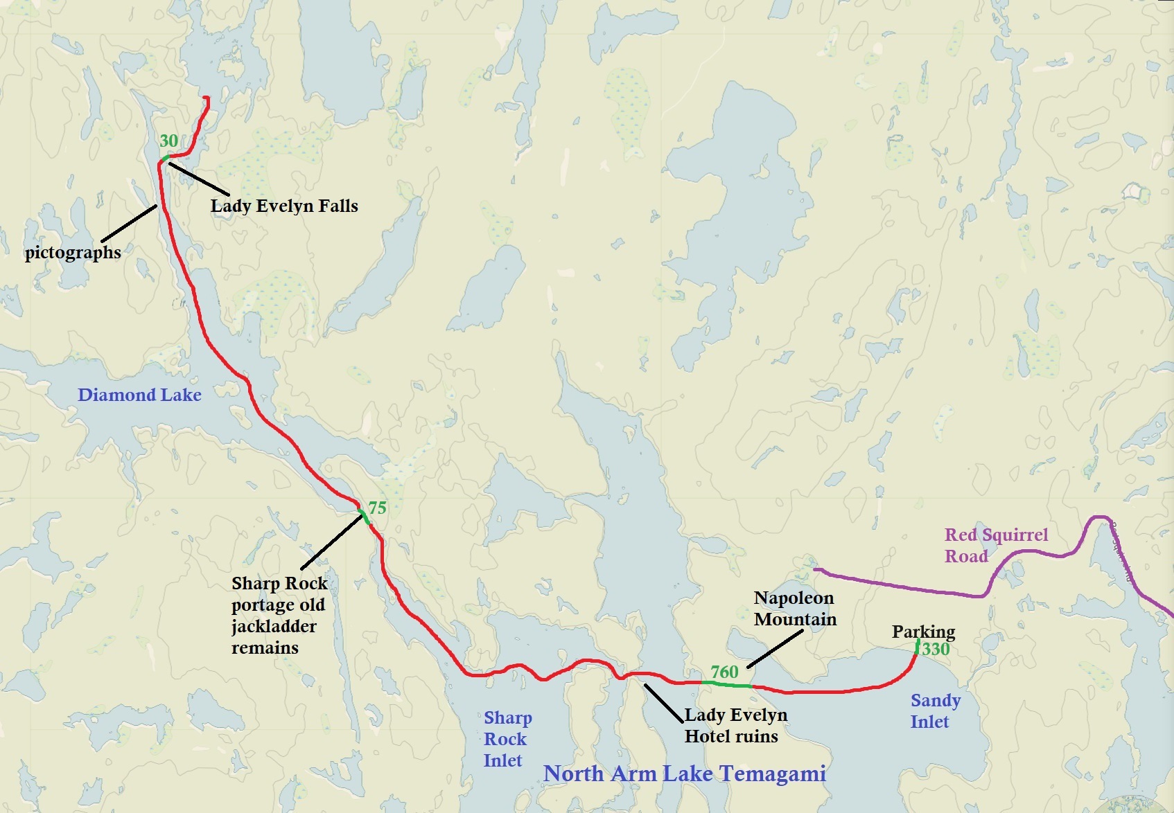
Route: Sandy Inlet (Lake Temagami) – North Arm (Lake Temagami) – Sharp Rock Inlet (Lake Temagami) – Diamond Lake – Lady Evelyn Lake – Willow Island Lake – Sucker Gut Lake – Willow Island Creek – Hobart Lake – Tupper Lake – Hobart Lake – Willow Island Creek – Sucker Gut Lake – Lady Evelyn River North Channel – Katherine Lake – Lady Evelyn River South Channel – Willow Island Lake – Lady Evelyn Lake – Diamond Lake – Lain Lake – Pencil Lake – Wakimika Lake – Wikimika River – Obabika Lake – Chee-skon Lake – Mud Lake – Bob Lake – Diamond Lake – Sharp Rock Inlet (Lake Temagami) – North Arm (Lake Temagami) – Sandy Inlet (Lake Temagami)
Maps Used: Chrismar Temagami 1 (Northeast), Chrismar Temagami 2 (Temagami). Jeff’s Map Temagami (Central). Ottertooth Maps (Sandy Lake Inlet, Sharp Rock Inlet).
Books Used: Temagami A Wilderness Paradise by Hap Wilson

On the Friday before our trip we drove up from the heart of southwestern Ontario, had a quick supper in North Bay, and arrived before 7pm at the Smoothwater Outfitters. At this highly recommended accommodation just off of highway 11 we spent the night in one of their smaller rooms. It was quaint, cozy, and just perfect for that one last shower before heading out into the bush.
DAY #1: Smoothwater Outfitters to Lady Evelyn Lake, Obabika River Provincial Park
Weather: Sunny with fog in the morning. High: 17 C Low: 3 C
The next morning was a chilly 3 degrees Celsius and very foggy! Driving south through the fog on highway 11 we turned down the Red Squirrel Road. For a forest road it was pretty decent with only a bit of washboard, along with some sections that have seen some recent washout. Driving through crownland we observed the occasional cleared patch of land. Usually located beside a body of water these cleared spots had trailers, trucks, 4 x 4s etc. These are crownland campsites, and if you are a Canadian citizen this means free camping! The only catch is you have to move 100 feet after every 21 days. We wonder if some people just trade sites back and forth throughout the summer so they can practically live there. The one drawback about camping right beside a forest road is the noise and dust from motorized vehicles driving past.
After driving for 28 kilometres we turned south to the “parking lots” to access the Sandy Bay Inlet access point. There are two areas of parking, and this section of what can only be vaguely described as a road is ROUGH! We parked in the first area, but not before dropping into a huge puddle that sent water rushing over the hood of the car! A few days prior to our arrival the area did receive a lot of rain, so we decided that it would be best to park the car and just portage to the second lot. We were so glad we did because the puddles after the area where we parked were ridiculously deep! Some even had car parts beside them! We did see a few cars, trucks, and SUVS parked along this section, and in the second lot, and we wondered if they arrived before all the rain as some of the smaller cars look like they would have a hell of a time getting out if they were leaving today.

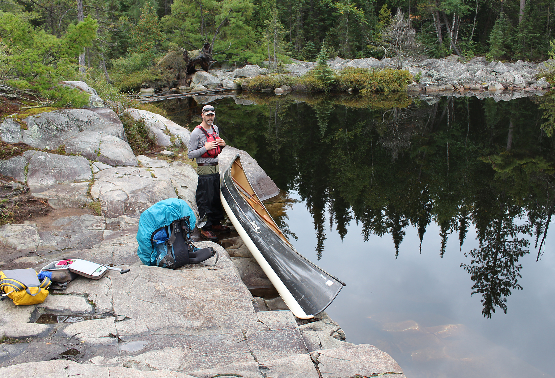
After the second lot is the 330 metre portage to Sandy Inlet at the very north end of Lake Temagami. It was an easy carry and greeting us at the end was a sandy beach with calm waters. This is always a welcome sign on the first day of any trip when our paddling muscles are still weak.
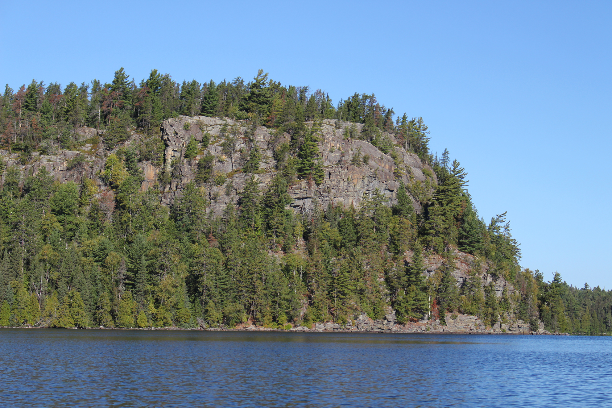
We paddled out onto the calm waters of Lake Temagami and before too long we heard the distant sound of a motorboat. It’s Saturday so a lot of people were enjoying what may be the last few nice weekends of fall. We had a nice leisurely paddle towards our first portage for the trip. Rising out of the water beside the portage is beautiful Napolean Mountain. No issues at the takeout though you do have to tilt your head back to get a view of the steep portage. After the initial climb, this 760 metre portage was your typical run of the mill well used portage with some rocky sections. At the put in we had a well deserved slug of water and some energy bars to snack on.
We now arrived in the North Arm of Lake Temagami. Lake Temagami is a huge lake, with a length of around 50 kilometres from north to south, and at 35 kilometres from east to west. Branching out in all directions it is a very odd shaped lake. You could easily have a week long (if not more!) canoe trip just exploring Lake Temagami, the perfect trip if you hate portaging!
As we continued to paddle on smooth water under beautiful sunny skies we observed a few more motorboats, along with our first sets of cottages. These cottages look similar to cottages you see in Algonquin, not those mansions you see in the Muskokas.
We decided to check out some local history as we paddled our way towards the remains of the Lady Evelyn Hotel. At three stories tall with close to a hundred beds, this was a pretty big operation between 1904 and 1912. It’s interesting to think that during this timed period there was up to three hotels on Lake Temagami. Arriving by steamboat you would arrive to your destination with all the comforts you would expect from a fine hotel. The unfortunate fate of the Lady Evelyn Hotel was that it was completely destroyed by fire. What remains today is a campsite on the immediate shore, perhaps the spot where former guests of the hotel would lounge at the lake. We pulled up on shore and walked back further behind the site where we found signs of plumbing, some bathtubs, and some metal bed frames among the trees.
Here is a link to a Wikipedia page that shows what the hotel used to look like: https://en.wikipedia.org/wiki/Lady_Evelyn_Hotel#/media/File:Lady_Evelyn_Hotel.jpg.


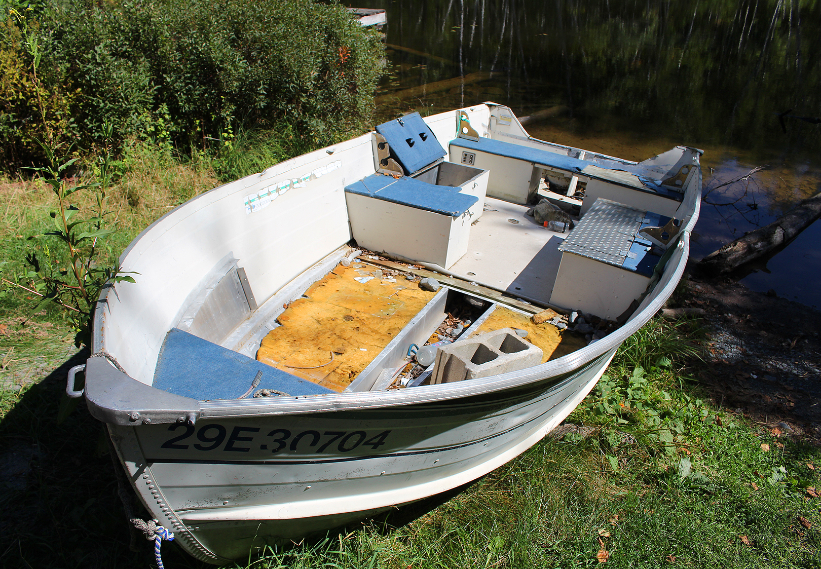
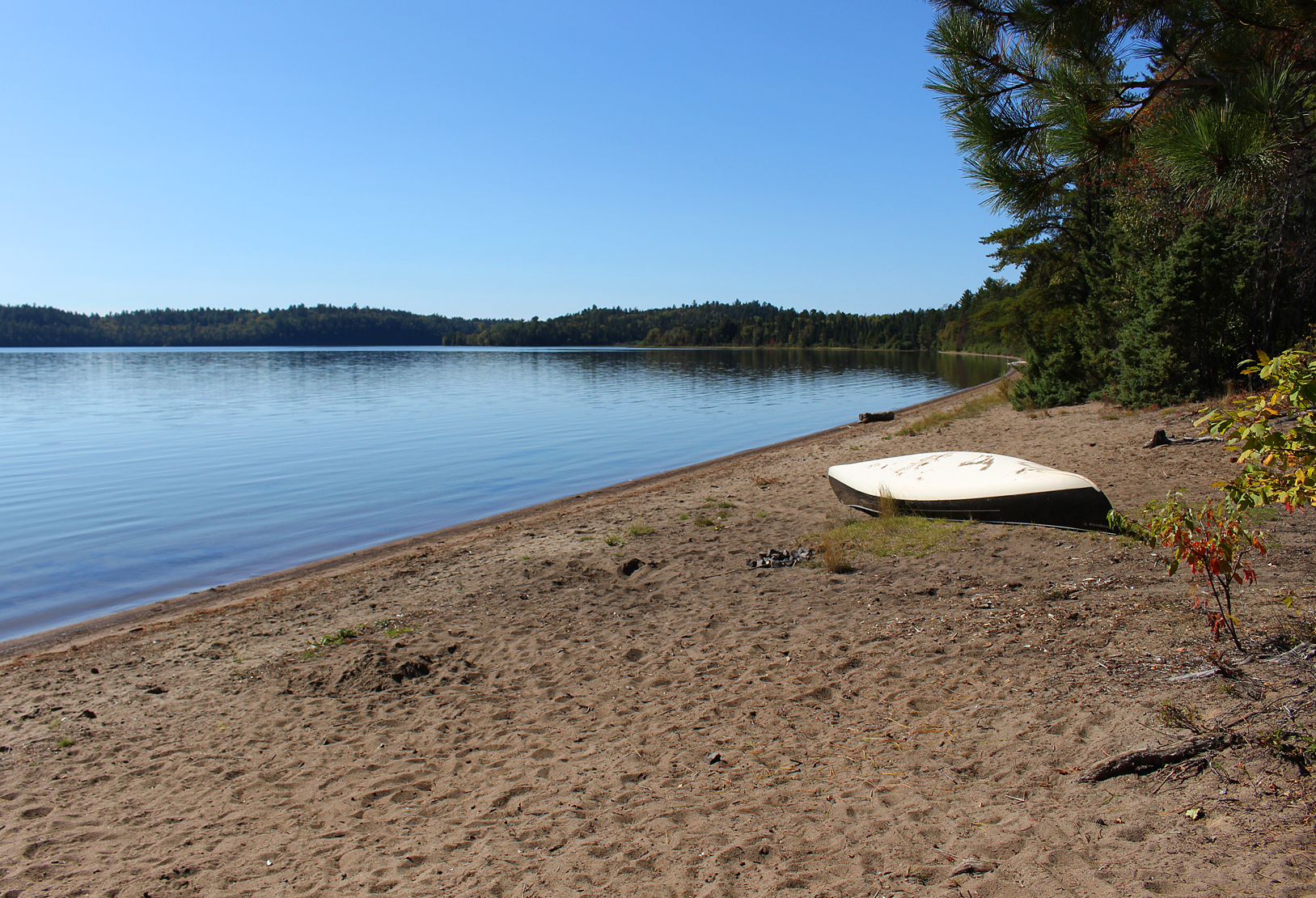
Continuing into the Upper Narrows of Lake Temagami we paddled our way into what is known as the Sharp Rock Inlet where we observed more cottages and motorboats. We soon arrived at the Sharp Rock Portage, and at the take out we saw a boat that has seen better days, now abandoned in the bush. The 75 metre portage goes over the Red Squirrel Road with a Provincial Park sign to greet you on the west side of the road.
We have now entered into Obabika River Provincial Park. Covering over 20,000 hectares, this classified waterway park was established in 1989, a time when tensions were running pretty hot between those staking claim to the Temagami wilderness. Obabika River Provincial Park protects some of the largest stands of old growth pine in the world, has many abandoned lumber camps to explore, and some of Ontario’s oldest known portages at over 5,000 years old.

The rest of the short portage had some rocks to negotiate around, and if you take some time to explore the area here you will find some faint signs of where there was once a Jack ladder. This would aid in lifting logs out of Diamond Lake into Lake Temagami during the 1940s and 1950s. In our haste to get to Diamond Lake we only observed a few remains on the ground. We will be coming back through this area on our way out so we will have another chance to explore more thoroughly.
The put in into Diamond Lake is rocky, and right at the shore we see a couple of tied up boats labelled with Ontario Parks stickers. On the stickers were written warnings that if the boats were not cleared out of there in one year they would become property of the crown! As we negotiated the rocks at the put in we met a group of canoeists that were just on their way out. We had a nice conversation and we learned that our routes were pretty much identical. Sounds like we have a great trip ahead of us!
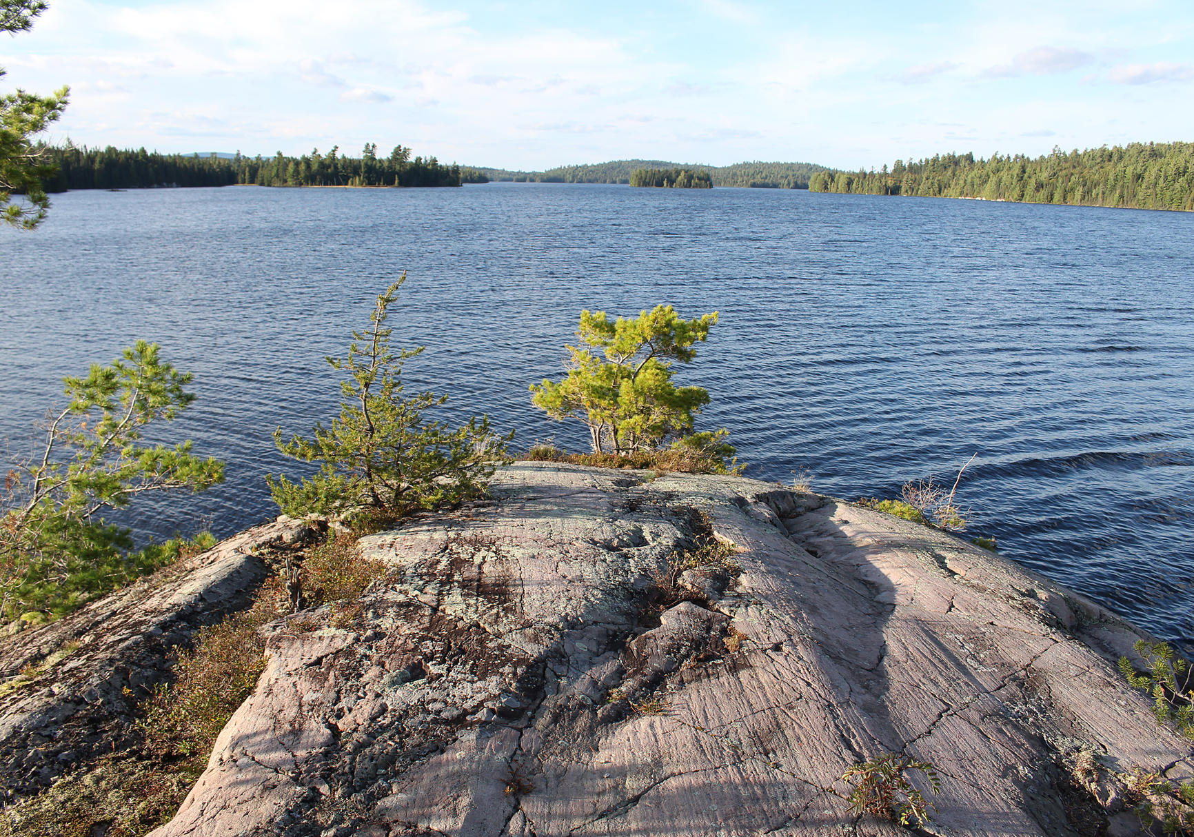
Heading west we now entered Diamond Lake, aptly named as it is quite the jewel of a lake with islands dotting its beautiful waters. Looking down at the map it appeared that every island has a campsite on it. We won’t be staying here tonight, instead we only have a brief paddle on Diamond Lake as we headed north towards our next portage.
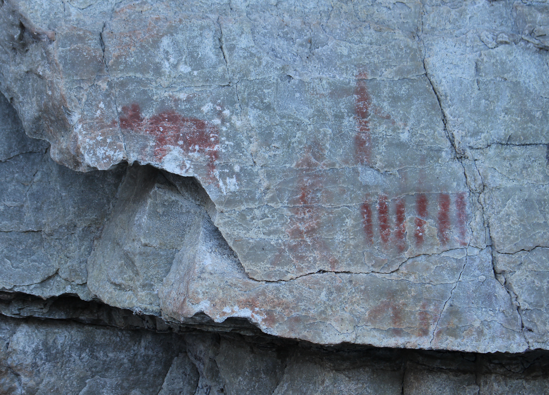
As the land narrows we paddled up to a rock face on the western shoreline that has a series of excellent pictographs. Some look similar to the images we have seen in Quetico including what appears to be people sitting in a canoe, a series of lines, and what may be a heron, or perhaps a goose. Other images look to be bird tracks, and what appears to be a moose. One image that seemed to be apparent is that of the Horned Snake, a creature (or perhaps a spirit) that appears on native rock art in other locations in North America.


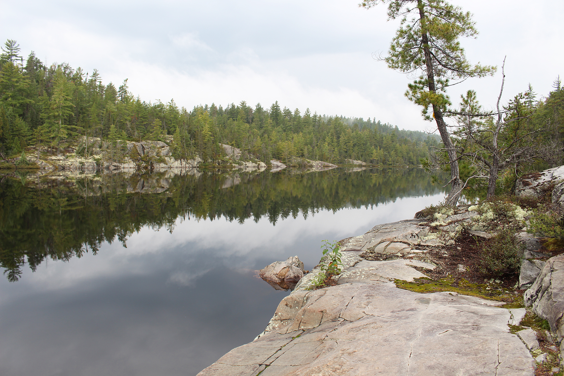
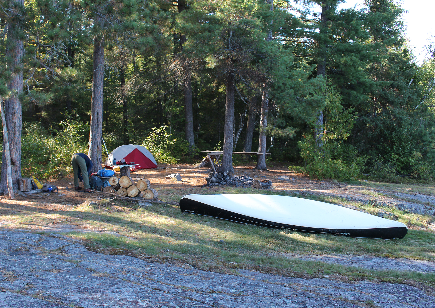
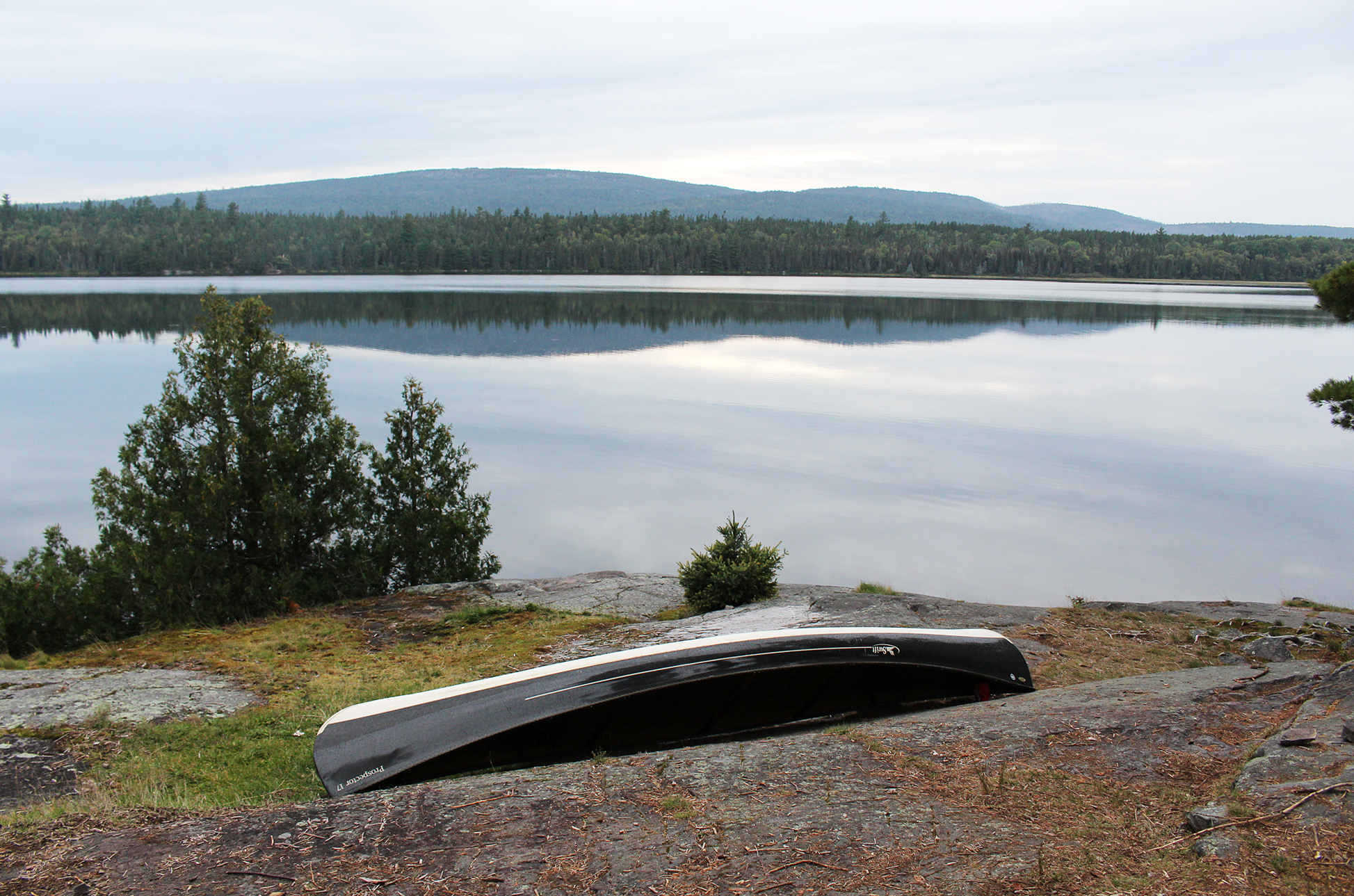
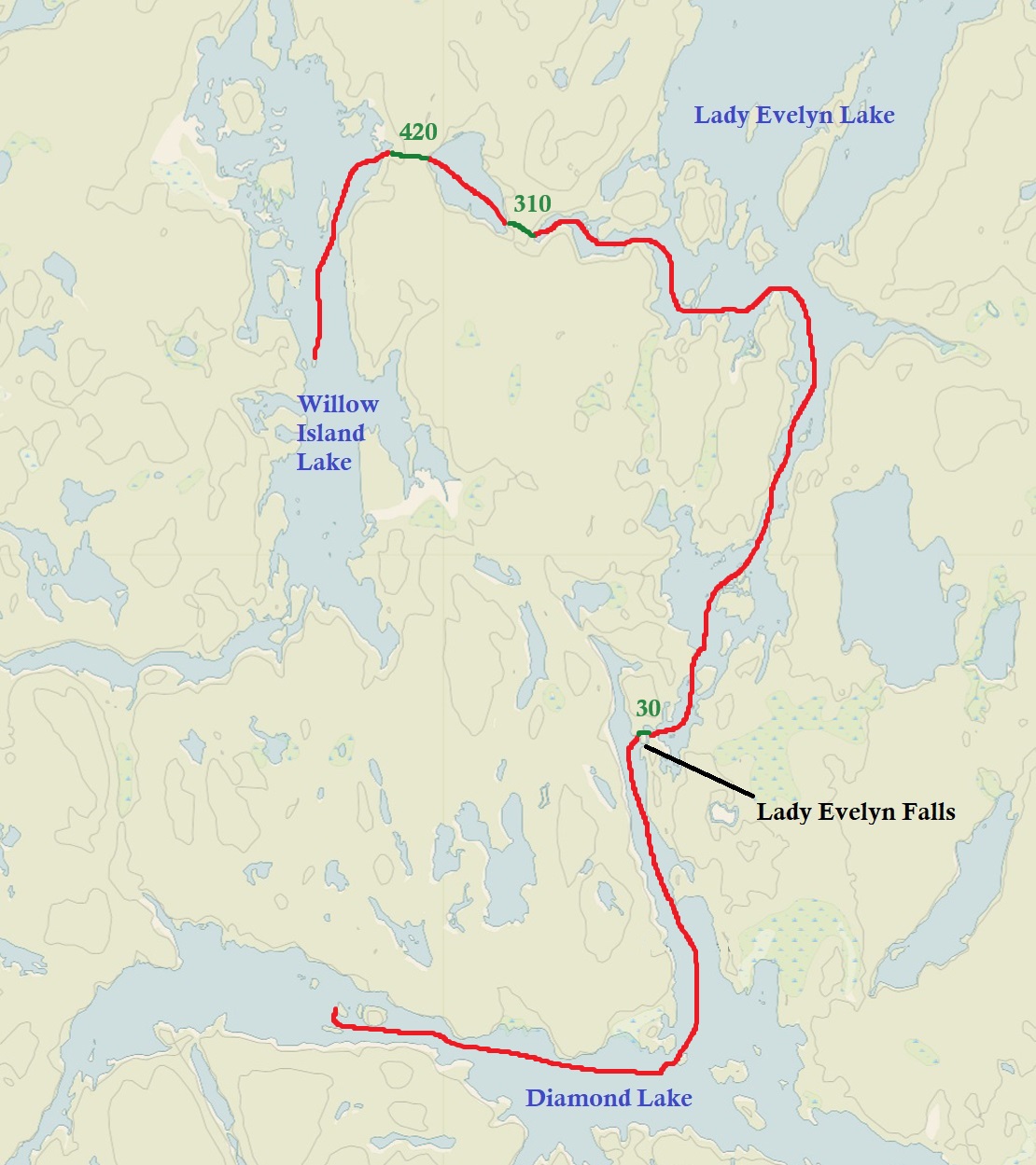
Just north of the pictographs we come to the short 30 metre portage at the small Lady Evelyn Falls where Diamond Lake and Lady Evelyn Lake meet. There is a campsite on the opposite side of the shoreline and we wave to a couple that are just setting up camp for the night. We should also be looking for a spot to set up camp as it was now approaching 4pm. After a brief paddle we came up to a nice big site on the western shoreline. This site had multiple flat spots for a tent, an easy put in/take out, and even a table and “chair”. Talk about luxury! Surprisingly the one thing we couldn’t find was a thunderbox, but this was just a minor setback. While Aaron had a nap, Marianne went on a quest to collect firewood for supper. Sheppard’s Pie over the fire was on tonight’s menu. A grill left behind by another camper is always a nice item to find at a site as it makes cooking over the fire easier. After supper we tidied up camp and relaxed by the fire.
We had a great first day in Temagami under sunny skies, and calm waters. Let’s hope the weather keeps this up!
Wildlife Sightings: Dragonfly sp., People, Raven, Common Loon, Red Squirrel, Common Merganser, American Toad, Ruffed Grouse, Golden-crowned Kinglet, American Pipit, Yellow-rumped Warbler, Small-mouthed Bass, Pileated Woodpecker, Belted Kingfisher, Mosquitoes, Leopard Frog, Canada Goose, Barred Owl
Remember to: Drill holes in our new canoe paddles to drain out the water when we get home. Check large puddles BEFORE we drive through them.
DAY #2: Lady Evelyn Lake to Hobart Lake (Obabika River Provincial Park to Lady Evelyn Smoothwater Provincial Park)
Weather: Sun with clouds during the day. Clouds by evening. High: 20 C Low: 6C

We crawled out of the tent just after 6:00am to get the fire going for a breakfast of oatmeal and our “Morale Tea” which is Twinning’s Irish Breakfast Tea. By 8:00am we were all packed up and ready for adventure except the fog, which was not even an issue until that moment, decided to do a big ‘ol belly flop and cover the entire area.
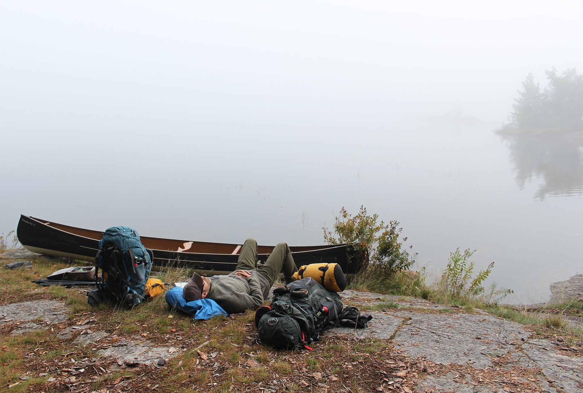
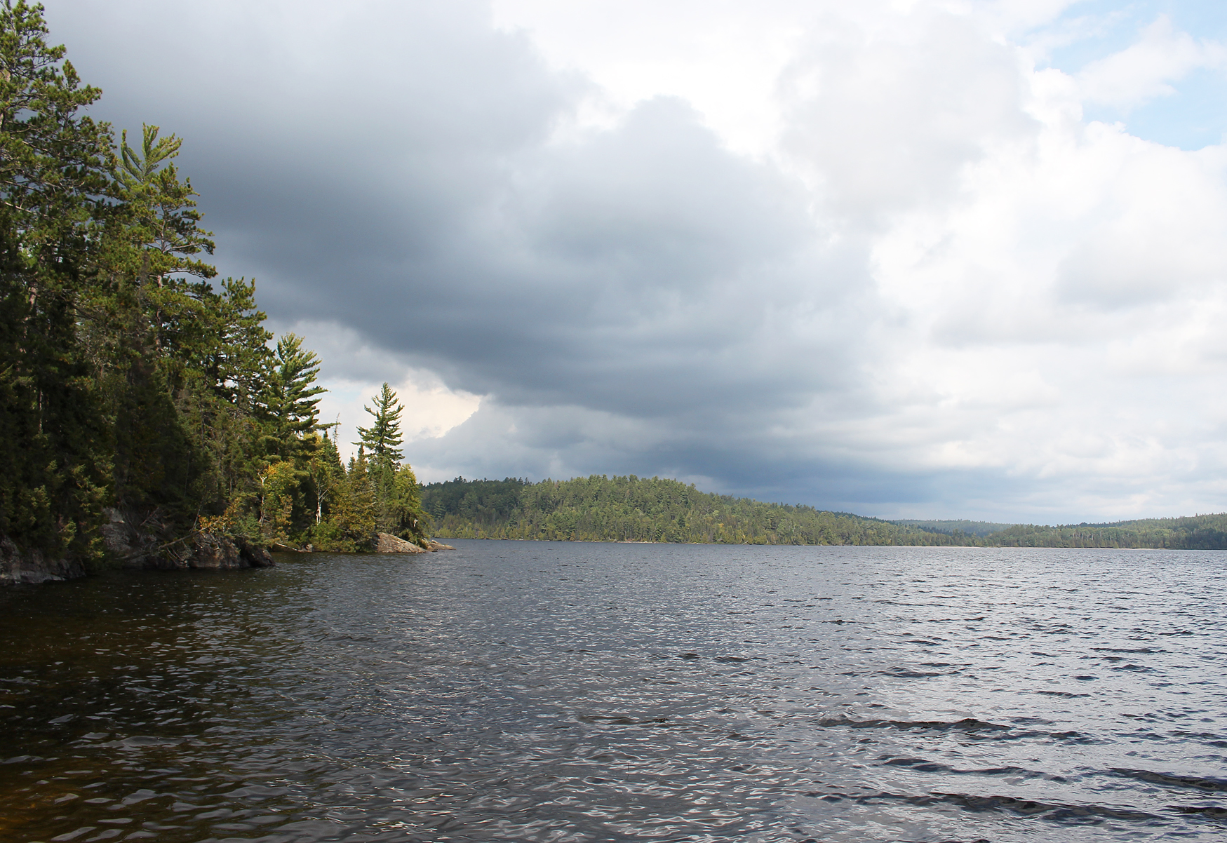
After a half hour of waiting we lost our patience and decided to get out the GPS. Before our trip we put our route in the GPS so Aaron had the brilliant idea to follow the line that was drawn to aid us through the fog. We entered into the thick fog and began paddling north at a snail’s pace since not only could we see nothing around us, but we also couldn’t see any rocks ahead of us. By the time we arrived to where the Lady Evelyn Lake widened the fog had almost all lifted. This was perfect timing because motorboats are allowed on this lake and in no time did we start observing those out enjoying the day. Lady Evelyn Lake is a pretty big lake. Notorious among paddlers for having big winds and waves, the possibility of getting wind bound should be on anyone’s itinerary if travelling though the wide expanse of this lake. Lucky for us it was a calm morning, and our route avoided the larger section of the lake as we made a sharp left, now heading towards our first two (and only) portages for the day.
The first portage at 310 metres was a little annoying at the beginning as there were some boulders over a stream. This was followed by a section where they rerouted the portage a bit to avoid some marshy sections. Along the stream Marianne scared a medium sized mammal, only capturing a glimpse of it as in ran up a slope into the woods. It looked to be a Fisher.

The next portage at 420 metres was a bit muddy but was definitely the easier portage between the two. Entering Willow Island Lake we paddled north and took a break for lunch at a campsite before entering Sucker Gut Lake. Lunch was a homemade creation of mac n’ cheese which consisted of egg noodles, powdered cheese, dehydrated broccoli, and a pack of tuna.
After sliding back into the water we continued to paddle north. Soon we caught a glimpse of the land rising to our west and viewed Maple Mountain, our destination for tomorrow. Probably another hour of paddling goes by when Aaron noticed something was a little bit….off.
Looking down at the map, the compass, and then looking around he soon stopped paddling. Marianne also noticed that he stopped paddling.
“What’s up?”
“This island shouldn’t be here”
After shaking the compass a few times the needle pointed north again. As for us, we discovered that we were heading southwest, pretty much the opposite direction of where we wanted to be, and with that about 3 kilometres off course! We wanted to go north/northwest, towards Hobart Lake. We righted ourselves and after almost an hour of back tracking we got back to where we wanted to be.
Paddling the northern section of Sucker Gut Lake is interesting. There are dead trees a fair distance offshore in the water that showed signs that they were burned at one point. Water levels used to be a lot lower here before the Madawaska dam was built to the northeast, and the charred trees are reminders of when the land was cleared. We soon entered a very narrow section of water before entering Hobart Lake. Here we met three canoes with six travelers, and as we entered into Hobart Lake we also met a couple in a canoe out for a paddle with no gear. Perhaps they took a day trip up to Maple Mountain.
We grabbed a large site on the east side of Hobart Lake. It is a heavily used site with multiple flat spots for a tent, though the takeout isn’t the most ideal as it is just a smooth rock, so probably slippery when wet. Wandering around the site we picked up garbage including two apple cores and a single self-serve oatmeal package. Marianne also has a weird tradition of always checking the thunderbox. This is not due to a weird fascination with how high the mountain of poop/toilet paper is, but to look and see if anyone dumped leftover food in it… yes this is a thing. Luckily the thunderbox was devoid of undigested food, though the apple cores thrown about was a bit concerning. We had a small fire tonight, mainly to burn the apple cores and a few other things left over in the fire pit. While collecting wood we scared a Garter Snake which quickly slithered its way into the undergrowth.

Common Loons are a regular site on any lake in northern Ontario, and as we had a quick supper of tea and energy bars by the fire we watched a parent Loon still feeding its clingy offspring. The young loon, donning a brown and white plumage was almost the same size as Momma/Dadda Loon.
Clear in the distance from our site is Maple Mountain, our destination for tomorrow. We hope it doesn’t rain!


Wildlife sightings: Barred Owl, Red Squirrel, Sandhill Crane, American Pipit, Pine Siskins, Red-breasted Nuthatch, American Robin, White-throated Sparrow, Yellow-rumped Warbler, Pileated Woodpecker, Red Crossbill, People, Common Loon, American Toad, Northern Flicker, Bass sp, Hairy Woodpecker, Fisher, floatplane, Garter Snake.
Remember to: No remember to today!
DAY # 3: Maple Mountain (Lady Evelyn Smoothwater Provincial Park)
Weather: Cloudy with light drizzle in the morning and the evening. High: 17 C Low: 13C

No fog this morning, but instead we were greeted with clouds and very light sprinkles of rain as we got out of the tent. Luckily the rain held off for breakfast. While Aaron pumped water, Marianne flipped over the punky log in the fire pit, added some dry twigs, and with a single flick of the lighter it was go time! After getting some coals going it was time for our favourite breakfast, a pancake topped with melted peanut butter and jam 🙂

More sprinkles of rain returned when we began the paddle towards Tupper Lake, with only one quick lift over a beaver dam. Tupper Lake was quite the marshy looking lake, especially as you near its northern and western shores. Located on the eastern, less marshy side of Tupper Lake are two campsites. Both sites were vacant as we paddled by, and from the view of a canoe they didn’t look particularly inviting.
The take out for the hike up Maple Mountain was really muddy, and we avoided the mud by stepping where others have trampled down the long grass. Hiding the canoe out of site and well out of the way, we grabbed our day pack to begin our hike, but not without first checking out the relics of the fire ranger’s cabin. All that remains today is some structure and the frame of a bunk bed.

A 4.3 kilometre hike with a 351 metre elevation change, the hike up Maple Mountain was one of the most challenging mountain climbs with have ever done in Ontario. It is definitely more challenging than Ishpatina Ridge, the highest peak in Ontario, which is also located in Temagami. What makes Maple Mountain the more strenuous between the two is that it has more of a vertical rise. In fact Maple Mountain ranks number 1 in vertical rise in Ontario. As for height it is 17th highest in the province.
The hike up Maple Mountain begins easy enough as it is relatively flat with a section of makeshift boardwalks to avoid getting a soaker if the surrounding bog has high water. After you get about halfway up the mountain there are some pretty steep sections, and after Halfway Lake it gets ever steeper, and we found ourselves taking frequent breaks. At last we arrived right up against a rock face, and we could tell we were almost to the top with only a couple more obstacles in our way. The first of those being the Hillary Step. This is the name of a “ladder” though it is only made up of 1 inch gas pipe with EMT in between. The ladder is not attached to the cliff, only leaning up against this steep incline and crooked at that. No turning back now!

Marianne went first (don’t turn around and look down!), and Aaron came up behind with the pack. At the top of the ladder you have one more obstacle in that you have to shuffle your body to a small stable patch of rock, followed by a brief walk along the edge of the cliff (do not slip or you’re in trouble) before you finally make it to the top on more stable ground. From here we soon caught a glimpse of the 100 foot fire tower and made our way towards it. This fire tower is in better shape than the one on top of Ishpatina Ridge in that it isn’t showing signs of crumbling at any of its four bases. Just like the tower at Ishpatina the bottom rung of the ladder has been removed, and there is a sign that says to not climb the tower.

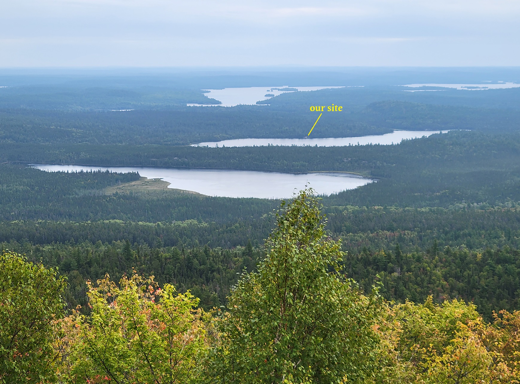
The view at the top of Maple Mountain is an excellent one! Looking east we can easily see Tupper Lake, Hobart Lake (including our site!) and Sucker Gut Lake. The great view is thanks to the fire ranger’s kids playing with matches and burning the top of the mountain. Thank you! 🙂
To the west we weren’t sure what lakes we were looking at as we didn’t bring a map covering that area. Way far off in the distance there are some rolling hills and we wondered if one of those is in fact Ishpatina Ridge as it is only a mere 32 kilometres from where we were. While on the mountain we got out Marianne’s cellphone as we can actually get a signal from way up here. We texted her Mom, her friend Jeremy, and got the weather report. Looks like we are in for a lot of rain tomorrow!
We had a prepackaged freeze dried lunch at the base of the tower and gave ourselves a chance to dry off as we were quite sweaty from the climb. A flock of Canada Geese flew by, almost at eye level which was an odd sight as they were migrating at their normal height. We even had a couple of Red Crossbills land at the base of the tower. Oh to be a bird! They make it look so easy!

The hike up Maple Mountain took around 1 hour and 45 minutes. Of course going down was a lot quicker, though going down that ladder was a lot harder than going up it! We were very fortunate that it didn’t rain during the whole time we were hiking up the mountain, or the paddle out. As we paddled back to Hobart Lake we met four guys in two canoes that were just on their way to hike to the top. They grabbed the site just to the north of ours on Hobert Lake.

We put up Magitarp (yes, we named our tarp) when we got back to our site as the forecast called for rain. We also made the decision to use tomorrow as one of our layover days, not just for the weather but because our bodies need a day to recoup from that hike. While Aaron took a nap, Marianne collected wood for tonight’s fire. Tonight’s menu is chili over the fire. We soon realized that we forgot our chili powder, and instead we added some dehydrated black bean hummus which was just as good. Momma (or Dadda) Loon, along with clingy teenage Loon were back again this evening as we sat at the shore pumping water for tomorrow.
Our new neighbours returned from Maple Mountain at around 7pm, and we could hear them enjoying the evening as we settled in for the night in our snug sleeping bags, the sound of light rain hitting the tarp.
Wildlife Sightings: Common Loon, Merlin, Spruce Grouse, Pine Siskins, Red Crossbill, Great Blue Heron, People, American Pipit, Canada Goose, White-throated Sparrow, Red Squirrel, Red-breasted Nuthatch, People, Black-capped Chickadee, Mallard.
Remember to: Check each ingredient for our meals before we pack.
DAY #4: Hobart Lake (Lady Evelyn Smoothwater Provincial Park)
Weather: Light rain on and off during the day. Slight breeze in the evening. High: 12 C Low: 12C
Despite the light rain hitting the tarp, along with the sound of small mammals scurrying and chattering around the tent, we had a really good sleep last night! We slept in until 8:00am as we listened to the continuing sound of light rain. Breakfast was cold cereal and hot tea which we enjoyed under Magitarp and vestibule. By mid morning the rain stopped for a bit, and we waved to our neighbours as they paddled past our site making their way out of Hobart Lake.

Though it was cooler today there wasn’t much of a breeze, and by noon it was clear that we were definitely NOT getting all the rain that was forecasted. In fact, Environment Canada had our region under a rainfall warning, and you know you can always count on Environment Canada for the most accurate forecasts….That was typed sarcasm. 😦
For the most part the day consisted of overcast skies with the occasional misty rain. Through the clouds and mist we would once in a while catch a glimpse of the top of Maple Mountain and the fire tower. Known as Chee-bay-jing to the Anishnabe people, Maple Mountain is a sacred site to them. In the 1970s there were talks to turn Maple Mountain into a ski resort complete with hotels and everything! Luckily this never came to pass, and with the creation of Lady Evelyn Smoothwater Provincial Park Chee-bay-jing, the “Ghost Mountain” remains the sacred ancient burial site of the Temagami first people.

We took a chance in trying to have a fire tonight. This involved taking a long walk in search of some wood as most of the area surrounding the site had been picked clean. Though this is not a “rule” it is a good idea to not collect wood right beside your campsite as this keeps the site in more of a natural state. A common practice that we notice in all areas we camp is the cutting down of greenwood. Not only is this frowned upon, but it doesn’t even burn! We salvaged enough wood to get another fire going, and luckily the rain stayed away so as to get some hot coals going to make some Bannock. Of course, we had to add some parmesan cheese on top to make it taste something like Little Cesar’s Crazy Bread!

The rest of the late afternoon involved getting our stuff in a pile because tomorrow we are leaving rain or shine! Our plan is to get to the North Channel of the Lady Evelyn River, and how wet the rocks are along that section of portages will dictate how far we get tomorrow.
Wildlife Sightings: Common Loon, People, Northern Raven, Black-capped Chickadee, Mallard, Red Squirrel, American Toad, Pine Siskin, American Pipit, American Crow, People
Remember to: Melt the ends of our cut rope. Add a little more salt to the bannock powder.
DAY 5#: Hobart Lake to Helen Falls (Lady Evelyn Smoothwater Provincial Park)
Weather: Cloudy with mist in the morning and into the afternoon. High: 10 C Low: 10C

Hot breakfast cereal with a pot of morale tea under the vestibule was the order for breakfast this morning under a sky of misting rain. Donning our rain gear we left our site just before 9:00am. Paddling into Sucker Gut Lake we observed a solo paddler in a canoe, while heading south on Sucker Gut Lake we noticed someone at the island site. It was only around 10:30 am when we got to Frank Falls and the beginning (or rather end) of the North Lady Evelyn River. We originally thought that this was going to be as far as we got today, but with no rain and dry rocks we decided to go for it.

Frank Falls was the first set of falls we would see over the course of the next few days. The takeout here is not too difficult, and the 120 metre portage was just over a series of dry rocks around the falls.
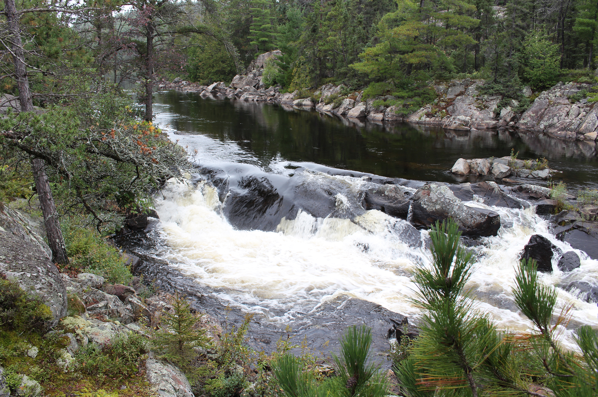
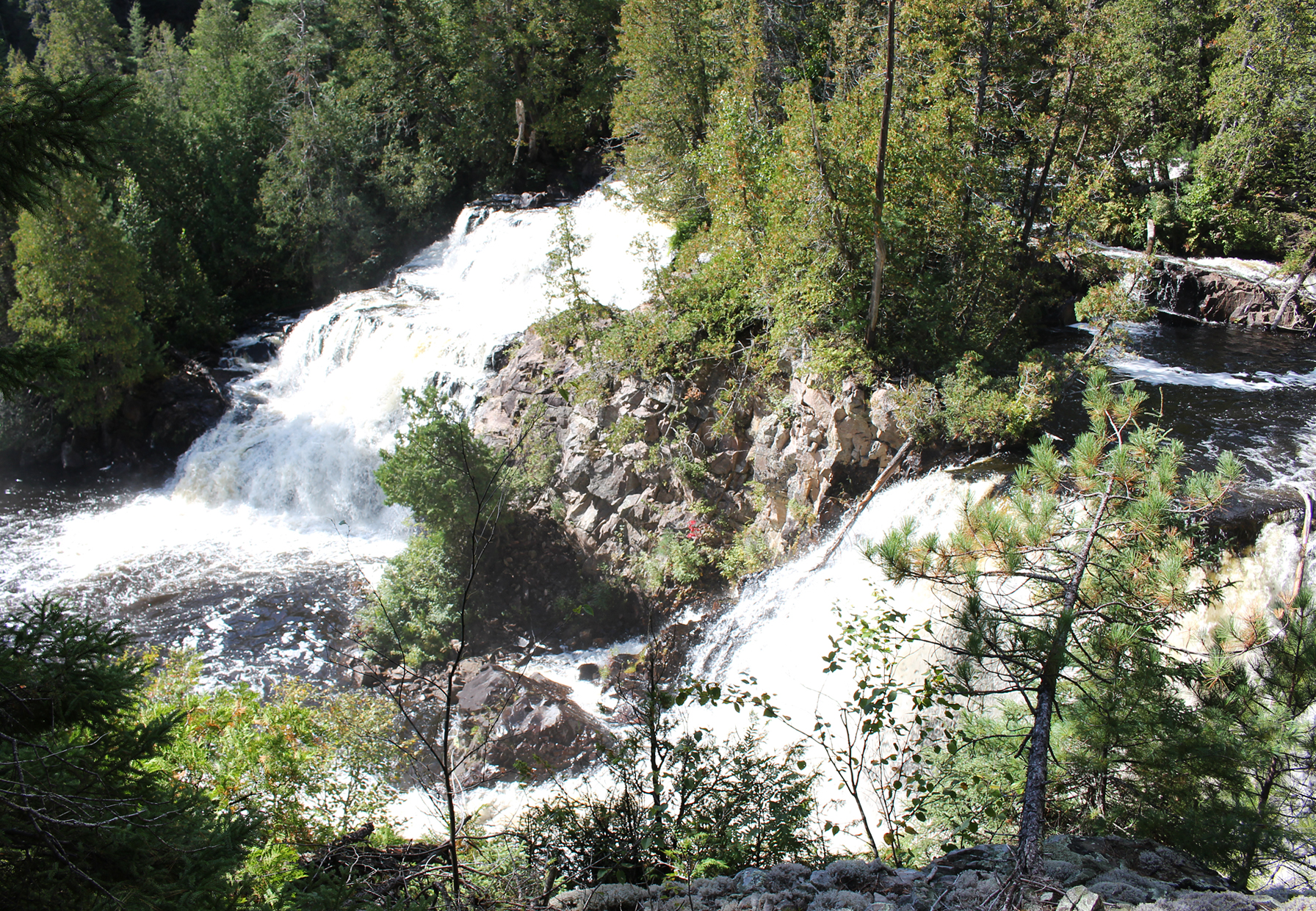
After a short paddle it wasn’t long before we heard the distant roar of the next set of falls known as Centre Falls. At 420 metres, the portage around the falls starts out easy enough up to the point where there is a campsite along the portage. Having a site right beside the falls is fantastic, but the sound of the roaring falls is so loud we almost have to yell to talk to each other. We also wonder if one could even sleep at night? In the end it was the time of day that made the decision for us as it was only noon, so we took a few photos and continued on.

It is right after this site that the portage got a little weird. It looked like park staff created a new portage to go around a very steep incline, which perhaps may have been the so-called “golden staircase” we heard about? This new section, though possibly easier than the original, was a bit tricky for us as it was not worn down yet, making for some tricky footwork. The put in was a little rocky, including some rocks that were wet and slick. After another brief paddle we had to get out on the rocks yet again to get around some rapids by taking a 170 metre portage.
It started to mist rain when we approached the take out for the 340 metre portage around Helen Falls, and we were beginning to feel slightly chilled as we no longer had our rain gear on. Though it sounds silly, sometimes it is better to be slightly chilled from the air than to be soaked in sweat from rain gear that doesn’t breathe, especially when the air is cool. Nothing is worse than being cold and damp to the bone from wet skin!
Marianne checked out a site right before the portage, but it didn’t offer much in the way of shelter, nor a flat spot for a tent, so we decided to attempt the portage.

The beginning of the portage consists of a climb up a hill and soon we came to a site right along the portage. It was close to 3pm now and with the misting rain we decided that this would be our home for the night. Marianne did take the time to walk ahead along the portage to check it out. There were large slippery rocks in the next section, so we were thankful that this site exists!
We quickly set up the tent and went inside to get out of the cold and mist to warm up. Being so damp outside we spent the rest of the afternoon inside the tent and played cards. Supper was a light affair of just GORP and some bars. We only had enough water for brushing our teeth along with a spot of tea for tomorrow morning as neither of us felt like climbing back down the slippery hill to pump water at the lake.
All cozy in the tent tonight we listened to the distant sound of the falls farther down the portage. This is a nice white noise to fall asleep with, instead of the near absolute silence of fall when even the bugs no longer sing at night.
Wildlife Sightings: Common Loon, American Pipit, Northern Raven, Broad-winged Hawk, People, Black-capped Chickadee, Red Squirrel, People.
Remember to: No remember to today! Yeah!
DAY #6: Helen Falls to Katherine Lake (Lady Evelyn Smoothwater Provincial Park)
Weather: Sunny with sun and clouds and a slight breeze in the afternoon. Clearing and calm by evening. High: 16C Low: 8C

The site along the portage where we spent last night is not well used, and with the area being overgrown and damp it shouldn’t have been a surprise to either of us that there were two slugs crawling up the side of our tent this morning. After a quick breakfast of tea and bars we packed up to continue along the portage, but not before knocking one more slug off one of our packs. There were still some sections along the portage that consisted of damp rocks, but not as bad as it was yesterday.

The put in was an easy one which is nice after such a rocky portage, and before we knew it we were in the canoe again, and then out of the canoe again to portage around some more rapids. At 270 metres the takeout here was quite precarious as it was just a bunch of boulders. Luckily, the day before Aaron tied the rope to the canoe. While Marianne held onto the rope, Aaron grabbed our gear and leapt from rock to rock with all the grace of a Mountain Goat, while Marianne hobbled along like a drunken giraffe. Though this take out may have been one of the most difficult of the entire trip, the put in was easy-peesy and flat!

Back in the north channel of the Lady Evelyn River we had just enough time to shift the packs to stabilize the canoe when it was time to get out yet again for another portage around a series of rapids. At a short 170 metres this portage wasn’t bad at all, that is until the boulder field in the middle of it which required some tricky footwork. The put in was very nice, as was the campsite at the end of the portage at Katherine Lake. There was a nice flat spot for a tent, a nice spot to bath, and a descent firepit! Though it was only 11 am in the morning we couldn’t pass up such a nice site after last night’s damp scruffy portage site! It was sunny, the temperature was nice, and with a damp tent and towels to dry out we hung up a clothesline, and pumped water for lunch. Lunch consisted of spaghetti and a drink of blue Gatorade. While relaxing along the shoreline we noticed a canoe at the opposite shore heading down the South Channel of the Lady Evelyn River. Its occupants were two adults and what we assumed was a kid….or a dog.

After lunch we decided to bathe. The water was cold, and of course the breeze decided to pick up during this time, but man you feel great afterwards! The rest of the day involved just chilling at our site. While Aaron had another afternoon nap, Marianne kept herself busy by looking over maps, and gathered some wood for tonight’s fire. While we were at the shoreline pumping water for supper we heard something coming down the portage. It was a Swift Kewatin canoe with a guy underneath it carrying a kayak paddle. It was the same soloist we saw the other day while at Sucker Gut Lake. We had a nice conversation and we found out that he also hiked Maple Mountain, and like us was going down the Lady Evelyn River tomorrow.

When the breeze died down this evening a few blackflies showed up just in time for supper. Lucky for us they were just annoying and not biting. As soon as we made a smoky fire they buggered off. Just a nice hot meal of chicken noodle soup tonight as the cool night air quickly arrived after the sun went down.

Wildlife sightings: Northern Raven, Blue Jay, American Pipits, People, Red Squirrel, Bald Eagle
Remember to: Bulk Barn minestrone soup base is better than their chicken noodle soup base, HOWEVER it needs more noodles, along with less soup mix to water ratio to make it not as salty.
DAY #7: Katherine Lake to Willow Island Lake (Obabika River Provincial Park)
Weather: A mix of sun and clouds. Slight breeze in the afternoon. High: 18C Low: 4 C

We got up at 5:30 am hoping to get an early start on the Lady Evelyn River, but somehow we didn’t get on the water until 8:45 am. We have a total of eight portages today and though they are short, a couple of them have a reputation of being very challenging as well as treacherous.
All we had to do was launch from our site and go around a point of land before getting out of the canoe for our first portage for the day, a 200 metre around some rapids. The highlight was a very tame Spruce Grouse (and of course no camera at the ready). We went first with our packs down the portage, and we could see we were in for a tricky put in at the end as it was just a pile of rocks along the river. While going back for the canoe we met the solo paddler at the takeout. Returning back to the put in with the canoe we ended up getting stuck on a rock when we both got in and had to shimmy back and forth to get the canoe into the river. Take outs and put ins varied in level of difficulty along this section of the Lady Evelyn River, and though constantly getting in and out of the canoe with our gear along a river can be a minor pain in the butt, the view of these northern falls was well worth it!
After another portage around some rapids we reached the take out to Cabin Falls, also known as Twin Falls. While getting our packs out of the canoe the legend himself, Hap Wilson, along with his wife Andrea showed up from their ecolodge at Cabin Falls.

An insert in this trip report regarding what Hap and Andrea have done for conservation, among other achievements would be more than just a segue but a separate post in itself. Instead, here is a link to Hap’s website:
The portage along Cabin Falls wasn’t bad except for the last section where there was some awkward foot work around roots and rocks.
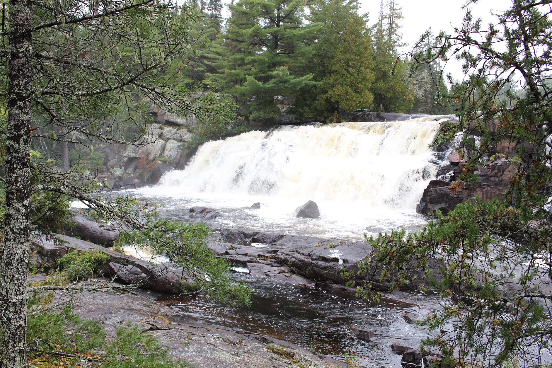
After another brief paddle we soon made it to the 220 metre portage around Bridal Veil falls, arguably the most impressive falls along the Lady Evelyn River. At the beginning of the portage we met a couple, their young son, along with their small dog. They were the same group we viewed the day before in a canoe from our site on Katherine Lake. After salutations we learned that they got flown into Florence Lake (we observed a low flying floatplane a couple of days ago) and were making their way towards Lake Temagami. It’s so awesome to see young kids out here in the wilderness instead of being glued to their devices!
The falls along this section of portage were just spectacular! Overall the portage was not that challenging, that is until we came up to what may have been the most precarious section of portage we have ever come up against! Towards the end after the falls there is a rockface with a sheer drop down to the river that luckily also has some shallow rocks along the shoreline. You have two options here. Option #1 is to walk almost tight rope like on a stick that was placed out at the top of the rockface. It was maybe 15 feet in length from what we can remember, and we did manage to cross it with just our packs. Aaron did it no problem on two feet, but Marianne, knowing that one slip would mean falling around 12 feet to either broken bones or possible death, went on all fours. As for the 17 foot canoe there was no way we were going to attempt this! This led us to Option #2. Both ourselves, and our portage companions that later met up with us, decided to drop the canoes via a rope down the neighbouring slope to the river. After this you would proceed by going along the rocks hugging the shore and soon connect back to the portage and to the put in.

We were glad when this was all over and we got ready to get back into the river and on our way. Of course we had to have one last look at the beautiful roaring falls behind us as we slowly made our way with the current.

We had a little bit of a paddle now, and we observed some interesting geographical features right after leaving Bridal Veil Falls in the form of some loose gravel along the river bank. Good thing we don’t have to portage up it!

As noon approached we arrived at the longest portage of the day at 670 metres around a series of rapids. Albeit a boulder garden at the beginning of the portage it was easy going, feeling more like a well-used Algonquin Provincial Park portage. In fact, this was probably the easiest portage of the whole day! As we arrived back in the river it was a quick and smooth paddle up to the takeout at Fat Man’s chutes. We pulled the canoe ashore and found a nice flat spot to have lunch. There is a small fire pit here, and a flat spot for a tent if one wanted to camp here.

Fat Man’s portage wasn’t too difficult, and we chose to go around the “Fat Man’s Squeeze”, a cut in the rock just wide enough to fit an average canoe. The put in at the end of this portage was ridiculous to put it mildly. It was steep, made up of some large (and sometimes loose) piles of rock, and there was no good spot to even put the canoe into the river. We had to tip the canoe on a 60 degree angle while using the aids of ropes to lower it down to the river. After getting it stable in the water we had to gently toss our gear, and later ourselves in which went better than expected. It was nice to get that one over with!

After a couple small portages around some rapids it was time to take our boots off and put on our close toed sandals. For one reason or another there is a section of rapids at around 100 metres in length that actually does not have a portage. Your option is to either run or line the canoe instead. Looking at the rapids there was no way we were going to run our carbon fibre canoe! We are no experts in the art of lining a canoe, and though we did a decent job on last year’s trip in shallow water, the river this time was wide and a lot faster! Walking along the shoreline was a bit of a challenge as we waded in what was at first ankle deep, and later almost knee deep water, all the while carefully moving our feet between rocks that you couldn’t really see due to the fast moving current. We took it slow, each of us holding a rope and giving a lot of slack for the canoe to bob in the water while not losing control of it. Eventually the rapids calmed down and the water got deep enough so we could get back into the canoe again. According to the map there was supposed to be one last portage after this, but we completely missed it (if it was even there?), and instead we ran some swifts with no issues. We gave a sigh of relief as we were now done the series of portages, rapids, and waterfalls along the Lady Evelyn River.
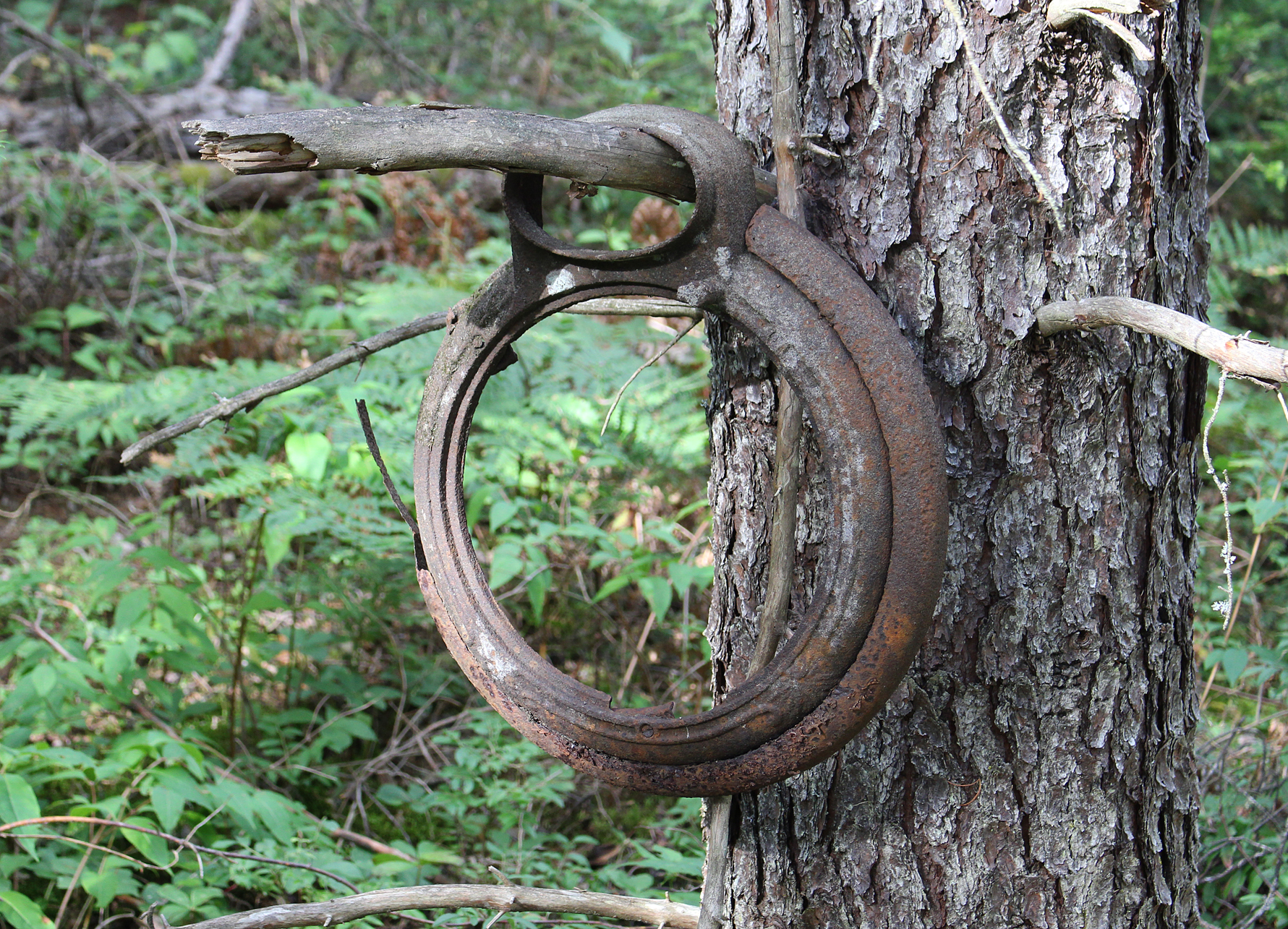
On the right side of the river we pulled onto shore where there was a camp site to dry off our feet and put our hiking boots back on. This was a pretty poor campsite but we had no intention of staying here. It was time to go explore as there were supposed to be remnants of a logging camp here. It wasn’t too long before we saw the remains of the old Depot Lumber Camp that was used in the 1950s. Here were some remains of some sort of building, along with some other items, but the highlight was an old truck! Curiously the steering wheel was on the right side.


Back in the canoe the Lady Evelyn River continued to widen, and as it did it no longer felt like a river as it emptied into Willow Island Lake. It was nice to be on big water again, and what was even better was that we had a tailwind!! Whoot!!! After checking out a site on the eastern shore that didn’t tickle our fancy we turned and paddled west, settling on the island campsite in the middle of the lake. The site had an okay take out, and a flat spot for a tent. What was lacking was a seating area around what was a pretty poor firepit. It didn’t matter though as it was just after 5:00pm and we were just glad to be off the water. The north end of the island consisted of a nice flat rock with a beautiful glacial groove to just lay back and relax on. From this vantage point on the island there was a nice view of the lake and surrounding land with Maple Mountain just barely visible in the northwest. With the aid of binoculars we could even see the fire tower. After a supper of Backpackers Pantry Pad Thai and a fresh apple from home, we stretched out on our backs on the flat rock and stared up at the sky. One by one the stars began to twinkle after the sun set behind the forested hills. Aaron even observed something similar to a shooting star, but it was fiery red instead of the usual white so maybe a meteor?
Today was both challenging and very rewarding for us with perhaps the most technical portages we have ever traversed, and some of the most scenic, rugged falls we have ever encountered in Ontario! Tomorrow should be an easier day as we would begin to back track through the now familiar Lady Evelyn Lake on our way back to Diamond Lake.
Wildlife Sightings: Red Squirrel, Raven, People, American Black Duck, American Pipit, White-throated Sparrow, Pileated Woodpecker, Red Crossbill, Pine Siskins, Blue Jay, Spruce Grouse.
Remember to: No remember to today! Ya!!!
DAY #8: Willow Island Lake to Diamond Lake (Obabika River Provincial Park)
Weather: A mix of sun and clouds. Windy by the afternoon. High: 20C Low: 13C
You would think that after such a long day of portaging we would have slept in a bit, but instead we were up in the predawn hour at 5:30 am. After some cold pumpkin flax cereal and a spot of “Morale Tea”, we were back on the water again by 7:50 am, paddling our way north on beautiful Willow Island Lake. We were now doing a bit of back tracking, heading into Lady Evelyn Lake via the two portages we travelled almost a week ago, as we would make our way back to Diamond Lake for the night.
Today was also our very first day of experiencing head winds which was just unfreakinbelievable because it seems like EVERY trip we have ever been on involved multiple days of headwinds! It was on Lady Evelyn Lake where we encountered them, and we were fortunate to be at the smaller south end of the lake as we probably would have been wind bound if we were in the larger section of it.
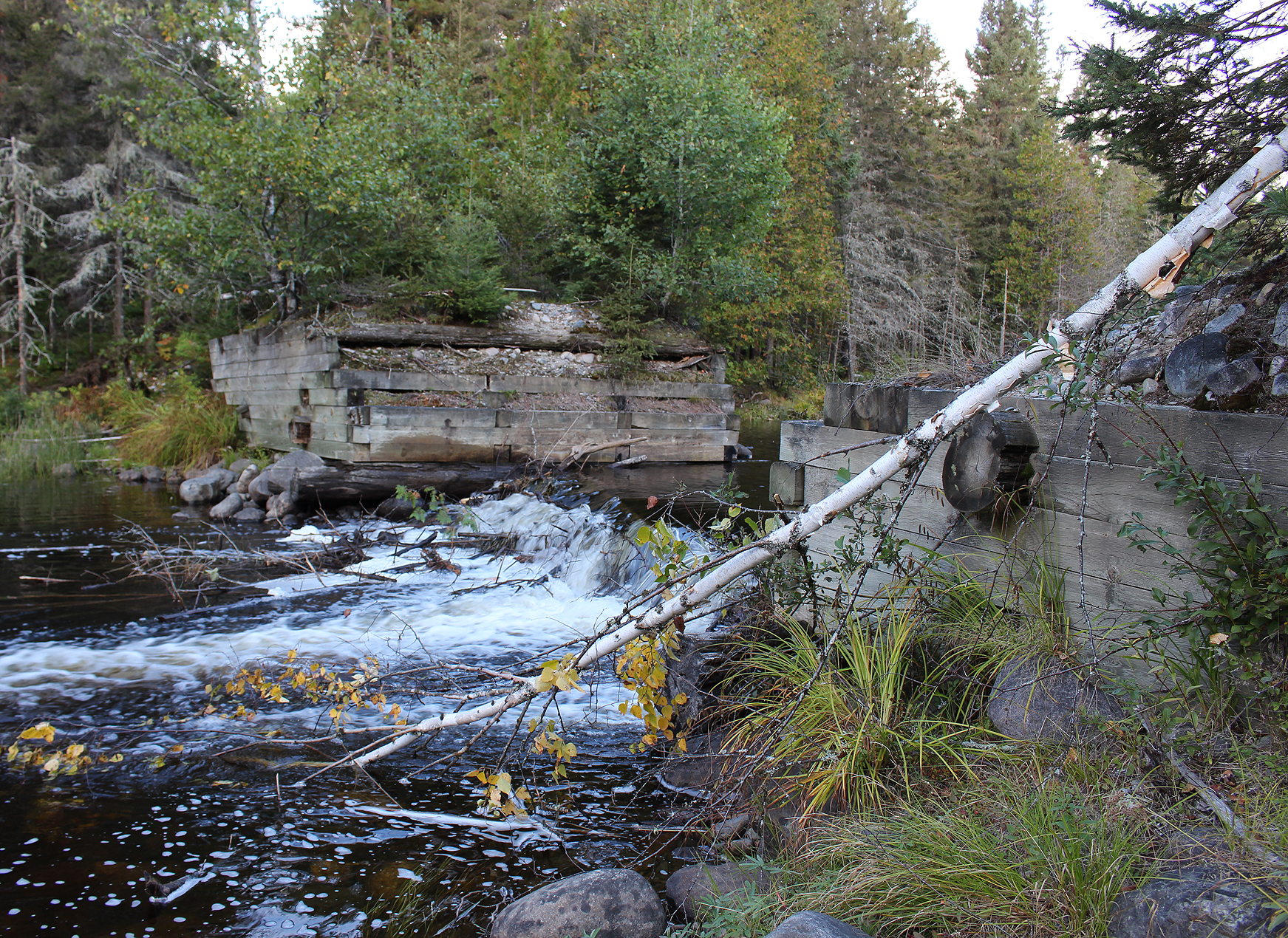
We decided to have lunch at the portage along the Lady Evelyn Falls, and to also explore the immediate area which we didn’t do on our first day in. During the early 1940s the A.J. Murphy Lumber Company had a log dam constructed here to haul logs from Diamond Lake to Lady Evelyn Lake, and then down the Montreal River to the town of Latchford. Logs were also floated over from Lake Temagami until around 1960. The MNR blew up the dam in 1973. If it wasn’t for blowing up the dam we would have had a hard time seeing the Diamond Lake pictographs we saw earlier on the trip as the dam raised the water levels. As we explored the area where the dam once stood it didn’t take long before we discovered some remnants in the form of cables and anchors.
For a write up about this spot and what the damn used to look like please see the following link:
https://www.ottertooth.com/Temagami/History/ladye-liftover.htm

Sunny skies were forecasted for the day, though once again Environment Canada was a little off in their ability to read weather models, as it was mainly cloudy until the sun finally made a welcomed appearance in the afternoon.
Back in the canoe we paddled in the narrows, before turning west and entered the main body of Diamond Lake. Diamond Lake lives up to its name as this jewel of a lake is very scenic, including many small islands. We really wanted to get to the west end of the lake, but the headwinds had other plans for us, and we made it as far as the group of islands in the middle of the lake. It was only around 3:00pm at this point but we really didn’t feel like working out our arms any longer.
The island site we chose is a well used site. The takeout/put in was okay, there was a good seating area around the firepit, and a flat spot for the tent. There was also a decent spot to bath which we took full advantage of as we haven’t bathed in a few days. After setting up camp we relaxed and explored around the site.

Diamond Lake is located in the more heavily traversed area in the Temagami region, and unfortunately we do notice some negative human impact here. At this site it was clear that someone got bored and decided to hack away at a couple of Red Pine.

Also disappointing was the Environment Canada forecast. With no rain called for today we had a lot of our gear out around the fire pit as we got a smokey fire going to get rid of the no-see-ums. Just as we sat down for supper it began to rain and we had to quickly grab all our stuff and flee into the tent. After we got into the tent, got everything organized and comfortable, Aaron felt a repeated biting sensation on his leg. He rolled up his pants and there was a huge black and yellow coloured wasp! We smacked it a few times but smacking something on top of a fluffy sleeping bag doesn’t work so well. To avoid pissing it off even more, Aaron caught it in his mid-weight and flung it outside. That’s enough excitement for one day thank you!

Wildlife Sightings: Red Squirrel, People, Red Crossbill, Common Loon, Common Raven, Red-breasted Nuthatch, Pine Siskins, Pileated Woodpecker, American Crow, Mosquitoes, No-see-ums.
Remember to: Fix the campsuds lid…it’s cracked and is now leaking.
DAY #9: Diamond Lake to Wakimika Lake (Obabika River Provincial Park)
Weather: Cloudy with light showers in the morning. Clouds and peaks of sun in the afternoon with a slight breeze. High: 16C Low: 12 C

Environment Canada forecasted 60% chance of rain today, along with a chance of a thunderstorm to the south of us. With this bit of information, we decided to go as far as Wakimika Lake today, as the prospect of getting stuck on the Wakimika River in a thunderstorm didn’t sound appealing.
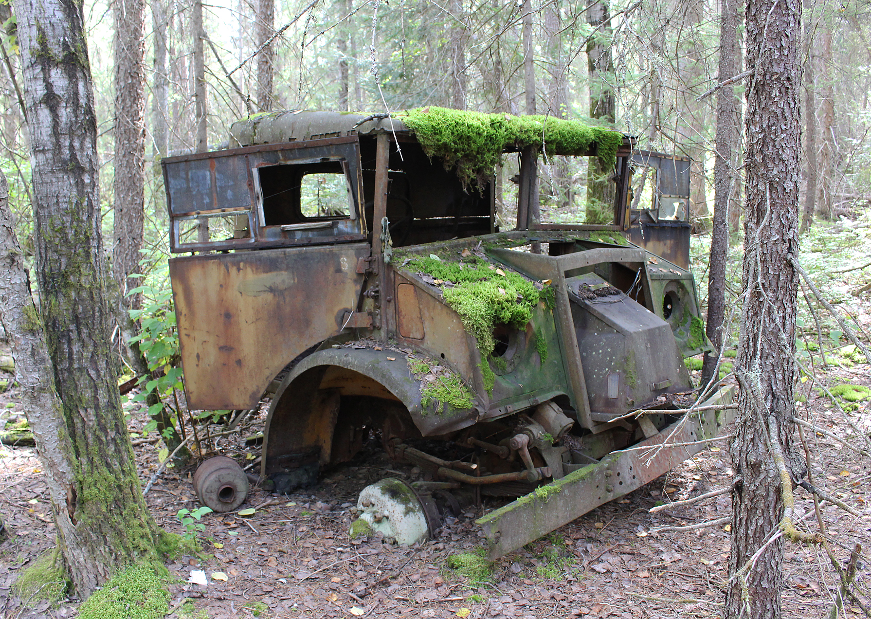
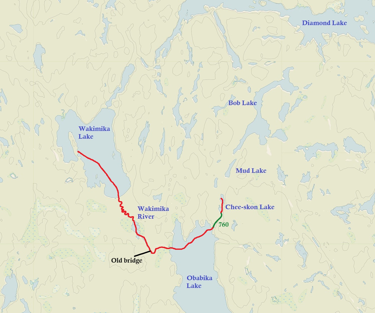
We left our Diamond Lake site under cloudy skies, and it was very calm. It was like we were on a totally different lake than the windy lake we were on yesterday. At the west end of Diamond Lake is an old logging camp. As we approached the shore there was what looked like what can only be described as a break wall of rocks offshore, which we assume was manmade? As we paddled towards the shore we saw a couple of tires in the water. Pulling the canoe up we located a bit of a clearing in the trees and walked down a well defined path. Before we knew it there were logging remnants all around us including carts, a sled, buckets, remnants of a building, along with other items that we had no idea what they were. This extensive logging camp was used from the 1940s into the 1950s. Not sure if it was run by the A.J. Murphy Lumber Company that also had the dam built at the Lady Evelyn Lake lift over, but it looked like at one point it may have been an impressive operation!


As we continued to explore some sprinkles of rain started to fall which continued on and off throughout the morning. We probably spent a good half hour exploring the site. It would be neat to find some photos of what this area was like when it was up and running. We got the impression that people not only worked here but maybe even settled here for a while, as the site including buildings that have long since collapsed, now slowly being swallowed up by the earth.
We had two portages today. The first one at 310 metres towards Lain Lake was a little annoying. The rocks along the portage were spaced so that you could not easily hop from one rock to another, but instead we had to alternate between climbing up, or going around them. There was also a section where we carefully walked along a wet and somewhat slippery ledge of rock. Thankfully, waiting for us at the end of the portage was a nice flat rock right at the put in.
A very short paddle later and we were at our last portage for the day. At 390 metres it included a short walk down the now abandoned Red Squirrel Road. Boy does this section of road have some history to it! Ever since the mid 1980s there were plans to extend this logging road into the Temagami wilderness, and in 1988 the OMNR approved its extension. This extension also included land that belonged to the Anishinabe and they, along with local environmentalists among others that didn’t want to see the forest logged, took to protesting in Temagami and at other locations in the province of Ontario. The clearing of the Temagami wilderness, including stands of virgin forest, made national news headlines. A lot of people saw what appeared to be the injustice of the clearing of forests, with little say from the concerns and interests of its citizens. There was even a benefit concert featuring musicians like Gordon Lightfoot among others that raised money for the Temagami Wilderness Society. From September to November 1989 on the stretch of proposed road towards Wakimika Lake there was a protest that lasted for over 50 days, with the base camp located along a nice stretch of beach on Wakimika Lake just to the south of the road extension. The police came in and made multiple (over 100!) arrests during that time. The first arrests on September 18th included that of Bob Rae, who a year later would become the Premier of Ontario, and now sits as our current ambassador to the United Nations.
For photos of the protest including Bob Rae’s mugshot, click on the following link:
https://www.ottertooth.com/Temagami/env/temagamiwildernesssociety-blockade89.htm

After portaging along Red Squirrel Road we had only a short paddle in Pencil Lake until reaching the beach at Wakimika Lake. No lines of tents like that of the protesters back in 1989, as we were the only souls here. We debated camping here, but honestly the beach didn’t look that inviting to us. The wind was still calm, though there were some ominous looking clouds growing in the north, so we decided to paddle close to the north shore until we arrived at a site with a bit of a tricky take out. We took our packs out of the canoe, but as we explored around the site we couldn’t for the life of us find one flat spot for the tent! No way we were staying here!
The breeze was now picking up so we threw our stuff back in the canoe and made a bee line towards the western shore. We picked the second site on the western shore that had a sandy take out which was so nice! There was a nice little hike up to the top of the site. The site was barely used with a flat spot just wide enough for our tent. We also set up Magitarp right away as we expected rain. As we were organizing our stuff Marianne spotted a couple in a canoe heading north into the head winds…we felt their pain.
Aaron had a nap while Marianne perched herself on a nice flat rock at the top of the site and watched the lake and clouds. Jack Pine was the dominate tree here including some growing right out of the rocks, and we wondered how old some of them are? Rumbles of thunder and darker skies built up to the south of us. Winding up our little weather radio and getting the local weatherband we learned that there were not only storms, but a rainfall warning for North Bay. It can stay there, please.

High up in the sky there were a few lines of Canada Geese migrating south this evening, including a few flocks even after sunset. Fall is on its way.
Wildlife Sightings: Common Loon, Red Squirrel, Red-breasted Nuthatch, People, Yellow-rumped Warbler, Northern Raven, Canada Jay, Pine Siskins, Common Merganser, American Toad, Bald Eagle, Canada Goose, American Pipit, People.
Remember to: No remember to today! Yay!
DAY #10: Wakimika Lake to Chee-Skon Lake (Obabika River Provincial Park)
Weather: Mix of sun and clouds in the morning, with sun in the afternoon. Slight breeze. High: 15 C Low: 10 C
We weren’t sure what kind of day we would have today as it included some river travel this morning, so we set the alarm for 5:00 am with only bars and tea for breakfast. We took the tarp down in the dark and were on the water by 7:15 am under mainly cloudy skies and some choppy water. Some flagging tape signaled the beginning of the Wakimika River, and we thank the person who tied it as it would have been a tricky spot to find from the canoe. We were hoping to finally see our first moose for the trip out here, but it was not to be. In fact, we have barely seen any signs of moose on our whole trip thus far! Only maybe a couple of piles of moose droppings and we haven’t even located any tracks along portages, or at takeouts/put ins.
The Wakimika River winded mainly through an area surrounded by trees with only a small stretch of marsh. The water also appeared to be high, and so we had no lift overs to contend with. We had a quick portage around an old, decommissioned logging bridge, where we had a quick break/snack. A short paddle later and we arrived at Obabika Lake which is a big, long lake, and we were relieved that the water was only slightly choppy. We only had a short paddle along the north shore of Obabikia Lake as we made our way towards the 760 metre portage. A nice beach take out met us and we observed a tent set up on shore nearby.
We started out on the portage and before too long we met a lovely lady who was the owner of the tent we just observed. She stated that she was out for a week long trip, specifically on the lookout for mushrooms. She also mentioned that she heard the portage to Mud Lake was impassable. We would be attempting that trail either today or tomorrow, so we hope she is mistaken on its condition.
After parting ways we continued on the 770 metre portage. This section of Temagami may have been what could only be described as the most magical place we have ever been in the province of Ontario! We were now in the Wakimika Triangle Old Growth Forest Trails, a network of trails of old growth forest now protected as a conservation preserve. There were huge White Pine and towering Red Pines along the trail! The forest floor was also very lush as well, and we wish we knew more about botany etc. because we could have had a field day just exploring the local flora. Honestly the area had an almost fairy tale like aura surrounding it as there were more birds singing here than anywhere else on our trip! In essence it was like we stepped back in time, a time before the land was altered for human interests.

We soon got to the end of the portage and onto Chee-Skon Lake which was windy. An impressive white rock face soon met us on our right side. This, known as Chee-skon-abikong, “place of the huge rock” is a spiritual place of healing to the indigenous people of the region and is still used today. On maps you will see it labelled as “Spirit Rock”.
We hoped that by arriving early enough the single site on this lake would not be occupied. As we paddled closer to the site we smelled the faint scent of a campfire, but lucky for us it was the leftover smoke from a fire that was just put out, and the site was ours! Whoot!

After we set up our tent and had a quick lunch it was time to grab our day pack and explore more of the Wakimika Old Growth Forest Trails. We also went to check out the portage to Mud Lake to see if it was indeed impassable. It was definitely doable, but it was going to be a sloppy mess!

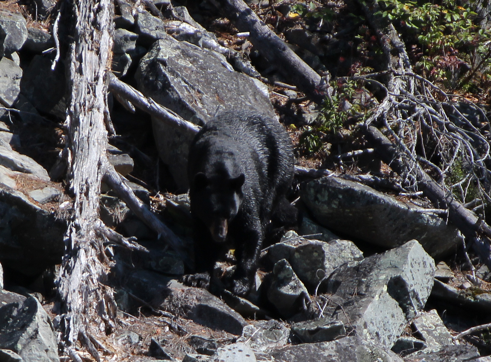
Back at our site it was time to enjoy the rest of the afternoon by relaxing out in the sun next to the water. While laying back Marianne heard a splash and soon she spotted a Black Bear on the other side of the lake, slowly making its way along the shoreline. He rarely paid attention to us, just looking up once and kept on going about its business. Later we collected some firewood for tonight as well as for tomorrow.
We stayed out as late as possible tonight, until the fire waned and it got a little chilly. It’s supposed to go down to 0C overnight, and there was definitely that chill in the air as we retreated to the tent for the night.

Wildlife Sightings: Red Squirrel, Red-eyed Vireo, People, Common Loon, Pine Siskin, Red Crossbill, Northern Raven, Red-breasted Nuthatch, Yellow-rumped Warbler, Pine Warbler, Winter Wren, Canada Geese, Downy Woodpecker, Wood Duck, Black Bear, White-throated Sparrow, Frog, Bat sp.
Remember to: No remember to today! Whoot!
DAY #11: Chee-skon Lake to Diamond Lake (Obabika River Provincial Park)
Weather: Cloudy in the morning with a mix of sun and cloud in the afternoon. Breezy. High: 14C Low: 2 C

It was chilly this morning, making it more of a challenge to get out of the warm sleeping bag and out of the tent. During the pre-dawn hours we heard the faint “toots” of a Saw-whet Owl. We got out of the tent around 6:30am and warmed ourselves up by gathering a bit more firewood for a breakfast pancake over the coals.

We really didn’t want to leave such a great site, but our canoe trip was coming to an end soon. Wearing a few layers as it was just above freezing out, we slid the canoe into the calm waters of Chee-skon Lake and departed this almost surreal piece of paradise.

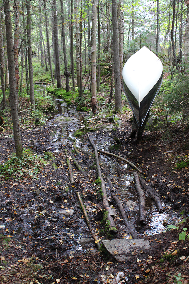
Getting out of the canoe we began to warm up a bit along the portage to Mud Lake. The last length of this 760 metre portage was the muddy mess we saw the day prior, so we just took our time and watched our footing as we tried to stay on the logs that were placed out by previous travelers. At the very end of the portage at the put in you had to really watch not to step in the mud unless you wanted to go above your ankles…..or maybe even your knees? We didn’t want to find out. After a short paddle we arrived to a 260 metre portage which, from the vantage of sitting low in a canoe, was a little bit tricky to locate the take out along the shoreline.
After a quick portage we arrived on Bob Lake, and we were now in the Bob Lake Conservation Area. This is crownland so if we were to camp here it would be free for us Canadian citizens, but we were only passing through. Paddling north we observed someone camped at the site along the eastern shoreline. After a paddle into some headwinds we stopped off at a site along the western shore that once held a logging camp. Now a camp site the vegetation here was quite scruffy due to it being cleared decades ago, and if we had to choose we wouldn’t want to camp here. Wandering around we saw a few items, but not as much as at the other two sites we visited. We heard a rumble in the distance and soon recognized the sound of what was probably a large truck as the forest road is nearby.

Back into the canoe we paddled north to the 1210 metre portage, the longest for the whole trip, that would take us back to Diamond Lake. We had no idea what to expect with this lengthy portage, so we decided to have lunch here before tackling it.
We began the portage with just our packs and we were pleasantly surprised that it was one of the easiest portages of the whole trip! For the most part it was flat, and it looked like it used to be (or at least part of it was) an old logging road. There was one section that was all birch, perhaps signs of succession if this area was once logged, or maybe even a forest fire. We eventually crossed over the Red Squirrel Road yet again, and what may have been a road from quite a while ago, now all overgrown.
The portage eventually descends down towards Diamond Lake and as we approached the put in there was a nice sandy beach. Back on Diamond Lake there was a little bit of a chop to the water but nothing too annoying. While paddling we heard a tree fall in the distance, perhaps taking out a few of its buddies in the process. We also observed a motorboat, and a short time later we saw a single canoe. A Bald Eagle called and flew off its nearby perch as we made our way towards the eastern end of the lake. Fall colours, something we haven’t noticed yet on this trip, were now starting to appear with pops of yellow birch leaves dotting the dominant green foliage. We settled for the site at the eastern end of Diamond Lake that is located on a peninsula. There is an okay put-in, and a couple of flat spots for a tent. Though the rocks at the water’s edge were extremely slippery, Aaron managed to slide in for a quick bath.
The one unfortunate thing at this site was that someone decided to move the firepit right beside the best flat spot for our tent. It was also at an inappropriate spot as it wasn’t on rock but located on an organic dirt surface with trees. We cleaned it up and dumped what little contents there were in the other firepit located on exposed rock. Clouds dominated the sky all day, but eventually the sun came out in the late afternoon, and the breeze calmed down making it an enjoyable late afternoon/evening.
American Pipits and Horned Larks are two species of songbirds that are on their fall migration, and both paid a visit to our site this afternoon. This included one extremely cooperative Horned Lark that didn’t mind our presence whatsoever. Breeding up in the high north perhaps we were the first humans it has ever interacted with?


During the calm of the evening we tried to improve our new menu item for our camping trips, that being Minestrone soup. This time we added some dried soup mix, along with some dehydrated zucchini which helped it out a lot! We’ll have to remember this recipe for the future as it is a warm quick prep meal when you don’t feel particularly hungry.
We are within a day’s paddle back to the car, but we definitely don’t want to leave yet! The weather has been in our favour for almost the entire length of the trip, and we have travelled to so many beautiful spots and interesting locations that we just want to keep exploring!
Like the previous evening it cooled off pretty fast after sunset and we didn’t bother with a fire tonight as we weren’t sure if the winds were going to calm down enough, so instead we retreated to the tent to play cards until lights out. Tomorrow we will continue to retrace our steps back to Lake Temagami for our last night! Nooo! 😦
Wildlife Sightings: White-throated Sparrow, Pine Warbler, Red-eyed Vireo, Ruby-crowned Kinglet, Hairy Woodpecker, Golden-crowned Kinglet, Red-breasted Nuthatch, Pine Siskins, Red Crossbill, American Pipit, Horned Lark, Bald Eagle, People, Common Loon, Common Raven, Frog (Green), Black-capped Chickadee, Canada Goose, Pileated Woodpecker
Remember to: No remember to today ya!
DAY #12 Diamond Lake to Sandy Inlet – Lake Temagami
Weather: Sunny skies High: 18 C Low: 3C

Because we didn’t have far to go today we let ourselves sleep in until 6:30am. We were also close to a forest road and we could hear the rumble of a large truck in the distance.

A little bit of fog this morning as we had our tea and oatmeal for breakfast, but as the sun rose so did the fog off of the lake. We launched onto Diamond Lake’s calm waters and made our way back to the now familiar Sharp Rock portage, so aptly named as the rocks you step on and over are actually quite sharp. The pair of boats with the Ontario Parks stickers telling them to move them out of the area were still there. We tried to find the remains of the Jack Ladder again which was used to haul logs into Lake Temagami from Diamond Lake. We found some metal slabs, some foundations, what looked to be some kind of metal shoot, and some wood strewn about. We portaged over the Red Squirrel Road and arrived back to the Sharp Rock Inlet of Lake Temagami. The boat at the edge of the water was still there….and will probably be for a long time.
Paddling east on Lake Temagami it was a picture-perfect day. The water was calm and the sun was shining. There were others out enjoying the day as well as we observed others out on motorboats. Just before we arrived at our last and final portage for the trip we stopped off at a site to stretch our legs and have some GORP.
We didn’t hike Napolean Mountain on day one of our trip so we decided that we would give it a go today. While hiking along the portage we couldn’t find a well-defined trail so we decided to forego this little excursion. At the put in is a really nice sign to tell others to be aware of posion ivy which we did see along the shoreline.

Back on Lake Temagami we were debating whether to camp at the beach sites beside the launch or take one of the campsites on the opposite shore. We decide on the beach sites as we would get the sun all day, a fitting end for our trip on a picture perfect fall day!
The beach site was large, and even though there was some litter it was still fairly clean. There wasn’t much of a firepit and no seating area, just sand. Instead of a thunderbox there was an outhouse which looked really sketch! Wandering around towards the back of the site we saw that others chose to not use the scary outhouse as there were some toilet paper bombs strewn about. It was far enough back from the site that we didn’t care, plus we would be spending the rest of the day relaxing on the beach. No worries for finding a spot to pitch a tent. Everywhere was a flat spot 🙂
As Aaron made a spaghetti lunch a Black-backed Woodpecker, the only one we observed for the whole trip, arrived on a nearby tree. After lunch we decided to take a hike along the portage that led back to the car. We were curious to see if it would start, and if any of the water went down in those huge puddles. We were happy to see that the water had in fact gone down quite a bit. This was a bit of relief as we were seriously thinking about how we might take some of the water out of the puddles so as not to have it go over the hood of the car again! We were also relieved that we kept the inside of the car clean enough that no mice made it in, an issue we have had in the past when leaving our car at a launch for almost two weeks straight. Besides any leftover food, mice love to shred toilet paper, so we had everything in containers. We also left mouse traps in the car and none were snapped.
On the hike back to our beach site we met a couple in a Swift canoe that were just getting ready to head out on a four day trip. When we told them that we were staying at the beach site for the night they asked us if we knew about the “nuisance bear” that was known to frequent the area. This wasn’t a complete surprise to us as the beach site is located in an area of crownland that sees a lot of human visitors/campers. Looking at the time it was around 2:30pm, and the prospect of having a bear stumblebum around our site on our last night didn’t sound all that appealing. Arriving back at our beach site we debated on paddling to one of the sites across the lake, or just pack it in. In the end we decided to take down the tent, pack up the car, and head out. Of course this was not without one last look over the beautiful blue waters of Lake Temagami.
We had a great trip! This was our favourite trip yet to the Temagami wilderness and we will definitely be back again as this area has so much to see and explore!
Wildlife Sightings: Grouse species, Horned Lark, Common Loon, Red Squirrel, American Pipit, Blue Jay, Pine Siskins, Dark-eyed Junco, White-throated Sparrow, White-crowned Sparrow, Golden-crowned Kinglet, People, Frog, Fish, Pileated Woodpecker, Black-backed Woodpecker.
Remember to: Return to Temagami again!

Click The Link For More Trip Reports:
