

The Temagami area in northeastern Ontario has been called the “heart of canoe country” and “a paddlers paradise”. At 16,000 square kilometres, (Algonquin Provincial Park is around 7,653) this vast area includes crown land, 16 provincial parks, 26 Conservation Reserves, and almost 50 trails in the backcountry! Temagami seems to offer something for all outdoor enthusiasts whether it be camping, boating, hiking, hunting, fishing, cottaging, you name it! The area lies in what is known as a transitional forest area with the Boreal Forest to the north and the Great Lakes-St. Lawrence Forest area to the south. The area is rich in both natural and cultural heritage. Portages, including those on our route have been used for thousands of years by the native people of the area. Like other areas in Ontario’s north, logging continues its legacy here. This was made very clear to all Ontarians back in the 1980s and 1990s when individuals protested, some for months, in both the Temagami wilderness and at Queen’s Park. People blocked logging roads, tied themselves to trees, and camped out to try to stop workers form entering. Arrests were made, including former NDP leader Bob Rae who rallied behind the protesters.
Logging companies, environmentalists, local Temagami First Nations, canoeists, cottagers, fishing guides, lodge operators, and other locals from the town of Temagami, we all continue to have a stake in the natural world where we live, work, and play in. Temagami may be 16,000 square kilometres but to please everyone it almost feels like it could never be big enough.
For some reason we have never been successful in completing a planned canoe trip in Temagami. Our first trip was back in June of 2013 which was cut short due to nearly being destroyed by mosquitoes and blackflies. With the locals commenting on how bad the bugs were that particular year we didn’t feel too guilty in bailing out early. We also left early on our last trip to Temagami in September of 2020 due to foul weather, and the added discovery that our rain gear was no longer waterproof. Well we are proud to say that third time’s the charm as we actually finished our planned route in what would turn out to be our most challenging trip to date! In 11 days we portaged and paddled within three provincial parks (Lady Evelyn Smoothwater, Sturgeon River, and Solace) as well as in the Yorston Conservation Reserve. We had beautiful lakes with some virgin forest, rapids, steep rocky portages, boot sucking bogs, sandy beaches, gorges to portage, along with head winds, tailwinds, torrential rains and thunderstorms. If that doesn’t make a successful canoe trip then we don’t know what does!
There is a saying that if you’ve paddled Algonquin, Killarney, and the Boundary Waters/Quetico, then you are ready to paddle Temagami. We can definitely attest that this saying is true! This place is both stunning and rugged, and we will be returning for more on future canoe trips!
As stated, Temagami is made up of different provincial parks, crownland and conservation reserves. If you are a Canadian citizen you can stay up to 21 days at no charge at the same site on crownland. What isn’t so great is the price for staying in the provincial parks that make up the “Temagami Cluster”, at a whopping $36.73 per night! Not so great if you are a couple, or especially a soloist! Just to put this into context it’s $12.43 per person for backcountry in Algonquin Provincial Park. Booking online with Ontario Parks is also different; This is one of the few parks where you don’t book 5 months before your start date, but rather a mere 2 weeks. You also don’t book the lakes you intend to camp at but rather your entry point, followed by what area you will be spending that night in, whether it be a provincial park (fee) or crownland/conservation reserves (no fee if Canadian).
Compared to other provincial parks we have travelled, the feeling of remoteness is up there with Quetico, though some sections we were in felt more isolated than anywhere we have been before. We saw one other group of canoeists three separate times on our whole trip, and if it wasn’t for them we wouldn’t have seen any other paddlers after our first day in! This worked out great for us as the risk of running into a site that is already taken is extremely low, and sites can be few and far between in some areas. We ended up being able to stay at all the sites we had our eyes on, though going during the month of September probably also had something to do with it.
We can’t say for sure if all of Temagami has portage and campsite signs and we were glad that our route had them, especially since some take outs were more obscure than others. All but one of our sites had a thunderbox, and that was the one on crownland.
Total Days: 11
Total Kilometres: approx. 125 kilometres
Total Portages: 36
Total Portage Length: 20 kilometres
Longest Portage: 3.130 kilometres (Gamble Lake to Junction Lake)
Average Daytime High: 18.5 Celsius
Average Nighttime Low: 14.5 Celsius
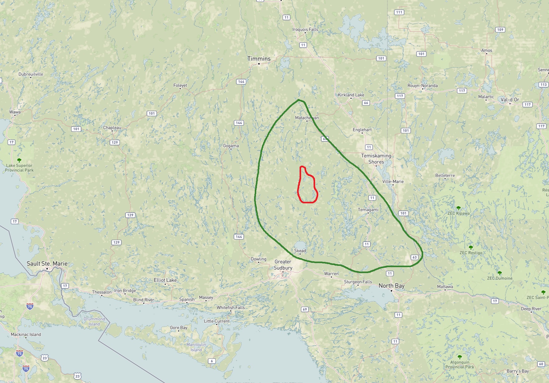
Route: Montreal River Launch – Montreal River – Lady Dufferin Lake – Montreal River – Smoothwater Lake – Apex Lake – Unnamed Lakes (3) – McCullough Lake – Mihell Lake – Scarecrow Lake – Woods Lake – Scarecrow Creek – Little Scarecrow Lake – Hamlow Lake – Regan Lake – Melanson Lake – Tooth Lake – Carrying Bar Lake – Broadbent Lake – Biscuit Lake – Einer Lake – Solace Lake – Samson Lake – Bill Lake – Pilgrim Lake – Rodd Lake – Benner Lake – Bluesucker Lake – Florence Lake – Florence River – Duff Lake – Jack’s Lake – South Lady Evelyn River – Dees Lake – North Lady Evelyn River – Chance Lake – Gamble Lake – Junction Lake – Unnamed Lake – Sunnywater Lake – Wilderness Lake – Marina Lake – Smoothwater Lake – Montreal River – Lady Dufferin Lake – Montreal River – Montreal River Launch
Maps Used: Chrismar Temagami 4 (Northwest and Sturgeon River). Jeff’s Map Temagami (North). Ottertooth Maps (Smoothwater, Ishpatina, Solace, Upper Yorston, Florence, Tretheway). A Wilderness Paradise by Hap Wilson
Books Used: A Wilderness Paradise By Hap Wilson

DAY # 1: Montreal River launch to Smoothwater Lake (crownland to Lady Evelyn Smoothwater Provincial Park)
Weather: Sunny with some clouds, breezy. High: 27C Low: 14C

After staying overnight in Timiskaming Shores we were on the road just before sunrise, driving west with the canoe strapped on the roof of our car. Our first stop was a McDonald’s for a BLT bagel, hashbrown, and our last coffee for the next 12 days. Leaving Timiskaming Shores it’s an interesting drive as you travel through the wide open farmland of cash crops and cattle, a stark contrast to the trees and rocks that have flanked Highway 11 since north of Lake Simcoe. The view of farmland is short lived with the transition back to trees, rocks, and rivers. Turning down Beauty Lake Road the landscape changes yet again as you go from a paved highway to a gravel logging road with different stages of clear cut on both sides, along with stretches of road that require both hands on the steering wheel.
Shortly after flushing a Spruce Grouse we arrived at the launch next to a bridge that goes over the Montreal River. We were not the only ones here as there was a group of hunters staying at the site located beside the launch, along with a couple of guys having breakfast before heading out for a weekend canoe trip. Around 8:30 am we slid our canoe into the water and we were on our way under sunny skies!

Paddling up the Montreal River we approached our first man made landmark for the trip, the remains of where an old road used to cross over the river. We can only assume it was once a logging road. We also observed a few species of birds including a group of Common Mergansers, a bird that more often prefers to scurry in front of the canoe instead of just flying away. A couple of Solitary Sandpipers patrolled the shoreline, searching for invertebrates as they fuel up for their migration south. There was also a Bald Eagle, the most common raptor we would see on our trip, perched at the top of a high tree right beside the river.
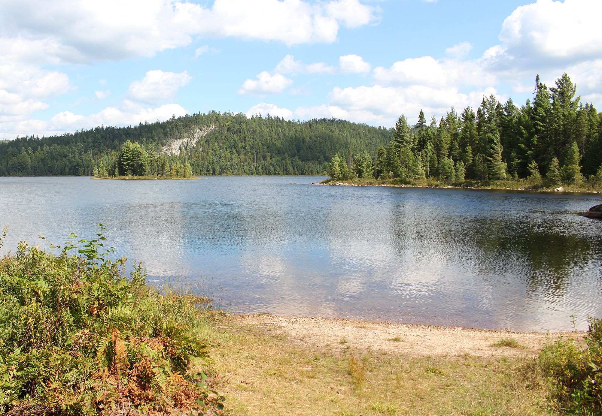
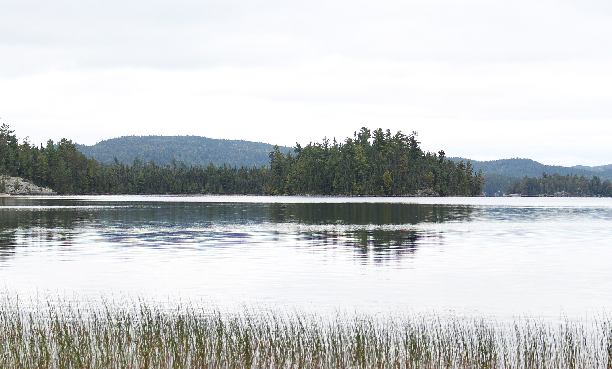
As we paddled through watershield and gently waving maiden’s hair we soon found ourselves on Lady Dufferin Lake. As the lake widened we had a little bit of headwind, though this time it was a welcomed relief as it was getting warm out. Gazing to the east we spotted a cottage among the trees. This is the same area where a brothel once stood between the 1930s and the 1960s, and whether this is the same building, or perhaps someone bought the property and rebuilt, we don’t know. The water splits here, and we drift to the right as we continued up the Montreal River crossing over the invisible park boundary into Lady Evelyn Smoothwater Provincial Park. A short paddle later we reached Smoothwater Lake, a beautiful clear lake surrounded by rolling hills, and the head waters of the Montreal River.

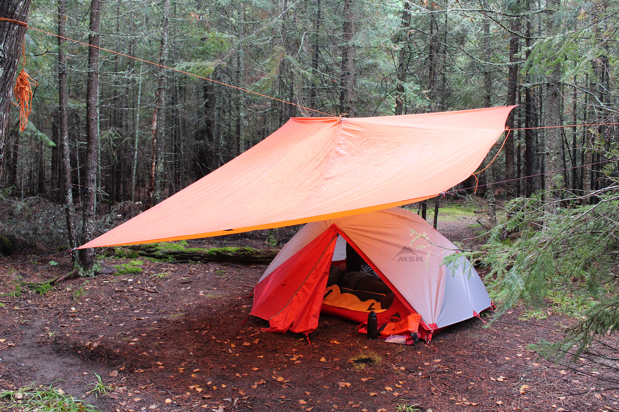
This afternoon Smoothwater Lake did not take after its namesake, with some small swells that slowed us down a bit. Eventually we arrived with a nice smooth landing at the first beach site on the eastern shore. Getting out of the canoe we stretched our legs and our arms to get the most out of the welcomed breeze. We have never been to this side of Smoothwater Lake before, and we looked over the first out of the handful of sites that dot the shore. This one was decent enough as it had a fire pit, and of course being a beach there was the obvious flat spot for a tent. With no other people around we decided to walk down the beach to check out the next beach site, followed by the one towards the end of the beach that sits next to a portage. The one next to the portage is like a 5-star resort in the backcountry!! There is a wide beach, a perfect flat spot for a tent, the sound of a small stream to help you sleep, and oh my gosh a picnic table!!?? We quickly walked back, grabbed our canoe and packs, and paddled over to claim the spot!

At such a 5-star site there was also a good fire pit with a grill, and we made a spaghetti lunch here. Marianne also found a journal stashed away that was like a guest book and she signed it. Continuing to explore the site we located the thunderbox which was a good distance back from the site, and two separate memorial placques on a couple of trees. This must’ve been a special place for many paddlers and just by looking around we can see why.

After setting up the tent we walked down the 120 metre portage to Marina Lake, a cute little lake which, if everything goes well, we will be entering from the other end in 10 days or so. A Belted Kingfisher seemed to like the stream behind our tent and chattered away as he landed on a nearby branch. Aaron also liked the stream, and he played in it where it meets the lake at the beach.
As the afternoon continued the two other beach sites became occupied. The first one by the two guys we met earlier out for the weekend, while at the other one we could make out three red and white Swift canoes. After pumping water for tomorrow we hung our packs, not for bears but for mice that (according to the notebook left here) like to come out at night and go through your stuff. As evening approached the breeze calmed and we sat on the beach to watch the sunset behind the hills until the first few stars came out. Walking back to the tent to turn in for the night we heard something small shuffling in the leaf litter. Thinking it’s a mouse we directed the light from our headlamps, but instead of a mouse we found a toad. Curling up in our sleeping bags for our first night in Temagami we were lulled to sleep by the gentle sound of the little stream.

Wildlife Sightings: Red Squirrel, Spruce Grouse, Common Loon, People, Bald Eagle, Black-capped Chickadee, Golden-crowned Kinglet, American Toad, Cooper’s Hawk, Solitary Sandpiper, Northern Flicker, Herring Gull, Belted Kingfisher, Common Merganser, Deer Fly, Mosquitoes, Canada Goose
Remember to: No remember to today! Yeah!
DAY # 2: Smoothwater Lake to Mihell Lake (Lady Evelyn Smoothwater Provincial Park)
Weather: Cloudy with foggy mist in the morning and clouds in the afternoon. High: 19 C Low: 18 C

We had cloudy skies with low hanging fog for our first full day in beautiful Lady Evelyn Smoothwater Provincial Park. The park’s namesake is a combination of both the Lady Evelyn River and Smoothwater Lake, two main water bodies that are located within the park’s boundaries. Smoothwater Lake is also the headwater of the Montreal River which eventually winds its way to Lake Timiskaming. Established in 1973 as a “wilderness park”, Lady Evelyn Smoothwater Provincial Park is the largest Provincial Park in the Temagami region. Within its boundaries lay clear lakes, rivers, and a rugged landscape of forest that includes some old growth. Perhaps the biggest claim to fame within the park is that it is the location of Ontario’s highest peak, Ishpatina Ridge at 693 metres. We hiked the trail to Ishpatina that starts from Scarecrow Lake a few years ago and if the weather is cooperating, is definitely worth the climb! As for Lady Evelyn herself, she was Lady Evelyn Campbell, the sister of former Governor General Sir John Douglas Campbell. Surveyor Robert Bell named a lake, and presumably the Lady Evelyn River, after her in the 1880s.
We were on the water by 8:00 am after a relaxing breakfast of cold cereal and a hot tea at the picnic table. It was cloudy with a misty fog as we departed from our beachside resort. Smoothwater Lake was actually smooth this morning and it was greatly appreciated. Paddling quietly close to shore we flushed an American Pipit which flew ahead of us only to land at the shore again. A migrant from the arctic tundra, now on its way to the southern United States and Mexico, this pint-sized songbird gets to see all sorts of beautiful landforms along its journey. We feel privileged to be able to experience even just a fragment of this beautiful area that the Pipit so easily traverses.
It was a paddle and portage kind of day today, and being out of practice we took it fairly easy by only tackling six portages, at a total of 2,250 metres. Of course we always double over all portages, so in reality that’s almost 7 kilometres…..Vacation Ya!
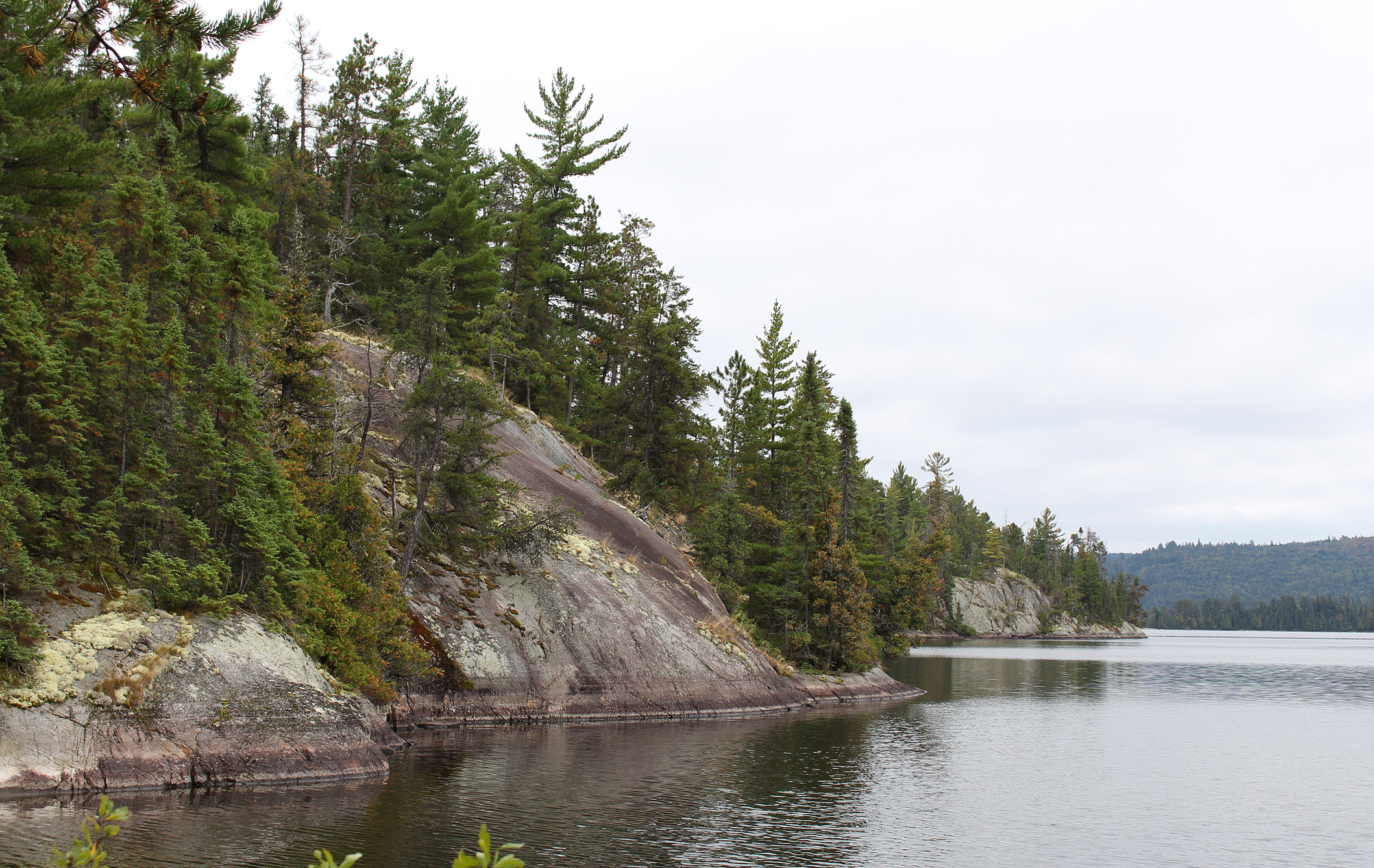
The first out of the six, a 740 metre into Apex Lake, had the most elevation compared to the others. After a short paddle you come to a 1,120 metre portage that actually feels shorter than the 720 metre, but that’s probably because it’s a lot flatter. It was along here that we had a slight drizzle of rain but not enough to have to dig out the rain gear. After an even shorter paddle we reached the 70 metre portage. As soon as you get out of the canoe you see a trail to your left and another straight ahead that goes up a small hill. We accidently started to take the one to the left, a 1,000 metre portage which would have taken us to the South Lady Evelyn River. A quick back track and we quickly finished the 70 metre portage. At the end of this portage we decided to take our first break and boiled up some water on our stove for some Backpackers Pantry Pad Thai. Aaron got the brilliant idea to use the time that it takes for the meal to rehydrate to load up the canoe, paddle to the next portage, and just finish that one at a mere 30 metres. The 30 metre portage is a neat one as it is incredibly flat and also includes a cute archway of trees through it. Here we now sat down to enjoy our lunch that was now properly rehydrated. After another short paddle we approached the 170 metre portage that takes us to McCullough Lake. This lake is quite clear, similar to those that we see in Killarney. We wonder if the lake is naturally this clear due to the geology of the lake, or perhaps had some adverse affects of acid rain from the 1960s and 1970s.
Our last portage of the day was a 120 metres which had a camp site at the beginning of it. The site looked good to use in a pinch, but not inviting enough for us to consider staying there. By this point it was after lunch and we decided that if it was available we would take the site on Mihell Lake which was our next destination. The put in to Mihell was very shallow and we had to shuffle in the canoe a bit to get mobile, followed by a quick lift over, one of the very few we had for the whole trip. While paddling out in the open waters of Mihell Lake we noticed that we actually had some tailwind! Whoot!!! We arrived at the one site marked on our map which we stayed at a couple of years ago. It has an okay put in/take out, the widow maker next to the fire pit was still standing, and new this time was a brand spanking new thunderbox! WOAH! Aaron had a power nap after we got everything on shore, and later we had what barely classified as a bath (mainly two grown adults flailing and shivering).

Sheppard’s Pie with stuffing (basically instant potatoes with veg and stuffing) was on the menu over the fire tonight. While getting things ready for supper the party from Smoothwater Lake in the three red and white canoes arrived to greet us, and we kind of got the idea that they wanted this site. We thought maybe they would turn around and go back to the portage site, but instead they kept going to Scarecrow Lake? Maybe we will see them tomorrow.
All in all it was a good day’s paddle for our first full day in the Temagami wilderness. Portages were fine, a few mosquitoes were out but not to the point you had to put on bug spray, and though it was cloudy it was a warm day for the month of September.

Wildlife Sightings: Red Squirrel, Common Loon, People, American Toad, Black-capped Chickadee, Pileated Woodpecker, Golden-crowned Kinglet, dragonflies, mosquitoes, American Pipit, American Redstart, Dark-eyed Junco, White-throated Sparrow.
Remember to: No remember to today. YA!
DAY # 3: Mihell Lake to Regan Lake (Lady Evelyn Smoothwater Provincial Park to Yorston Conservation Reserve)
Weather: Foggy in the morning with clouds in the afternoon. High: 23C Low: 17C

Got the fire going again for breakfast. This time it was that good ol’ classic of the bush, oatmeal. We add quite a bit of extras to ours including dehydrated apples, dried cranberries, walnuts, and globs of brown sugar! On the water by 8:00 am we had a cloudy/foggy, but also a calm morning paddle as we came to a short 130 metre portage, followed by the long but thankfully flat 1,290 metre portage that takes you to Scarecrow Lake. A nice beach greets you at the end of this portage, and we loaded the canoe with ease as we entered Scarecrow Lake with a lovely tailwind. Scarecrow Lake is where paddlers access Ishpatina Ridge, Ontario’s highest peak at 693 metres. At its summit is the decommissioned Ellis tower, a fire tower that was used from 1930 to 1968 after which aerial detection of forest fires became standard. At the base of the trail up to Ishpatina is a campsite that also used to be the fireman’s cabin site. We stayed at this site two years ago and with a little bit of searching you can still see some foundation from the cabin that once stood there. We’ve done the hike up Ishpatina Ridge before, and with today’s fog there was no point in climbing a mountain with no views from the top. This time we paddled through the center of the lake and off in the distance at the old fireman’s cabin site we could see a few overturned canoes, the telltale sign that a site is taken. The island site was also occupied by the party with the three red and white canoes, and we could smell them cooking bacon when we were almost at the southern end of the lake!

Exiting Scarecrow Lake we crossed over another invisible park boundary from Lady Evelyn Smoothwater Provincial Park into Sturgeon River Provincial Park. This park was formed in 1989 and is classified as a “waterway park”. At 7,985 hectares, the park includes rapids, fast moving water, and some scenic waterfalls to name a few natural attractions. Looking at a map it looks like it would probably take a week to paddle the entire river within the park’s boundaries. Like many other rivers in Ontario’s north, it was part of the romantic but also very dangerous history of the river drives, with logs floating down to mills. This included all the way down to Lake Nippissing, where the Sturgeon River ends its 230 kilometre journey.
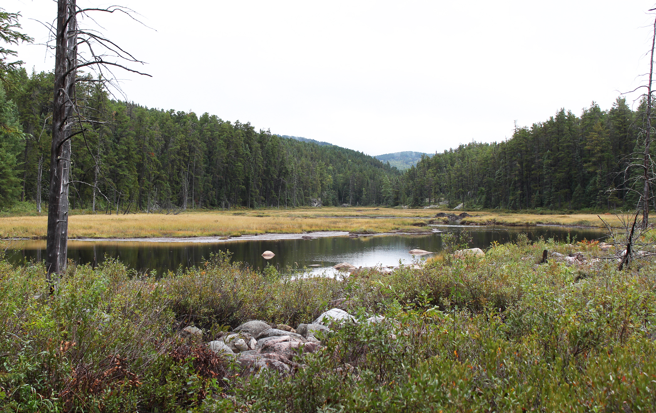
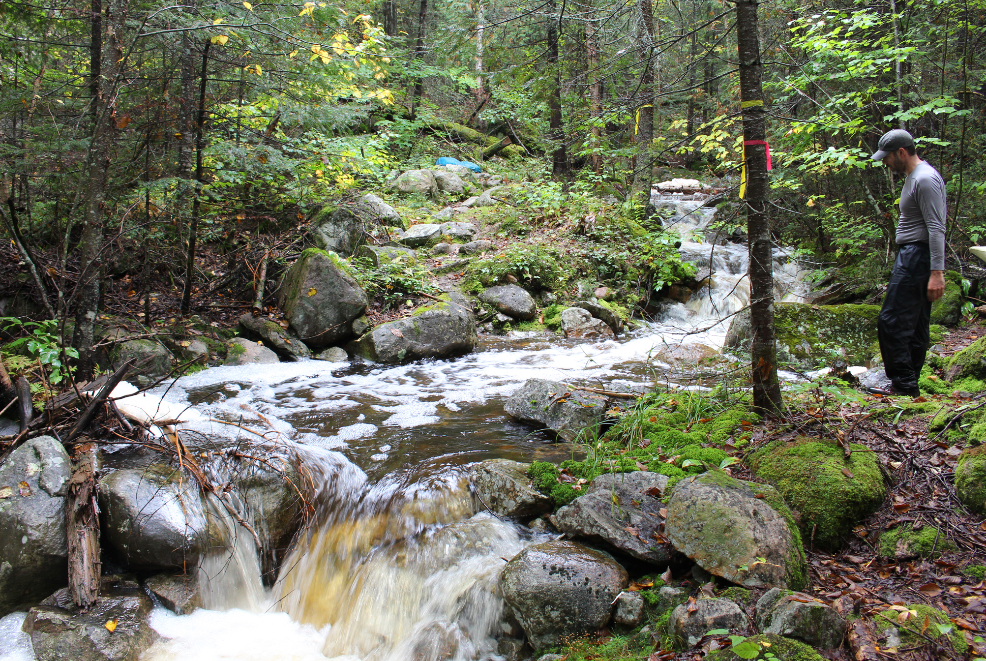
Though we were within the boundaries of Sturgeon River Provincial Park we were not on the river itself (nor would we be) but instead we were on Woods Lake. Woods Lake is a nice lake but the campsites, or at least from the view of the canoe, didn’t look that great. Our next take out at a 140 metre portage was all rocks that took a little bit of foot work, but thankfully the put in at the other end was easy. We soon heard the sound of moving water as we approached our fist rapids for the trip. We almost made it through the first set with only minor scratches to the canoe, but looking ahead it was clear to see that it was time to ditch the hiking boots, put on closed toed sandals, and prep the canoe with rope to line. Lining a canoe was a new experience for us and whether we performed it correctly we have no idea. We had a single rope that we made sure we could pull from both ends with Marianne at the bow end while Aaron had the stern. The current was strong enough that you could feel it push you forward as you waded, though the water never got above knee height. Eventually we made it out of the rapids, along with the clams and crayfish that also call that section home. We were now on Little Scarecrow Lake where we had to perform a lift over at an old wooden bridge, followed by dragging the canoe through a shallow section where an ATV trail crosses into the river.

As we entered Hamlow Lake the sun decided to make a brief but welcomed appearance as we approached a launch where we saw an overturned boat, along with a parked truck and trailer. Coming ashore we stretched our legs and had a quick lunch of bars and GORP. There is a campsite here at the launch which would be great in a pinch. We took a quick walk around the immediate area to see if we could find any signs of the Portelance sawmill site that was here between 1953 to 1979, but we didn’t find anything, nor did we go to great lengths to look either. You know what else we had a hard time finding? The actual portage!
We were now out of Sturgeon River Provincial Park and into the North Yorston Conservation Reserve. Here we observed a few ATV trails that branched out in separate directions, including those not marked on our map. We began to hike down a trail which we thought would eventually lead us to Regan Lake, but after a short time we knew we were heading in the wrong direction. It was time to get out the GPS and figure out where we were supposed to go, and in no time we were on the right track (or rather trail) again. Though our map states this portage/ATV trail is 1,180 metres, there is NO WAY it feels that short! For the first carry over with only our packs we encountered both flat and hilly sections. It was along the hilly section that Marianne secretly hoped that someone, like a prince charming in camo gear, would come by on an ATV and give us a lift. The trail leading to the site we wanted at Regan Lake is a narrow one that leads off the main ATV trail. We were relieved that no one was there when we arrived as the next site on Reagan Lake was only marked on one out of our three separate maps. So maybe it no longer exists?
Our site for tonight was basically a flat spot for a tent, a fire pit, no seating area, and no thunderbox. Walking back behind the site there was a little bit of garbage but no food items that we could see. Though the site was mediocre, Regan Lake sure was pretty when we paddled out to pump water for the evening. We observed a River Otter and heard a couple of ATVS on the trail behind our site while we slowly paddled out on the lake.
Supper tonight was a big ol’ bowl of chili with blue Gatorade to help wash it down. We have a big day of paddling/portaging tomorrow, so we set the alarm for 5:05am as we want to get as far as Solace Lake.
Wildlife Sightings: Northern Raven, Common Loon, River Otter, Bald Eagle, People, Red Squirrel, American Toad, Frog (Green or Mink), Black-capped Chickadee, Pileated Woodpecker, White-throated Sparrow, mosquitoes, Canada Goose, Belted Kingfisher, Hooded Merganser.
Remember to: Next time we make tomato leathers don’t make them so thick as they take too long to rehydrate.
DAY # 4: Reagan Lake to Einer Lake (North Yorston Conservation Reserve to Solace Provincial Park)
Weather: Cloudy with light showers in the morning and afternoon, clearing some by evening. High: 23 C Low: 18C
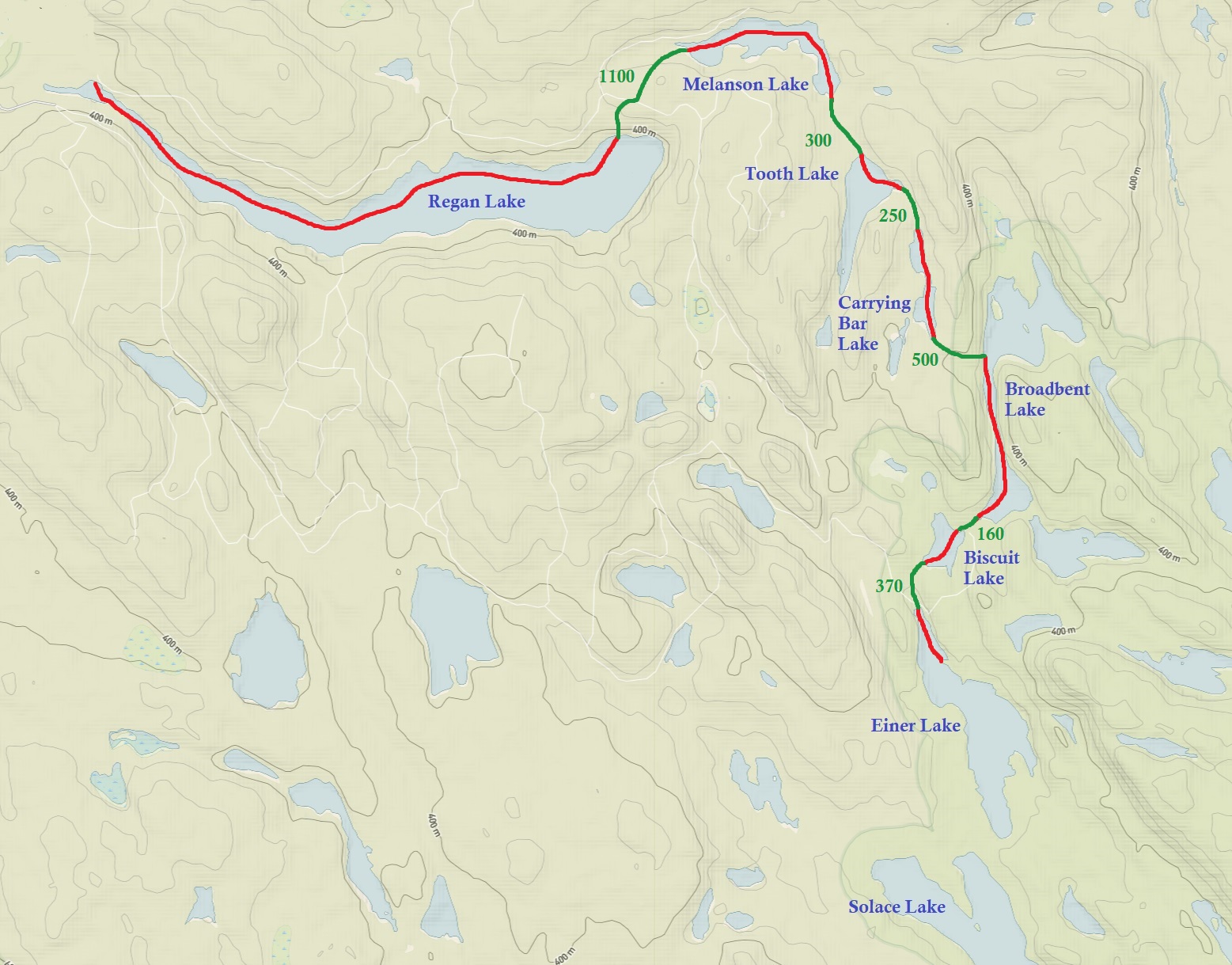
Even though we set the alarm for 5:05 am we were a little slow in getting mobile this morning as there was a light drizzle of rain. It wasn’t until 7:45 am under cloudy skies that we entered a very calm Regan Lake. When the drizzle let up for a bit the lake was like glass and it was very quiet all around us. There is a pretty neat cottage on the north shore of the lake which still appeared to be in use for the season with chairs and other items out on their dock. At the end of the lake we located the portage sign. At 1,100 metres in length it had a very steep climb at the beginning before it connected back to the ATV trail. You have to pay attention here because once again there are a few trails to choose from, though this time we had no problems. The put in at the end of the portage was in a very shallow area just deep enough to float the canoe, our gear, and us.

We are now on Melanson Lake, a narrow lake that we briefly paddled until we got to a shallow and rocky take out. Two out of our three maps state that this portage was supposed to be in poor shape as you basically walk along a creek until it’s deep enough to float a canoe. Unfortunately the creek was so low that we had to walk through the marsh all the way to the end at Tooth Lake, making this 120 metre portage more like a 300 metre one. Thankfully the marsh was pretty solid, and we had no problem walking on it. If it was a squishy muck marsh we would’ve had a hell of a go!


We had a mix of all sorts of portages, along with take outs and put ins, to sort through today. Some were easy, but there was this one put in that had so much boot sucking muck that we had to lay down logs to balance on in order to get back into the canoe! If memory serves right this may have been the one between Tooth Lake and Carrying Bar Lake.
After the 500 metre portage we entered Broadbent Lake and Solace Provincial Park. This park was created in 1989 and is designated as a “Waterway Park”. At 5,943 hectares it consists of narrow lakes connected by portages. It’s a pretty remote park with no road access and like other areas we have traversed so far on this trip, consists almost exclusively of coniferous trees that include Red and White Pine, Jack Pine, and Black Spruce to name a few. Portages are known to be rugged in Solace P.P., and both the 150 metre portage takeout at Broadbent Lake, along with the 350m portage takeout at Biscuit Lake, had boulders you had to balance on while exiting the canoe. This is always a pain in the butt as you try not to scratch the canoe…or twist an ankle…or drop a pack into the lake.
Entering Einer Lake from a 370 metre portage we were welcomed by a headwind to aid in drying off some of the sweat from all the portaging we have done so far today. It was now well into the afternoon and we could feel the humidity in the air. As we paddled past the one and only site on this lake a distant rumble of thunder made us come to a complete halt. Looking at the map we debated to continue to the 220m portage into Solace Lake, or should we just take the site on Einer Lake. Another rumble of thunder decided this for us and we turned around and grabbed the site. It’s a small site with only a single level spot for a small tent at the top of a small hill, a difficult put in /take out, a small fire pit, and a thunder box not too far back from the site. Being up on a small hill you do get a great view of the lake!

After putting up the tent we quickly bathed to get the stink off just in case a storm came in. We also rigged a clothesline to hang our pants as they were slightly damp with perspiration due to the fact we wore our rain pants all day. We never did hear another rumble of thunder and judging by the clouds it looked like the storms were remaining more to the south. As evening approached it was very calm and we enjoyed ourselves by the fire. For tonight’s backcountry cuisine we treated ourselves to one of our favourites, macaroni and cheese with tuna and rehydrated broccoli!

Mac n’ cheese with tuna. The broccoli is from our garden at home. (click image to enlarge)
The weather must be changing in the near future as lines of Canada Geese began to migrate over us this evening. This continued well after we went to bed around 9pm.
Wildlife Sightings: Red Squirrel, Hairy Woodpecker, Red Crossbill, American Toad, Frogs, Black-capped Chickadee, Common Loon, mosquitoes, Belted Kingfisher, Northern Raven, Canada Geese, Spruce Grouse.
Remember to: Check the fire pit before using it! It may be in a bad spot!

DAY # 5: Einer Lake to Solace Lake (Solace Provincial Park)
Weather: Cloudy in the morning with a mix of sun and clouds in the afternoon. Breezy. High: 16 C Low: 14C

We woke up to cooler temperatures along with a wind out of the north. The Canada Geese were absolutely right, a change was coming as it is beginning to feel more like fall. We decided that we still wanted to stay on Solace Lake like we originally planned so we packed things up, and with a nice tailwind we paddled to the 220 metre portage into Solace Lake. The clouds looked a little ominous when we got to the end of the portage so we opened our packs and took out our rain gear to wear.
The first thing you may notice when entering Solace Lake from the portage is a little island with a cottage on it. This is a beautiful lake and seems aptly named as well, so whoever owned this cottage was really lucky to practically have this whole lake all to themselves! With its few scattered islands and rolling topography it’s our favourite lake within Solace Provincial Park. This morning the lake was breezy, but we had the benefit of a tailwind (how are we actually getting so many of these!?) as we paddled south. Eventually we made it to the most southern island site and it’s a really nice spot! It has a seating area with a firepit, good put-in/take out, and a flat spot for the tent which is located at the back of the site and is quite sheltered. The thunderbox is a good distance away from the site as well.

By noon the sun began to come out and we got a fire going to boil water for lunch. This time we had Backpackers Pantry Three Sisters Stew, a new freeze dry for us that received an 8.5/10 on the Aaron and Marianne Tasty Meter!
The rest of the afternoon was spent chilling at the site. Out of the wind we relaxed in the sun on a wide smooth rock along the shoreline. Lying motionless we had some close encounters with some local wildlife. This included a loon that drifted just offshore, while a pair of American Pipits flew in and even walked right up to us before figuring out there were two humans there.

This evening we got out the fry pan and over the fire we had Bannock with parmesan (if you can call it that) sprinkled on top like Little Caesars Crazy Bread. To dunk the Bannock in is black bean hummus which we rehydrated from the black turtle beans we grew at home. This is one of our favourite meals while camping and is so simple to make! We also managed to get the weather band on our little wind up radio and unfortunately we have rain in the forecast. We have been lucky with the weather so far, and being out here for more than a week it should be expected that we would have a little bit of unwelcomed rain and wind.

In the evening we organized our packs, and after sunset it was time to gather things up to turn in for the night. Wearing her headlamp while walking back to the tent, Marianne spotted a wooden heart on the ground with the words “Take me with U” on it. Unfortunately her hands were full at the time and she didn’t come across the wooden heart the next morning to spark her memory from the previous night’s discovery. It was when we got home that she discovered that these hearts, four in total, were placed in the Temagami wilderness in memory of Daniel Trask. A lover of the outdoors, Daniel went missing in the Temagami wilderness in late fall of 2011, with his remains found in 2015. Looking back on it now, even if she did know the story behind the hearts, she would have left it so others could find such a special token of remembrance.
Wildlife Sightings: Common Loon, Red Squirrel, White-throated Sparrow, Black-capped Chickadee, People, Spotted Sandpiper, American Pipit, Northern Raven, Canada Goose, Dark-eyed Junco, Yellow-rumped Warbler.
Remember to: Backpackers Pantry Three Sisters stew actually feeds two people. 162.40 is the weather band for the Temagami area.
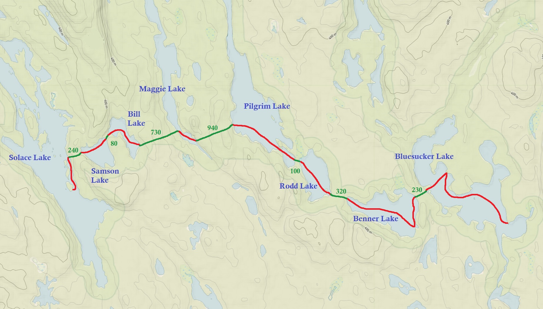
DAY # 6: Solace Lake to Bluesucker Lake (Solace Provincial Park)
Weather: A mix of sun and clouds, rain by the evening. High: 16 C Low: 8C
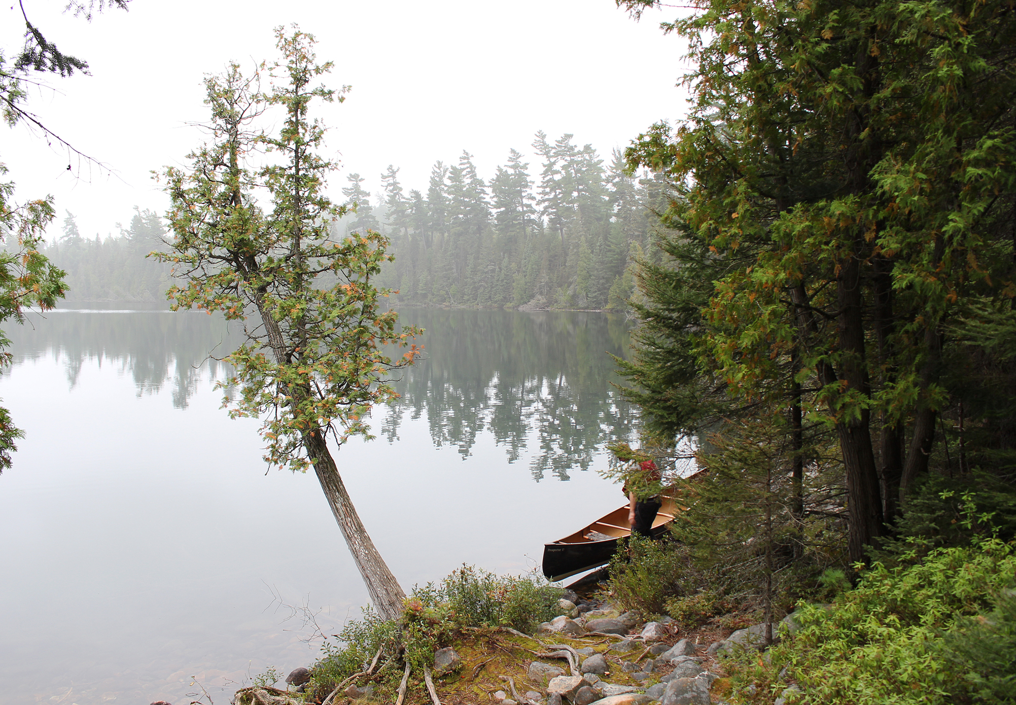
A big bowl of oatmeal and a spot of tea to warm us up was on the breakfast menu as fog enveloped the entire area. Luckily we passed this morning’s portage yesterday, so we were confident enough to paddle the calm waters through the thick fog towards it. It was a slow paddle as it was difficult to observe the rocks that may want to “kiss” the bow of the canoe.

Our first portage of the day was a 240 metre into Samson Lake and this one, along with the 80 metre into Bill Lake, were easy-peesy. It was the next two portages, a 730 metre into Maggie Lake, and the 940 metre into Pilgrim Lake, that were more difficult with steep climbs, and moss covered rocks to negotiate in some sections. We observed a pair of Canada Jays, our only ones on the trip, along the portage to Pilgrim Lake.

Maggie Lake is a long, narrow, and picturesque lake which we thought would be our favourite lake for the day, that is until we hit Pilgrim Lake which was by far the most scenic!

As advertised, Solace Provincial Park is noted for its rugged portages, and this includes the take outs and put ins. The put in after the 100m into Rodd Lake was probably the worse with a lot of boulders. We joked about how different the portages of Temagami are compared to Algonquin Provincial Park. In Algonquin they have board walks over some swampy sections, while in the more heavily traversed areas there are even some docks at the take outs/put ins! None of those luxuries seem to exist out here as you carefully take steps along some portages, and also hope you don’t scratch the canoe too much at take outs/put ins. Sometimes the best spot to put in is where you see painted rocks, the battle scars from different coloured canoes.

After the 320 metre into Benner Lake we saw that the sky was coming blue from the northwest. Marianne read online that the site at the end of the lake was supposed to be decent. On approach the site was anything but, which included some dead pines right over where you would put the tent. Hopefully the rain would hold off for a little longer as we now had to do the 230 metre portage into Bluesucker Lake. It was an easy portage and as usual the first go is with our packs, dropping them off at the put in, then turn around and go back for the canoe, camera bag, and day pack. It was along this portage that we observed some deciduous trees and with them some fall colours. We haven’t encountered any fall colours (let alone leaves) for awhile now as almost every tree has been pine, spruce etc. When getting back to the put in with the canoe and day packs we notice some fresh and rather large mammal scat right beside our backpacks! Good thing we pack our food in plastic bags, which goes in a smell proof bag, which goes into another bag, before it gets into our packs.
We quickly got into the canoe and paddled to the site right across from the portage on Bluesucker Lake to have lunch. It was 2:30 pm by this time and we were hungry! This site was okay but only being mid afternoon we wanted to check out our options so we paddled south. We passed a cottage that was all closed up for the season. This is a very interesting place to see a cottage as we don’t see any ATV trails on our maps. Does that mean they portaged all this stuff in? Paddling towards the southeast end of the lake we noticed quite a few dead Red Pines. We chose the site on the lake’s southeastern shore which had a beach, a seating area around the fire pit, and a good flat spot for the tent. We got the impression that this site would have been epic years ago, but now with some fallen dead Pines, along with dead ones still standing, the area felt kinda spooky for some reason. Maybe the overcast skies also had something to do with this ambiance?

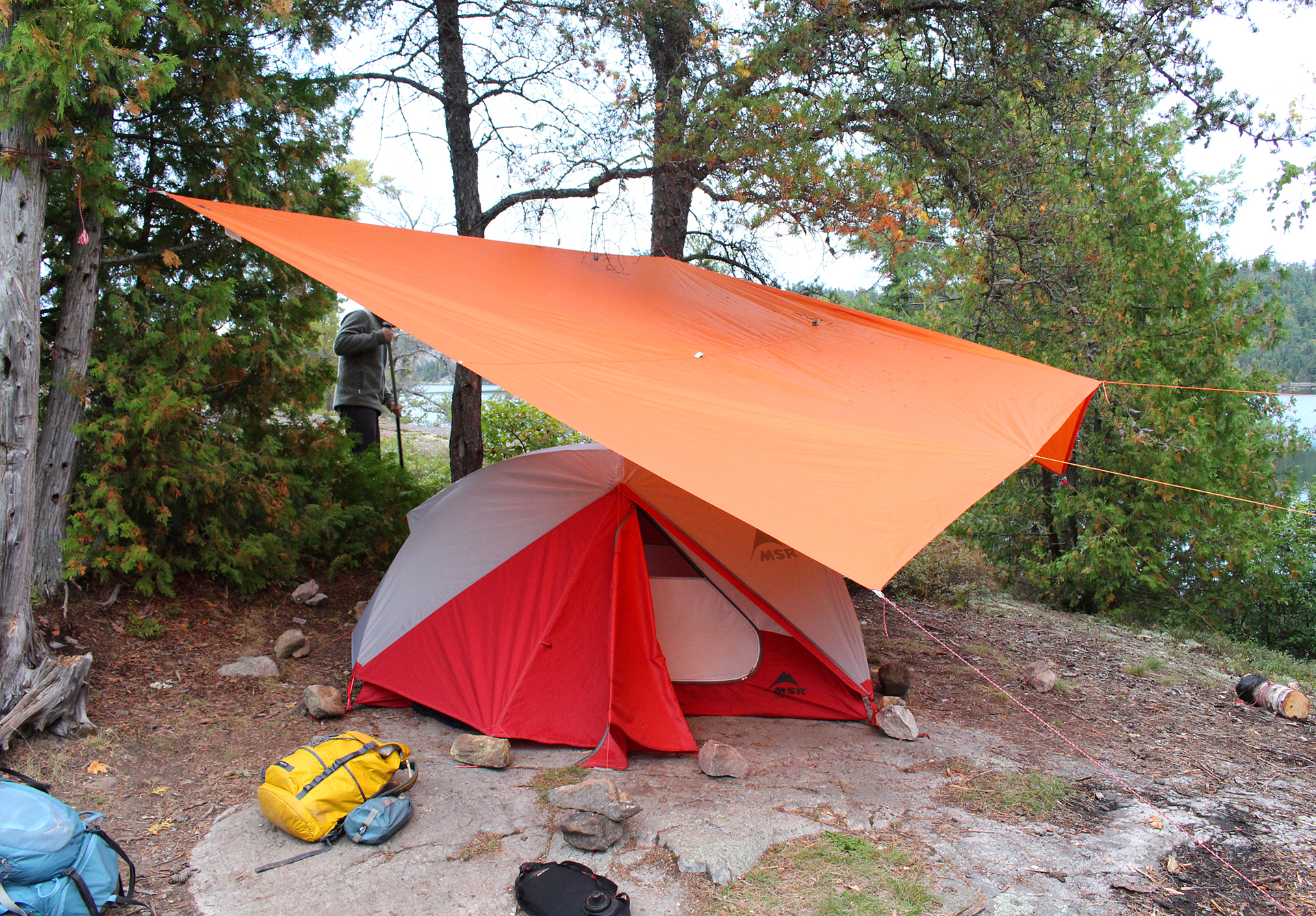
After pumping water we stripped to have a quick “bath” in the lake. The water was cold and we just flailed around like a couple of goof balls. It was shortly after that the forecasted rains arrived and we retreated to the tent. After having such a big day of portaging and paddling we wanted a celebratory pancake dinner over the fire. Now supper was reduced to standing outside with a couple of energy bars and tea while wearing our rain gear…Not quite the same is it? We also decided to put up the tarp, something we actually don’t do too often, and boy do we need more practice! We must’ve modified it three times before we were satisfied. The rain never let up and we played the card game war in the tent until it was lights out after 9pm.

Wildlife Sightings: Common Loon, Black-capped chickadee, Northern Flicker, Red Squirrel, Yellow-bellied Sapsucker, Golden-crowned Kinglet, Canada Goose, Canada Jay, Bald Eagle.
Remember to: Practice tying a tarp more.
DAY # 7: Bluesucker Lake to Florence Lake (Solace Provincial Park to Lady Evelyn Smoothwater Provincial Park)
Weather: Cloudy with a slight breeze. High: 15 C Low: 13C

Our tarp did its job as we woke up to a light mist. We got onto the water under grey skies just after 7:40am. Paddling north we approached a site with the same group of people that we met at Mihell Lake a few days prior. They were just having breakfast and like us, were on their way to Florence Lake for today.
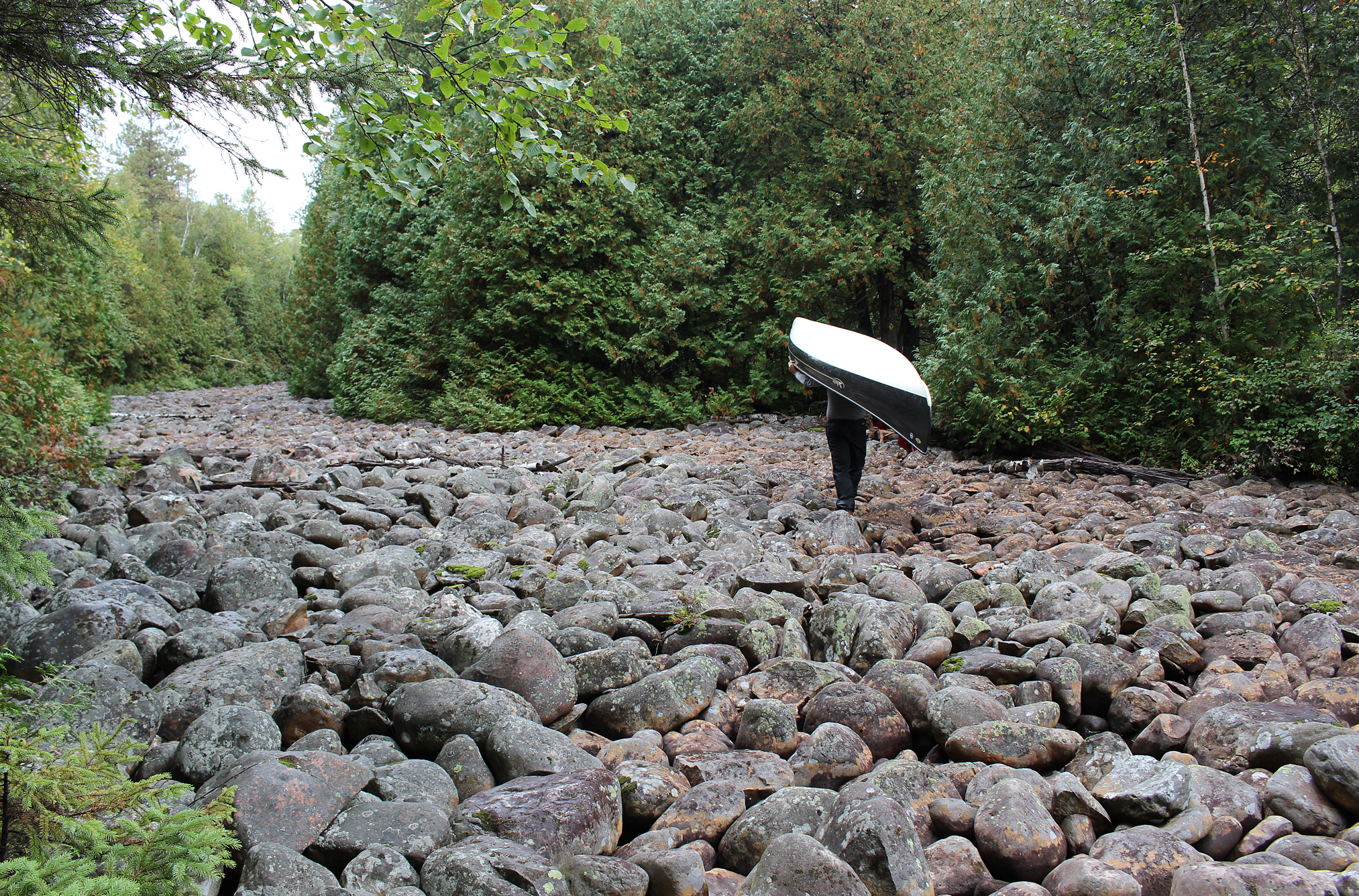
We only had three portages today along with some paddling covering around 10 kilometres in total, though we knew going in that these portages were not run of the mill. At 910 metres our first portage had some elevation to it, but the highlight was definitely the dried up river bed with huge round boulders that we had to cross. With the canoe over his head Aaron went from rock to rock like a Billy Goat, while Marianne was more like a newborn baby giraffe trying to get its footing. You could see some water moving in between the rocks, but it was only a mere trickle. At first we thought that there must be a lot of water that flows during the spring thaw, however looking along the bank of the river there is no sign of a high water line, and undisturbed cedars are clearly growing out and over the sides of the river. The only conclusion we could now perhaps come to is that this river hasn’t flowed in a very very long time. Could this be the remnants of a glacial stream from thousands of years ago? Or perhaps there is a manmade dam somewhere that diverted the water?
The view at the end of this portage was very scenic, though the put in was rocky and very tricky. We soon found ourselves paddling a creek that felt like you were in a narrow valley as rock rose up on both sides. Our next take out was at a very sturdy beaver dam at a 210 metre portage. This portage had some scenic sections with some small falls including one that had a natural jacuzzi to it.
After another brief paddle things got real at the 1,470 metre portage to Florence Lake. This portage threw everything at us! Steep sections, slippery rocks, and a bog where we really had to watch our footing as not to get knee deep in sucking muck. By this time the group we talked to earlier caught up to us for their first carry as we were coming back for the canoe.
All this toil is definitely worth the struggle because after paddling a few more shallow sections the lake opens up and we finally arrived at Florence Lake, and wow what a lake! It’s a fairly large lake with islands, beautiful rolling hills, and escarpments that include some old growth. Unfortunately it was a bit breezy today so no photos were taken as we paddled from the south end of the lake (the most scenic section) to where we ended up near its north end. We did stop for a few photos at a sand bar while we stretched our legs and went exploring.
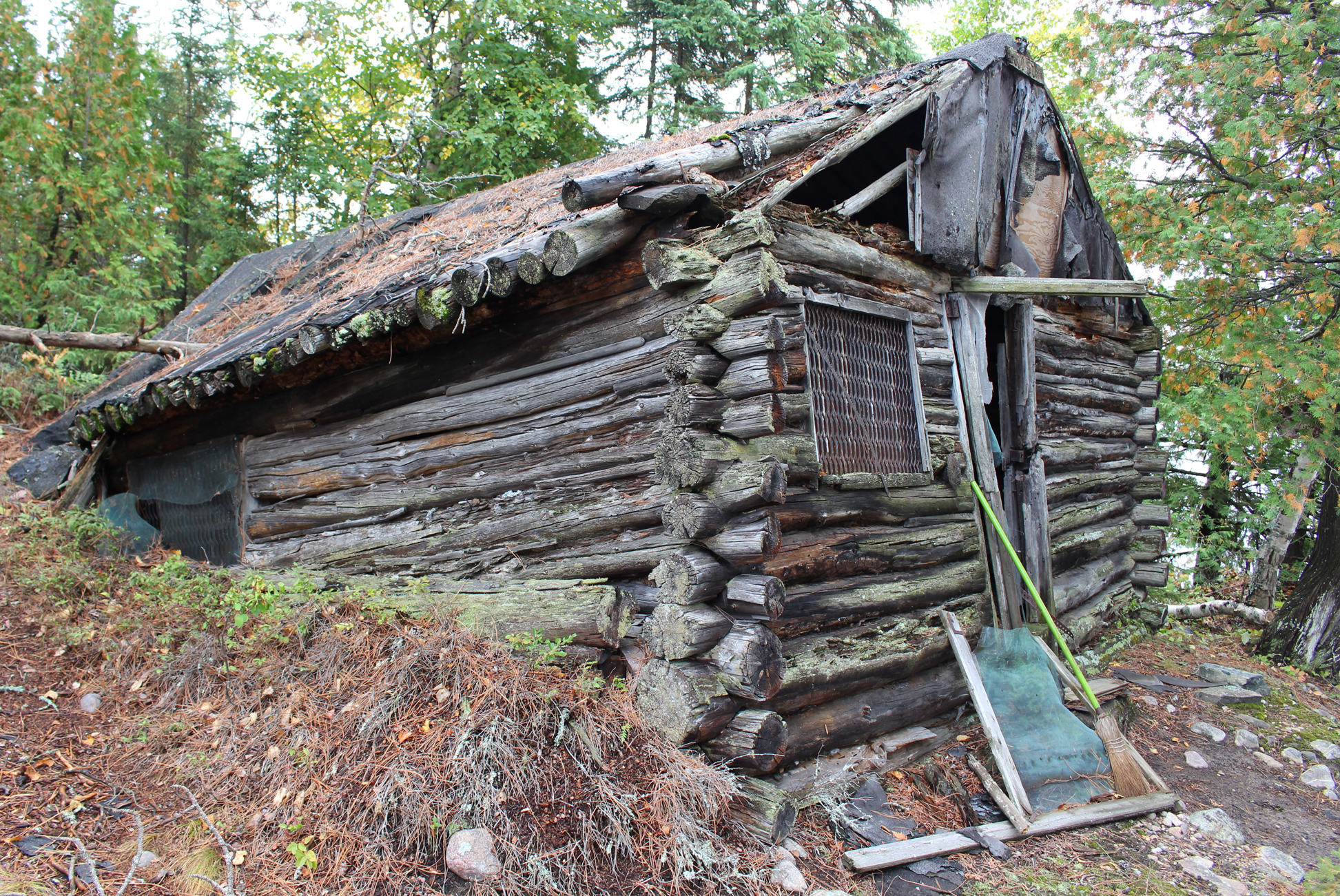
The sand bar is also the location of where some people decided to build a cabin back in the mid 1950s. The roof has since fallen in, but you can tell that this was once a well-built structure. There is even a name inscribed on it, “The Good Tent”, as posted above the door.

We decided to stay at the site at the northeastern end of Florence Lake. It’s a pretty nice site with an okay take in/put out, a few flat spots for a tent, and a lackluster seating area at the firepit. The best part of the site was the view at a high point from up on a smooth bare rock. As soon as we arrived it was time to put up the tent and tarp. By this point it was almost 3pm so we had a lunch/supper of tomato egg noodle, and a well-deserved camping pancake with peanut butter and jam!
We organized our packs and picked out what food to put in our day pack for tomorrow, as we are going to have a layover day tomorrow. We originally planned to spend the whole day exploring Florence Lake, but we shall see what the forecast has in store for us.
Wildlife Sightings: Common Loon, Black-backed Woodpecker, Spruce Grouse, People, Bald Eagle, Dark-eyed Junco, White-throated Sparrow, Black-capped Chickadee, American Robin, Yellow-rumped Warbler, Mosquito, American Pipit.
Remember to: Marianne tuck your pants into your socks when wearing your rain gear so as not to get the bottom of your pants wet

DAY # 8: Florence Lake (Lady Evelyn Smoothwater Provincial Park)
Weather: Cloudy with fog. Mist in the morning and evening.

A little bit of light rain and fog this morning as we enjoyed a hot tea with breakfast under the tarp/vestibule. The weather band on our windup radio stated 15mm – 25mm of rain was on its way so we were glad to use today as a layover day, though it looks like we won’t be getting out on the lake much. In the early hours of the morning Marianne sat still under the vestibule to observe the local wildlife. A few juncos and White-crowned Sparrows scoured the open ground at our site, while a Red Squirrel with attitude ran right through them just so it could get to what looked like a Jack Pine cone. Aaron spent the morning listening to the radio and reading the SAS Survival Guide, which he seems to do every canoe trip.

In the end the rain held off for most of the day, though a slight breeze and the ever-present fog made for lousy photography, a shame because Florence Lake is absolutely gorgeous! In more ideal conditions we would have spent the day exploring all of Florence Lake, with the scenic view from Florence Mountain being the highlight. In the end we just had to settle for relaxing around our site. This is okay because it gives us more reason to come back to Florence Lake on another canoe trip!
We collected some firewood this afternoon, but it was so damp we had to use our camp stove to get it going. Supper tonight was chili with a side of blue Gatorade. Showers returned tonight and we wondered if we actually missed all the rain that was forecasted. Listening to the weather band on our windup radio the heavy rains were now forecasted for tomorrow. Environment Canada….you’re fired!
All snuggled up in the tent for the night we managed to get a local radio station in and we listened to a live recording of Queen at a concert which was really neat! There were songs we have never heard before, and we learned that Freddy Mercury may have been a huge Elvis fan because he did A LOT of cover songs.
Wildlife Sightings: Common Loon, Common Merganser, Dark-eyed Junco, Red Squirrel, Yellow-rumped warbler, White-crowned Sparrow, Water Pipits, Northern Raven, American Crow.
Remember to: No remember to today! Yeah!
DAY # 9: Florence Lake to Gamble Lake (Lady Evelyn Smoothwater Provincial Park)
Weather: Rain in the morning with cloudy skies for the rest of the day. High: 17 C Low: 15 C

In the middle of the night we heard distant rumbles of thunder in the north which thankfully stayed there. We also heard a Great Blue Heron fly over our site, repeatedly calling as it travelled down the length of the lake. The air was so calm that it was well over a minute before it’s call faded completely into the darkness of the night.
After having breakfast under the tarp, we packed up in the rain and were back on the lake before 8:00 am on our way to the Florence River. It was time to say “so long” to Florence Lake.
Along the Florence River we were on the lookout for moose but we ended up moose-less. A slight breeze met us on Duff Lake, and we stopped off at a site located on its western shore for a quick GORP break. Getting out of the canoe and just standing around in our rain gear we actually felt slightly chilled. As soon as we got back into the canoe and continued to paddle we were warm again. The topography began to change as we now were on the South Lady Evelyn River, and we soon see the Duff Ridge in a veil of fog.

The river narrows as we approached our first set of rapids for the day. Known as the “White Rock Rapids” we managed to run all but one set as it was too shallow, and it had quite the 90 degree turn that we didn’t want to attempt. We pulled off to the side where there were a lot of small loose rocks and portaged over to where it was deep enough to get in again after the rapids.

Thankfully the rain had pretty much ended by this point as we arrived at one of only two portages for the day. The first was an easy 430 metre into Dees Lake go, as was the 1,020 metre out of Dees. While on this portage we crossed over what can only be presumed to be an old logging road, now slowly being reclaimed by the forest.

After the portage out of Dees Lake we entered the North Lady Evelyn River and began to paddle against a light current. Before too long we approached the remains of an old bridge that was removed in 2016. Looking at our map it was part of the same road that we crossed over earlier on the last portage. Continuing up the river we encountered some marshy sections that had some waterfowl, along with a couple of Great Blue Heron. Unfortunately, no moose.

Right before Chance Lake there were some rapids that gives you the option to either wade, run, or portage. Going against the current there was no way to run them as we could actually see an elevation change where the rapids were. Walking on the loose rocks to get around the rapids was a little tricky as they were loose, and there were some deeper water sections we had to pay attention to as well so not to fill our hiking boots.
Before the next set of rapids known as “The Gravel Chutes” Aaron considered we get out and do the portage/road that goes from Chance Lake to Gamble Lake. Marianne assured him that we would have no issues wading while lining the canoe so we got out the rope, tied it to the canoe, and changed from our boots to our close toed sandals. The water was a little chilly and we had no problems.
Still under grey skies we eventually arrived at Gamble Lake. In the distance we could see the Gamble Lake launch and a pickup truck with its occupants relaxing at the lake. Maybe they could smell us coming as we haven’t had a descent bath since the beginning of the trip, because they took off as we paddled towards them.
We got out of the canoe at the Gamble Lake launch to stretch our legs. It’s a descent sized area for parking and also includes a site with a picnic table. We are not fans of camping at access points so we dried off our wet feet, put our boots back on, and paddled over to the site near the western end of the lake.
The area surrounding Gamble Lake is noticeably different than Florence Lake as we now observed more deciduous trees and cedars. Perhaps this area once once logged, or maybe even had a fire at one point?
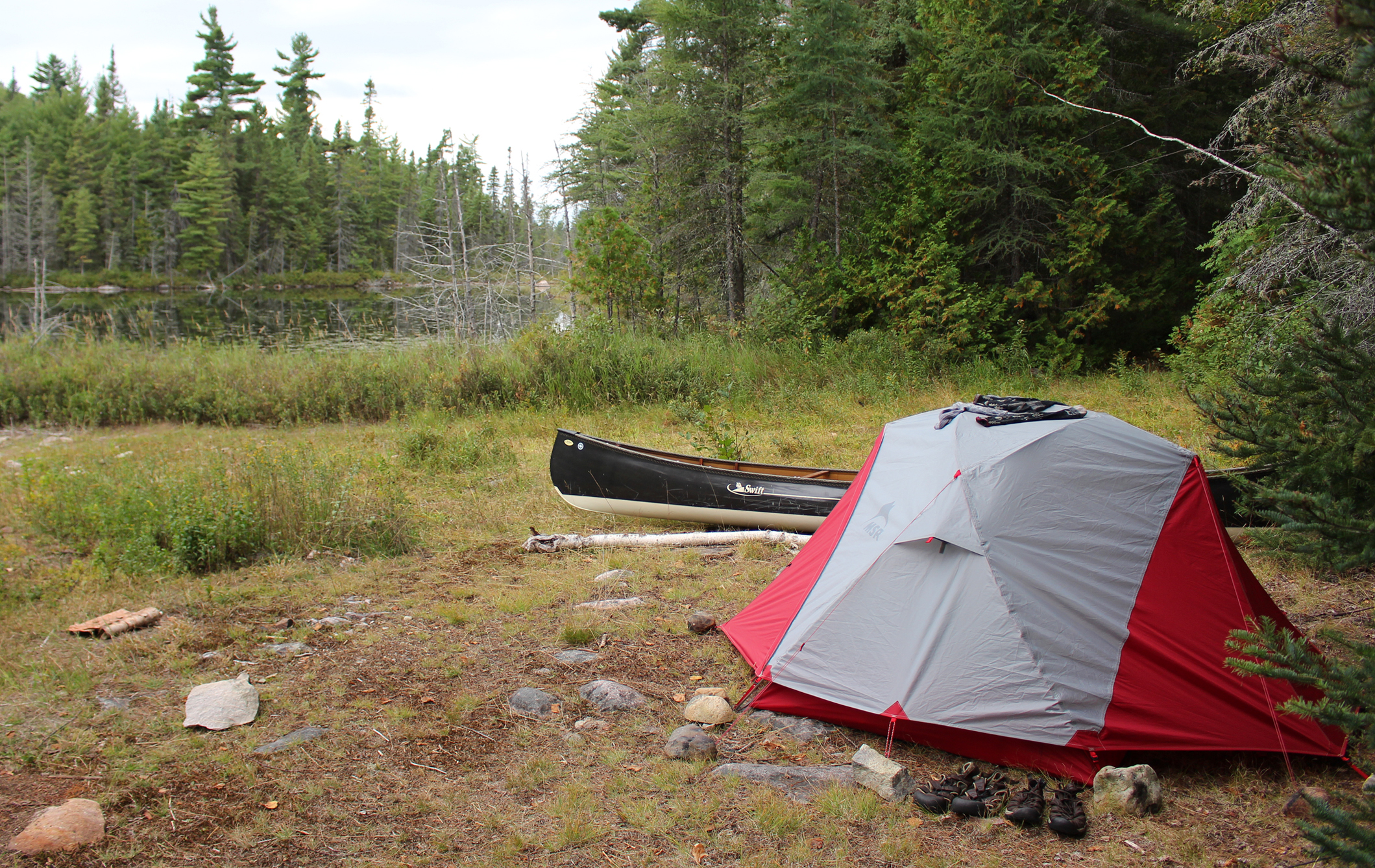
Our campsite on Gamble Lake was a downgrade from our site on Florence Lake as it was a large heavily used campsite with multiple flat spots for a tent with an easy put in/take out. A lot of branches were recently cut and thrown into piles which was kind of strange but not as strange as the overturned thunderbox! Looking down the now exposed deep hole of brown liquid there was no toilet paper which was probably the strangest thing of all! If this site is haunted by a toilet paper eating bear we were too tired to care at this point and we rolled the thunderbox back over the hole. It was then time to put up the tarp and tent in case it decided to rain again. After going out on the lake to pump water we had a quick supper of GORP, our second last fresh apple we’ve been saving, and a hot tea. Making a fire was easy with all these cut branches, and we decided to stay out late tonight and enjoy it!

Wildlife Sightings: Blue Jay, People, Belted Kingfisher, Frog (Mink or Green), Bald Eagle, Herring Gull, Red Squirrel, Common Merganser, Blue Heron, American Pipits, Pileated Woodpecker, Winter Wren, Golden-crowned Kinglet, Black-capped Chickadee, Rusty Blackbird, People.
Remember to: No remember to today. Yeah!
DAY # 10: Gamble Lake to Sunnywater Lake (Lady Evelyn Smoothwater Provincial Park)
Weather: Rain in the morning with clouds and mist by late afternoon. High: 18C Low: 15C.

All the rain that was forecasted a couple of days ago decided to show up last night with thunderstorms and heavy rains that started around 2:30 am, lasting what felt like forever as we eventually fell back asleep when the thunder rumbled every ten minutes instead of every two. We woke up around 6:00 am to the sound of water droplets hitting the tarp from the surrounding trees. As dawn approached we saw that our tarp did a great job as we had no water around the tent! After getting dressed we grabbed our packs from under the flipped over canoe and brought them under the tarp to grab breakfast which was an easy prep of oatmeal. As soon as we were done eating and began to pack up our sleeping bags it began to rain, and then it just poured. The last 8 hours must have seen inches or rain fall. The only thing to do now was lay on our backs, our legs hanging out the opening of the tent, and have a cat nap until the rain stopped.
Around 9:00am the rain stopped and we were back on the water at 10:15am under cloudy skies. (forecast was for sun). After a short paddle we reached the longest portage for the trip at just over 3 kilometres in length.
We honestly can’t remember a more difficult portage than this one! It wasn’t the length that made it hard as we have done long portages before, but rather what the portage threw at us that made it challenging. Honestly if we saw a kitchen sink along the portage we wouldn’t have been surprised! When it was all said and done we never wanted to do it again! Though we did say the same thing about “Heart Attack Hill” in Algonquin Provincial Park, and we’ve done it twice….
The portage starts out routinely enough with your typical rocky sections but soon the surrounding landscape changed completely as we found ourselves out in a very shallow marsh. This wasn’t so bad since all we had to do was watch our step so as not to get a soaker. Aaron decided at this point that maybe we should do this portage in stages instead of all in one go since we have to go back for the canoe each time as we always double over. After returning to the marsh with the canoe we can say that Stage #1: Normal portage plus marsh section is complete!

Right after the marsh we were back on a typical portage consisting of trees and rocks until we came to a wet area that was so wide and deep that we had to drop our packs and go back to grab the canoe. The water over the portage was so deep here that we actually paddled the portage! Stage: 2 Deep water portage/paddle complete!
Getting out of the canoe and putting our packs back on to continue the portage things returned to a little more normalcy with some incline among the rocks and roots, but once again we were confronted with another wet section. This one covered about 100 metres worth of the portage where you literally had to watch every single step so as to not get a soaker. There were some logs put down to walk on but even so Marianne did fill her one boot. We were also in a low spot so we wondered if the water was this high due to last night’s torrential rains? Reaching a higher elevation that was dry we decided to drop off our packs and go back for the canoe, but not before having a quick lunch of GORP, our last apple, and some beef jerky. Coming back with the canoe was interesting and when we approached the water sections Aaron would take the canoe off of his shoulders, place it right side up in the water, and push it across the water, down the portage for about 30 feet. Unfortunately even he couldn’t avoid getting a soaker when he bumped into a tree with the canoe over his head forcing him off balance and going up over his knee in muck. Stage #3: Wet sections complete!
After both getting soakers it was back to more of just trees and rocks for quite some time which was nice. As we continued with just our packs we soon heard the sound of running water. We knew that there was a creek to cross over but when we finally got there it was more like a turbulent stream! The only way to cross without getting the soaker of your life was to hop across, a width of about 4 feet. Even with the pack, Aaron the billygoat had no problem, but Marianne with already both feet soaked didn’t care and just waded across, the water going up to about her knees. After this it was time to drop the packs and go back for the canoe yet again. To get the canoe across the creek, Aaron hopped over the creek and then Marianne would pass him the canoe. Stage #4: Creek crossing complete!
Next it was on to the main event, the 102 metre elevation change for about the last 600 metres of the portage. This section was quite steep, reminding us of other fond memories of portages past such as “Heart Attack Hill”, but at least that portage wasn’t done with soaked hiking boots feeling like weights on your feet! Dropping our packs off at the end of the portage we turned around and walked downhill back to the canoe, followed by the uphill climb yet again. Finally we completed Stage #5: The hill climb, as we got our packs, the 17 foot long canoe, and our sweaty asses to the very end of this monstrous portage! It took us four and a half hours and we were so happy it was done!

We were now at Junction Lake, a tiny lake which was kind of a pain in the butt because it probably took us longer to get all our stuff in and out of the canoe than the actual time it took to paddle to the next portage at 220 metres. Of course why do this once when you can do this twice as we crossed yet another tiny lake for another portage at 380 metres. Luckily these two portages were a lot more “humane”. Reaching the end of the 380 metre portage we spotted a site that wasn’t marked on any map. We seriously contemplated staying here, that is until Marianne saw the dead birch tree precariously still standing above the only flat spot for a tent, with some chunks that have already fallen. It was only 4:00pm in the afternoon so we still had time to paddle the length of Sunnywater Lake to see if the one site on the entire lake was occupied. We entered Sunnywater Lake with a slight breeze along with an annoying misty precipitation.
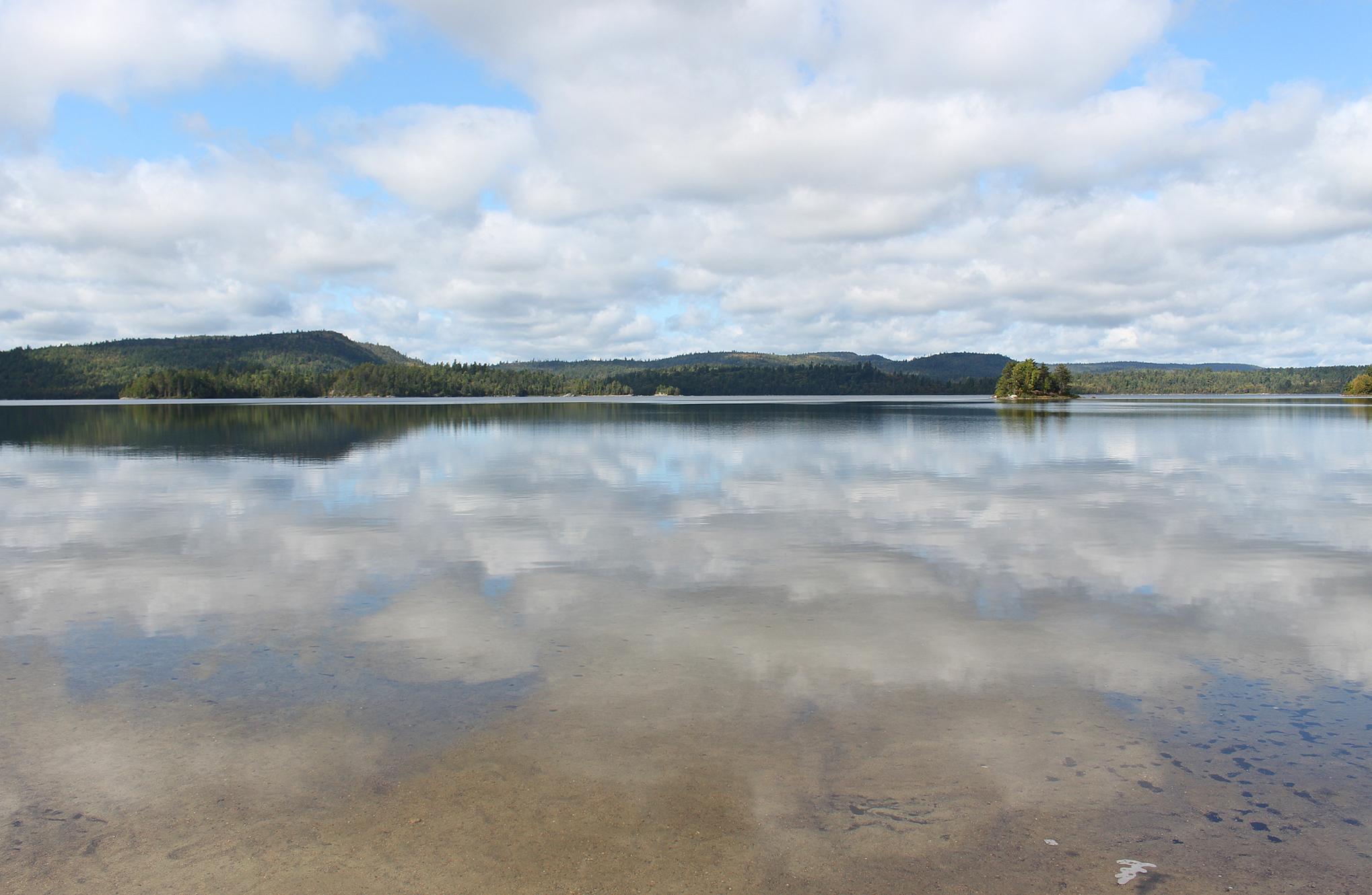
With Junction Lake to the east, and Wilderness Lake to the west, we were now at the highest elevation of canoe travel in all of Temagami. Sunnywater Lake is definitely the clearest lake that we have ever seen in Temagami, easily as clear as Nellie Lake in Killarney Provincial Park where you can see almost 30 feet down to the bottom. Unfortunately the cloudy and misty rain didn’t allow us clear views of the bottom, though the lake was a deep blue as if someone poured in a bottle of Windex. Around 5:30 pm we rounded a corner to discover that the only site was thankfully not occupied, and we quickly got everything out of the canoe, put up the tarp and tent, and went inside to change into dryer clothes (and dry socks!) to warm up!

We pumped water along the shoreline during the last few hours of daylight. We really wanted a bath as we smell pretty bad, but the misty rain and cool breeze discouraged us. Unfazed by the weather, a Moose (probably a cow) called not too far away from our site. Definitely a good night to snuggle with someone to stay warm.
Besides being damp, our site had a great take out/put in, though the firepit and seating area was extremely exposed being right at the lake on a smooth rock. There are multiple flat spots for a tent, while the thunderbox was a fair distance away. Supper tonight was another Backpackers Pantry Pad Thai which we obviously made on our camp stove, as having a fire was completely out of the question. While having supper in the dark under the tarp, Marianne shined her headlamp on a young Spotted Salamander which was about the length of her pinky finger. Completely undeterred by our presence we wondered if we were the first humans it has ever encountered. Maybe we will be the only humans it will ever see in its lifetime!
We had a heck of a day today and went to bed with the sound of water droplets hitting the tarp, a nice white noise instead of having dead silence when trying to fall asleep in the backcountry. We have more portaging tomorrow as we slowly make our way back to Smoothwater Lake with its lovely beaches. We REALLY hope to take a good jump in the lake there!
Wildlife Sightings: American Crow, Golden-crowned Kinglet, Common Loon, Common Merganser, Red Squirrel, Belted Kingfisher, Wood Duck, Spotted Salamander, Moose, Rusty blackbird.
Remember to: Never do the 3Km portage from Gamble Lake to Junction Lake again!
DAY # 11: Sunnywater Lake to Montreal River Access (Lady Evelyn Smoothwater to Crownland)
Weather: Cloudy in the morning with mainly sunny skies by the afternoon. High: 16 C Low: 13 C

With forecasted rains and thunderstorms for tomorrow we decided to forego staying one more night on Smoothwater Lake, choosing instead to reluctantly head back to the launch and the car. This would cut our trip by only half a day which isn’t so bad.
While having cold cereal under the tarp in the predawn hour we were serenaded by our moose again. The annoying misty precipitation returned while we were packing everything up and we were on the water again before 8:00 am under cloudy skies. Approaching the portage we could easily see the bottom of this acidic lake which was both neat and eerie.

Our first portage of the day was a short up and down of 270 metres that brought us to Wilderness Lake. After a very short paddle we arrived at the 1,050 metre portage to Whitepine Lake. While our portage from yesterday included a 100 metre uphill climb, this portage had a 52 metre downhill descent. Though not nearly as rough as yesterday’s portage this one included some technical sections such as portaging along the top of a rocky gulch that had fast moving water passing through. This portage is definitely easier going east to west as the steep section is at the western end and going downhill with the packs is easier than climbing up. What’s also nice is that our packs were a lot lighter now as most of our food is gone. Thankfully this portage, plus the long one from yesterday was towards the END of our trip! It would have been a lot more difficult if they were our first portages for the trip, especially with full packs! This is why we planned this loop to go counterclockwise right from the start. What we didn’t plan for was how bad we smelled right now. Man do we stink!
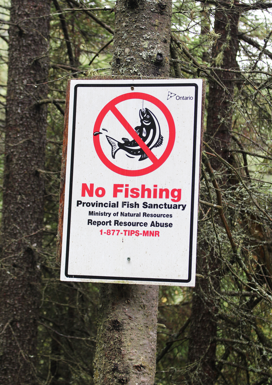
At the end of the portage to Whitepine Lake we see a No Fishing sign. This lake is the home of a rare form (or even subspecies) of Brook Trout known as the Aurora Trout. This pretty fish, which is dark olive green on top with a rosy-orange belly, was “discovered” in the 1920s at one of these high elevation lakes. Whether it is a subspecies or not, this may be one of the rarest, if not THE rarest fish in Ontario. Perhaps never really abundant to begin with, numbers were drastically reduced due to acid rain from smelting emissions in neighbouring Sudbury around the middle of the 20th century. For the backcountry canoeist that has visited Killarney Provincial Park, the sight of these crystal-clear dead lakes with no vegetation, and therefore no life, are a common site thanks to a combination of both acid rain and a topography of inert rock such as quartzite. A drop in pH means no food for fish and the Aurora Trout of Temagami was thought to be extirpated. Thankfully, back in 1958, 3 females and 6 males were collected for a local hatchery, and the species was brought back from the brink. But how do you reintroduce a species of fish in lakes with a pH that can no longer sustain them? In 1989, powdered calcite was added in both Whitepine and neighbouring Whirlygig Lake to raise the pH for the hatchery stock of Aurora Trout that were reintroduced beginning the following year. Over the years there have been a few other lakes in Northeastern Ontario that have also been (and continue to be) restocked with Aurora Trout, but to date it seems that only Whitepine and Whirlygig Lake holds the world’s only self-sustaining population. Thanks to emissions regulations, the fact that these two lakes are quite isolated to begin with, and being located within a provincial park, hopefully this continues to be a successful fish story!
After a very short paddle we arrived at our second last portage for the day, a 660 metre into Marina Lake. One last paddle and we arrived at the portage campsite we were at 11 days ago on Smoothwater Lake and there was nobody there! YEAH!
Smoothwater Lake was like glass and we stripped down on the sandy beach and went in the lake to bath, which felt absolutely amazing!! Changing into drier clean clothes, we made a lunch of Mac n Cheese with tuna at the picnic table, and for dessert we had Backpackers Pantry Creme Brulee. Yum!
By this point the sun came out and it felt so good on your face! We didn’t want to leave such a beautiful site but we weren’t up to paddling in north winds, rain, and potential thunderstorms tomorrow, so we reluctantly packed up and began to head out under warm sunny skies.
We soon paddled out of Smoothwater Lake and we were on the Montreal River heading north back to the launch. We observed the Donovan Fire Tower way off in the distance on a hill to the west, and we met a couple out trolling for fish. After a warm lazy paddle we made it back to the car around 3:30 pm with only one other vehicle besides ours parked at the launch. A few ATVS go by as we loaded the canoe onto the car. Our stinky boots were thrown into the back seat and it doesn’t take long to smell them. Luckily there were no mice in our car this time. On our last trip here we returned back to this launch to find that mice moved in and it was kind of a mess! This time we had toilet paper in a container, no food wrappers, and even a couple of live mouse traps with an arrowroot cookie place inside. Checking out the two traps we saw that one cookie was partially chewed while the other one was gone! Oh well, I guess it saved us the time to dispose of mice.
Driving back down Beauty Lake Road we intended to stay in Timiskaming Shores for the night but everything was booked so we had to go as far as North Bay. We spent the last few days of our vacation in cottage country checking out shops, going out to dinner, and arrived home just in time to come down with Covid-19 right before going back to work that Monday. At least we didn’t catch it BEFORE going into the bush!
This was by far our most difficult, and perhaps one of the more rewarding canoe trips we have ever had! Temagami is definitely more rugged and more isolated than Algonquin, Killarney, and maybe even Quetico? If it wasn’t for running into that one group a few times, plus others near/at access points, we wouldn’t have seen another soul for the whole duration of our trip!
We will definitely be returning to Temagami, maybe even as soon as next year, as there is so much more to explore here in the heart of canoe country in Ontario!
Wildlife sightings: Moose, Blue Jay, Ruffed Grouse, People, Black-throated Blue Warbler, Dark-eyed Junco, Herring Gull, Blue Heron, Common Loon, Red Squirrel, Black-capped Chickadee, Pileated Woodpecker, Downy Woodpecker, White-throated Sparrow.
Remember to: Update our backcountry list at home to “a minimum of 10 aqua tabs per day for water purification.”

Click The Link For More Trip Reports:
