

In the near north the month of October is a flip of the coin of either pleasant cooler weather, or winter like conditions of sleet and even snow. This can occur in the same week or even within 24 hours if a major cold front comes through.
We were fortunate in the weather department that the week we took off in October was pleasant, and using the family cottage as our base camp we had many day trips that included Algonquin Provincial Park. Here we hiked some trails and paddled on a couple of lakes just off the highway 60 corridor.
On October 18th we slid our canoe into the water from the Canoe Lake launch and went in search of the Mowat Cemetery and the abandoned Omanique sawmill. A few years ago we saw some concrete remains of the sawmill along the shore, plus what remained of a bridge leading over to the former property. Back then we had no idea that through the trees just to the right of us were structural remains. We had to check this out!

There was a bit of a northerly breeze on Canoe Lake, and with only a day pack and not a lot of weight in the canoe, steering was a bit more difficult. We paddled to and along the western shoreline looking for landmarks from info we found online, the main one being a culvert signifying the location of the “road”. This road was once a spur off of the former CPR rail line that used to run from Parry Sound to Arnprior, and in Algonquin Provincial Park the trains made many stops that included the nearby former townsite of Mowat. Unless you know this little bit of history you would have no idea while looking around the lake today that either once existed. Mowat evolved into a town after the Gilmour Lumber Company sawmill was built in 1896, and eventually the town reached a population of over 600 that included a school, hospital, and a lodge just to name a few! However, like many other towns in Ontario that depended on lumber mills and/or rail lines for employment, the population dwindled once those booms busted, and Mowat became another ghost town after the rail line ceased altogether around the middle of the 20th century.

Like many towns, Mowat also had a cemetery and that was our first destination for today. The reason why we are looking for such a morbid place is because the Mowat Cemetery was (and still is?) the resting place of Tom Thomson. Unless you’re a Canadian you’ve probably never heard of the famed painter. He was part of an art movement in Canada in the early 20th century to portray the Canadian landscape with an interesting style that often included thick brushstrokes. Thomson loved Algonquin Provincial Park and some of Canada’s most well known paintings were inspired from this location . (“The Jack Pine”, “The West Wind”). Thomson was probably on his way to becoming a member of The Group of Seven, a circle of men that painted the Canadian wilderness, rural settings, and even the trauma that took place on the front during World War I. Some of the more famous works from The Group of Seven have become part of the Canadian identity, up there with hockey and maple syrup. The reason why Thomson never became a member of this clique of artists was that he met his end on Canoe Lake. His boat and later his body was found after he went missing back in July of 1917.
Thomson was known to be quite skilled at handling a canoe, as well as a good angler and outdoorsmen. With no witnesses of his demise various rumors on how he met his fate on that summer day soon surfaced. The most common (and probably the most reasonable?) was that he had an accident and bumped his head (trauma was found on his head) and drowned. Another rumour claimed that when his body was recovered there was a fishing line wrapped around him. There were also rumors that Tom was sweet on a lady nearby and a jealous man wasn’t having any of it and murdered him! Whatever the cause of death we may never know, but the story takes a weird turn after his body was recovered.
We located the culvert and paddled towards Canoe Lake’s northwestern shore, the water just deep enough for us to land the canoe. We rolled the canoe over off the road and walked south until we located a path in the grass to which we began the short hike through the woods to the Mowat cemetery, which is appropriately located up on a hill.

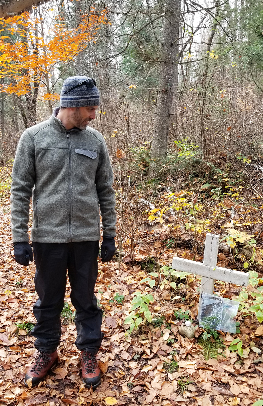
Cemeteries are eerie in general but this tiny cemetery was probably one of the eeriest places we have ever been! There is a white picket fence around it (not the original), and a few head stones. An old birch grows in the cemetery, its sprawling branches made it look like we were on the set of some macabre movie directed by Tim Burton. To add to the ambience were the recently fallen leaves and bare branches, amplifying the white of the birch and the picket fence. Lying just outside of the picket fence is a distinct white cross. This is where Tom Thomson was originally buried a few days after his body was found on Canoe Lake. But is he still here?


After his body was recovered Tom Thomson was buried at the Mowat Cemetery and that is an undisputed fact. What is also a fact is that his family wanted him exhumed and brought to a family plot in Leith, Ontario. This is where the story gets really weird as there is conflicting evidence whether this was actually done, or if his family received an empty casket (or one full of dirt/rocks)? There was word that the undertaker didn’t dig up Thomson as some of the locals from Mowat claimed the hole was too shallow. Perhaps the biggest twist to this mystery was when a group of men dug up a skull in 1956 in Thomson’s supposedly empty grave. The skull appeared to have the same injury that Thomson had. The skull was reburied but only after it was taken in for analysis that “proved” it was not Thomson but the skull of a native, though former townspeople of Mowat claim that they never buried a native there. After this incident the mystery of Tom Thomson, both in his death and where he is buried, became one of Canadian lore, and as the years ticked by it was later almost forgotten by the general public. That is until a few years back when a facial reconstruction by a forensic artist recreated an image that looked nearly identical to Canada’s most famous artist! The forensic artist was said to have no knowledge whose skull it was when they were given photos of the very skull that was unearthed back in 1956. There are videos online of this step by step process which is quite interesting in itself, and the finished product of whose face it is……you be the judge.
What you wish and want to believe around this mystery is up for you to decide, but here we were now at the white cross and final resting place where someone was buried almost 100 years ago. Next to the white cross in a resealable bag was a book called “Canoe Lake Memories” which we didn’t open.
After a few walks around the cemetery we hiked back to the canoe for a quick lunch of a homemade dehyde that we had left over from our trip back in September. We actually saw a vehicle start to come down the road but it ended up turning around.

Back in the canoe and paddling north we searched for our next stop, the remains of the Omanique Lumber mill. Along the shoreline we soon observed some concrete, the foundation of the original sawdust burner. We pulled the canoe up onto the shore and walked into the bush. It didn’t take long and there were the remains right in front of us!


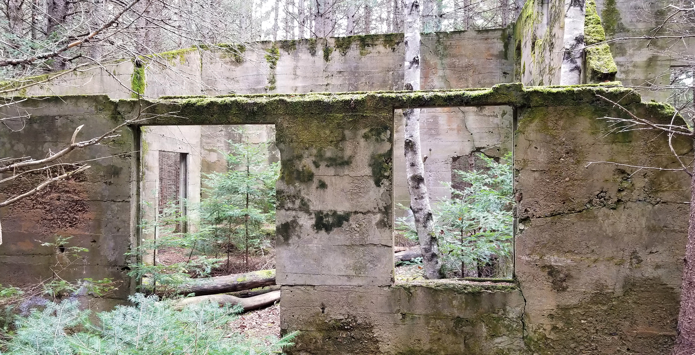

Back in 1926 the Canoe Lake Lumber Company arrived, taking over the former Gilmour lumbering rights, and built the sawmill at the end of Potter Creek. Unfortunately for the Canoe Lake Lumber Company, hauling hardwood logs from Tea Lake and Smoke Lake up to Canoe Lake didn’t work out the way they planned, and the site was abandoned a few years later. A man by the name of Joe Omanique then bought the rights in 1939 and operations resumed. Joe also built a road extension out to highway 60, and a wooden trestle bridge which partially remains to this day just to the northeast of the mill site. Not sure how long the mill was in operation for but it sounds like at least into the 1940s. It would have been something to see a bunch of logs floating on the Canoe Lake, though the noise from a mill may be a little less inviting. Wonder what the locals who had cottages on the lake thought of having a sawmill as a neighbour? Our guess is no one cried when they left.

Aaron had the idea earlier to bring the tarp to make a sail. We had some headwinds on our way over so maybe we could use a sail for an easy paddle back. Unfortunately the winds shifted and our sail wasn’t working. We did meet another paddler on the lake, one that was heading north into the head winds. It was actually nice to be the ones with a tail wind for once!

A few days later we headed back to Algonquin Park, and with the canoe on the car we went to Rock Lake. You can get an incredible view of the lake from the Booth’s Rock Trail, and the Rock Lake campground is located here has well. We launched from the Rock Lake launch site at the Madawaska River and paddled by the quiet and now closed for the season campground. Shortly there after we saw something bright orange along the shoreline. It was a soccer ball! We paddled up to it and saw that it was still inflated so we threw it into the canoe to take home as a souvenir.
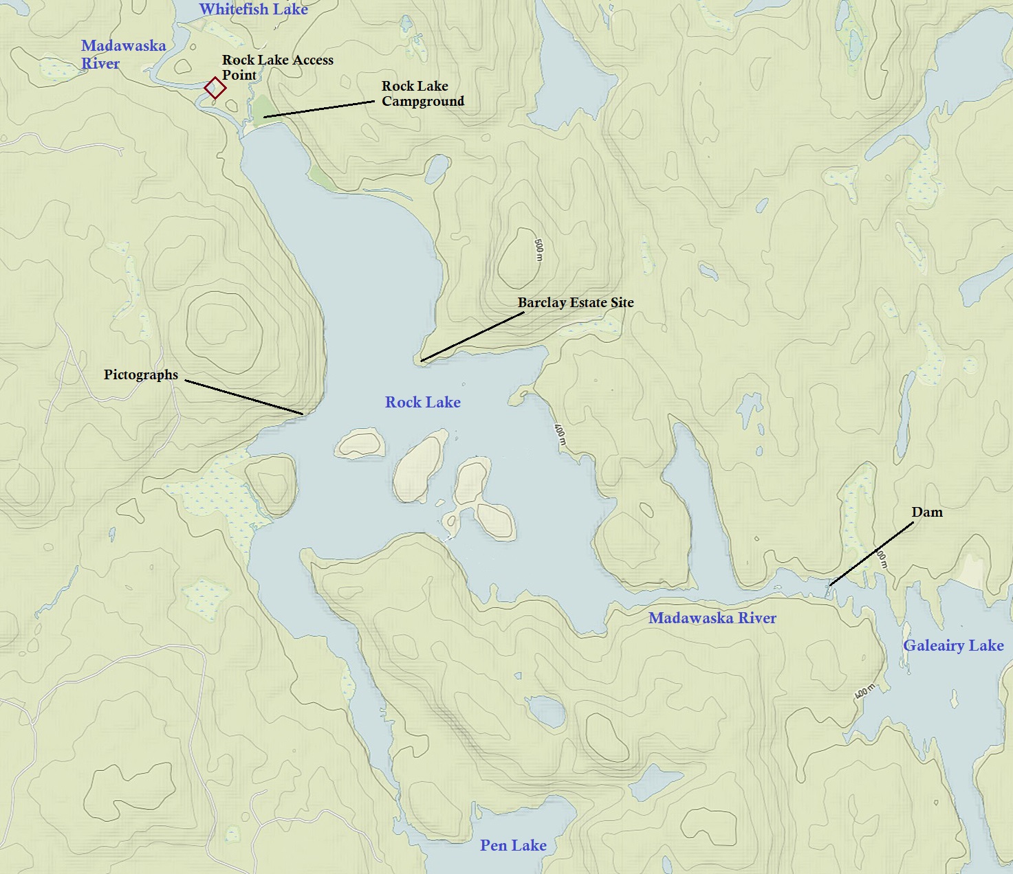
The Rock Lake Campground was once part of Rock Lake Station, a stop along the the former Ottaway, Arnprior and Parry Sound Railway. Operating from the late 1890s until it’s demise with only sections running into the late 1950s, this railway was once one of the busiest in all of Canada! Hauling timber, grain, tourists, and even troops during the first world war. It was built from the entrepreneur vision of a lumber baron by the name of John Rudolphus Booth, who had a lot of timber rights in central Ontario, along with one of the world’s largest sawmill operations in Ottawa. Booth initially built the railroad as an easier means of transportation to haul his lumber. If you hike the Booth’s Rock Trail, or paddle past the campground while hugging Rock Lake’s eastern shore, you will see where the railroad once was, along with some foundations and remains of a dock/boathouse. These are some of the remains of the George Barclay estate, a relative of Booths. The estate, built at some point around the the turn of the 20th century, eventually had a boat house, gardens, and even a stable! The property was sold back to the government in 1953, and demolished in 1957. If you want to see what the property looked like back in it’s heyday, click the following link, followed by the “Photos” tab to search in Algonquin Park Archives: https://algonquinpark.catalogaccess.com/

Rock Lake also has some quaint looking cottages! Some of the nicest ones we have seen thus far on our trips into the Algonquin interior. Many of these cottages, on lease with the park, have been passed down through families for years. There remains an ongoing debate of whether or not the park should just end the leases instead of always extending them. If they ended the leases the cottages would be taken down leaving the park to a more “natural” state. We would like to believe that the lease holders respect and have a connection to the park as much (maybe even more) as those that camp and day trip here.
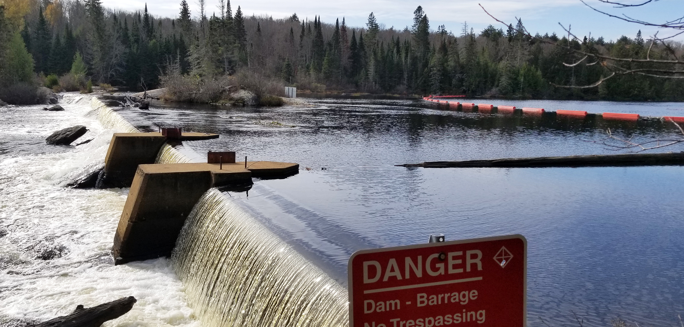
Paddling south we checked out a dam at the southeast end of Rock Lake where the Madawaska River meets Galeairy Lake. There is a 100 metre portage here where we had a break and took some photos of the dam.
Heading back west we paddled to the southern end of Rock Lake and saw some more cute modest looking cottages. We made it to the 380 metre portage that goes to Pen Lake and we went to check out some fast moving water along here. We soon met a group of backcountry campers that were enjoying this beautiful stretch of weather before mother nature remembers that it’s actually mid October, not September.

Paddling north along the western shoreline we located the 2,900 metre portage that takes you to Lake Louisa, and we see the marshy area around Louisa Creek. Glad we didn’t have any long portages today, though we would love to go to Lake Louisa one of these days!
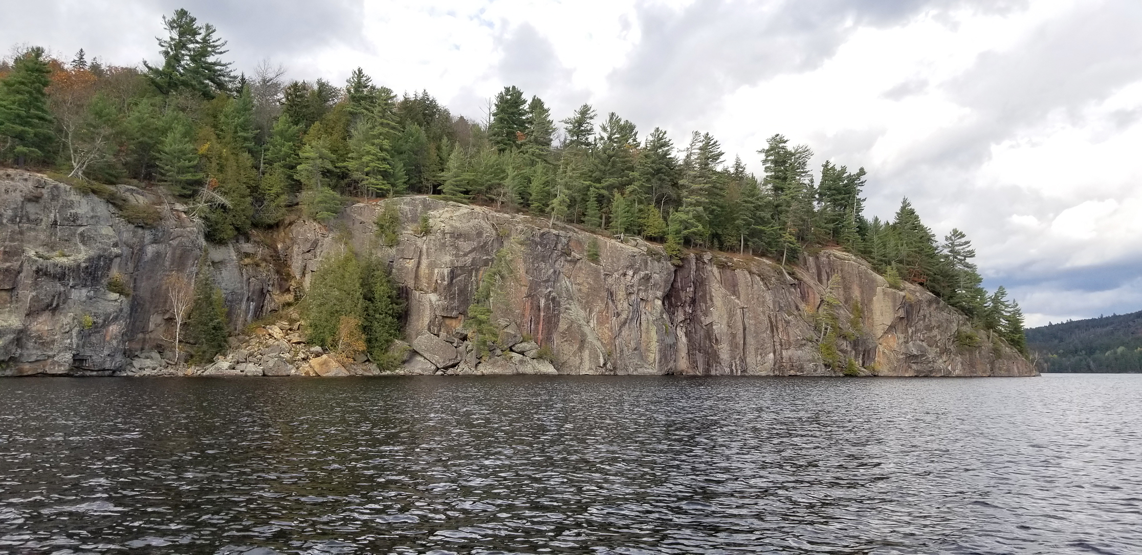
Rock Lake has some pretty impressive cliffs (perhaps it’s namesake?) and along the cliff at the western shoreline is a pictograph. This is the only pictograph we know of in the park. The first image we found were of lines. There is also the image of a figure which could be of a Nanabush, a half human half spirit creature.

By this point in the day the breeze was starting to pick up and the water was beginning to get choppy. Clouds were also coming in and they looked somewhat ominous. Paddling back north we decided to paddle past the launch and go up the Madawaska River to the old rail bridge (now part of the Old Railway Bike Trail) into Whitefish Lake. There are quite a few cottages along this stretch of the river and along the south side of Whitefish Lake. Looking on the map there was once a lumber camp nearby just north of where we currently were on the western shoreline, but it was beginning to get late and we wanted to get back to the cottage before dark, so we foregoed that particular search.

Driving west down Highway 60 we saw quite a few cars pulled over and we pretty much knew right away what was going on. A big male moose was feeding in the shallows of a marsh just off the road, giving photographers and tourists excellent views of this iconic animal of the Canadian wilderness. We didn’t pull over. One being that highway 60 is a major road, and two…..we wanted a shower, some food, and a whiskey!

Click The Link For More Trip Reports: https://backcountrybalkwills.com/
