
Total Days: 10 1/2
Total Kilometres: approx. 240 kilometres
Total Portages: 36
Total Portage Length: approx. 11.00 kilometres
Longest Portage: 1.680 kilometres (Upper Basswood Falls)
Average Daytime High: 15.5 Celsius
Average Nighttime Low: 8.7 Celsius
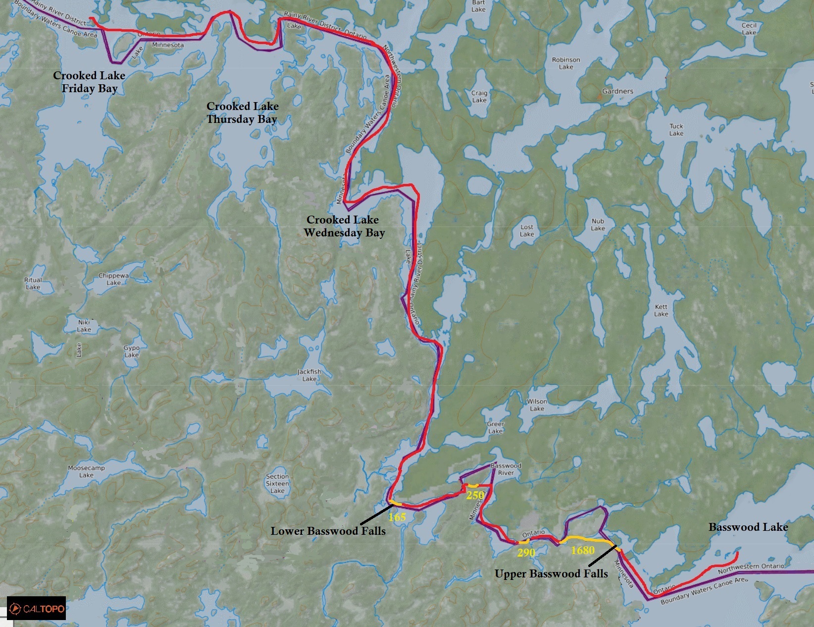
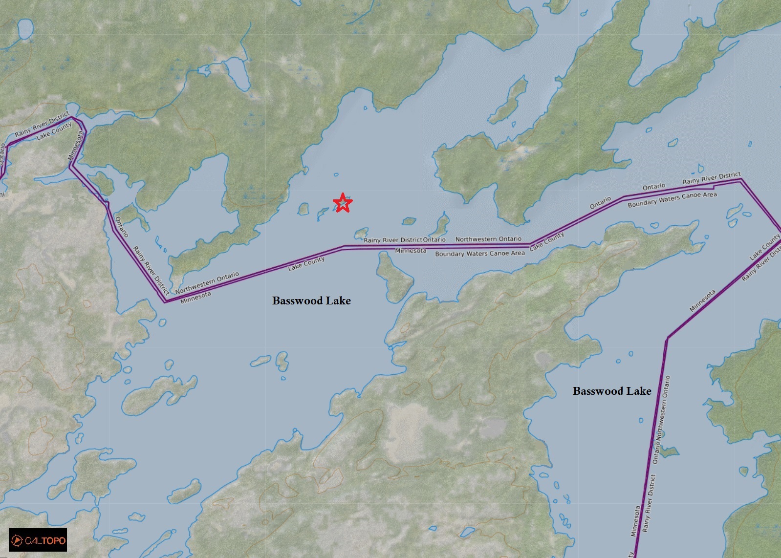
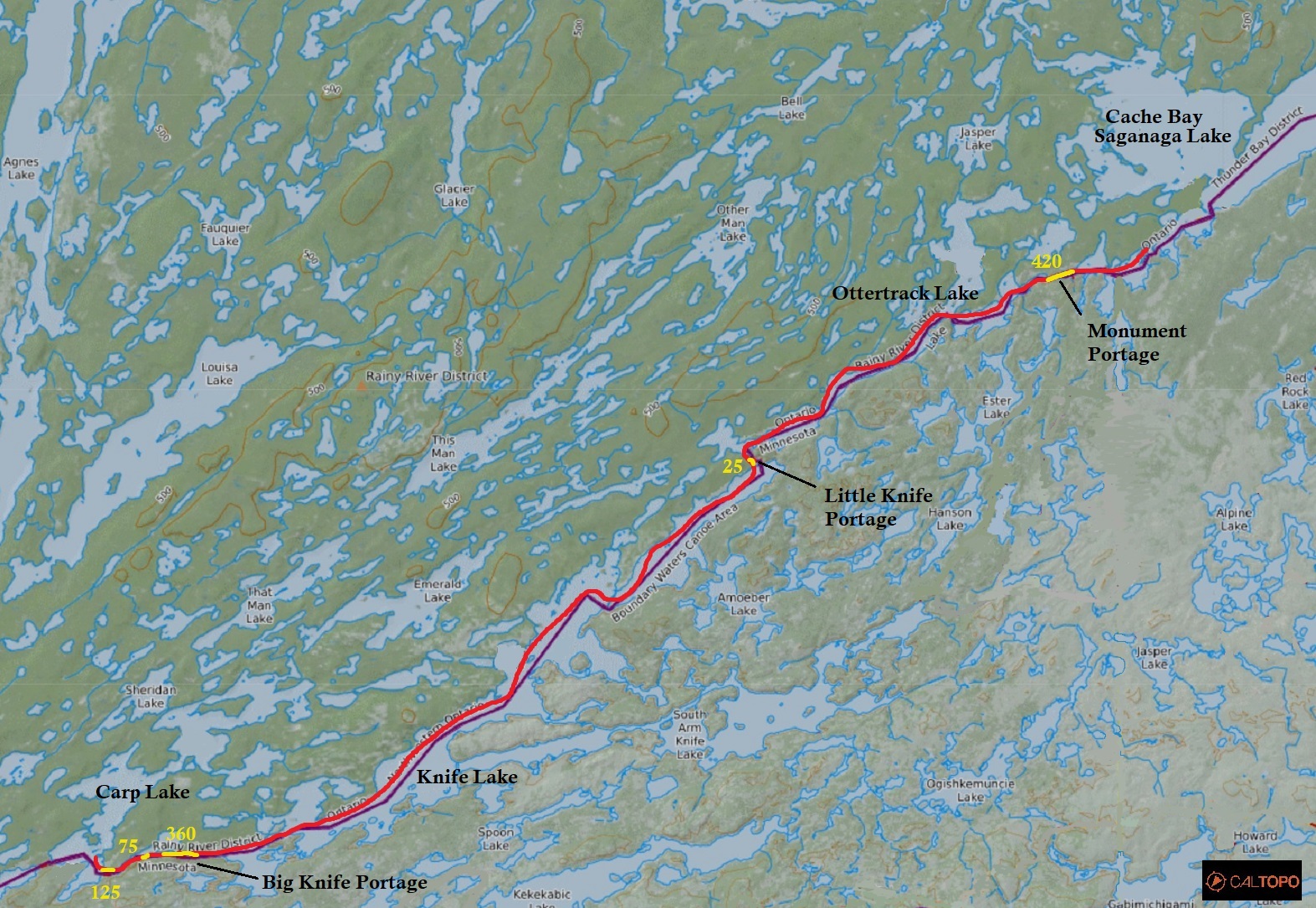
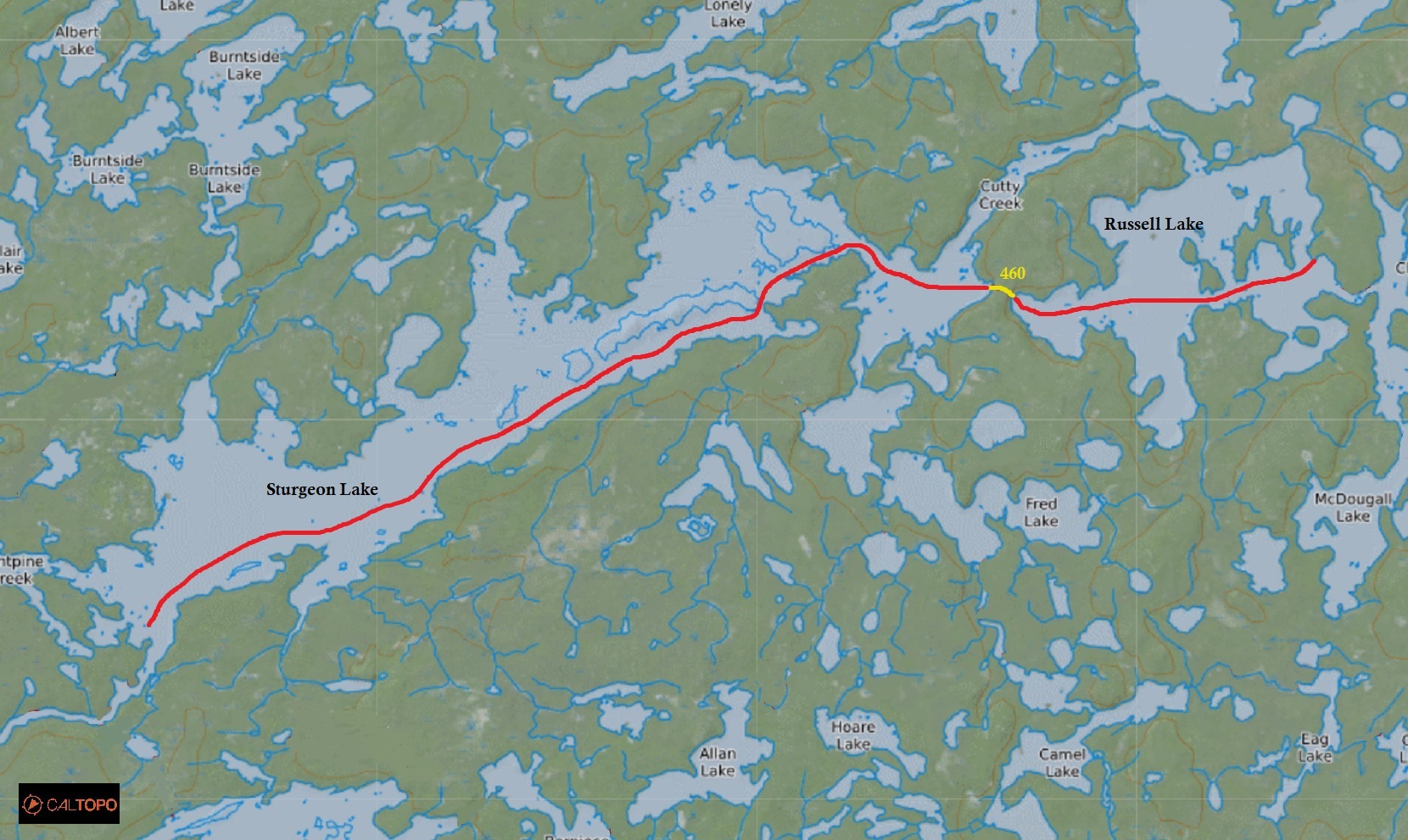
Route: Lac La Croix – Bottle Lake – Iron Lake – Crooked Lake – Basswood River – Basswood Lake – Birch Lake – Carp Lake – Melon Lake – Seed Lake – Knife Lake – Ottertrack Lake – Swamp Lake – Cache Bay – Saganaga Lake – Sagagons Lake – Sidney Lake – Kenny Lake – Atkins Bay – Kawnipi LAke – Shelley Lake – Keats Lake – Chatterton Lake – Russell Lake – Sturgeon Lake – Maligne River – Tanner Lake – Maligne River – Lac La Croix
Maps Used: Chrismar Map Quetico Provincial Park and Area. – Fisher Maps F-23, F-16, F-17, F-10, F-11, F-19, F-26, F-25, F-24. – Detailed maps of the Falls Chain and the Maligne River area from Ontario Parks
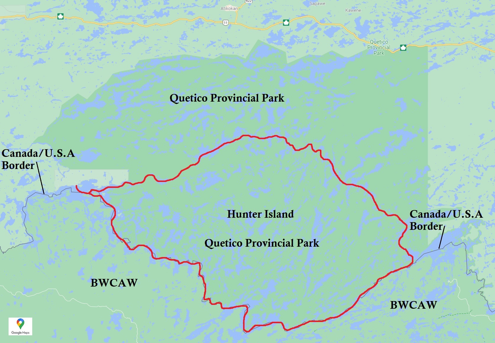
After being owned by Quetico Provincial Park on our last trip, we decided to return with improved gear and more experience in a pretty big way, by attempting to paddle the Hunter Island Loop!
What makes this the ultimate paddling trip in Quetico? At over 200 kilometres in length it takes awhile to paddle this route. Most sources advise 10 to 12 days to complete the route while others quote a more conservative 14 days. Of course it all depends on the weather as the route crosses some of the largest windiest lakes in the park so the chances of a wind bound day does exist. The Hunter Island route also travels through many interesting cultural and natural features including native pictographs on rocks, relics from logging, tracks of land changed by forest fires, and river rapids that may or may not be negotiated.
Once we decided that we wanted to do the Hunter Island loop, it was time to plan. Due to the length of this trip, the fact that Quetico is a wilderness park with no portage or campsite signs, plus the fact that we were not very experienced from our last attempt here, we did a lot of planning and research from various sources of literature, maps, online websites, and forums.
In the end, we found many helpful and essential items to make this trip practically void of pitfalls. Here are a few resources that helped us plan.
1. Chrismar Maps http://www.chrismar.com/
The Chrismar map for Quetico is a single map depicting an overview of the whole park. Portages are shown with most stating the length in metres. Other info includes details of the access points (ranger stations), the Dawson Trail campground, and the town of Atikokan which is where the park’s headquarters is located. The Chrismar map also includes a detail side map of the Falls Chain, a series of waterfalls and rapids which is one of the most treacherous sections of the entire park. On the reverse side of the Chrismar Map is a description of the natural and cultural history, details of the ranger stations, and some suggested routes. The only downside of the Chrismar Map is that it isn’t a topo map, isn’t of appropriate scale for navigation (it’s great for an overview and route planning map) and it doesn’t show the location of campsites or pictographs.
2. Fisher Maps https://www.fishermaps.com/
Fisher Maps has produced a series of maps depicting sections of both Quetico and the surrounding Boundary Waters Canoe Area Wilderness that is just on the other side of the border in Minnesota. The Quetico series of maps illustrate known campsites from a 1979 geological survey, as well as portage lengths in rods. These maps are essential (as are the similar Mackenzie maps) in making navigating a little easier as there are multiple maps you can purchase depending on where your route is in the park. For Quetico Provincial park there are around 20 maps you can purchase if you want to have the whole park set. The one downside of the Fisher Maps is that they lack topographical features, and because these maps were created in the 1970s, portages can and have changed, so comparing this series of maps with the Chrismar Map is a must. We actually bring both sets of maps with us. A nice feature of the Fisher maps as well is that they illustrate where pictographs are located.
3. PaddlePlanner https://www.paddleplanner.com/
This site has online maps that illustrate updated known sites and portages as reported by paddlers. Some of the “sites” that we saw on these online maps we couldn’t even locate a flat piece of land. Many of the known campsites have been rated between 1 to 5 stars and we would mark these sites on our Fisher Map with the ratings right beside them so we could aim for the more primo sites. The site also displays the topography on their maps which is nice.
4. QuietJourney http://www.quietjourney.com/
This website is great in that it covers a lot of info about Quetico and the Boundary Waters. It has a database of a lot of the portages in the park including their length, average time to complete, and difficulty. From this site we found out that a couple of portages on our Fisher Maps were labelled incorrectly (or more likely have just changed since the 1970s). For example, on the Fisher Map there looks like there is a portage right at the top of Chatterton Falls. Quiet Journey lets people know that it is in fact a side trip to see the top of the falls.
5. Ontario Website https://www.ontario.ca/
So you planned your route months ahead and when you arrive you find out that there is a forest fire right where you wanted to go….now what? Luckily the Government of Ontario’s website has a map that illustrates current forest fire locations along with their size in hectares. The MNRF also has an interactive map that labels areas in Ontario that are under low to extreme fire risks. Remember that Quetico is a wilderness park and fires are encouraged to burn to allow natural succession.
6. Boundary Waters Canoe Area https://bwca.com/
The Boundary Waters Canoe Area information resource has a community of people that are eager to share their experiences. From the sites message board we found out that there were some current updates to some portages around the series of rapids along the Maligne River including a new portage that wasn’t on any of our maps. The new portage was put in place during the high and fast moving waters after the spring thaw making the rapids more dangerous. Lucky for us the water levels lowered before our trip, and we easily ran the water where the new portage was put in place during the spring.
7. Ontario Parks https://www.ontarioparks.com/
Calling the staff at Ontario Parks before a trip is always a good idea to find out any last minute information whether it be water levels, problem bears, or closed campsites to name a few. When we phoned before our trip we received updated maps via email of two potentially dangerous sections of our route including the Falls Chain and the Maligne River. The maps detailed exactly where the portages were and what side of the lake to approach/depart from.
Not sure if gathering all this information from multiple sources is overkill, but it sure made our trip easier and more relaxing.
DAY # 1: Lake La Croix to Iron Lake
Weather: Fog in the morning with sunshine for the rest of the day. High: 24 C Low: 10 C

After staying overnight in the lovely town of Atikokan at the Atikokan Hotel (which we highly recommend) we drove west and then turned south onto the 76 kilometre gravel road (Road 901) until we reached the Lac La Croix ranger station/launch at the Lac La Croix First Nations. Here we filled out our self serve permit, while being harassed by mosquitoes when unloading the gear from our car. When we got to the launch we met a group that came in by boat. They were here to register as well and were surprised that we actually came in by car. We were pretty confident that they had no idea there was a road to Lac La Croix.
After we launched we soon found ourselves on the wide expanse of Lac La Croix. There were motor boats on this lake that are mainly used by the Lac La Croix First Nations, but the sound of motorboats don’t bother us at all. The lake was nice and calm and the temperature of the air was almost too warm for us at a balmy 24 degrees Celsius.
Paddling down Lac La Croix we tried to find the pictographs on the eastern shoreline, but for some reason we couldn’t locate them. We also checked out Warrior Hill which was said to have been historically used by indigenous people displaying feats of strength by running up from its base to the very top. And wow it is steep!
It was at this point we realized that our boat bailer that also included our rope, whistle and flashlight were still in the car! Well there is our “remember to” for the day.
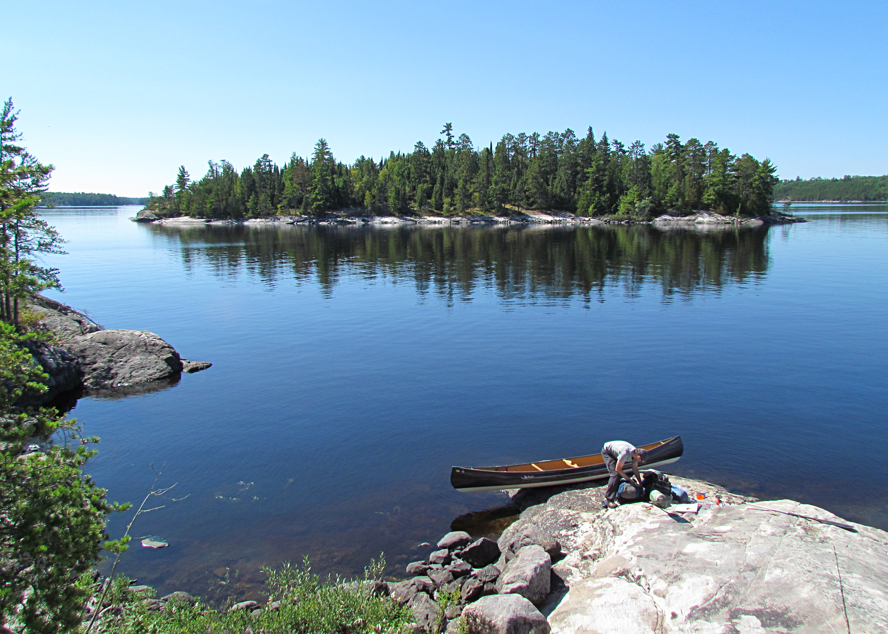
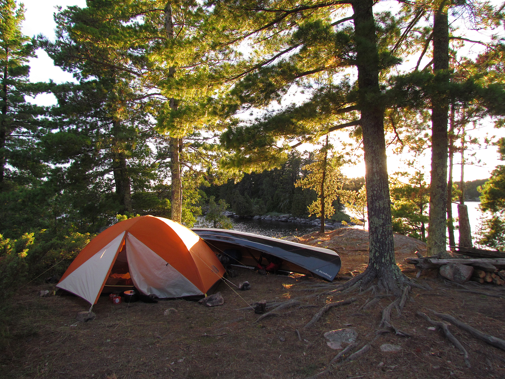
Our first potage of the trip was 510 metres from the southern end of Lac La Croix into Bottle Lake, known as the “Bottle Portage”. From here we paddled into Iron Lake until we arrived at an island campsite where there were a lot less mosquitoes. We took a quick jump into the lake for a bath and relaxed for the rest of the afternoon. A pair of really tame Red Squirrels were at this site as well. Hopefully they stay out of our tent.

Wildlife Sightings: Yellow-rumped Warbler, Spruce Grouse, Ruffed Grouse, Blue Jay, Common Raven, American Crow, Common Loon, Ring-billed Gull, Eastern Chipmunk, Red Squirrel, White-tailed Deer, Black-capped Chickadee, Mosquitoes, People
Remember to: Don’t forget the boat bailer in the car.
DAY # 2: Iron Lake to Crooked Lake (Friday Bay)
Weather: Sunny with 30 kph west winds in the afternoon. High: 24 C Low: 14 C
We woke up to the chattering of our Red Squirrels and began our day with some premade dehydrated breakfast of honey granola with raspberries, along with Twinnings Irish Breakfast Tea which we call our “morale tea”. We were out on the water a little after 8:00 am.
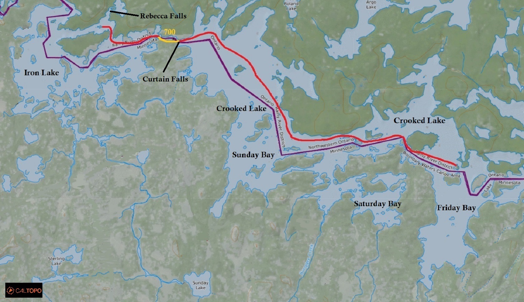
Our first stop was to check out Rebecca Falls which we could just barely hear from our campsite the night before. The water was moving really fast and was quite impressive! Heading east on Iron Lake we navigated and ran a swift to our only portage for the day, a 700 metre that headed east from Iron Lake to Crooked Lake. At the end of the portage was Curtain Falls that was really impressive!

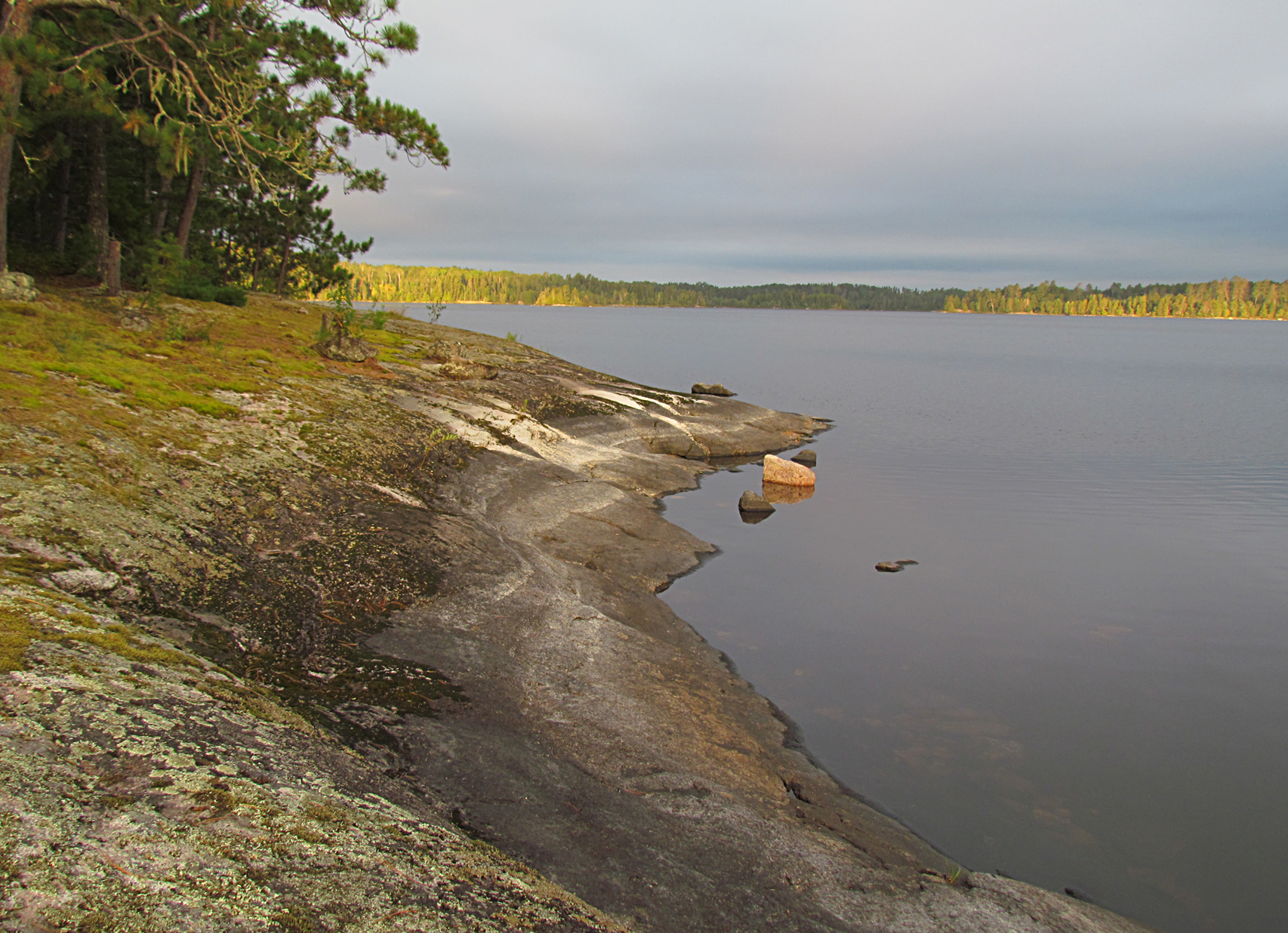
Paddling southeast on Crooked Lake we viewed some very pale pictographs near the western shoreline of Sunday Bay. As the day wore on we were hit head on by wind and some waves. After stopping for lunch on Sunday Bay we had a heck of a time trying to get back into the canoe as the waves banged the canoe against the rocks. Paddling was pretty slow going but once we hit Friday Bay the waves turned into swells with the wind making the canoe uncontrollable. Looking down at our Fisher Map we located a campsite and headed towards an island on the north shore. After unloading the canoe and setting up the tent, we quickly bathed. Before making supper, (homemade chili dehyde and bannock with freeze-dried black bean hummus) Aaron fixed the fire pit.
Wildlife Sightings: Yellow-rumped Warbler, Bald Eagle, Ring-billed Gull, Red Squirrel, Turkey Vulture, Song Sparrow, Common Loon, Black-capped Chickadee, Red-breasted Nuthatch, People
Remember to: Bring a plastic bag for dirty clothes to keep them separated from clean clothes.
DAY # 3: Crooked Lake (Friday Bay) to Basswood Lake
Weather: Cloudy in the morning, showers for the rest of the day. High: 14 C Low: 10 C
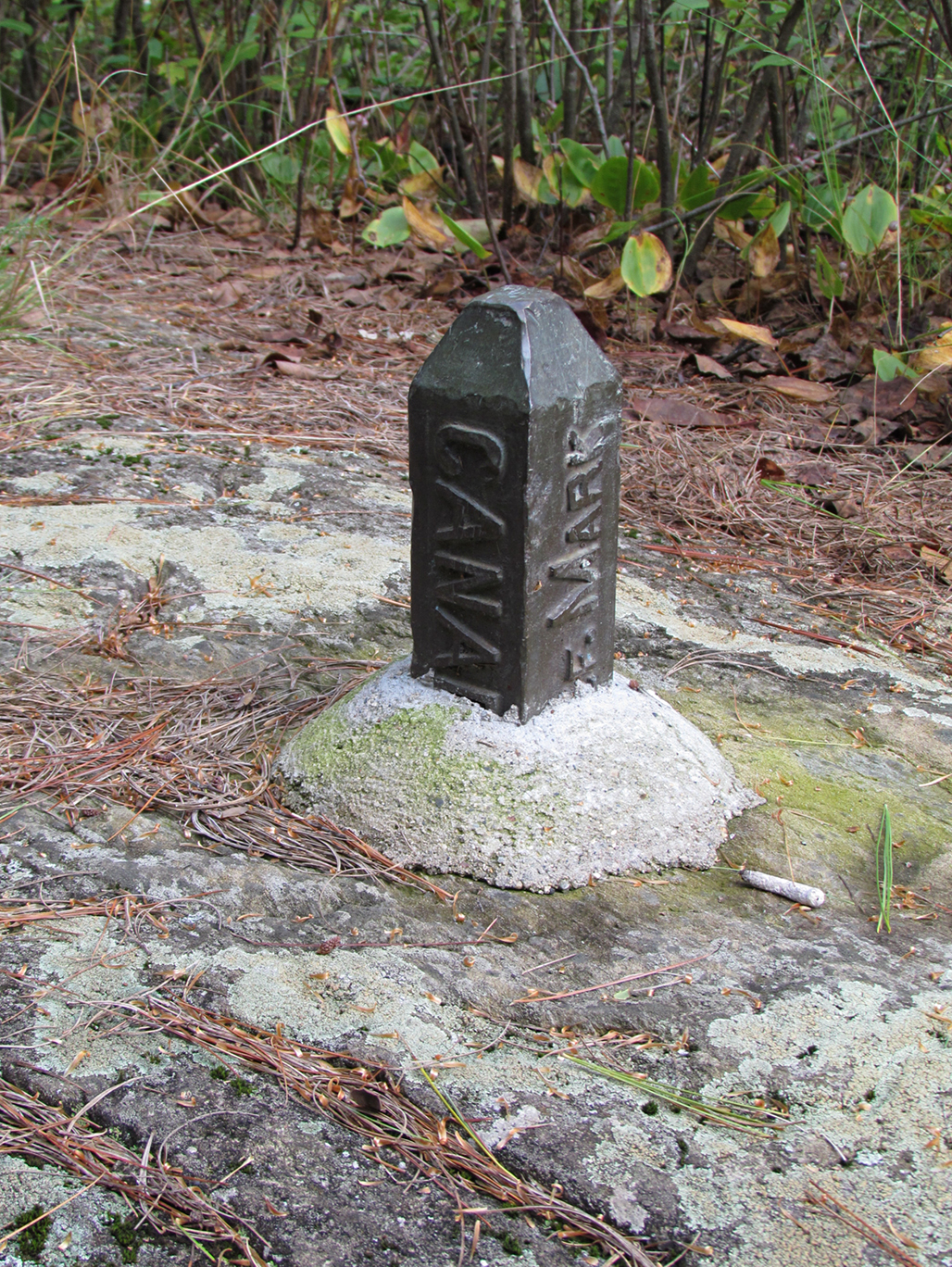
This morning we woke up just after 6:00 am (yes this is vacation). The winds were calm again and we wanted to get a head start on the day. After a quick breakfast of oatmeal we were back on the water by 7:30 am. This morning felt like we were on an entirely different lake as the waves from yesterday were gone. As we headed east into Thursday Bay and then south into Wednesday Bay, the lake narrowed. There were a lot of other canoeists out here with most of them sporting a fishing rod. Most (maybe all?) appeared to be American which was not a surprise as we were paddling right along the Ontario/Minnesota border. What is surprising (or at least to us) is the fact that most of the visitors to Quetico Provincial Park are indeed American citizens. It was along this narrow gap we began to see stakes in the ground along with some rocks that marked the U.S/Canada border.
Along here we viewed some more distinctive pictographs on the south leg of Crooked Lake with images that included a moose, heron and a branch.
As we continued our paddle the sky became more overcast and it felt colder so we put on more layers. We had three more small portages and a long 1,680 metre portage as the last one for the day that would bring us into Basswood Lake. This last portage was also the longest for the whole trip, which is hard to believe as our usual longest portages are over 2,000 metres. It was along this portage we met a gentleman who was soloing from Lake of the Woods to Lake Superior! He was impressed by our route, but we were even more impressed by his route! He had three weeks to complete his trip and he was ahead of schedule with the aid of a sail while the wind was at his back.
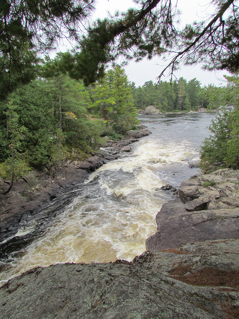
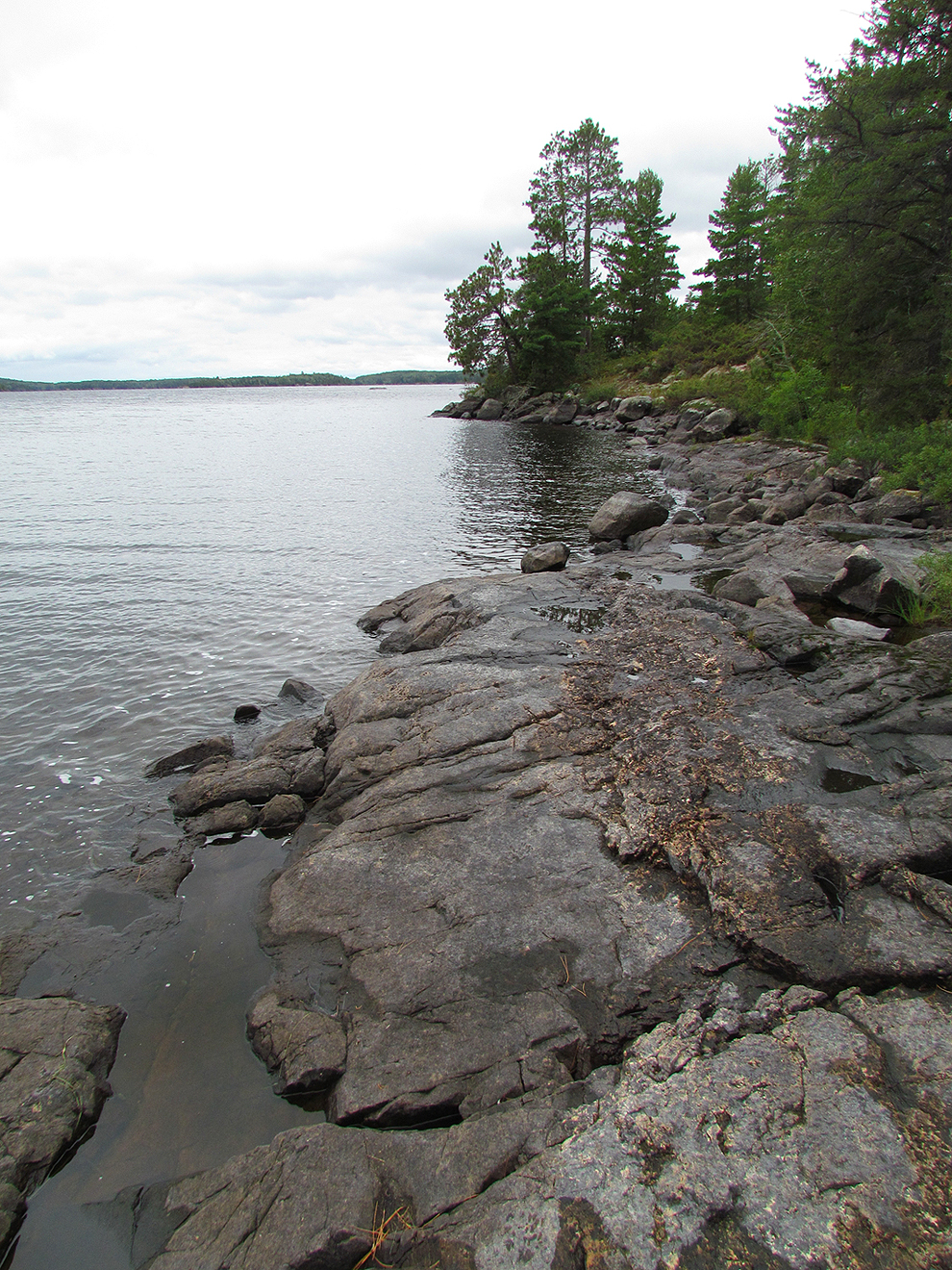
Arriving on Basswood Lake we met the wind head on and on top of this it began to mist a little bit. We found the closest site which was a small island. We didn’t feel up to an attempt to make a fire in the rain so we only dined on Kind Bars, along with a hot tea that we heated on our camp stove for supper. As the temperature continued to fall the forecast on the weather band called for more wind tomorrow. We hope we don’t get wind bound.
Wildlife Sightings: Golden-crowned Kinglet, Dark-eyed Junco, White-throated Sparrow, Beaver lodges, Common Merganser, Black-and-white Warbler, Broad-winged Hawk, Red Squirrel, People
Remember to: Bring more fruit. We brought apples as an after thought and they tasted amazing while out in the backcountry!
DAY # 4: Basswood Lake
Weather: Rain and wind all day until the late evening. High: 9 C Low: 6 C
We are wind bound! Last night the wind picked up, and our tent shook at the top of our somewhat exposed rock and so did the canoe! As night went on it rained with a couple of rumbles of thunder, and then at around 5:00 am the canoe, which was propped next to the tent decided to roll over. Though the canoe was right beside our tent we were at the top of a hill so there was the risk of it rolling down the hill and into the lake! Aaron sprung out of the tent and tied the canoe to some trees. It was at this point we decided to have breakfast in the tent and roll over for a bit more sleep since we had a pretty sleepless night with all this racket! Around 10:00 am the winds were not so much gail force and we explored our little island campsite while gathering some wood in hopes of making a small fire later.
One thing we discovered today was that our weather radio decided to stop working! Not cool! After lunch we had another little nap, organized our gear, and played cards in the tent. After trying the weather radio again and again, it finally started to work and we quickly wrote down the extended forecast for the week ahead which included a chance of frost for the next few days…Yikes!
By late evening the wind finally calmed down and the sun made a brief appearance right before it hid below the horizon as we made a small fire. It was a boost of morale to see the sun and feel its warm glow on our faces, though it was incredibly brief. Maybe we will sleep better tonight.
Wildlife Sightings: Yellow-rumped Warbler, Common Loon, Red-breasted Nuthatch
Remember to: Bring some dental floss. Buy a new wind up weather radio…that works..
DAY # 5: Basswood Lake to Carp Lake
Weather: Clouds with sunny periods, giving way to clouds in the evening. High: 10 C Low: 6 C

Today we got up at 5 am as we had to make up time for being wind bound.
As we finally made our way out onto Basswood Lake again we realized just how big this lake actually is! Besides Lake Erie, this is probably the largest lake we have ever paddled. As we looked way ahead of us the trees on the far shoreline were so distant that we made fun of how they appeared more blue than green in the distant haze.
Marianne began this conversation: “Where are we headed?”
To which Aaron replied: “You see those blue trees over there?”
“Yes”
“When we get there we’re going to the next blue trees”.
Thankfully for us, the breeze was actually at our backs for the majority of the morning. As with everyday thus far we observed other paddlers. Today we saw a few people out fishing in boats with outboard motors, people at campsites, and others using the portages. Located at the southern end of Inlet bay, we arrived at the Prairie Portage ranger station by noon and we went inside the Ontario Parks store. It was here we got to take a look at ourselves in the mirror. Marianne had a heck of a sunburn on her lip and it was currently beginning to hurt and peel. They had internet access at the ranger station and we got the latest extended weather forecast along with additional maps that highlighted the Falls Chain and the Maligne River section of our trip. The Ontario Parks employee reminded us that the Falls Chain section, which comprises a series of portages around sets of falls and rapids, was to be treated with the utmost caution. She continued to state that we were “definitely better off to paddle it downstream rather than upstream where most fatalities happen.”
For some reason that conversation left Marianne a little worried. With all the researching, and even reading accounts from other paddlers that the Falls Chain isn’t that tough, here is an Ontario Parks employee giving us a warning! It made her believe that perhaps the Falls Chain was now out of our league. No turning back now….
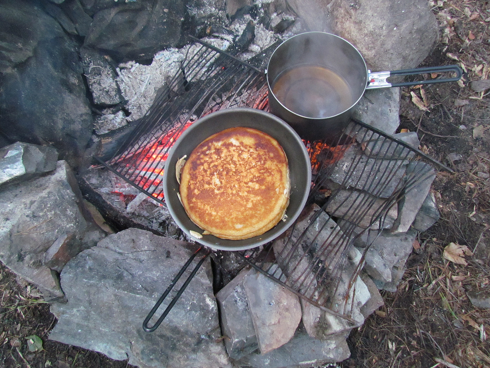
After a short 100 metre portage known as the “Prairie Portage”, which is also an access point into the park, we arrived on Birch Lake. The water here was extremely high to the point that it actually felt a little creepy. After a flat but rocky 200 metre portage we reached Carp Lake and arrived at our site for today. This site was a large treed area next to the portage from Carp Lake to Melon Lake. We were also next to a stream that we could hear babbling nearby. It’s nice to have this “white noise” next to us while sleeping and we were probably less likely now to hear things that go “bump” in the night, like mice that sound as big as bears. Aaron fixed up the fire pit (which seemed to be a common theme on this trip) while Marianne collected firewood. We ended the day by rewarding our nearly 10 hours of paddling and portaging with pancake for supper. Tonight’s forecast stated that it might actually drop down to 0 Celsius!
Wildlife Sightings: Bald Eagle, American Redstart, Magnolia Warbler, Yellow-rumped Warbler, Brown Creeper, Red-breasted Nuthatch, Common Loon, Common Raven, Black-capped Chickadee, Common Merganser, Red Squirrel
Remember to: Put sunscreen on lips, or better yet, buy lip balm with sunscreen in it.
DAY # 6: Carp Lake to Saganaga Lake
Weather: Cloudy with sun and some clouds by evening. High: 14 C Low: 6 C
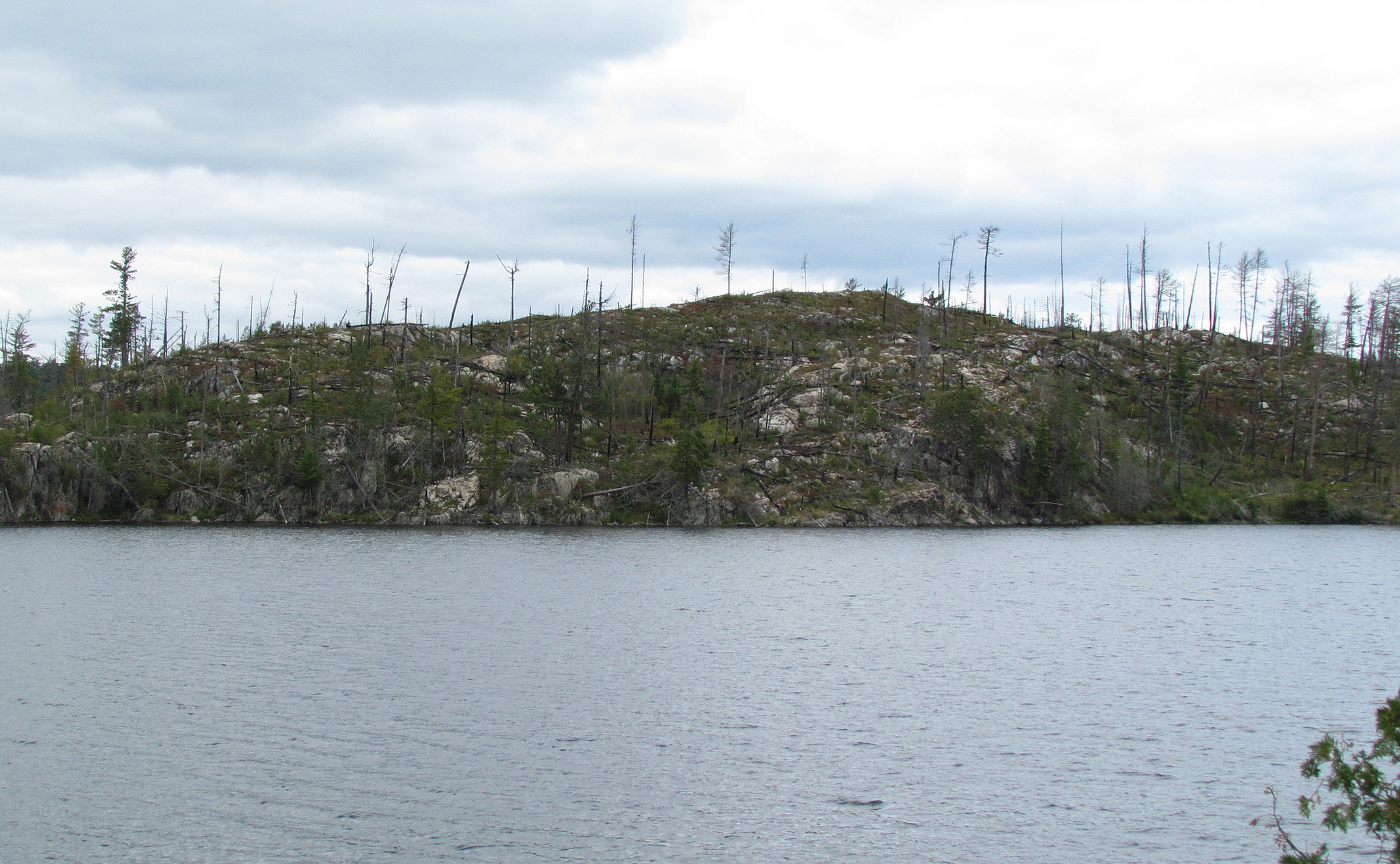
Today we were on the water by 7:45 am. Our first portage was right next to our campsite which was a short 125 metres. On the Fisher Map there are two portages labelled next to our campsite, one on the north side and another on the south side. As far as we can tell the northern one no longer exists, so if you are going to paddle this stretch of the park, please take the southern portage. Continuing east on Seed Lake we hiked the Big Knife portage at 360 metres, which introduced us to the long lake fittingly named Knife Lake. Knife Lake runs along the southeast corner of the park boundary. Our goal was to make sure we got to the end of this lake. One of the reasons being that our Fisher Map shows no campsites on the Canadian side. While paddling this lake we could see why there were no campsites as past forest fires left this section pretty bare, while on the southern American side, it was all lush and treed. It was here that we saw a Black Bear that hightailed it up the hill after seeing us, briefly stopping to turn around and watch us as we continued on. Another interesting sighting was a Merlin chasing a songbird and almost caught it out of the sky!
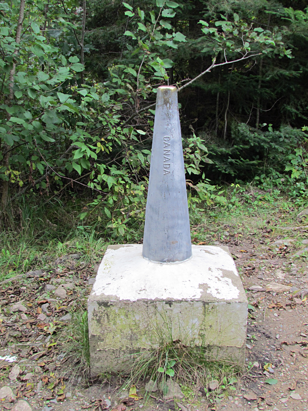
The most interesting portage of the day was the “Monument Portage”, a 420 metre portage from Ottertrack Lake to Swamp Lake. The portage included “stairs”, a makeshift ramp at the Swamp Lake end, and three “monuments” that were way larger than the normal boundary markers we saw while paddling along the Canada/U.S.A border. These larger markers we labelled “U.S.A” on one side and “Canada” on the other.
After a short 25 metre portage we arrived at our site that was a peninsula on Saganaga Lake around 5:15pm. Supper was bannock with peanut butter and jam which we were looking forward to all day. Unfortunately the pan got too hot too fast leaving the bannock uncooked all the way through and making it taste like flour. Yuck!
Wildlife Sightings: Least Chipmunk (a life mammal for us), Black Bear, Bald Eagle, Herring and Ring-billed Gulls, American Pipit, Red-breasted Nuthatch, Merlin, Common Loon, Red Squirrel, People
Remember to: The pre filter on the water pump only lasts for 5 days.
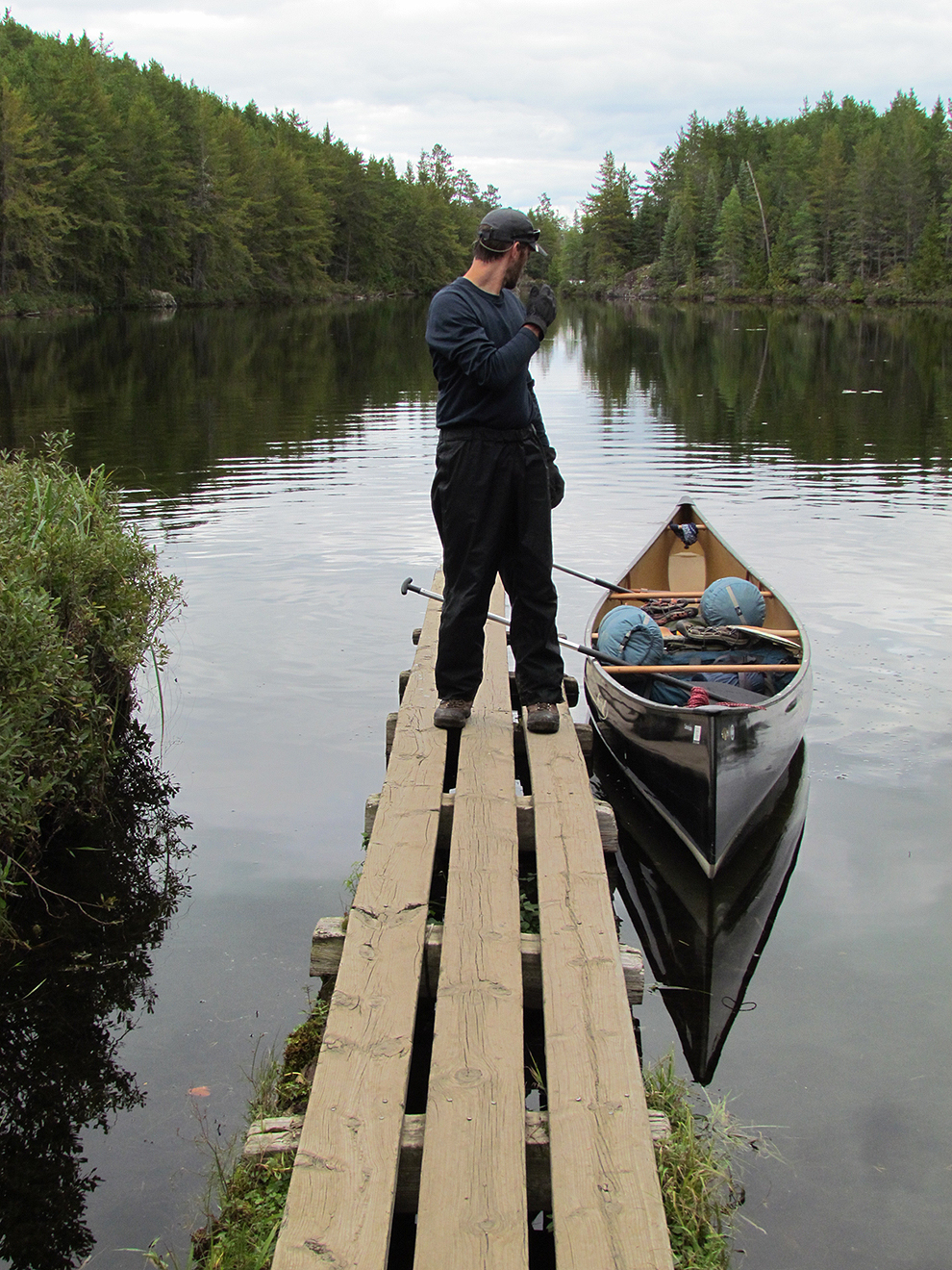
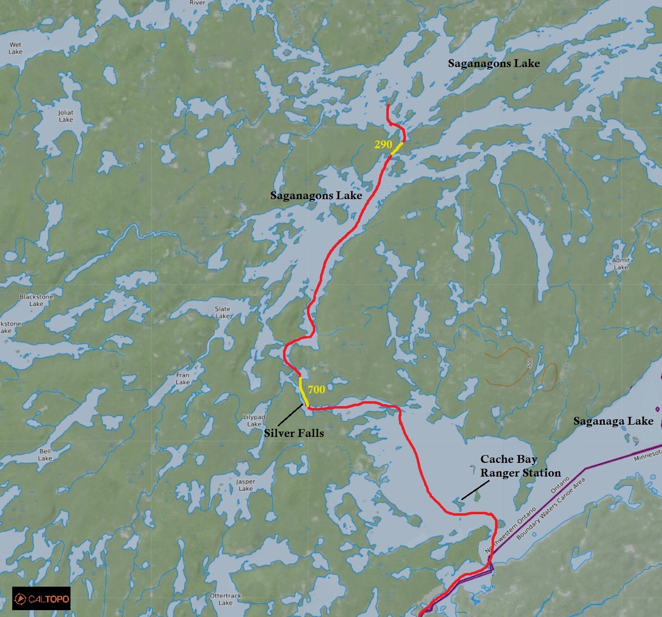
DAY # 7: Saganaga Lake to Saganagons Lake
Weather: Cloudy with sunny breaks. Clouds in the evening. Breezy. High: 14 C Low: 7 C
Today we slept in a bit and didn’t get out onto the water until 8:45 am. We had a more leisurely paddle as we had no large lakes to cross and for the most part the wind was at our backs. As we paddled north on Cache Bay we docked at the currently non operating ranger station. While we stretched our legs six more people arrived in canoes as well. We introduced ourselves and discovered that they were a group of fishermen that were flown in. Included in their party was a gentleman from Alabama and his friend from New Mexico. Quetico and the surrounding waters are well known as a premier fishing location in North America and fly in fishing trips are common.
Paddling to the northwest end of Cache Bay we arrived at the 700 metre portage known as the “Silver Falls portage”. The falls run parallel to this well used portage that was your typical ascending and descending trek with rocks and mud in-between for good measure. The falls was most impressive at the beginning of the portage where, with the water being high, was quite dramatic!
After finishing this scenic portage we had lunch (Mountain House Turkey Tetrazinni, and Pasta Primivera) at a lovely site up on a hill on Saganagons Lake. Paddling north we reached the “Dead Man’s Portage”. At 290 metres in length there is a 20 foot section towards the middle that had a sloped rock you have to portage. If it was wet it could be quite dangerous. Paddling further north on Saganagons Lake it was time to find a site for the night. The island sites were not very appealing and we settled on a mediocre site that included a huge fallen tree right in the middle of the site which would have been the perfect spot for the tent. As the afternoon went on and the breeze began to pick up we retreated to the tent and went over our plan of action for the Falls Chain. This may be the most dangerous part of our whole trip. We hope it doesn’t rain tomorrow.
Wildlife Sightings: Grey Jay, Golden-crowned Kinglet, Dark-eyed Junco, White-throated Sparrow, Yellow-rumped Warbler, Common Merganser, Common Loon, Red Squirrel
Remember to: Six water purifying tablets per day is only the minimum. Repair hole in the tent. New stuff sacks for sleeping pads. Fix stuff sack for sleeping bag after the trip.
DAY # 8: Saganagons Lake to Kawnipi Lake (Atkins Bay)
Weather: Rain in the morning with rain and wind in the afternoon, followed by sun and wind in the evening. High: 13 C Low: 7 C
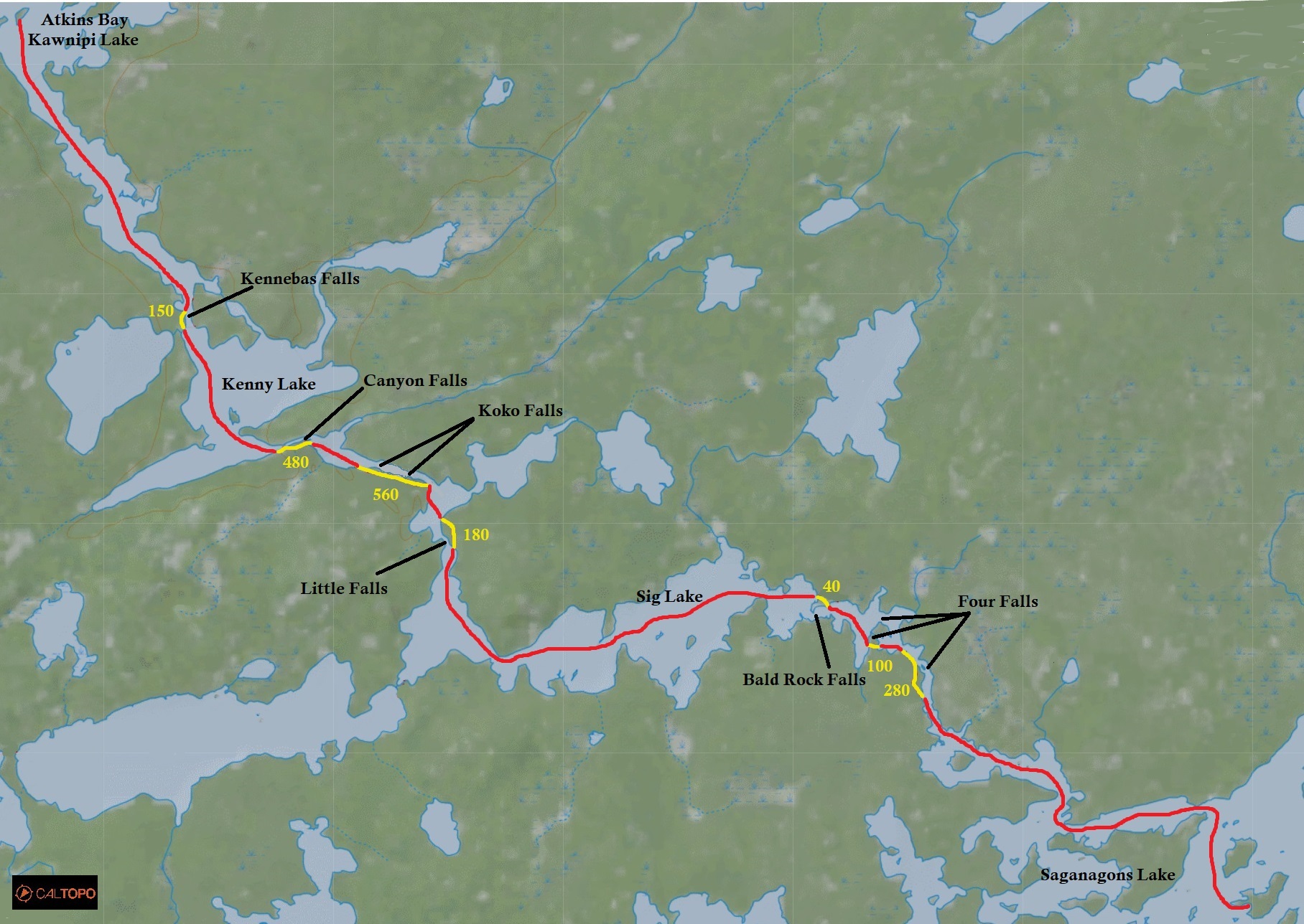
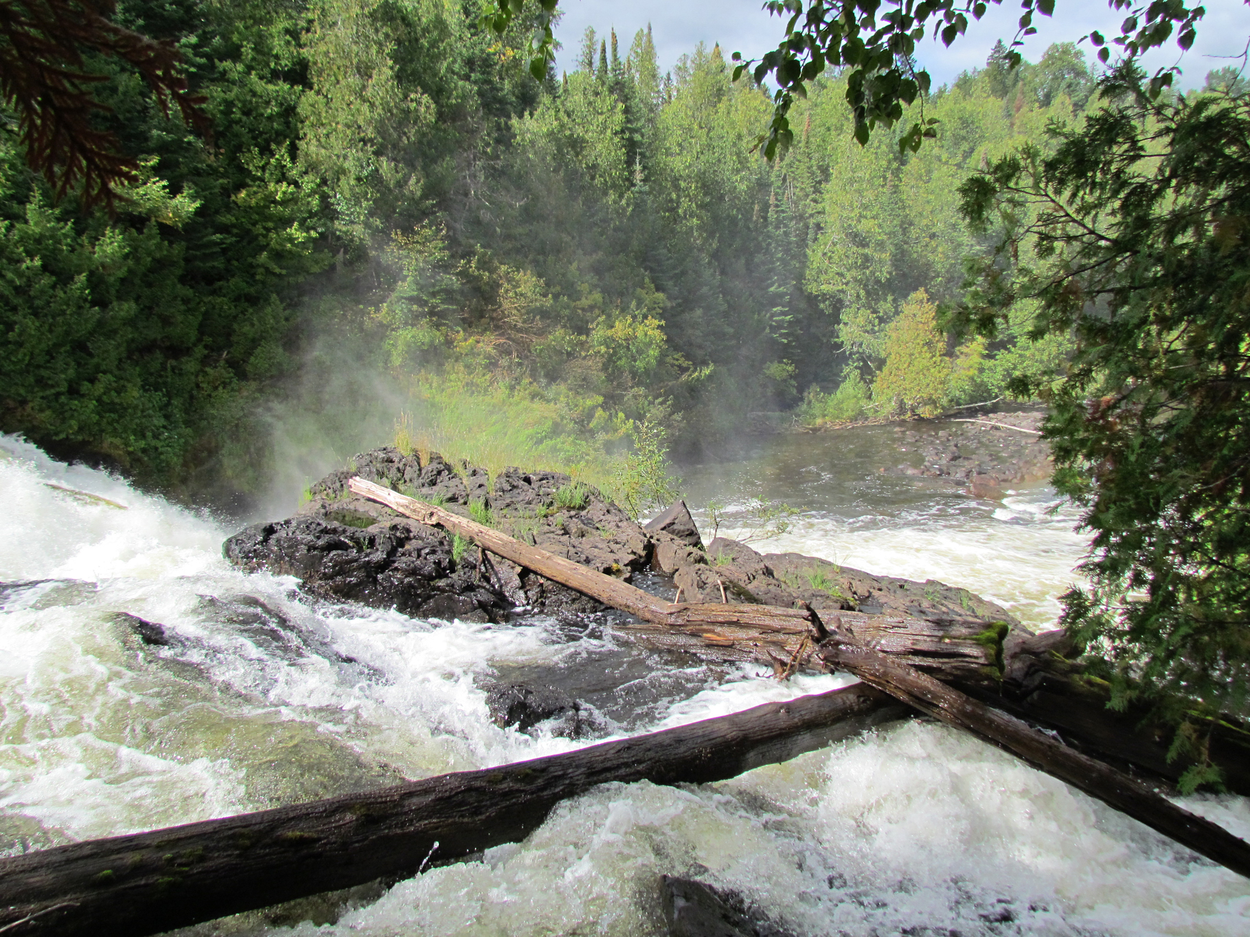
We set the alarm early for 4:30 am but we didn’t sleep very well. It was raining and a little windy when we woke up so we fell back to sleep. By 8:40am we were out on the water and it looked like the skies were beginning to clear, though the breeze stayed. These were not the ideal conditions we wanted to do the Falls Chain in but we didn’t have much of a choice.
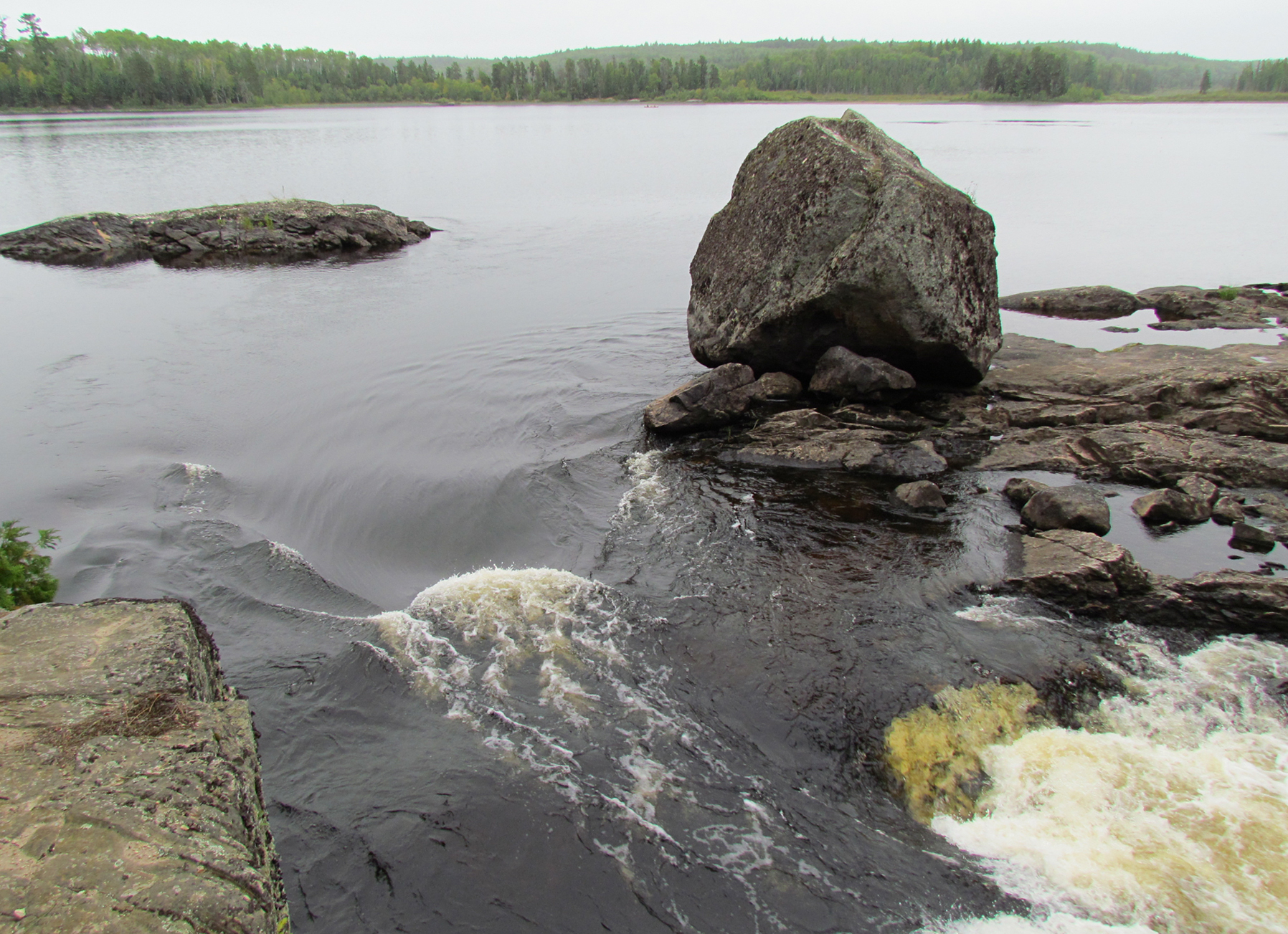
The first portage along the chain was known as the “Four Falls” at 280 metres, followed by a 100 metre portage. The second was the Bald Rock Falls at 40 metres. Both these portages were pretty straightforward. After another easy 180 metre portage at Little Falls the portages became more complex. Koko Falls at 560 metres had a lot of rocks and mud, while Canyon Falls at 480 metres had rocks and mud but more ascending and descending in sections. All put ins and take outs were fairly easy until we reached the put in at the last section called Kennebas Falls which was rocky and our canoe received more battle scars. It was also at the takeout at the top of Kennebas Falls, that we saw a Kevlar canoe (most likely a rental) wedged underneath a tree in the water. Not a fun time for those individuals I’m sure.
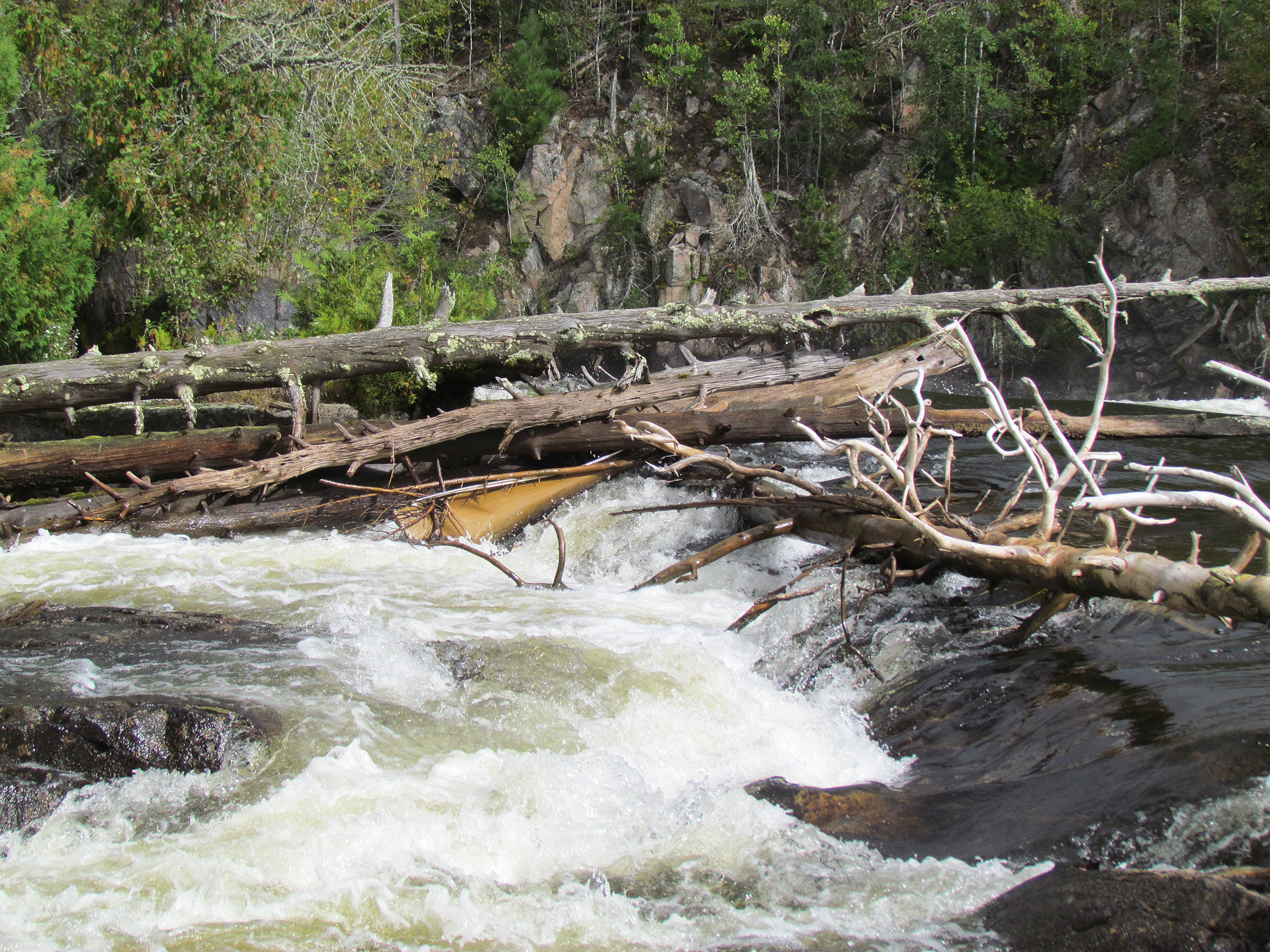
After finally getting into the canoe at the rocky put in at Kennebas Falls we got to breathe a sigh of relief as we completed the Falls Chain. We think we rocked it out in 5 hours. Even after reading all the warnings from various sources we thought it wasn’t that bad at all, though an upstream paddle would’ve been a lot more challenging. Going downstream at the top of the falls we just made sure that someone held onto the canoe while the other got out. At ice out we wonder if it would be a lot more terrifying along this stretch!
Paddling our way northwest onto Kawnipi Lake we were sheltered for awhile until we hit some big winds out on Atkins Bay where we headed towards an island. This island supposedly had a campsite on it that Marianne researched online at paddleplanner.com. At the top of the small island there was a flat spot just large enough for our small two person tent. It was actually a pretty nice spot but no firewood to be found. The island also had quite a drop to the water next to our tent. Good thing neither of us sleep walks! While gazing out onto the open waters of Kawnipi Lake from our tiny island we don’t see another paddler for the rest of the day. The forest surrounding Kawnipi Lake looked a little stunted with many trees at the same height, succession as the result of a forest fire back in 1995. Tomorrow we will be getting up early as we are just a little behind where we want to be.

Wildlife Sightings: Bald Eagle, Pine Siskin, Common Raven, Common Loon, Red Squirrel, Hooded Merganser, Black-capped Chickadee, Yellow-rumped Warbler, People
Remember to: No remember to today! Whoot!
DAY # 9: Kawnipi Lake to Russell Lake
Weather: Partly sunny in the morning to partly cloudy and breezy in the afternoon. High: 17 C Low: 10 C

After two days of not getting very far, and with the weather radio forecasting lighter head winds today, we set the alarm for 4:30 am. We were back on the water by 7:10 am and paddled the whole length of Kawnipi Lake in 4 hours in both fair and breezy conditions. Though paddling the length of the lake in that time was quite a feat for us, we did miss a side trip to look for some more pictographs. We took a break for lunch at a scary campsite full of widow makers, which was a nice break for our legs and arms. A short 20 metre portage between Kawnipi and Kahshahpiwi Creek was our first portage for the day that went around some rapids, while at the next “portage” we just ended up running through some swifts. One more short portage around some rapids and we arrived at an easy 300 metre portage known as the “Have a Smoke Portage” to Keats Lake. Not sure how the “Have a Smoke Portage” got it’s name. The only suggestion we found online was that because the portage has a lot of rocks at the one put in/take out it would be safe to have a smoke without risk of forest fire. If you are paddling this section please stay away from the alternate portage called “Snake Falls” as we were told by various sources that this portage is dangerous to attempt.
On Keats Lake we had a tricky takeout at the 420 metre “Split Rock Falls” and battled some more head winds yet again as we paddled our way west on Chatterton Lake heading towards Russell Lake. Our last portage of the day was a 410 metre into Russell Lake and we paddled our way to a campsite on a peninsula. We also had neighbours a fair distance away that were on a nearby peninsula. In the distance we could just hear Chatterton Falls which was near our last portage. The view of Chatterton Falls is supposed to be well worth the look, but we really just wanted to get to our site and rest as we were tired of head winds for one day.
Today was the longest we have ever paddled at 11 hours and at around 38 kilometres. The weather was finally getting warmer again, our canoe had some pretty good battle scars on the hull, and everyday we’ve seen solo canoeists and families enjoying Quetico!
Wildlife Sightings: River Otter, Bald Eagle, Mouse (Deer Mouse?), Pine Siskin, American Pipits (migrating south), Yellow-rumped Warbler, Blue Jay, Common Raven, Common Loon, People
Remember to: No remember to today! Whooot!
DAY # 10: Russell Lake to Sturgeon Lake
Weather: Partly sunny with wind in the morning to partly cloudy and breezy in the afternoon. Calm with a mix of sun and cloud in the evening. High: 17 C Low: 10 C
After rocking it out yesterday we had a good nights sleep and slept in a bit. We rolled out of the tent around 6:30 am, had pancakes, and were back on the water by 8:30 am. We battled some west winds (yes more head winds yet again!) out of Russell Lake and arrived at our only portage for the day, a 540 metre portage known as the “staircase portage” into Sturgeon Lake. Boy were they right in naming this portage! It was the steepest one for the whole trip and we saw fresh bear scat along it. After giving our legs a workout it was back to giving our arms another workout battling the headwinds on Sturgeon Lake. It wasn’t too bad for a while as we hid behind some islands, but Sturgeon Lake is pretty long and fairly wide. Half way down its length the waves got larger and soon we had to wait out the winds for 2 hours at what was probably the most beautiful campsite we have seen to date here. The site was on a sandbar, the first sandbar campsite we have ever seen in this park. It was like we were in southern Ontario again! The landing was all smooth sand and the site itself was flat and huge. Walking to the west side of the sandspit to look out over the western half of Sturgeon Lake was all whitecaps. NOPE! It was time to take a break, have lunch, and bath in the warm water (we haven’t properly bathed since day two).
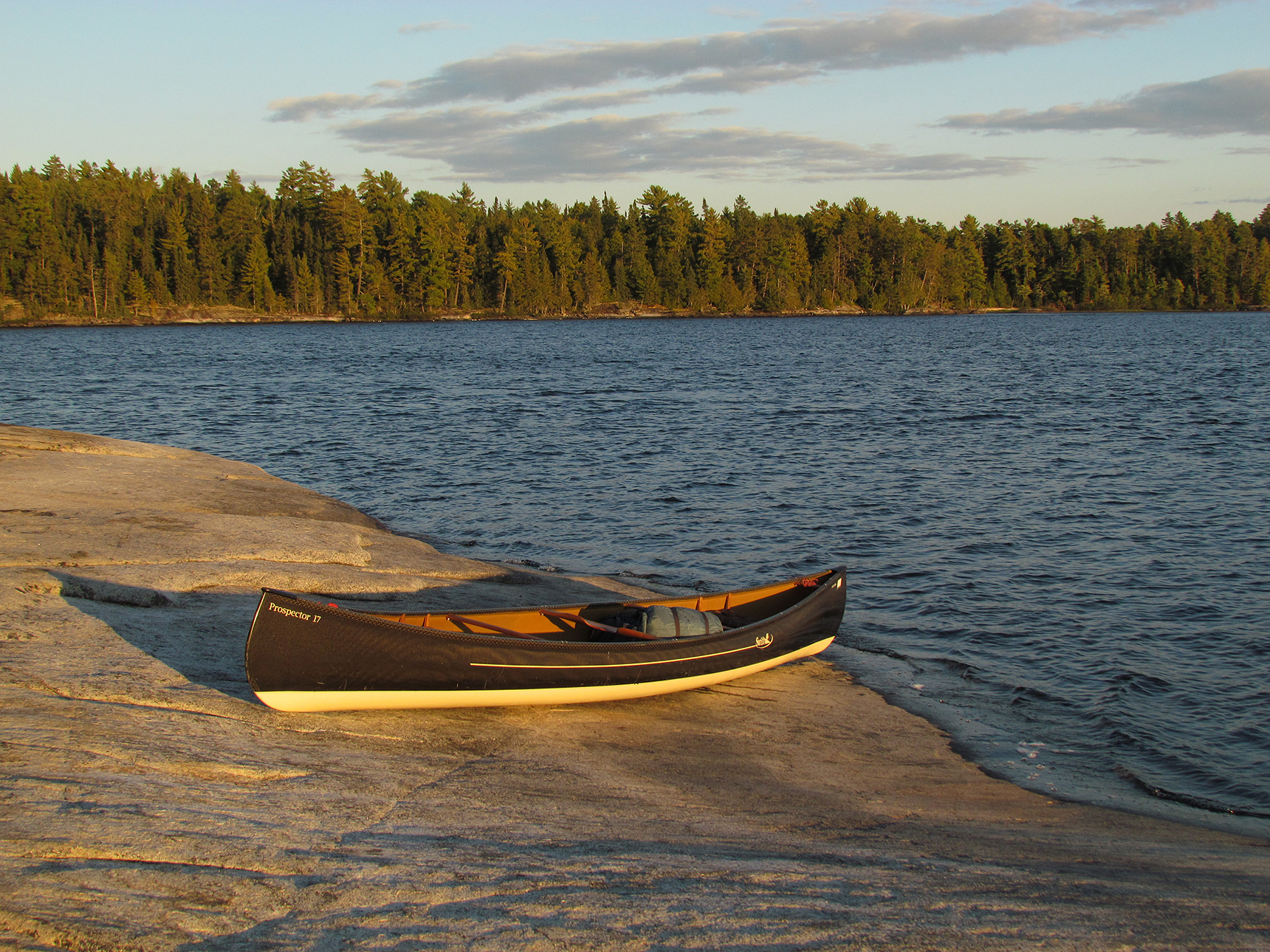
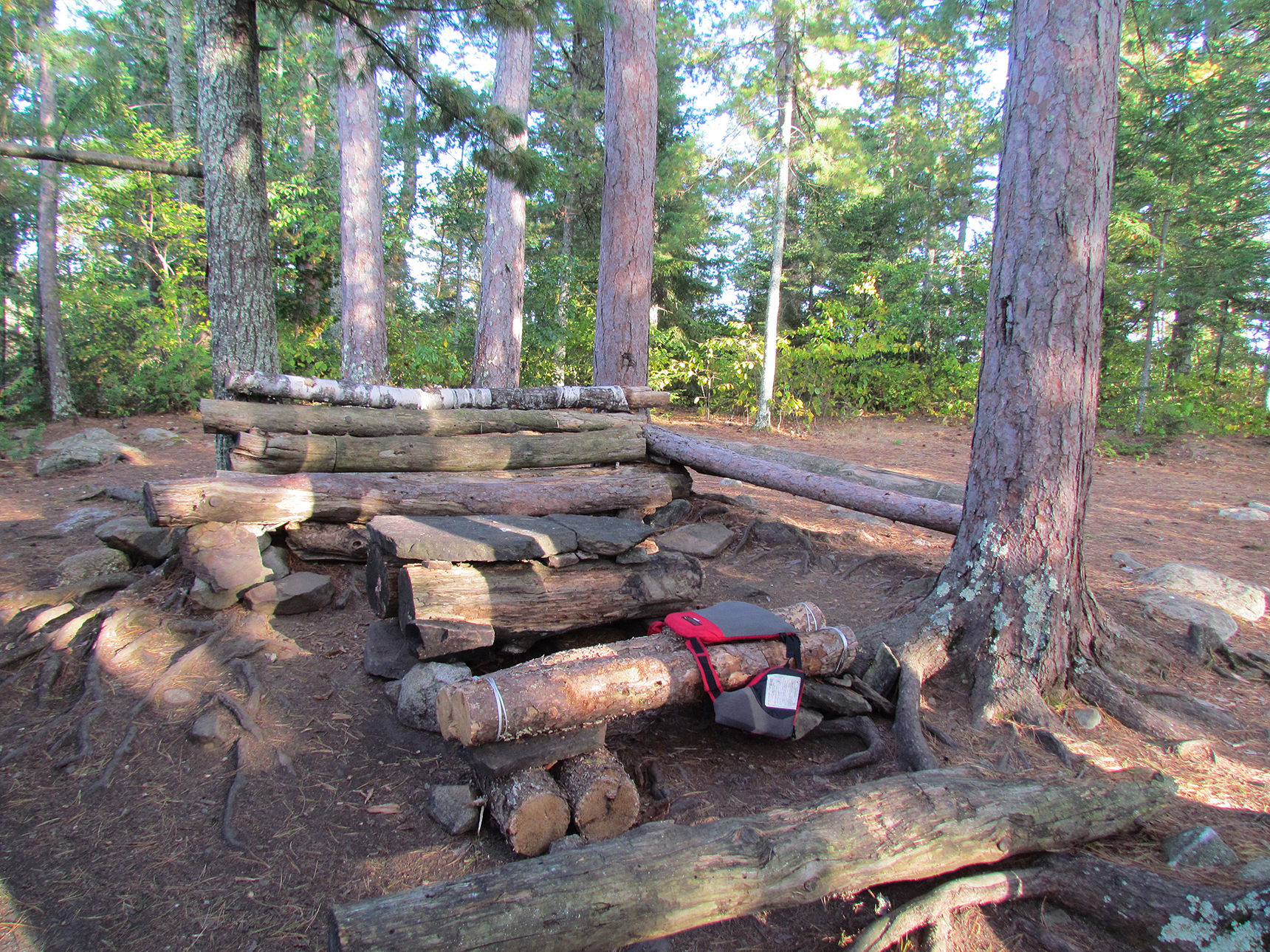
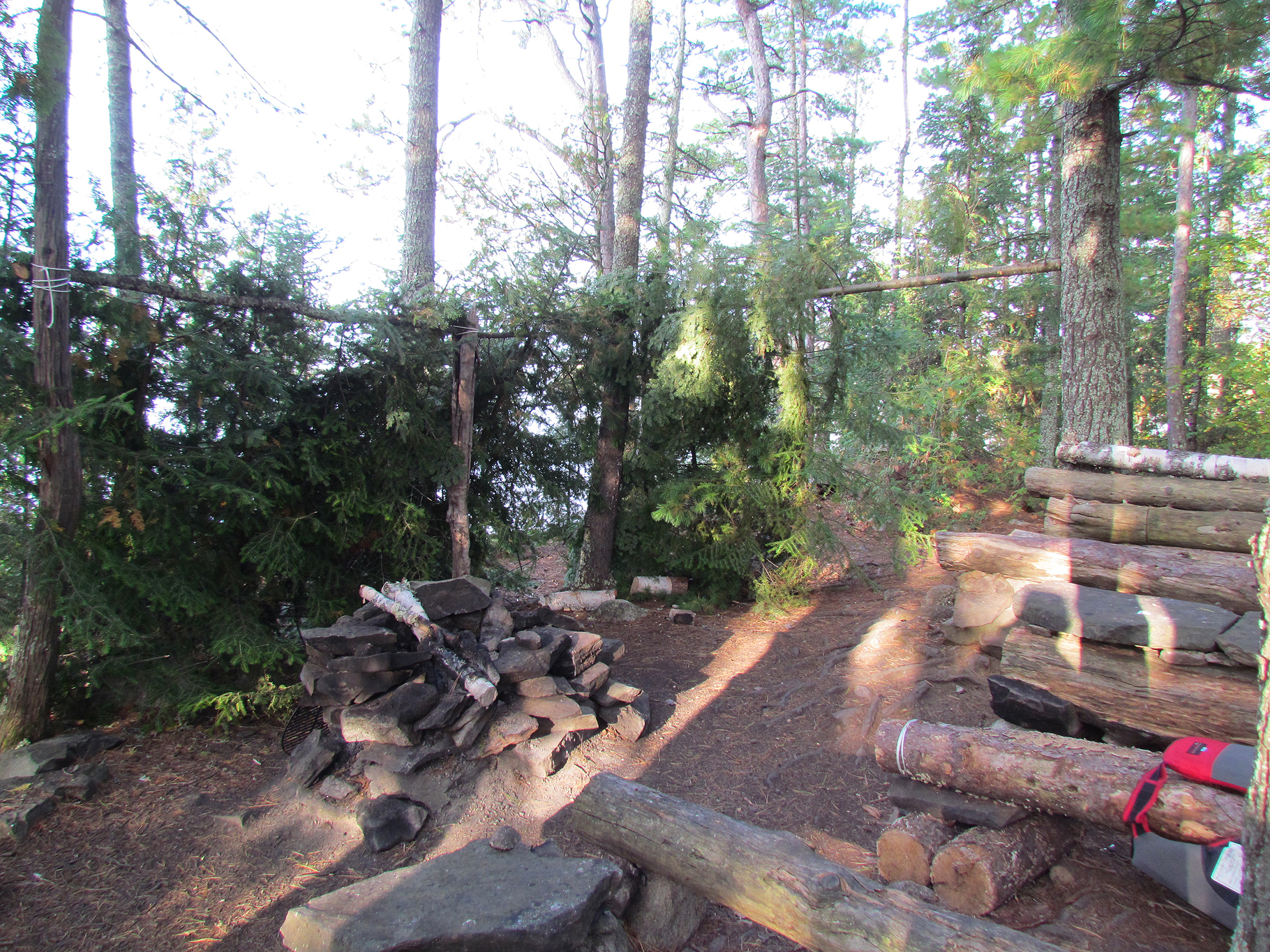
While enjoying this sheltered beauty of a site we noticed that the whitecaps died down, so reluctantly we loaded up the canoe again and continued to the western end of Sturgeon Lake to a site on an island before Sturgeon Lake meets the Maligne River. It was a fair sized island and the site itself looked like it was set up for a film shoot! There were large rocks and logs made into seats and tables. Unfortunately, some young trees were cut down to create a wind shelter which is not really allowed in a provincial park. Clearly a lot of work was put into this site to make it what it is!
Listening to our weather radio we learned that northeast winds were forecasted for tomorrow, while the following day called for thunderstorms and west winds. It was decision time. Should we try to paddle the length of the Maligne River and head west returning to Lac La Croix and the car tomorrow, or extend the trip into a relaxing two days while paddling the large expanse of Lac La Croix in west winds and potential thunderstorms the following day? Not wanting to deal with head winds anymore we decided to try for the long haul and paddle both the Maligne River and the length of Lac La Croix back to the launch and the car tomorrow. We ended up having a quick meal of Kind bars and tea and went to bed early.
Wildlife Sightings: Red Squirrel, Crayfish, Pine Siskin, Common Loon, Pileated Woodpecker, Belted Kingfisher
Remember to: Pack less food and bars. We packed too much!
DAY # 11: Sturgeon Lake to Lac La Croix
Weather: Light showers in the morning. Partly cloudy in the afternoon. High: 17 C Low: 10 C
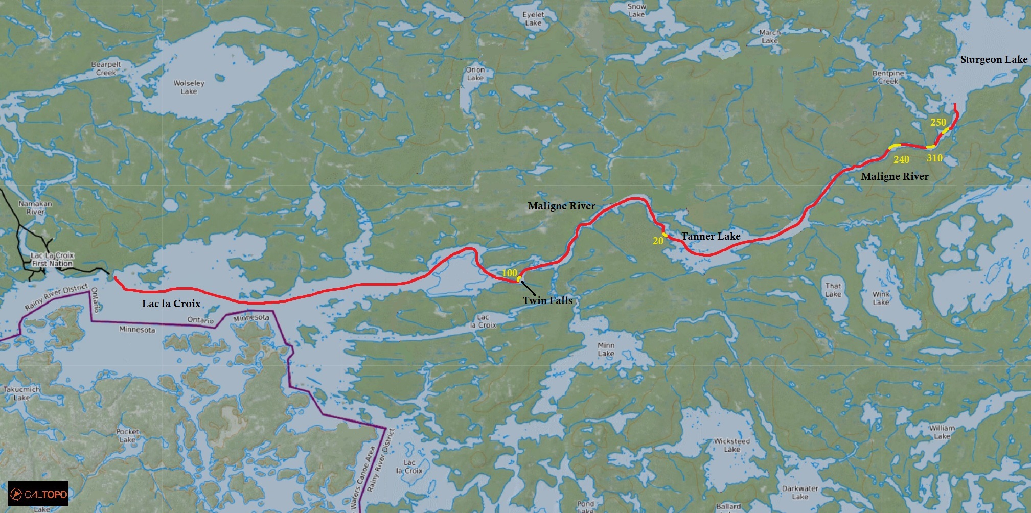
We were up by 4:30 am, had breakfast in the dark, and waited until it got light enough to see before heading out in the clouds and light rain around 7:00 am. Before we knew it we were on the Maligne River. The first portage at 261 metres at the mouth of the Maligne was an easy go as was the second at 322 metres. There was a new portage placed in the spring for the third one due to high water and rough rapids, however now the water level was lower and we easily ran it. After the fourth portage at 211 metres we entered Tanner Lake. Maybe because it was our last day of our trip, but Tanner Lake felt like it took FOREVER to cross! We went around and through some rapids which took some maneuvering. All was going pretty smoothly until we found ourselves getting stuck on a flat rock in fairly fast moving water worried that we may topple over as the canoe began to turn sideways in the rapids. We shimmied back and forth in the canoe on the rock, eventually freeing ourselves and continued on our way. We took a much needed break at our very last portage at Twin Falls. Here we were greeted by a couple of Grey Jays that came to investigate our lunch (which was left over beef jerky and cheese). After our last 80 metre portage on the west side of Twin Falls, we arrived back on Lac La Croix, now almost completing the full circle of the Hunter Island Loop.
The wind was from the Northeast as forecasted as we began our paddle back to the launch. Paddling the wide expanse of Lac La Croix, hearing the distant humming of a motorboat far off in the distance we reached that part of the trip where we have mixed emotions of wanting to stay longer but also desiring a real shower and a cold glass of milk. Perhaps we were not out long enough to suppress those cravings? Even if there was a campsite right next to the launch, right next to our car, we would still choose to get in our car and go to a motel….a cold glass of milk…a hot shower..
Arriving at the launch we were quite sore. Aaron was sore in the lower neck from the yoke of the canoe, while Marianne’s right shoulder was sore and her finger tips were getting numb from the long paddle. Instead of mosquitoes greeting us at the car we were welcomed instead by a swarm of blackflies as we strapped the canoe on top. After packing it all in we walked back to the dock at the launch for a victory hug and high five. We did it! We did the Hunter Island Loop! Our first real successful trip in Quetico Provincial Park! Not only that, this is also by far our best canoe trip yet! We will be back Quetico, as you still have a lot of lakes and portages that we have yet to explore!
Wildlife Sightings: Common Loon, Common Raven, Gray Jays, Pine Siskins, Ring-billed Gull, Bald Eagle, Merlin, Red Squirrel, Eastern Chipmunk, Black-capped Chickadee
Remember to: Buy a new map case

Click The Link For More Trip Reports: http://www.backcountrybalkwills.com
